
California State Route 25
Encyclopedia
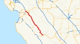
State Route 25 is a state highway
in the U.S. state
of California
between Gilroy
and State Route 198
. This route is part of the California Freeway and Expressway System
and is eligible for the State Scenic Highway System
.
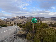 SR 25 (also known as Bolsa Road and the Airline Highway) begins at the intersection of Peach Tree Road and State Route 198
east of Priest Valley, in Monterey County
, and is the northern extension of Peach Tree Road. It heads northwest, crossing into San Benito County
and passing through the community of Bitterwater
. SR 25 provides access to the Pinnacles National Monument
east entrance, running parallel to the San Andreas Fault
. Running parallel to the Diablo Range
, SR 25 passes through the communities of Paicines
and Tres Pinos
and the city of Hollister
. SR 25 continues northwest from Hollister, intersecting with State Route 156, and ends at U.S. Route 101 in Gilroy.
{| class=wikitable
!County
!Location
!Postmile
!Destinations
!Notes
|-
|Monterey
MON 0.00-11.75
|
|0.00
|
|
|-
|rowspan=5|San Benito
SBT 0.00-60.08
|
|21.47
| – Pinnacles National Monument
|
|-
|Paicines
|39.53
|
|
|-
|rowspan=2|Hollister
|49.95
|Tres Pinos Road, Sunnyslope Road
|Tres Pinos Road was former SR 25 north
|-
|L52.23
51.45
|
|Former SR 25 south / SR 156
|-
|
|54.05
|
|
|-
|Santa Clara
SCL 0.00-2.56
|
|2.56
|
|Interchange
State highway
State highway, state road or state route can refer to one of three related concepts, two of them related to a state or provincial government in a country that is divided into states or provinces :#A...
in the U.S. state
U.S. state
A U.S. state is any one of the 50 federated states of the United States of America that share sovereignty with the federal government. Because of this shared sovereignty, an American is a citizen both of the federal entity and of his or her state of domicile. Four states use the official title of...
of California
California
California is a state located on the West Coast of the United States. It is by far the most populous U.S. state, and the third-largest by land area...
between Gilroy
Gilroy, California
Gilroy is the southernmost city in Santa Clara County, California, United States. The population was 48,821 at the 2010 census. Gilroy is well-known for its garlic crop and for the annual Gilroy Garlic Festival, featuring various garlicky foods, including garlic ice cream. Gilroy also produces...
and State Route 198
California State Route 198
State Route 198 is an east–west state highway that connects the California Central Coast to the mid-Central Valley at Visalia, although the most-traveled portion is in the Central Valley itself....
. This route is part of the California Freeway and Expressway System
California Freeway and Expressway System
The California Freeway and Expressway System is a system of existing or planned freeways and expressways in the U.S. state of California. It is defined by the Streets and Highways Code.-List of roads in the system:*State Route 1 *State Route 2...
and is eligible for the State Scenic Highway System
State Scenic Highway System (California)
The State Scenic Highway System is a list of highways, mainly state highways, that have been designated by the California Department of Transportation as scenic highways. The California State Legislature, primarily through Section 263 of the Streets and Highways Code, makes highways eligible for...
.
Route description
California State Route 198
State Route 198 is an east–west state highway that connects the California Central Coast to the mid-Central Valley at Visalia, although the most-traveled portion is in the Central Valley itself....
east of Priest Valley, in Monterey County
Monterey County, California
Monterey County is a county located on the Pacific coast of the U.S. state of California, its northwestern section forming the southern half of Monterey Bay. The northern half of the bay is in Santa Cruz County. As of 2010, the population was 415,057. The county seat and largest city is Salinas...
, and is the northern extension of Peach Tree Road. It heads northwest, crossing into San Benito County
San Benito County, California
San Benito County is a county located in the Coast Range Mountains of the U.S. state of California, south of San Jose. As of 2010 the population was 55,269. The county seat is Hollister, which includes nearly two-thirds of the county's population. El Camino Real passes through the county and...
and passing through the community of Bitterwater
Bitterwater, California
Bitterwater is an unincorporated community in the Bitterwater Valley of San Benito County, California, United States.Bitterwater Valley, located at the base of the San Andreas, California Mountains - on a crucial earthquake fault line, was once the primary habitat of the giant California Condors...
. SR 25 provides access to the Pinnacles National Monument
Pinnacles National Monument
Pinnacles National Monument is a protected mountainous area located east of central California's Salinas Valley, just miles from the town of Soledad...
east entrance, running parallel to the San Andreas Fault
San Andreas Fault
The San Andreas Fault is a continental strike-slip fault that runs a length of roughly through California in the United States. The fault's motion is right-lateral strike-slip...
. Running parallel to the Diablo Range
Diablo Range
The Diablo Range is a mountain range in the California Coast Ranges subdivision of the Pacific Coast Ranges. It is located in the eastern San Francisco Bay area south to the Salinas Valley area of northern California, the United States.-Geography:...
, SR 25 passes through the communities of Paicines
Paicines, California
The unincorporated community of Paicines is located at above mean sea level in San Benito County, California along State Route 25. Guide signs along SR25 say the community is south of Hollister. The community is at the intersection of Panoche Road and SR25...
and Tres Pinos
Tres Pinos, California
Tres Pinos is a census-designated place in San Benito County, California. The community lies along State Route 25, approximately 4 miles south of Hollister and 5 miles north of Paicines. Tres Pinos sits at an elevation of...
and the city of Hollister
Hollister, California
Hollister is a city in and the county seat of San Benito County, California, United States. The population was 34,928 at the 2010 census. Hollister is primarily an agricultural town.-History:...
. SR 25 continues northwest from Hollister, intersecting with State Route 156, and ends at U.S. Route 101 in Gilroy.
Major intersections
- Note: Except where prefixed with a letter, postmiles were measured in 1964, based on the alignment as it existed at that time, and do not necessarily reflect current mileage. The numbers reset at county lines; the start and end postmiles in each county are given in the county column.
{| class=wikitable
!County
!Location
!Postmile
!Destinations
!Notes
|-
|Monterey
Monterey County, California
Monterey County is a county located on the Pacific coast of the U.S. state of California, its northwestern section forming the southern half of Monterey Bay. The northern half of the bay is in Santa Cruz County. As of 2010, the population was 415,057. The county seat and largest city is Salinas...
MON 0.00-11.75
|
|0.00
|
|
|-
|rowspan=5|San Benito
San Benito County, California
San Benito County is a county located in the Coast Range Mountains of the U.S. state of California, south of San Jose. As of 2010 the population was 55,269. The county seat is Hollister, which includes nearly two-thirds of the county's population. El Camino Real passes through the county and...
SBT 0.00-60.08
|
|21.47
| – Pinnacles National Monument
Pinnacles National Monument
Pinnacles National Monument is a protected mountainous area located east of central California's Salinas Valley, just miles from the town of Soledad...
|
|-
|Paicines
Paicines, California
The unincorporated community of Paicines is located at above mean sea level in San Benito County, California along State Route 25. Guide signs along SR25 say the community is south of Hollister. The community is at the intersection of Panoche Road and SR25...
|39.53
|
|
|-
|rowspan=2|Hollister
Hollister, California
Hollister is a city in and the county seat of San Benito County, California, United States. The population was 34,928 at the 2010 census. Hollister is primarily an agricultural town.-History:...
|49.95
|Tres Pinos Road, Sunnyslope Road
|Tres Pinos Road was former SR 25 north
|-
|L52.23
51.45
|
|Former SR 25 south / SR 156
California State Route 156
State Route 156 is a state highway in California, USA, running from Castroville to State Route 152 near Hollister.This route is eligible for the State Scenic Highway System.-Route description:...
|-
|
|54.05
|
|
|-
|Santa Clara
Santa Clara County, California
Santa Clara County is a county located at the southern end of the San Francisco Bay Area in the U.S. state of California. As of 2010 it had a population of 1,781,642. The county seat is San Jose. The highly urbanized Santa Clara Valley within Santa Clara County is also known as Silicon Valley...
SCL 0.00-2.56
|
|2.56
|
|Interchange