
California State Route 204
Encyclopedia
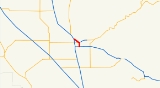
State Route 204 is a short state highway
in the Bakersfield, California
, United States
area. It connects SR 99
and SR 58
with downtown. It also connects Bakersfield's three major freeways together (SR 99, SR 58, and SR 178
). Only the north 1.4 miles has been built to freeway standards; the rest is a six-lane arterial road.
All of SR 204 is a part of State Route 99 Business. The business route also continues south, where it meets with SR 99.
In the mid 1930s US 99 was moved from Chester Ave./Roberts Ln. to Union Ave./Golden State Ave. During the late 1950s, the Union Ave. Wye, Truxton Ave. Interchange, and Chester Ave. Interchange (with the bridge over Garces Circle) were constructed to improve traffic flow. However, when the US 99 freeway bypass was constructed in 1963, Caltrans decided to use the Oak St. route around the city instead of the Union Ave. route through the city. As a result, the route designations were swapped. The freeway parallel to Oak St. would become US 99. LRN 141 would become the US 99 bypass via Brundage Ln, Union Ave, and Golden State Ave. That designation never took effect because in 1963 all of the state highways were renumbered. As a result, LRN 141 became SR 204. Its definition was also simplified to bypass SR 99 via Union Ave. and Golden State Ave, although that change lengthened the route. In 1978, the route was shortened to connect SR 58 to SR 99 via Union Ave. and Golden State Ave, which was close to the original 1963 definition.
The entire route is in Bakersfield
, Kern County
.
{| class=wikitable
!Postmile
!Exit
!Destinations
!Notes
|-
|0.00
|
|
|Continuation beyond SR 58; former US 99 south / SR 204 south
|-bgcolor=#ddffdd
|R0.00-R0.10
|
|
|Interchange; south end of SR 99 Bus. overlap
|-
|2.07
|
|Brundage Lane
|
|-
|3.09
|
|California Avenue, East California Avenue
|
|-
|3.41
|
|Truxtun Avenue
|Interchange
|-
|3.76
|
| Union Avenue to SR 178
|
|-
|
|
|Sumner Street
|Former US 466 east
|-
|4.06
|
| 24th Street to SR 178
west
|
|-bgcolor=#ffdddd
|4.24
|
|
|Interchange; southbound exit and northbound entrance
|-
|4.88
|
|Chester Avenue – Oildale
|Interchange
|-
|5.14
|
|F Street
|
|-
|colspan=4 align=center|South end of freeway
|-
|6.46
|6
|
|Airport Drive serves Meadows Field Airport
|-bgcolor=#ddffdd
|6.75
|
|
|Northbound exit and southbound entrance; north end of SR 99 Bus. overlap; former US 99 north / US 466 west
State highway
State highway, state road or state route can refer to one of three related concepts, two of them related to a state or provincial government in a country that is divided into states or provinces :#A...
in the Bakersfield, California
Bakersfield, California
Bakersfield is a city near the southern end of the San Joaquin Valley in Kern County, California. It is roughly equidistant between Fresno and Los Angeles, to the north and south respectively....
, United States
United States
The United States of America is a federal constitutional republic comprising fifty states and a federal district...
area. It connects SR 99
California State Route 99
California State Route 99 , commonly known as Highway 99 or, simply, as 99 , is a north–south state highway in the U.S. state of California, stretching almost the entire length of the Central Valley...
and SR 58
California State Route 58
State Route 58 is an east-west highway across the California Coast Ranges, the southern San Joaquin Valley, the Tehachapi Mountains, which border the southern Sierra Nevada, and the Mojave Desert. It runs between its western terminus near Santa Margarita and its eastern terminus at Barstow...
with downtown. It also connects Bakersfield's three major freeways together (SR 99, SR 58, and SR 178
California State Route 178
State Route 178 is a route that exists in two constructed segments. The gap in between segments is connected by various local roads and State Route 190 through Death Valley National Park....
). Only the north 1.4 miles has been built to freeway standards; the rest is a six-lane arterial road.
All of SR 204 is a part of State Route 99 Business. The business route also continues south, where it meets with SR 99.
Route description
SR 204 begins as a six-lane arterial at the intersection of SR 58 and Union Ave. From there, the route travels north on Union Ave, crossing the Truxtun Ave. interchange. At the Union Ave. Wye, the route turns northeast on Golden State Ave. It then crosses SR 178 and Garces Circle, which provides access to Downtown Bakersfield. The route then crosses F St, at which point it becomes a four-lane freeway. The route crosses its only numbered interchange at Airport Dr, and then terminates at SR 99.History
Before the 1964 renumbering, State Route 204 was known as Legislative Route 141. It was created in 1933 as a western bypass to Bakersfield via Brundage Ln. and Oak St. At that time, US 99 (defined by the State as Legislative Route 4) ran through Bakersfield via Chester Ave, and through Oildale (north of Bakersfield) via Roberts Ln. LRN 141 started at the intersection of US 99 (Chester Ave.) and Brundage Ln, where it traveled west to Oak St. At Oak St, the route turned north, crossed the Kern River, and terminated at US 99 (Roberts Ln.) near Beardsley School in Oildale.In the mid 1930s US 99 was moved from Chester Ave./Roberts Ln. to Union Ave./Golden State Ave. During the late 1950s, the Union Ave. Wye, Truxton Ave. Interchange, and Chester Ave. Interchange (with the bridge over Garces Circle) were constructed to improve traffic flow. However, when the US 99 freeway bypass was constructed in 1963, Caltrans decided to use the Oak St. route around the city instead of the Union Ave. route through the city. As a result, the route designations were swapped. The freeway parallel to Oak St. would become US 99. LRN 141 would become the US 99 bypass via Brundage Ln, Union Ave, and Golden State Ave. That designation never took effect because in 1963 all of the state highways were renumbered. As a result, LRN 141 became SR 204. Its definition was also simplified to bypass SR 99 via Union Ave. and Golden State Ave, although that change lengthened the route. In 1978, the route was shortened to connect SR 58 to SR 99 via Union Ave. and Golden State Ave, which was close to the original 1963 definition.
Future
Bakersfield has considered several times to convert all or part of SR 204 to a freeway. In 1986, part of the route was considered as the western extension of SR 178. However, that study (which was not a formal route adoption study) recommended another alignment for the freeway. In 2001, Bakersfield’s system study proposed converting all of SR 204 to a freeway as part of the western extension of SR 58. However, that proposal has been dropped in favor of the Westside Parkway connection (known as the Centennial Corridor).Major intersections
- Note: Except where prefixed with a letter, postmiles were measured in 1964, based on the alignment as it existed at that time, and do not necessarily reflect current mileage.
The entire route is in Bakersfield
Bakersfield, California
Bakersfield is a city near the southern end of the San Joaquin Valley in Kern County, California. It is roughly equidistant between Fresno and Los Angeles, to the north and south respectively....
, Kern County
Kern County, California
Spreading across the southern end of the California Central Valley, Kern County is the fifth-largest county by population in California. Its economy is heavily linked to agriculture and to petroleum extraction, and there is a strong aviation and space presence. Politically, it has generally...
.
{| class=wikitable
!Postmile
!Exit
Exit number
An exit number is a number assigned to a road junction, usually an exit from a freeway. It is usually marked on the same sign as the destinations of the exit, as well as a sign in the gore....
!Destinations
!Notes
|-
|0.00
|
|
|Continuation beyond SR 58; former US 99 south / SR 204 south
|-bgcolor=#ddffdd
|R0.00-R0.10
|
|
|Interchange; south end of SR 99 Bus. overlap
|-
|2.07
|
|Brundage Lane
|
|-
|3.09
|
|California Avenue, East California Avenue
|
|-
|3.41
|
|Truxtun Avenue
|Interchange
|-
|3.76
|
|
California State Route 178
State Route 178 is a route that exists in two constructed segments. The gap in between segments is connected by various local roads and State Route 190 through Death Valley National Park....
|
|-
|
|
|Sumner Street
|Former US 466 east
|-
|4.06
|
|
California State Route 178
State Route 178 is a route that exists in two constructed segments. The gap in between segments is connected by various local roads and State Route 190 through Death Valley National Park....
west
|
|-bgcolor=#ffdddd
|4.24
|
|
|Interchange; southbound exit and northbound entrance
|-
|4.88
|
|Chester Avenue – Oildale
Oildale, California
Oildale is a census-designated place in Kern County, California, United States. Oildale is located north-northwest of downtown Bakersfield, at an elevation of 469 feet . The population was 32,684 at the 2010 census, up from 27,885 at the 2000 census...
|Interchange
|-
|5.14
|
|F Street
|
|-
|colspan=4 align=center|South end of freeway
|-
|6.46
|6
|
|Airport Drive serves Meadows Field Airport
Meadows Field Airport
Meadows Field is the primary airport serving the Greater Bakersfield metropolitan area, and one of two international airports in the San Joaquin Valley. Also known as Kern County Airport #1, it is located in Oildale, California, approximately northwest of Downtown Bakersfield. The airport is owned...
|-bgcolor=#ddffdd
|6.75
|
|
|Northbound exit and southbound entrance; north end of SR 99 Bus. overlap; former US 99 north / US 466 west