
California's 7th State Senate district
Encyclopedia
California
's 7th State Senate
District is one of 40 Senate Districts. It is currently represented by Democrat
Mark DeSaulnier
of Concord
.
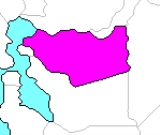
. It is located entirely in and covers most of Contra Costa County
. This includes all of the central and eastern portions of the county (everything east of Alameda County
), and the western portion of the county on San Pablo Bay.
Census-designated place
s
and Livermore
was removed and a portion of Richmond added.
California
California is a state located on the West Coast of the United States. It is by far the most populous U.S. state, and the third-largest by land area...
's 7th State Senate
California State Senate
The California State Senate is the upper house of the California State Legislature. There are 40 state senators. The state legislature meets in the California State Capitol in Sacramento. The Lieutenant Governor is the ex officio President of the Senate and may break a tied vote...
District is one of 40 Senate Districts. It is currently represented by Democrat
California Democratic Party
The California Democratic Party is the state branch of the Democratic Party in the state of California, headquartered in Sacramento. It is chaired by veteran Democratic politician and former United States Representative John L. Burton, who succeeded Art Torres in April 2009. It is the majority...
Mark DeSaulnier
Mark DeSaulnier
Mark James DeSaulnier is an American politician and a Democratic member of the California Legislature representing California's 7th State Senate district since December 2008. From 2006 to 2008, DeSaulnier represented California's 11th State Assembly district...
of Concord
Concord, California
Concord is the largest city in Contra Costa County, California, USA. At the 2010 census, the city had a population of 122,067. Originally founded in 1869 as the community of Todos Santos by Salvio Pacheco, the name was changed to Concord within months...
.
District profile
The 7th District includes a predominantly suburban portion of the East BayEast Bay (San Francisco Bay Area)
The East Bay is a commonly used, informal term for the lands on the eastern side of the San Francisco Bay, in the San Francisco Bay Area, in California, United States...
. It is located entirely in and covers most of Contra Costa County
Contra Costa County, California
Contra Costa County is a primarily suburban county in the San Francisco Bay Area of the U.S. state of California. As of the 2010 census, it had a population of 1,049,025...
. This includes all of the central and eastern portions of the county (everything east of Alameda County
Alameda County, California
Alameda County is a county in the U.S. state of California. It occupies most of the East Bay region of the San Francisco Bay Area. As of the 2010 census it had a population of 1,510,271, making it the 7th most populous county in the state...
), and the western portion of the county on San Pablo Bay.
Communities represented
Cities- AntiochAntioch, CaliforniaAntioch is a city in Contra Costa County, California. Located in the East Bay region of the San Francisco Bay Area along the San Joaquin-Sacramento River Delta, it is a suburb of San Francisco and Oakland. The city's population was 102,372 at the U.S...
- BrentwoodBrentwood, CaliforniaBrentwood is a city in Contra Costa County, California, United States. It is located in the East Bay region of the San Francisco Bay Area. The population is 51,481 as of 2010....
- ClaytonClayton, CaliforniaClayton is a city in Contra Costa County, California, United States. The population was 10,897 as of the 2010 census.- Geography :...
- ConcordConcord, CaliforniaConcord is the largest city in Contra Costa County, California, USA. At the 2010 census, the city had a population of 122,067. Originally founded in 1869 as the community of Todos Santos by Salvio Pacheco, the name was changed to Concord within months...
- DanvilleDanville, CaliforniaThe Town of Danville is located in the San Ramon Valley in Contra Costa County, California. It is one of the incorporated municipalities in California that uses "town" in its name instead of "city". The population was 42,039 in 2010. Danville is one of the wealthiest suburbs of Oakland and San...
- El CerritoEl Cerrito, Contra Costa County, California-Transportation:The city's primary transportation infrastructure consists of the El Cerrito Plaza and El Cerrito del Norte BART stations along with several local bus lines, operated by AC Transit, providing access to the surrounding area and the nearby cities of Albany, Berkeley and Richmond...
- HerculesHercules, CaliforniaHercules is a city in western Contra Costa County, California. Situated along the coast of San Pablo Bay, it is located in the eastern region of the San Francisco Bay Area, about northeast of San Francisco. The city has a 2010 population of 24,060 according to the U.S...
- LafayetteLafayette, CaliforniaLafayette is a city in Contra Costa County, California, United States. As of the 2010 census, the city's population was 23,893. It was named after the Marquis de Lafayette, a French military hero of the American Revolutionary War...
- MartinezMartinez, CaliforniaMartinez is a city and the county seat of Contra Costa County, California, United States. The population was 35,824 at the 2010 census. The downtown is notable for its large number of preserved old buildings...
- MoragaMoraga, CaliforniaMoraga is a suburban incorporated town located in Contra Costa County, California, United States, in the San Francisco Bay Area. It is named in honor of Joaquin Moraga, whose grandfather was José Joaquin Moraga, second in command to Juan Bautista de Anza...
- OakleyOakley, CaliforniaOakley is a city in Contra Costa County, California, United States. The population was 35,432 at the 2010 U.S. Census. Oakley is part of the East Contra Costa Bicycle Plan, which has existing facilities in Oakley as well as plans for further expansion....
- OrindaOrinda, California-2010:The 2010 United States Census reported that Orinda had a population of 17,643. The population density was 1,389.5 people per square mile . The racial makeup of Orinda was 14,533 White, 149 African American, 22 Native American, 2,016 Asian, 24 Pacific Islander, 122 from other races, and...
- PinolePinole, CaliforniaPinole is a city in Contra Costa County, California, United States. The population was 18,390 at the 2010 census. It is one of many small “bedroom communities” along the I-80 corridor in Western Contra Costa County. It is located about northeast of San Francisco, and approximately a half-hour...
- PittsburgPittsburg, CaliforniaPittsburg is a city located in eastern Contra Costa County, California, the outer portion of the East Bay region of the San Francisco Bay Area. The population was 63,264 at the 2010 census....
- Pleasant HillPleasant Hill, CaliforniaPleasant Hill is a city in Contra Costa County, California, United States, in the East Bay of the San Francisco Bay Area. The population was 33,152 at the 2010 census. It was incorporated in 1961...
- RichmondRichmond, CaliforniaRichmond is a city in western Contra Costa County, California, United States. The city was incorporated on August 7, 1905. It is located in the East Bay, part of the San Francisco Bay Area. It is a residential inner suburb of San Francisco, as well as the site of heavy industry, which has been...
(one-third of its residents; the rest are in Senate District 9) - San RamonSan Ramon, California-2010 census:The 2010 United States Census reported that San Ramon had a population of 72,148. The population density was 3,991.1 people per square mile...
- Walnut CreekWalnut Creek, CaliforniaWalnut Creek is an incorporated city located east of the city of Oakland. It lies in the East Bay region of the San Francisco Bay Area. While not as large as neighboring Concord, Walnut Creek serves as the business and entertainment hub for the neighboring cities within central Contra Costa...
Census-designated place
Census-designated place
A census-designated place is a concentration of population identified by the United States Census Bureau for statistical purposes. CDPs are delineated for each decennial census as the statistical counterparts of incorporated places such as cities, towns and villages...
s
- AlamoAlamo, CaliforniaAlamo is an unincorporated community and census-designated place in Contra Costa County, California, in the United States. It is located in the East Bay region of the San Francisco Bay Area...
- Bay PointBay Point, CaliforniaBay Point, formerly West Pittsburg, is a suburb and census-designated place located in eastern Contra Costa County, California, just west of the city of Pittsburg and northeast over a low range of hills from Concord...
- Bayview-MontalvinBayview-Montalvin, CaliforniaBayview-Montalvin is a former census-designated place in Contra Costa County, California, United States. The population was 5,004 at the 2000 census.Prior to the 2010 census, the CDP was dissolved into Bayview CDP and Montalvin Manor CDP.-Geography:...
- Bethel IslandBethel Island, CaliforniaBethel Island is a census-designated place on Bethel Island in Contra Costa County, California, United States. The population was 2,137 at the 2010 census.-Geography:...
- Blackhawk-Camino TassajaraBlackhawk-Camino Tassajara, CaliforniaBlackhawk-Camino Tassajara is a former census-designated place in Contra Costa County, California, near the town of Danville. The unincorporated area consisted of the Blackhawk country club area and the surrounding Camino Tassajara area. As of the 2000 census, the CDP's population was 10,048...
- ByronByron, CaliforniaByron is a census-designated place in Contra Costa County, California, United States. The population was 1,277 at the 2010 census.-Geography:...
- ClydeClyde, CaliforniaClyde is a census-designated place in Contra Costa County, California, United States. The population was 678 at the 2010 census. It is located east of Martinez.-Geography:...
- CrockettCrockett, CaliforniaCrockett is a census-designated place in Contra Costa County, California, United States. The population was 3,094 at the 2010 census...
- DiabloDiablo, CaliforniaDiablo is a census-designated place in Contra Costa County, California, United States. The population was 1,158 at the 2010 census. It is located east-northeast of Danville...
- Discovery BayDiscovery Bay, CaliforniaDiscovery Bay is a census-designated place in extreme eastern Contra Costa County, California in the United States about from San Francisco. As of 2010, its population was 13,352....
- East Richmond HeightsEast Richmond Heights, CaliforniaEast Richmond Heights is an unincorporated and census-designated place in western Contra Costa County, California, United States. The community is locally referred to as Richmond View or Arlington Heights, especially in the context of real estate advertisements...
- El SobranteEl Sobrante, CaliforniaEl Sobrante is a census-designated place in Contra Costa County, California, United States. The population was 12,669 at the 2010 census...
- KensingtonKensington, CaliforniaKensington is an unincorporated community and census-designated place located in the East Bay, part of the San Francisco Bay Area, in Contra Costa County, California, United States. The population was 5,077 at the 2010 census.- Law and government :Kensington is an unincorporated area of Contra...
- KnightsenKnightsen, CaliforniaKnightsen is a census-designated place in Contra Costa County, California, in the United States. As of the 2010 census, the CDP population was 1,568, up from 861 reported in the 2000 census.-Geography:...
- Mountain ViewMountain View, California-Downtown:Mountain View has a pedestrian-friendly downtown centered on Castro Street. The downtown area consists of the seven blocks of Castro Street from the Downtown Mountain View Station transit center in the north to the intersection with El Camino Real in the south...
- Pacheco
- Port CostaPort Costa, CaliforniaPort Costa is a census-designated place in Contra Costa County, California, United States. The population was 190 at the 2010 census.-Geography:...
- RodeoRodeo, CaliforniaRodeo is a census-designated place located in Contra Costa County, California on the shore of San Pablo Bay. The population was 8,679 at the 2010 census. The town is named for the livestock roundups common in the late 19th century...
- RollingwoodRollingwood, CaliforniaRollingwood is a census-designated place in Contra Costa County, California, United States. As of the 2010 census, Rollingwood's population was 2,969.-Geography:...
- Tara HillsTara Hills, CaliforniaTara Hills is a census-designated place in Contra Costa County, California, United States. The population was 5,126 at the 2010 census.-Geography:According to the United States Census Bureau, the CDP has a total area of , all of it land....
- Vine HillVine Hill, CaliforniaVine Hill is a census-designated place in Contra Costa County, California, United States. The population was 3,761 at the 2010 census. It is located east of downtown Martinez.-Geography:...
- WaldonWaldon, CaliforniaWaldon is a former census-designated place in Contra Costa County, California, United States. The population was 5,133 at the 2000 census. The Pittsburg/Bay Point – SFO Line line of the Bay Area Rapid Transit system serves the surrounding area using the Pleasant Hill/Contra Costa Centre Station...
2004
2000
2001 Redistricting
The 7th is almost identical to the district in the 1990s. In 2001, the Alameda County portion of the district in DublinDublin, California
Dublin is a suburban city of the East Bay region of Alameda County, California, United States. Located along the north side of Interstate 580 at the intersection with Interstate 680, roughly east of Hayward, west of Livermore and north of San Jose, it was named after the city of Dublin in...
and Livermore
Livermore, California
Livermore is a city in Alameda County. The population as of 2010 was 80,968. Livermore is located on the eastern edge of California's San Francisco Bay Area....
was removed and a portion of Richmond added.