
Caldecote, Cambridgeshire
Encyclopedia
Caldecote is a village in Cambridgeshire
, in the district of South Cambridgeshire
. It is located south of the A428
, approximately six miles west of Cambridge
and three miles east of Cambourne
.
Nearby settlements are Hardwick
and Toft
to the east, Bourn
to the west, Childerley
to the north and Kingston
to the south. Bourn Airfield lies on the north-west edge of the village.
and the route of the former Oxford and Cambridge Railway
runs to the south of the village.
petrol station is located just outside Highfields on the former A428 road at Childerley Gate. The A428 was converted to a dual carriageway and was opened on 24 May 2007, allowing easy access.
Cambridgeshire
Cambridgeshire is a county in England, bordering Lincolnshire to the north, Norfolk to the northeast, Suffolk to the east, Essex and Hertfordshire to the south, and Bedfordshire and Northamptonshire to the west...
, in the district of South Cambridgeshire
South Cambridgeshire
South Cambridgeshire is a mostly rural local government district of Cambridgeshire, England. It was formed on 1 April 1974 by the merger of Chesterton Rural District and South Cambridgeshire Rural District. It surrounds the city of Cambridge, which is administered separately from the district by...
. It is located south of the A428
A428 road
The A428 road is a major road in central and eastern England. It connects the cities of Coventry and Cambridge by way of the county towns of Northampton and Bedford.-Coventry - Northampton:...
, approximately six miles west of Cambridge
Cambridge
The city of Cambridge is a university town and the administrative centre of the county of Cambridgeshire, England. It lies in East Anglia about north of London. Cambridge is at the heart of the high-technology centre known as Silicon Fen – a play on Silicon Valley and the fens surrounding the...
and three miles east of Cambourne
Cambourne
Cambourne is a new settlement and civil parish in Cambridgeshire, England, in the district of South Cambridgeshire. It lies on the A428 road between Cambridge, 9 miles to the east, and St Neots and Bedford to the west. It comprises the three villages of Great Cambourne, Lower Cambourne and Upper...
.
Nearby settlements are Hardwick
Hardwick, Cambridgeshire
Hardwick is a village in the county of Cambridgeshire, England with a large housing estate located about west of the city of Cambridge and immediately south of the A428 Cambridge-St Neots road. It is about east of the newly developed village of Cambourne. The Village is nearly on the Greenwich...
and Toft
Toft, Cambridgeshire
Toft is a village situated in Cambridgeshire, England. It is approximately six miles to the west of Cambridge, and is situated within four miles of the M11 motorway. It has approximately 600 residents and 200 homes. Comberton Village College falls within the Toft Parish boundary...
to the east, Bourn
Bourn
Bourn is a small village and civil parish in South Cambridgeshire, England. Surrounding villages include Caxton, Eltisley and Cambourne. It is 8 miles from the county town of Cambridge. The population of the parish was 1,764 people at the time of the 2001 census.Bourn has a Church of England...
to the west, Childerley
Childerley
Childerley, also known as Great Childerley and Little Childerly, was a small rural village in the county of Cambridgeshire in the East of England, United Kingdom.-Village history:...
to the north and Kingston
Kingston, Cambridgeshire
Kingston is a small village and parish in the East of England region and the county Cambridgeshire in the United Kingdom. Situated 7 miles to the west of Cambridge, the population at the time of the 2001 census was 214....
to the south. Bourn Airfield lies on the north-west edge of the village.
History
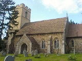
The older part of the village lies to the south, just off the B1046 road and is mentioned in the Domesday Book of 1086. The parish church, St. Michael and All Angels, parts of which date to the 14th Century, is located in this part of the village. Bourn BrookBourn Brook, Cambridgeshire
Bourn Brook is a minor tributary of the River Cam in Cambridgeshire, England.It has its source just to the east of the village of Eltisley, 10 miles west of Cambridge, where the hills rise to around 60 metres above sea level...
and the route of the former Oxford and Cambridge Railway
Varsity Line
The Varsity Line is an informal name for the railway route that formerly linked the English university cities of Oxford and Cambridge, operated successively by the London and North Western Railway, the London, Midland and Scottish Railway, and British Railways...
runs to the south of the village.
Highfields Caldecote
Highfields Caldecote is a newer development in the north of the village, where there is a social club and a primary school. The village hall is situated next to the school and was built in 1998, replacing an older building next to the social club. Further development in Highfields since 2000 has led to the construction of a village shop, an extension to the school, a recreation ground and a hairdressing salon. A BPBP
BP p.l.c. is a global oil and gas company headquartered in London, United Kingdom. It is the third-largest energy company and fourth-largest company in the world measured by revenues and one of the six oil and gas "supermajors"...
petrol station is located just outside Highfields on the former A428 road at Childerley Gate. The A428 was converted to a dual carriageway and was opened on 24 May 2007, allowing easy access.