
Cajon Pass
Encyclopedia
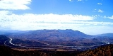
Cajon Pass is a moderate-elevation mountain pass
between the San Bernardino Mountains
and the San Gabriel Mountains
in Southern California
in the United States
. It was created by the movements of the San Andreas Fault
. The Mojave Desert
pass provides an important economic link from the Greater San Bernardino Area, in the Los Angeles metropolitan area
, to Victor Valley, and northeast to Las Vegas
.
Cajon Pass itself, located at 34°19′33"N 117°25′42"W, is at the head of Horsethief Canyon traversed by California State Route 138
(SR 138) and railroad tracks owned by BNSF Railway
and Union Pacific Railroad
. Railroad improvements in 1972 reduced its maximum elevation from about 3829 feet (1,167.1 m) to 3777 feet (1,151.2 m) while also reducing the curvature.
Interstate 15
does not traverse Cajon Pass itself but rather the nearby Cajon Summit, 34°20′58"N 117°26′47"W, elevation 4190 feet (1,277.1 m). However, the entire area including Cajon Pass and Cajon Summit is often collectively referred to as Cajon Pass. Sometimes the entire area is called Cajon Pass but a distinction is made between Cajon Pass and Cajon Summit in detail.
 In 1851, a group of Mormon
settlers led by Amasa M. Lyman and Charles C. Rich
traveled through the Cajon Pass in covered wagon
s on their way from Salt Lake City to Southern California. A prominent rock formation in the pass, where the Mormon trail and the railway merge (at 34.3184,-117.4920, near Sullivan's Curve), is known as Mormon Rocks.
The weather over the pass can vary, from foggy days with poor visibility to clear afternoons where aircraft are bounced by gusting Santa Ana winds that top 80 mph (35.8 m/s). The wind in this area is predominantly out of the west, although in Santa Ana and other weather conditions it may be out of the north or the southeast. Air spilling over the San Gabriels can cause fairly violent up- and downdrafts. On a normal day, with the wind out of the west, turbulence
usually starts a few miles west of Rialto
and continues a few miles to the east, growing in strength above the altitude of the mountains and especially over the pass itself near the HITOP VFR
intersection. In Santa Ana conditions, up- and downdrafts can become especially violent northeast of Ontario Airport, and turbulence can be experienced all the way east to the Banning Pass (itself known for turbulence.) It's important to note that the mass and wing loading
of an aircraft determines its sensitivity to turbulence, so what may seem violent in a Cessna 172
may seem only mild to moderate in a Boeing 747
. In the 2006 Mercy Air 2 accident, an air ambulance
helicopter collided with mountainous terrain near the pass in foggy weather.
 The California Southern Railroad
, a subsidiary
of the Atchison, Topeka and Santa Fe Railway
, was the first railroad to use the Cajon Pass as a route through the mountains. The rail line through the pass was built in the early 1880s as part of a connection between the present day cities of Barstow
and San Diego
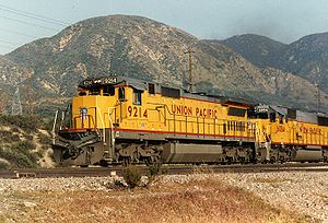
. Today, the Union Pacific Railroad
and BNSF Railway
(the successor to the Santa Fe) use this pass to access Los Angeles and San Bernardino. Due to the high volume of trains, noteworthy scenery and easy access, it is a popular location for railfan
ning, and numerous photographs of trains on Cajon Pass appear in books and magazines about trains. The current Amtrak
Chicago-Los Angeles Southwest Chief
passenger train travels through the pass.
The Union Pacific Railroad operates and owns one track through the pass, on the previous Southern Pacific Railroad Palmdale cutoff, opened in 1967. The BNSF Railway had two tracks and began to operate a third main track in the summer of 2008. The railroads share track rights through the pass ever since the Union Pacific gained track rights on the Santa Fe portion negotiated under the original Los Angeles and Salt Lake Railroad
. The original BNSF (ATSF) line was constructed in 1890 and later roads, U.S. Route 66
and I-15, roughly followed this route. The 3.0% grade for a few miles on the south track is especially challenging for long trains, making the westbound descent potentially dangerous, as a runaway can easily occur if the engineer is not careful in handling the brakes.
The second track, built in 1913, makes a 2 miles (3.2 km) loop around the hills at a lower 2.20% grade. It ran through two short tunnels, but both were removed in order to add the third main track that runs parallel to the 1913 line. Speeds of 60 mile per hour may be seen on the straighter track away from the pass, but are typically 14 mile per hour ascending and between 20 mile per hour while descending. The third track enables a capacity of 150 trains per day on the BNSF lines.
Cajon Pass was the site of a major train accident on 14 December 1994, when a westbound Atchison, Topeka & Santa Fe intermodal train lost control in the Cajon Pass and crashed into the rear of a westbound Southern Pacific coal train just below California Highway 138 between Alray and Cajon. The steep downhill grade south of the pass had earlier been a contributing factor in the 12 May 1989 San Bernardino train disaster
.
The historic Summit Inn
, off the Oak Hills exit at the summit of the pass, is a historic Route 66 diner and has been at its present location since 1952. Some maps may show the Cajon Pass as a feature on SR 138, which crosses I-15 south of the summit between West Cajon Valley and Summit Valley. The highest point on I-15 between Los Angeles and Victorville is thus sometimes identified as Cajon Summit. However, the entire area, including Cajon Summit, is often called Cajon Pass.
goes directly through Cajon Pass, and during the hiking season up to several hundred thru-hikers will pass through this area after walking one of the hottest, driest, and most grueling sections of desert on the trail. The McDonalds restaurant at the pass happens to be very close to the trail, and it is famous among thru-hikers (who often arrive dehydrated), and most will stop here for water and salty food. Many hikers also spend the night in one of the motels at Cajon Pass.
500 kV
power line
s cross the summit as well. These power lines head to the Lugo substation
northeast of Cajon Pass and connect to Path 26
and Path 46
. Both Path 26 and 46 provide the Los Angeles metro area another source of electricity generated from fossil fuel power plants in the Four Corners region, and hydroelectric dams along the Colorado River
.
to further close the freeway pass.
In addition to wildfire hazards, Cajon Pass is notorious for wind hazards. In gusty conditions it is especially difficult to navigate through it as the Santa Ana winds usually push through that area. The winds sometimes reach gale-force strength. As a result, there are usually high wind advisories as well as road signs posted throughout the area. It is not uncommon to see overturned trucks during such windy weather there.
Cajon Pass gets snow occasionally, sometimes enough to close the pass temporarily. When there is snow, the California Highway Patrol
will set up checkpoints on the freeway. Since most Southern Californians are without snow tires or snow chains, they are forced to turn back, or wait until the snow has stopped and the freeway has been cleared of snow.
When there is high wind or snow in the Cajon Pass, it is fairly common for weather forecasters or reporters for San Bernardino, San Diego, and Los Angeles-area televisions stations to do location
reports from the Cajon Pass.
The San Andreas Fault
passes through the Cajon Pass (crossing I-15 on the south side of the summit) and is responsible for the unique local geography.
Mountain pass
A mountain pass is a route through a mountain range or over a ridge. If following the lowest possible route, a pass is locally the highest point on that route...
between the San Bernardino Mountains
San Bernardino Mountains
The San Bernardino Mountains are a short transverse mountain range north and east of San Bernardino in Southern California in the United States. The mountains run for approximately 60 miles east-west on the southern edge of the Mojave Desert in southwestern San Bernardino County, north of the...
and the San Gabriel Mountains
San Gabriel Mountains
The San Gabriel Mountains Range is located in northern Los Angeles County and western San Bernardino County, California, United States. The mountain range lies between the Los Angeles Basin and the Mojave Desert, with Interstate 5 to the west and Interstate 15 to the east...
in Southern California
Southern California
Southern California is a megaregion, or megapolitan area, in the southern area of the U.S. state of California. Large urban areas include Greater Los Angeles and Greater San Diego. The urban area stretches along the coast from Ventura through the Southland and Inland Empire to San Diego...
in the United States
United States
The United States of America is a federal constitutional republic comprising fifty states and a federal district...
. It was created by the movements of the San Andreas Fault
San Andreas Fault
The San Andreas Fault is a continental strike-slip fault that runs a length of roughly through California in the United States. The fault's motion is right-lateral strike-slip...
. The Mojave Desert
Mojave Desert
The Mojave Desert occupies a significant portion of southeastern California and smaller parts of central California, southern Nevada, southwestern Utah and northwestern Arizona, in the United States...
pass provides an important economic link from the Greater San Bernardino Area, in the Los Angeles metropolitan area
Los Angeles Metropolitan Area
The Los Angeles metropolitan area, also known as Metropolitan Los Angeles or the Southland, is the 13th largest metropolitan area in the world and the second-largest metropolitan area in the United States....
, to Victor Valley, and northeast to Las Vegas
Las Vegas metropolitan area
The Las Vegas Valley is the heart of the Las Vegas-Paradise, NV MSA also known as the Las Vegas–Paradise–Henderson MSA which includes all of Clark County, Nevada, and is a metropolitan area in the southern part of the U.S. state of Nevada. The Valley is defined by the Las Vegas Valley landform, a ...
.
Cajon Pass itself, located at 34°19′33"N 117°25′42"W, is at the head of Horsethief Canyon traversed by California State Route 138
California State Route 138
State Route 138 is an east–west state highway generally following the northern foothills of the San Gabriel Mountains of southern California, USA from its junction with Interstate 5 south of Gorman eastward to Mount Anderson Junction, its eastern junction with State Route 18 south of...
(SR 138) and railroad tracks owned by BNSF Railway
BNSF Railway
The BNSF Railway is a wholly owned subsidiary of Berkshire Hathaway Inc., and is headquartered in Fort Worth, Texas. It is one of seven North American Class I railroads and the second largest freight railroad network in North America, second only to the Union Pacific Railroad, its primary...
and Union Pacific Railroad
Union Pacific Railroad
The Union Pacific Railroad , headquartered in Omaha, Nebraska, is the largest railroad network in the United States. James R. Young is president, CEO and Chairman....
. Railroad improvements in 1972 reduced its maximum elevation from about 3829 feet (1,167.1 m) to 3777 feet (1,151.2 m) while also reducing the curvature.
Interstate 15
Interstate 15
Interstate 15 is the fourth-longest north–south Interstate Highway in the United States, traveling through the states of California, Nevada, Arizona, Utah, Idaho, and Montana from San Diego to the Canadian border...
does not traverse Cajon Pass itself but rather the nearby Cajon Summit, 34°20′58"N 117°26′47"W, elevation 4190 feet (1,277.1 m). However, the entire area including Cajon Pass and Cajon Summit is often collectively referred to as Cajon Pass. Sometimes the entire area is called Cajon Pass but a distinction is made between Cajon Pass and Cajon Summit in detail.
Mormon
The term Mormon most commonly denotes an adherent, practitioner, follower, or constituent of Mormonism, which is the largest branch of the Latter Day Saint movement in restorationist Christianity...
settlers led by Amasa M. Lyman and Charles C. Rich
Charles C. Rich
Charles Coulson Rich was an early leader in the Latter Day Saint movement and served as an apostle of The Church of Jesus Christ of Latter-day Saints ....
traveled through the Cajon Pass in covered wagon
Covered wagon
The covered wagon, also known as a Prairie schooner, is an icon of the American Old West.Although covered wagons were commonly used for shorter moves within the United States, in the mid-nineteenth century thousands of Americans took them across the Great Plains to Oregon and California...
s on their way from Salt Lake City to Southern California. A prominent rock formation in the pass, where the Mormon trail and the railway merge (at 34.3184,-117.4920, near Sullivan's Curve), is known as Mormon Rocks.
Aviation
The Cajon Pass area is known for high wind, turbulence and fog.The weather over the pass can vary, from foggy days with poor visibility to clear afternoons where aircraft are bounced by gusting Santa Ana winds that top 80 mph (35.8 m/s). The wind in this area is predominantly out of the west, although in Santa Ana and other weather conditions it may be out of the north or the southeast. Air spilling over the San Gabriels can cause fairly violent up- and downdrafts. On a normal day, with the wind out of the west, turbulence
Turbulence
In fluid dynamics, turbulence or turbulent flow is a flow regime characterized by chaotic and stochastic property changes. This includes low momentum diffusion, high momentum convection, and rapid variation of pressure and velocity in space and time...
usually starts a few miles west of Rialto
Rialto, California
-2010:The 2010 United States Census reported that Rialto had a population of 99,171. The population density was 4,434.1 people per square mile . The racial makeup of Rialto was 43,592 White, 16,236 African American, 1,062 Native American, 2,258 Asian, 361 Pacific Islander, 30,993 from other...
and continues a few miles to the east, growing in strength above the altitude of the mountains and especially over the pass itself near the HITOP VFR
Visual flight rules
Visual flight rules are a set of regulations which allow a pilot to operate an aircraft in weather conditions generally clear enough to allow the pilot to see where the aircraft is going. Specifically, the weather must be better than basic VFR weather minimums, as specified in the rules of the...
intersection. In Santa Ana conditions, up- and downdrafts can become especially violent northeast of Ontario Airport, and turbulence can be experienced all the way east to the Banning Pass (itself known for turbulence.) It's important to note that the mass and wing loading
Wing loading
In aerodynamics, wing loading is the loaded weight of the aircraft divided by the area of the wing. The faster an aircraft flies, the more lift is produced by each unit area of wing, so a smaller wing can carry the same weight in level flight, operating at a higher wing loading. Correspondingly,...
of an aircraft determines its sensitivity to turbulence, so what may seem violent in a Cessna 172
Cessna 172
The Cessna 172 Skyhawk is a four-seat, single-engine, high-wing fixed-wing aircraft. First flown in 1955 and still in production, more Cessna 172s have been built than any other aircraft.-Design and development:...
may seem only mild to moderate in a Boeing 747
Boeing 747
The Boeing 747 is a wide-body commercial airliner and cargo transport, often referred to by its original nickname, Jumbo Jet, or Queen of the Skies. It is among the world's most recognizable aircraft, and was the first wide-body ever produced...
. In the 2006 Mercy Air 2 accident, an air ambulance
Air ambulance
An air ambulance is an aircraft used for emergency medical assistance in situations where either a traditional ambulance cannot reach the scene easily or quickly enough, or the patient needs to be transported over a distance or terrain that makes air transportation the most practical transport....
helicopter collided with mountainous terrain near the pass in foggy weather.
Rail transport
California Southern Railroad
The California Southern Railroad was a subsidiary railroad of the Atchison, Topeka and Santa Fe Railway in Southern California. It was organized July 10, 1880, and chartered on October 23, 1880, to build a rail connection between what has become the city of Barstow and San Diego,...
, a subsidiary
Subsidiary
A subsidiary company, subsidiary, or daughter company is a company that is completely or partly owned and wholly controlled by another company that owns more than half of the subsidiary's stock. The subsidiary can be a company, corporation, or limited liability company. In some cases it is a...
of the Atchison, Topeka and Santa Fe Railway
Atchison, Topeka and Santa Fe Railway
The Atchison, Topeka and Santa Fe Railway , often abbreviated as Santa Fe, was one of the larger railroads in the United States. The company was first chartered in February 1859...
, was the first railroad to use the Cajon Pass as a route through the mountains. The rail line through the pass was built in the early 1880s as part of a connection between the present day cities of Barstow
Barstow, California
Barstow is a city in San Bernardino County, California, United States. The population was 22,639 at the 2010 census, up from 21,119 at the 2000 census. Barstow is located north of San Bernardino....
and San Diego
San Diego, California
San Diego is the eighth-largest city in the United States and second-largest city in California. The city is located on the coast of the Pacific Ocean in Southern California, immediately adjacent to the Mexican border. The birthplace of California, San Diego is known for its mild year-round...
. Today, the Union Pacific Railroad
Union Pacific Railroad
The Union Pacific Railroad , headquartered in Omaha, Nebraska, is the largest railroad network in the United States. James R. Young is president, CEO and Chairman....
and BNSF Railway
BNSF Railway
The BNSF Railway is a wholly owned subsidiary of Berkshire Hathaway Inc., and is headquartered in Fort Worth, Texas. It is one of seven North American Class I railroads and the second largest freight railroad network in North America, second only to the Union Pacific Railroad, its primary...
(the successor to the Santa Fe) use this pass to access Los Angeles and San Bernardino. Due to the high volume of trains, noteworthy scenery and easy access, it is a popular location for railfan
Railfan
A railfan or rail buff , railway enthusiast or railway buff , or trainspotter , is a person interested in a recreational capacity in rail transport...
ning, and numerous photographs of trains on Cajon Pass appear in books and magazines about trains. The current Amtrak
Amtrak
The National Railroad Passenger Corporation, doing business as Amtrak , is a government-owned corporation that was organized on May 1, 1971, to provide intercity passenger train service in the United States. "Amtrak" is a portmanteau of the words "America" and "track". It is headquartered at Union...
Chicago-Los Angeles Southwest Chief
Southwest Chief
The Southwest Chief is a passenger train operated by Amtrak on a 2256-mile BNSF route through the Midwestern and Southwestern United States. It runs from Chicago, Illinois, to Los Angeles, California, passing through Illinois, Iowa, Missouri, Kansas, Colorado, New Mexico, Arizona, and California...
passenger train travels through the pass.
The Union Pacific Railroad operates and owns one track through the pass, on the previous Southern Pacific Railroad Palmdale cutoff, opened in 1967. The BNSF Railway had two tracks and began to operate a third main track in the summer of 2008. The railroads share track rights through the pass ever since the Union Pacific gained track rights on the Santa Fe portion negotiated under the original Los Angeles and Salt Lake Railroad
Los Angeles and Salt Lake Railroad
The Los Angeles and Salt Lake Railroad was a rail company that completed and operated a railway line between its namesake cities, via Las Vegas, Nevada. Incorporated in Utah in 1901 as the San Pedro, Los Angeles and Salt Lake Railroad, the line was largely the brainchild of William Andrews Clark,...
. The original BNSF (ATSF) line was constructed in 1890 and later roads, U.S. Route 66
U.S. Route 66
U.S. Route 66 was a highway within the U.S. Highway System. One of the original U.S. highways, Route 66 was established on November 11, 1926 -- with road signs erected the following year...
and I-15, roughly followed this route. The 3.0% grade for a few miles on the south track is especially challenging for long trains, making the westbound descent potentially dangerous, as a runaway can easily occur if the engineer is not careful in handling the brakes.
The second track, built in 1913, makes a 2 miles (3.2 km) loop around the hills at a lower 2.20% grade. It ran through two short tunnels, but both were removed in order to add the third main track that runs parallel to the 1913 line. Speeds of 60 mile per hour may be seen on the straighter track away from the pass, but are typically 14 mile per hour ascending and between 20 mile per hour while descending. The third track enables a capacity of 150 trains per day on the BNSF lines.
Cajon Pass was the site of a major train accident on 14 December 1994, when a westbound Atchison, Topeka & Santa Fe intermodal train lost control in the Cajon Pass and crashed into the rear of a westbound Southern Pacific coal train just below California Highway 138 between Alray and Cajon. The steep downhill grade south of the pass had earlier been a contributing factor in the 12 May 1989 San Bernardino train disaster
San Bernardino train disaster
The San Bernardino Train Disaster, sometimes known as the Duffy Street Incident, is a combination of two separate but related incidents which occurred in San Bernardino, California: A runaway train derailment on May 12, 1989, and the subsequent failure on May 25, 1989, of a petroleum pipeline...
.
Road transport
The Mojave Freeway (I-15) was built in 1969 over the Cajon Summit west of the Cajon Pass. It is a major route from Los Angeles and the Inland Empire to Las Vegas. The freeway runs above and parallel to an original stretch of historic Route 66 and 395. This stretch, which is now known as Cajon Boulevard, is a short but well-preserved fragment dating back to a rerouting and widening of the highway in the early 1950s. Only the southbound/westbound lanes are in use; the northbound/eastbound lanes and corresponding bridges are closed to through traffic. It is along this stretch of road, accessible via either the Kenwood Drive or Cleghorn Road exits that some of the best aforementioned trainspotting areas may be found.The historic Summit Inn
Summit Inn
The Summit Inn is a historic U.S. Route 66 roadside diner and one of the few of its kind left in Southern California.So named because its original location was at the summit of the Cajon Pass between the westbound and eastbound lanes of US 66, the present location in unincorporated Oak Hills,...
, off the Oak Hills exit at the summit of the pass, is a historic Route 66 diner and has been at its present location since 1952. Some maps may show the Cajon Pass as a feature on SR 138, which crosses I-15 south of the summit between West Cajon Valley and Summit Valley. The highest point on I-15 between Los Angeles and Victorville is thus sometimes identified as Cajon Summit. However, the entire area, including Cajon Summit, is often called Cajon Pass.
Pacific Crest Trail
The Pacific Crest TrailPacific Crest Trail
The Pacific Crest Trail is a long-distance mountain hiking and equestrian trail on the Western Seaboard of the United States. The southern terminus is at the California border with Mexico...
goes directly through Cajon Pass, and during the hiking season up to several hundred thru-hikers will pass through this area after walking one of the hottest, driest, and most grueling sections of desert on the trail. The McDonalds restaurant at the pass happens to be very close to the trail, and it is famous among thru-hikers (who often arrive dehydrated), and most will stop here for water and salty food. Many hikers also spend the night in one of the motels at Cajon Pass.
Utilities infrastructure
In addition to transportation infrastructure, three high voltage Southern California EdisonSouthern California Edison
Southern California Edison , the largest subsidiary of Edison International , is the primary electricity supply company for much of Southern California, USA. It provides 14 million people with electricity...
500 kV
Volt
The volt is the SI derived unit for electric potential, electric potential difference, and electromotive force. The volt is named in honor of the Italian physicist Alessandro Volta , who invented the voltaic pile, possibly the first chemical battery.- Definition :A single volt is defined as the...
power line
Electric power transmission
Electric-power transmission is the bulk transfer of electrical energy, from generating power plants to Electrical substations located near demand centers...
s cross the summit as well. These power lines head to the Lugo substation
Electrical substation
A substation is a part of an electrical generation, transmission, and distribution system. Substations transform voltage from high to low, or the reverse, or perform any of several other important functions...
northeast of Cajon Pass and connect to Path 26
Path 26
Path 26 is a set of three Southern California Edison 500 kV power lines, located primarily in Los Angeles County, and extending into Kern and Ventura Counties, all in California...
and Path 46
Path 46
Path 46, also called West of Colorado River, Arizona-California West-of-the-River Path , is a set of many alternating current high-voltage transmission lines that are located in southeast California and Nevada up to the Colorado River...
. Both Path 26 and 46 provide the Los Angeles metro area another source of electricity generated from fossil fuel power plants in the Four Corners region, and hydroelectric dams along the Colorado River
Colorado River
The Colorado River , is a river in the Southwestern United States and northwestern Mexico, approximately long, draining a part of the arid regions on the western slope of the Rocky Mountains. The watershed of the Colorado River covers in parts of seven U.S. states and two Mexican states...
.
Natural hazards
During October and November 2003, a number of wildfires devastated the hills and mountainsides near and around the pass, forcing the closure of Interstate 15. The following winter, rains in addition to burnt vegetation caused a number of landsidesLandslide
A landslide or landslip is a geological phenomenon which includes a wide range of ground movement, such as rockfalls, deep failure of slopes and shallow debris flows, which can occur in offshore, coastal and onshore environments...
to further close the freeway pass.
In addition to wildfire hazards, Cajon Pass is notorious for wind hazards. In gusty conditions it is especially difficult to navigate through it as the Santa Ana winds usually push through that area. The winds sometimes reach gale-force strength. As a result, there are usually high wind advisories as well as road signs posted throughout the area. It is not uncommon to see overturned trucks during such windy weather there.
Cajon Pass gets snow occasionally, sometimes enough to close the pass temporarily. When there is snow, the California Highway Patrol
California Highway Patrol
The California Highway Patrol is a law enforcement agency of the U.S. state of California. The CHP has patrol jurisdiction over all California highways and also acts as the state police....
will set up checkpoints on the freeway. Since most Southern Californians are without snow tires or snow chains, they are forced to turn back, or wait until the snow has stopped and the freeway has been cleared of snow.
When there is high wind or snow in the Cajon Pass, it is fairly common for weather forecasters or reporters for San Bernardino, San Diego, and Los Angeles-area televisions stations to do location
Filming location
A filming location is a place where some or all of a film or television series is produced, in addition to or instead of using sets constructed on a movie studio backlot or soundstage...
reports from the Cajon Pass.
The San Andreas Fault
San Andreas Fault
The San Andreas Fault is a continental strike-slip fault that runs a length of roughly through California in the United States. The fault's motion is right-lateral strike-slip...
passes through the Cajon Pass (crossing I-15 on the south side of the summit) and is responsible for the unique local geography.