

Cabot Trail
Encyclopedia
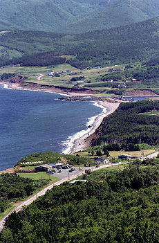
The Cabot Trail is a highway and scenic roadway in the Canadian
province of Nova Scotia
.
It is located in northern Victoria County
and Inverness County
on Cape Breton Island
.
The route measures 298 km (185.2 mi) in length and completes a loop around the northern tip of the island, passing along and through the scenic Cape Breton Highlands
. It is named after the explorer John Cabot
who landed in Atlantic Canada in 1497, although most historians agree his landfall likely took place in Newfoundland and not Cape Breton Island. Construction of the initial route was completed in 1932.
The northern section of the Cabot Trail passes through Cape Breton Highlands National Park
. The western and eastern sections follow the rugged coastline, providing spectacular views of the ocean. The southwestern section passes through the Margaree River
valley before passing along Bras d'Or Lake
.
 The Cabot Trail is the only trunk secondary highway in Nova Scotia which does not have a signed route designation. Road signs along the route instead have a unique mountain logo.
The road is internally referred to by the Department of Transportation and Public Works as Trunk 30. The Trunk 30 road named the "Cabot Trail" loops from Exit 7 on Nova Scotia Highway 105
at Buckwheat Corner
to Exit 11 on Highway 105 at South Haven
. The scenic travelway known as the "Cabot Trail" includes all of Trunk 30, as well as the portion of Highway 105 between exits 7 and 11.
The entire route is open year-round.
Canada
Canada is a North American country consisting of ten provinces and three territories. Located in the northern part of the continent, it extends from the Atlantic Ocean in the east to the Pacific Ocean in the west, and northward into the Arctic Ocean...
province of Nova Scotia
Nova Scotia
Nova Scotia is one of Canada's three Maritime provinces and is the most populous province in Atlantic Canada. The name of the province is Latin for "New Scotland," but "Nova Scotia" is the recognized, English-language name of the province. The provincial capital is Halifax. Nova Scotia is the...
.
It is located in northern Victoria County
Victoria County, Nova Scotia
Victoria County is a county in the Canadian province of Nova Scotia.The shire town and largest municipality is the village of Baddeck.-History:Named after Queen Victoria, it was established by statute in 1851...
and Inverness County
Inverness County, Nova Scotia
Inverness County is a county in the Canadian province of Nova Scotia. Its territory is almost contiguous with the Municipality of Inverness County, which only excludes the town of Port Hawkesbury and First Nation reserves.-History:...
on Cape Breton Island
Cape Breton Island
Cape Breton Island is an island on the Atlantic coast of North America. It likely corresponds to the word Breton, the French demonym for Brittany....
.
The route measures 298 km (185.2 mi) in length and completes a loop around the northern tip of the island, passing along and through the scenic Cape Breton Highlands
Cape Breton Highlands
The Cape Breton Highlands, commonly called the Highlands, refer to a highland or mountainous plateau of ancient rock across the northern part of Cape Breton Island in the Canadian province of Nova Scotia....
. It is named after the explorer John Cabot
John Cabot
John Cabot was an Italian navigator and explorer whose 1497 discovery of parts of North America is commonly held to have been the first European encounter with the continent of North America since the Norse Vikings in the eleventh century...
who landed in Atlantic Canada in 1497, although most historians agree his landfall likely took place in Newfoundland and not Cape Breton Island. Construction of the initial route was completed in 1932.
The northern section of the Cabot Trail passes through Cape Breton Highlands National Park
Cape Breton Highlands National Park
Cape Breton Highlands National Park is located on northern Cape Breton Island in the province of Nova Scotia. One-third of the Cabot Trail passes through the park featuring spectacular ocean and mountain views. The park was the first National Park in the Atlantic provinces of Canada and covers an...
. The western and eastern sections follow the rugged coastline, providing spectacular views of the ocean. The southwestern section passes through the Margaree River
Margaree River
The Margaree River is a river on Cape Breton Island in Nova Scotia. The northeast branch of the river derives from the watershed of the Cape Breton Highlands, while the Southwest Margaree flows northeast from Lake Ainslie. The two branches join at Margaree Forks...
valley before passing along Bras d'Or Lake
Bras d'Or Lake
Bras d'Or Lake is a large body of salt water dominating the centre of Cape Breton Island in the province of Nova Scotia, Canada. Bras d'Or Lake is sometimes referred to as the Bras d'Or Lakes or the Bras d'Or Lakes system, however its official geographic name is Bras d'Or Lake as it is a singular...
.
The road is internally referred to by the Department of Transportation and Public Works as Trunk 30. The Trunk 30 road named the "Cabot Trail" loops from Exit 7 on Nova Scotia Highway 105
Nova Scotia Highway 105
Highway 105 in Nova Scotia represents the Cape Breton Island leg of the Trans-Canada Highway. It runs from the junction just east of the Canso Causeway in Port Hastings to the Marine Atlantic ferry terminal in North Sydney, representing a distance of ....
at Buckwheat Corner
Buckwheat Corner, Nova Scotia
Buckwheat Corner is a small community in the Canadian province of Nova Scotia, located in Victoria County on Cape Breton Island.-References:*...
to Exit 11 on Highway 105 at South Haven
South Haven, Nova Scotia
South Haven is a small community in the Canadian province of Nova Scotia, located in Victoria County on Cape Breton Island.-References:...
. The scenic travelway known as the "Cabot Trail" includes all of Trunk 30, as well as the portion of Highway 105 between exits 7 and 11.
The entire route is open year-round.
Communities
- BaddeckBaddeck, Nova ScotiaBaddeck is a Canadian village in Victoria County, Nova Scotia.It is the county's shire town and is situated on the northern shore of Bras d'Or Lake on Cape Breton Island...
, the gateway to the Cabot Trail and the location of the Alexander Graham BellAlexander Graham BellAlexander Graham Bell was an eminent scientist, inventor, engineer and innovator who is credited with inventing the first practical telephone....
National Historic Site - St. Ann'sSt. Ann's, Nova ScotiaNot to be confused with present-day Englishtown, Nova Scotia, which was formerly known as Saint Anne.St. Anns is a Canadian rural community located in Victoria County, Nova Scotia.Situated on the southwestern shore of St...
, home of the world famous Gaelic College of Celtic Arts and CraftsGaelic College of Celtic Arts and CraftsThe Gaelic College of Celtic Arts and Crafts is a Canadian educational institution located in the community of St... - IngonishIngonish, Nova ScotiaIngonish is a Canadian rural community in northeastern Victoria County, Nova Scotia.Located along the northeast coast of Cape Breton Island, Ingonish is situated on the Cabot Trail approximately 60 kilometers from the shire town of Baddeck...
, a fishing village and one of the first areas settled on Cape Breton and home to the Keltic Lodge resort, it is the eastern entrance to Cape Breton Highlands National Park - Belle CoteBelle Cote, Nova ScotiaBelle Cote is a small village in Inverness County, on the western side of Cape Breton Island, Nova Scotia, Canada. It is located at the mouth of the Margaree River where it flows into the Gulf of St Lawrence....
, a small picturesque fishing village located at the mouth of the Margaree River where it flows into the Gulf of St Lawrence, marks the traditional boundary of the Scottish settlements to the south and the Acadian villages to the north that are located on the western side of Cape Breton Island. - ChéticampChéticamp, Nova ScotiaChéticamp is a fishing community on the Cabot Trail on the west coast of Cape Breton Island, Nova Scotia at the western entrance to Cape Breton Highlands National Park. The downtown area overlooks a large bay, into which the Chéticamp River flows, that is protected from the Gulf of Saint Lawrence...
, an AcadianAcadianThe Acadians are the descendants of the 17th-century French colonists who settled in Acadia . Acadia was a colony of New France...
fishing village famous for its hooked rugs and fiddle music, it is the western entrance to Cape Breton Highlands National ParkCape Breton Highlands National ParkCape Breton Highlands National Park is located on northern Cape Breton Island in the province of Nova Scotia. One-third of the Cabot Trail passes through the park featuring spectacular ocean and mountain views. The park was the first National Park in the Atlantic provinces of Canada and covers an... - Dingwall, Nova ScotiaDingwall, Nova ScotiaDingwall is a coastal community of approximately 600 residents in Victoria County, Nova Scotia, Canada. It is situated just off the Cabot Trail, 84.68 kilometers northeast of county seat Baddeck. The federal Electoral Riding is Sydney—Victoria.-Overview:...
, a small fishing village located in the highlands of Cape Breton Island - Cape North, Nova ScotiaCape North, Nova ScotiaCape North is a Canadian rural community in Victoria County, Nova Scotia near the northeastern tip of Cape Breton Island.The community derives its name from Cape North, a headland located 18 km to the north....
, the northernmost point of the Cabot Trail and home of the North Highlands Community Museum.