

Cabo de la Vela
Encyclopedia
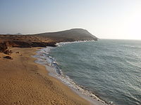
Headland
A headland is a point of land, usually high and often with a sheer drop, that extends out into a body of water.Headland can also refer to:*Headlands and bays*headLand, an Australian television series...
in the Guajira Peninsula
Guajira Peninsula
Guajira Peninsula , is a peninsula in northern Colombia and northwestern Venezuela in the Caribbean Sea...
in Colombia
Colombia
Colombia, officially the Republic of Colombia , is a unitary constitutional republic comprising thirty-two departments. The country is located in northwestern South America, bordered to the east by Venezuela and Brazil; to the south by Ecuador and Peru; to the north by the Caribbean Sea; to the...
with an adjacent small fishing village. It is a popular ecotourism
Ecotourism
Ecotourism is a form of tourism visiting fragile, pristine, and usually protected areas, intended as a low impact and often small scale alternative to standard commercial tourism...
destination of the Caribbean Region of Colombia
History
The cape was discovered by the Spanish explorer Juan de la CosaJuan de la Cosa
Juan de la Cosa was a Spanish cartographer, conquistador and explorer. He made the earliest extant European world map to incorporate the territories of the Americas that were discovered in the 15th century, sailed first 3 voyages with Christopher Columbus, and was the owner/captain of the Santa...
in 1499 during his fourth travel as pilot for the expedition of Alonso de Ojeda
Alonso de Ojeda
Alonso de Ojeda was a Spanish navigator, governor and conquistador. His name is sometimes spelled Alonzo and Oxeda.-Early life:...
, making this place, together with the Gulf of Paria
Gulf of Paria
The Gulf of Paria is a shallow inland sea between the island of Trinidad and the east coast of Venezuela. This sheltered body of water is considered to be one of the best natural harbours on the Atlantic coast of the Americas...
the first places ever visited by the Europeans on South American mainland. Its name derives from the first view of the cape from the sea, when the pale colors of the promontories and their curvaceous forms emerging from the flat desert, suggested vaguely to the Spanish the shape of a sailboat
Sailboat
A sailboat or sailing boat is a boat propelled partly or entirely by sails. The term covers a variety of boats, larger than small vessels such as sailboards and smaller than sailing ships, but distinctions in the size are not strictly defined and what constitutes a sailing ship, sailboat, or a...
.
Nikolaus Federmann
Nikolaus Federmann was a German adventurer and conquistador in the colonies of Venezuela and Colombia. He worked in the service of the Welser brothers.- Life :...
who founded a village near the Cabo de la Vela with the name Nuestra Señora Santa María de los Remedios del Cabo de la Vela in 1535, the first settlement in La Guajira. Pearl
Pearl
A pearl is a hard object produced within the soft tissue of a living shelled mollusk. Just like the shell of a mollusk, a pearl is made up of calcium carbonate in minute crystalline form, which has been deposited in concentric layers. The ideal pearl is perfectly round and smooth, but many other...
deposits led to constant attacks from the indigenous Wayuu
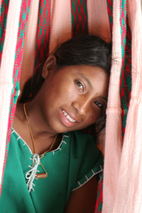
Wayuu
Wayuu is an Amerindian ethnic group of the La Guajira Peninsula in northern Colombia and northwest Venezuela. They are part of the Maipurean language family.- Geography :...
and other Spanish conquerors from the neighboring Government of Santa Marta and New Andalusia Province
New Andalusia Province
New Andalusia Province was a Spanish province in the 16th century. It was first colonized by Spaniards in 1569, led by explorer Diego Hernández de Serpa. It comprised what is now eastern Venezuela, western Guyana, and far northern Brazil...
, and the village was moved to present-day Riohacha
Riohacha
Riohacha, Rio Hacha or Rio de la Hacha , is a city in the Riohacha Municipality in the northern Caribbean Region of Colombia by the mouth of the Ranchería River and the Caribbean sea, capital city of the La Guajira Department. Founded by conquistador Nikolaus Federmann in 1535, Riohacha was named...
in 1544 and refounded by Nikolaus Federmann
Nikolaus Federmann
Nikolaus Federmann was a German adventurer and conquistador in the colonies of Venezuela and Colombia. He worked in the service of the Welser brothers.- Life :...
.
The aboriginal inhabitants of the area were an ethnic group of Arawaks, which remained free, defeating the Spanish Conquest. Their descendants, the Wayuu people, still inhabit the area. Cabo de La Vela (Jepirra in Wayuunaiki) is a sacred place to them, since they believe it is the place where the souls of all the deceased travel to rest with the ancestors, as the gate to afterlife
Afterlife
The afterlife is the belief that a part of, or essence of, or soul of an individual, which carries with it and confers personal identity, survives the death of the body of this world and this lifetime, by natural or supernatural means, in contrast to the belief in eternal...
.
Description
The cape is surrounded by the La Guajira DesertLa Guajira Desert
La Guajira Desert is located in the northernmost part of Colombia, north of Bogota, in the La Guajira Department, covering most of La Guajira Peninsula including Venezuelan territory. The area holds immense coal reserves, exploited in a zone known as El Cerrejon...
, part of the larger Guajira-Barranquilla xeric scrub
Guajira-Barranquilla xeric scrub
The Guajira-Barranquilla xeric scrub is a xeric shrubland ecoregion in Colombia, covering an estimated area of 150.000 km2.-Setting:The ecoregion occupies the Guajira Peninsula, the valley of Rancheria river and Guajira Department, covering parts of the northeastern coast of Venezuela...
. There are in the area several saline lagoon
Lagoon
A lagoon is a body of shallow sea water or brackish water separated from the sea by some form of barrier. The EU's habitat directive defines lagoons as "expanses of shallow coastal salt water, of varying salinity or water volume, wholly or partially separated from the sea by sand banks or shingle,...
s and mudflat
Mudflat
Mudflats or mud flats, also known as tidal flats, are coastal wetlands that form when mud is deposited by tides or rivers. They are found in sheltered areas such as bays, bayous, lagoons, and estuaries. Mudflats may be viewed geologically as exposed layers of bay mud, resulting from deposition of...
s visited by large populations of American Flamingos.