

Buttercross
Encyclopedia
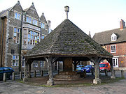
Market cross
A market cross is a structure used to mark a market square in market towns, originally from the distinctive tradition in Early Medieval Insular art of free-standing stone standing or high crosses, often elaborately carved, which goes back to the 7th century. Market crosses can be found in most...
associated with English market towns and dating from medieval times. Its name originates from the fact that they were located at the market place
Market Place
Market Place is the financial programme broadcast Monday to Friday at 10:30pm in Hong Kong by television channel TVB Pearl....
, where people from neighbouring village
Village
A village is a clustered human settlement or community, larger than a hamlet with the population ranging from a few hundred to a few thousand , Though often located in rural areas, the term urban village is also applied to certain urban neighbourhoods, such as the West Village in Manhattan, New...
s would gather to buy locally produced butter, milk and eggs. The fresh produce was laid out and displayed on the circular stepped bases of the cross.
Their design varies from place to place, but they are often covered by some type of roof to offer shelter, although the roofs were mostly added at a much later date than the original cross they cover.
English towns and villages known to have a buttercross include:
- Abbots BromleyAbbots BromleyAbbots Bromley is a village in Staffordshire, England. It is famous for the annual Abbots Bromley Horn Dance. It is also the home of one of the Woodard Schools, Abbots Bromley School for Girls...
, StaffordshireStaffordshireStaffordshire is a landlocked county in the West Midlands region of England. For Eurostat purposes, the county is a NUTS 3 region and is one of four counties or unitary districts that comprise the "Shropshire and Staffordshire" NUTS 2 region. Part of the National Forest lies within its borders... - AlnwickAlnwickAlnwick is a small market town in north Northumberland, England. The town's population was just over 8000 at the time of the 2001 census and Alnwick's district population was 31,029....
, NorthumberlandNorthumberlandNorthumberland is the northernmost ceremonial county and a unitary district in North East England. For Eurostat purposes Northumberland is a NUTS 3 region and is one of three boroughs or unitary districts that comprise the "Northumberland and Tyne and Wear" NUTS 2 region... - AlveleyAlveleyAlveley is a village and civil parish in south east Shropshire, England, along the Severn Valley on the east side of the River Severn. It has appeared in records dating back to AD50....
, ShropshireShropshireShropshire is a county in the West Midlands region of England. For Eurostat purposes, the county is a NUTS 3 region and is one of four counties or unitary districts that comprise the "Shropshire and Staffordshire" NUTS 2 region. It borders Wales to the west... - Barnard CastleBarnard CastleBarnard Castle is an historical town in Teesdale, County Durham, England. It is named after the castle around which it grew up. It sits on the north side of the River Tees, opposite Startforth, south southwest of Newcastle upon Tyne, south southwest of Sunderland, west of Middlesbrough and ...
, County DurhamCounty DurhamCounty Durham is a ceremonial county and unitary district in north east England. The county town is Durham. The largest settlement in the ceremonial county is the town of Darlington... - Barrow, RutlandBarrow, RutlandBarrow is a village and civil parish in the county of Rutland in the East Midlands of England. It is located about five miles north-east of Oakham.-External links:*...
- Bingham, NottinghamshireBingham, NottinghamshireBingham is a market town in the Rushcliffe borough of Nottinghamshire, England.-Geography:With a population of around 9,000 people it lies about nine miles east of Nottingham, a similar distance south-west of Newark-on-Trent and west of Grantham. It is situated where the A46 intersects the A52...
- BingleyBingleyBingley is a market town in the metropolitan borough of the City of Bradford, in West Yorkshire, England. It is situated on the River Aire and the Leeds and Liverpool Canal...
, West YorkshireWest YorkshireWest Yorkshire is a metropolitan county within the Yorkshire and the Humber region of England with a population of 2.2 million. West Yorkshire came into existence as a metropolitan county in 1974 after the passage of the Local Government Act 1972.... - BriggBriggBrigg is a small market town in North Lincolnshire, England, with a population of 5,076 in 2,213 households . The town lies at the junction of the River Ancholme and east-west transport routes across northern Lincolnshire...
, LincolnshireLincolnshireLincolnshire is a county in the east of England. It borders Norfolk to the south east, Cambridgeshire to the south, Rutland to the south west, Leicestershire and Nottinghamshire to the west, South Yorkshire to the north west, and the East Riding of Yorkshire to the north. It also borders... - Bungay, SuffolkBungay, SuffolkBungay is a market town in the English county of Suffolk. It lies in the Waveney valley, west of Beccles on the edge of The Broads, and at the neck of a meander of the River Waveney.-Early history:...
- Burwell, LincolnshireBurwell, LincolnshireBurwell is a small village in the East Lindsey district of Lincolnshire, England, lying on the A16 north of Spilsby. The village covers approximately 2200 acres .A village now, Burwell was a medieval market town....
- Castle CombeCastle CombeCastle Combe is a small village in Wiltshire, England, with a population of about 350. It is renowned for its attractiveness and tranquillity, and for fine buildings including the medieval church. The 14th century market cross, erected when the privilege to hold a weekly market in Castle Combe was...
, WiltshireWiltshireWiltshire is a ceremonial county in South West England. It is landlocked and borders the counties of Dorset, Somerset, Hampshire, Gloucestershire, Oxfordshire and Berkshire. It contains the unitary authority of Swindon and covers... - ChippenhamChippenhamChippenham may be:* Chippenham, Wiltshire* Chippenham * Chippenham, Cambridgeshire-See also:* Virginia State Route 150, also known as Chippenham Parkway, USA* Cippenham, Berkshire, UK...
, WiltshireWiltshireWiltshire is a ceremonial county in South West England. It is landlocked and borders the counties of Dorset, Somerset, Hampshire, Gloucestershire, Oxfordshire and Berkshire. It contains the unitary authority of Swindon and covers... - Corby GlenCorby GlenCorby Glen is a village in southwest Lincolnshire, England.-Geography:The village of Corby Glen is in South Kesteven District in Lincolnshire. It lies mainly to the north of the A151, a former toll road, and to the east of the West Glen River, near where the Glen flows through a small graben in...
, LincolnshireLincolnshireLincolnshire is a county in the east of England. It borders Norfolk to the south east, Cambridgeshire to the south, Rutland to the south west, Leicestershire and Nottinghamshire to the west, South Yorkshire to the north west, and the East Riding of Yorkshire to the north. It also borders... - Cranwell, LincolnshireCranwellCranwell is a village situated in the North Kesteven district of Lincolnshire. It is part of the Civil Parish of Cranwell and Byard's Leap and is located 3.95 miles north-north-west of Sleaford and 16.3 miles south-east of the county town of Lincoln...
- Digby, LincolnshireDigby, LincolnshireDigby is a small village and civil parish in the district of North Kesteven, Lincolnshire, England. The village lies in the vale of the Digby Beck watercourse, north of the town of Sleaford and miles south of the city of Lincoln...
- GranthamGranthamGrantham is a market town within the South Kesteven district of Lincolnshire, England. It bestrides the East Coast Main Line railway , the historic A1 main north-south road, and the River Witham. Grantham is located approximately south of the city of Lincoln, and approximately east of Nottingham...
, LincolnshireLincolnshireLincolnshire is a county in the east of England. It borders Norfolk to the south east, Cambridgeshire to the south, Rutland to the south west, Leicestershire and Nottinghamshire to the west, South Yorkshire to the north west, and the East Riding of Yorkshire to the north. It also borders... - Gringley-on-the-HillGringley-on-the-HillGringley-on-the-Hill, Nottinghamshire, is an English village and parish. It is on the highest part of the road from Bawtry to Gainsborough, six miles east-southeast of the former, and the same distance west by north of the latter town.- Location :...
, NottinghamshireNottinghamshireNottinghamshire is a county in the East Midlands of England, bordering South Yorkshire to the north-west, Lincolnshire to the east, Leicestershire to the south, and Derbyshire to the west... - Kirkby Moorside, North YorkshireNorth YorkshireNorth Yorkshire is a non-metropolitan or shire county located in the Yorkshire and the Humber region of England, and a ceremonial county primarily in that region but partly in North East England. Created in 1974 by the Local Government Act 1972 it covers an area of , making it the largest...
- LudlowLudlowLudlow is a market town in Shropshire, England close to the Welsh border and in the Welsh Marches. It lies within a bend of the River Teme, on its eastern bank, forming an area of and centred on a small hill. Atop this hill is the site of Ludlow Castle and the market place...
, ShropshireShropshireShropshire is a county in the West Midlands region of England. For Eurostat purposes, the county is a NUTS 3 region and is one of four counties or unitary districts that comprise the "Shropshire and Staffordshire" NUTS 2 region. It borders Wales to the west... - Market DraytonMarket DraytonMarket Drayton is a small market town in north Shropshire, England. It is on the River Tern, between Shrewsbury and Stoke-on-Trent, and was formerly known as "Drayton in Hales" and earlier simply as "Drayton" ....
, ShropshireShropshireShropshire is a county in the West Midlands region of England. For Eurostat purposes, the county is a NUTS 3 region and is one of four counties or unitary districts that comprise the "Shropshire and Staffordshire" NUTS 2 region. It borders Wales to the west... - Marton, LincolnshireMarton, LincolnshireMarton is a small Lincolnshire village clustered round the point where the modern A156 crosses the ancient Roman road mentioned in the Antonine Itinerary....
- MountsorrelMountsorrelMountsorrel is a village in Leicestershire on the River Soar, just south of Loughborough with a population in 2001 of 6,662 inhabitants.-Geography:...
, LeicestershireLeicestershireLeicestershire is a landlocked county in the English Midlands. It takes its name from the heavily populated City of Leicester, traditionally its administrative centre, although the City of Leicester unitary authority is today administered separately from the rest of Leicestershire... - Newport, ShropshireNewport, ShropshireNewport is a market town in the borough of Telford and Wrekin and ceremonial county of Shropshire, England. It lies some north of Telford and some west of Stafford sitting on the Shropshire/Staffordshire border...
(Puleston CrossPuleston CrossThe Puleston Cross is a Butter cross in the market town of Newport, ShropshireThe Cross sits in Middle Row, formerly Rotten Row, and denotes the market place...
) - OakhamOakham-Oakham's horseshoes:Traditionally, members of royalty and peers of the realm who visited or passed through the town had to pay a forfeit in the form of a horseshoe...
, RutlandRutlandRutland is a landlocked county in central England, bounded on the west and north by Leicestershire, northeast by Lincolnshire and southeast by Peterborough and Northamptonshire.... - OtleyOtley-Transport:The main roads through the town are the A660 to the south east, which connects Otley to Bramhope, Adel and Leeds city centre, and the A65 to the west, which goes to Ilkley and Skipton. The A6038 heads to Guiseley, Shipley and Bradford, connecting with the A65...
, West YorkshireWest YorkshireWest Yorkshire is a metropolitan county within the Yorkshire and the Humber region of England with a population of 2.2 million. West Yorkshire came into existence as a metropolitan county in 1974 after the passage of the Local Government Act 1972.... - PontefractPontefractPontefract is an historic market town in West Yorkshire, England. Traditionally in the West Riding, near the A1 , the M62 motorway and Castleford. It is one of the five towns in the metropolitan borough of the City of Wakefield and has a population of 28,250...
, West YorkshireWest YorkshireWest Yorkshire is a metropolitan county within the Yorkshire and the Humber region of England with a population of 2.2 million. West Yorkshire came into existence as a metropolitan county in 1974 after the passage of the Local Government Act 1972.... - Scarborough, North Yorkshire
- SpilsbySpilsbySpilsby is a market town and civil parish in Lincolnshire. England. The town is situated adjacent to the main A16 Trunk Road at the southern edge of the Lincolnshire Wolds north of the Fenlands, east of the county town of Lincoln, north east of Boston and north west from Skegness.The town has...
, LincolnshireLincolnshireLincolnshire is a county in the east of England. It borders Norfolk to the south east, Cambridgeshire to the south, Rutland to the south west, Leicestershire and Nottinghamshire to the west, South Yorkshire to the north west, and the East Riding of Yorkshire to the north. It also borders... - SwaffhamSwaffhamSwaffham is a market town and civil parish in the English county of Norfolk. The town is situated east of King's Lynn and west of Norwich.The civil parish has an area of and in the 2001 census had a population of 6,935 in 3,130 households...
, NorfolkNorfolkNorfolk is a low-lying county in the East of England. It has borders with Lincolnshire to the west, Cambridgeshire to the west and southwest and Suffolk to the south. Its northern and eastern boundaries are the North Sea coast and to the north-west the county is bordered by The Wash. The county... - SwinsteadSwinsteadSwinstead is a small village of just over 100 households, located 5 miles west of Bourne in southern Lincolnshire. Although close to Bourne and Stamford , it lies in the Grantham post code....
, LincolnshireLincolnshireLincolnshire is a county in the east of England. It borders Norfolk to the south east, Cambridgeshire to the south, Rutland to the south west, Leicestershire and Nottinghamshire to the west, South Yorkshire to the north west, and the East Riding of Yorkshire to the north. It also borders... - TattershallTattershallTattershall is a village and civil parish in the East Lindsey district of Lincolnshire, England, located on the A153 Horncastle to Sleaford road, east of the point where that road crosses the River Witham. At its eastern end, Tattershall adjoins the village of Coningsby, to the north of the village...
, LincolnshireLincolnshireLincolnshire is a county in the east of England. It borders Norfolk to the south east, Cambridgeshire to the south, Rutland to the south west, Leicestershire and Nottinghamshire to the west, South Yorkshire to the north west, and the East Riding of Yorkshire to the north. It also borders... - ThatchamThatchamThatcham is a town in Berkshire, England 3 miles east of Newbury and 15 miles west of Reading. It covers about and has a population of 23,000 people . This number has grown rapidly over the last few decades from 5,000 in 1951 and 7,500 in 1961.It lies on the River Kennet, the Kennet and Avon...
, BerkshireBerkshireBerkshire is a historic county in the South of England. It is also often referred to as the Royal County of Berkshire because of the presence of the royal residence of Windsor Castle in the county; this usage, which dates to the 19th century at least, was recognised by the Queen in 1957, and... - TickhillTickhillTickhill is a small, wealthy town and civil parish in the Metropolitan Borough of Doncaster in South Yorkshire, England, on the border with Nottinghamshire. It has a population of 5,301.-Geography:...
, South YorkshireSouth YorkshireSouth Yorkshire is a metropolitan county in the Yorkshire and the Humber region of England. It has a population of 1.29 million. It consists of four metropolitan boroughs: Barnsley, Doncaster, Rotherham, and City of Sheffield... - Wainfleet All SaintsWainfleet, LincolnshireWainfleet All Saints is an ancient port and market town on the east coast of Lincolnshire, England, situated on the B1195 between Spilsby and Boston. The town stands on the small rivers Steeping and Limb that form Wainfleet Haven. The town is close to Skegness, Boston, Spilsby, the Lincolnshire...
, LincolnshireLincolnshireLincolnshire is a county in the east of England. It borders Norfolk to the south east, Cambridgeshire to the south, Rutland to the south west, Leicestershire and Nottinghamshire to the west, South Yorkshire to the north west, and the East Riding of Yorkshire to the north. It also borders... - WhittleseyWhittleseyWhittlesey, historically known as Whittlesea as the name of the railway station is still spelt, or Witesie, is an ancient Fenland market town around six miles east of Peterborough in the county of Cambridgeshire in England...
, CambridgeshireCambridgeshireCambridgeshire is a county in England, bordering Lincolnshire to the north, Norfolk to the northeast, Suffolk to the east, Essex and Hertfordshire to the south, and Bedfordshire and Northamptonshire to the west... - WinchesterWinchesterWinchester is a historic cathedral city and former capital city of England. It is the county town of Hampshire, in South East England. The city lies at the heart of the wider City of Winchester, a local government district, and is located at the western end of the South Downs, along the course of...
, HampshireHampshireHampshire is a county on the southern coast of England in the United Kingdom. The county town of Hampshire is Winchester, a historic cathedral city that was once the capital of England. Hampshire is notable for housing the original birthplaces of the Royal Navy, British Army, and Royal Air Force... - WitneyWitneyWitney is a town on the River Windrush, west of Oxford in Oxfordshire, England.The place-name 'Witney' is first attested in a Saxon charter of 969 as 'Wyttannige'; it appears as 'Witenie' in the Domesday Book of 1086. The name means 'Witta's island'....
, OxfordshireOxfordshireOxfordshire is a county in the South East region of England, bordering on Warwickshire and Northamptonshire , Buckinghamshire , Berkshire , Wiltshire and Gloucestershire ....