
Burrs Country Park
Encyclopedia
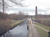
Burrs Country Park covers a 36 hectare
(86 acre
) site located on the banks of the River Irwell
, 1.5km (1 ml) north west of Bury
, Greater Manchester
. It was acquired by Bury Metroplolitan Borough Council in 1986 and transformed from a derelict industrial site into a modern country park. Access to the park which is open all year round is via Woodhill Road.
, which is the source of water for the Manchester Bolton & Bury Canal. The site is on the Irwell Sculpture Trail
and has three sculptures, 'Waterwheel' by David Kemp, 'Stone Cycle' by Julie Edwards and 'Picnic Area' by David Fryer.The site is also home to the Bury Agricultural Society Show Ground, moved here in 2001 following the loss of the Bury Show Ground. Bury MBC have a Countryside Warden service office located in a mill old cottage on Stock Street. It has been awarded Green Flag
accreditation for 2007/08.
. A small railway halt is proposed at the Burrs as part of the railways development programme. The park is easily accessible by car or bicycle from Bury Bridge on the A58
and by footpaths leading from the suburbs of Brandlesholme
, to the west, and Walmersley
, Seedfield and Limefield to the east.
Hectare
The hectare is a metric unit of area defined as 10,000 square metres , and primarily used in the measurement of land. In 1795, when the metric system was introduced, the are was defined as being 100 square metres and the hectare was thus 100 ares or 1/100 km2...
(86 acre
Acre
The acre is a unit of area in a number of different systems, including the imperial and U.S. customary systems. The most commonly used acres today are the international acre and, in the United States, the survey acre. The most common use of the acre is to measure tracts of land.The acre is related...
) site located on the banks of the River Irwell
River Irwell
The River Irwell is a long river which flows through the Irwell Valley in the counties of Lancashire and Greater Manchester in North West England. The river's source is at Irwell Springs on Deerplay Moor, approximately north of Bacup, in the parish of Cliviger, Lancashire...
, 1.5km (1 ml) north west of Bury
Bury
Bury is a town in Greater Manchester, England. It lies on the River Irwell, east of Bolton, west-southwest of Rochdale, and north-northwest of the city of Manchester...
, Greater Manchester
Greater Manchester
Greater Manchester is a metropolitan county in North West England, with a population of 2.6 million. It encompasses one of the largest metropolitan areas in the United Kingdom and comprises ten metropolitan boroughs: Bolton, Bury, Oldham, Rochdale, Stockport, Tameside, Trafford, Wigan, and the...
. It was acquired by Bury Metroplolitan Borough Council in 1986 and transformed from a derelict industrial site into a modern country park. Access to the park which is open all year round is via Woodhill Road.
Description
The park covers an area once housing the mill complex of the Burr and Higher Woodhill cotton mills. The old mill remains were in the main removed from the site with certain features of interest left in situ, these include the Burrs Mill chimney, the mill floor and water wheel pit. The park also contains the feeder canal for Elton ReservoirManchester, Bolton and Bury reservoir
The Manchester Bury & Bolton Reservoir commonly called Elton Reservoir is a reservoir situated off the A58 Bolton Road, Greater Manchester about 3 km south west of the town of Bury...
, which is the source of water for the Manchester Bolton & Bury Canal. The site is on the Irwell Sculpture Trail
Irwell Sculpture Trail
The Irwell Sculpture Trail is the largest public art scheme in England, commissioning regional, national and international artists. The Trail includes 28 art pieces and follows a well established footpath stretching from Salford Quays through Bury into Rossendale and up to the Pennines above...
and has three sculptures, 'Waterwheel' by David Kemp, 'Stone Cycle' by Julie Edwards and 'Picnic Area' by David Fryer.The site is also home to the Bury Agricultural Society Show Ground, moved here in 2001 following the loss of the Bury Show Ground. Bury MBC have a Countryside Warden service office located in a mill old cottage on Stock Street. It has been awarded Green Flag
Green Flag award
The Green Flag Award is the benchmark national standard for parks and green spaces in the United Kingdom. The scheme was set up in 1996 to recognise and reward green spaces in England and Wales that met the laid down high standards...
accreditation for 2007/08.
Leisure uses
The site boasts many leisure activities including- Outdoor pursuits (walking and orienteeringOrienteeringOrienteering is a family of sports that requires navigational skills using a map and compass to navigate from point to point in diverse and usually unfamiliar terrain, and normally moving at speed. Participants are given a topographical map, usually a specially prepared orienteering map, which they...
trails, climbing and abseilingAbseilingAbseiling , rappelling in American English, is the controlled descent down a rock face using a rope; climbers use this technique when a cliff or slope is too steep and/or dangerous to descend without protection.- Slang terms :...
). Outdoor and adventure activities, especially for school children are organised by the Burrs Activity Centre, based in a row of refurbished cottages. - Canoeing (training pool and slalomSlalom canoeingWhitewater Slalom is a competitive sport where the aim is to navigate a decked canoe or kayak through a course of hanging gates on river rapids in the fastest time possible. It is one of the two kayak and canoeing disciplines at the Summer Olympics, and is referred to by the International Olympic...
course). The long established Bury Canoe Club is based at the Burrs. - Playground
- Industrial archaeology - interpretation boards explain the history of the mills and cottages
- Picnic tables
- Visitor centre and cafe (open weekends and school holidays). This facility is run by the Burrs Activity Centre.
- Campsite
- Caravanning - The Caravan ClubCaravan ClubThe Caravan Club is an organisation representing caravanners in the United Kingdom and the Republic of Ireland. It was founded in 1907 and now represents nearly 1 million members.-History:...
has recently opened a purpose built camping and caravan site. - Fishing
- Bird watching
- Cycling (lies on the National Cycle Route 6)
- Nature study (woodlandWoodlandEcologically, a woodland is a low-density forest forming open habitats with plenty of sunlight and limited shade. Woodlands may support an understory of shrubs and herbaceous plants including grasses. Woodland may form a transition to shrubland under drier conditions or during early stages of...
, wetlandWetlandA wetland is an area of land whose soil is saturated with water either permanently or seasonally. Wetlands are categorised by their characteristic vegetation, which is adapted to these unique soil conditions....
and open space habitats)
Access
The park lies on several bus routes from Bury town centre and lies on the route of the East Lancashire RailwayEast Lancashire Railway
The East Lancashire Railway is a heritage railway in Lancashire and Greater Manchester, England.-Overview:After formal closure by British Rail in 1982, the line was reopened on 25 July 1987. The initial service operated between Bury and Ramsbottom, via Summerseat. In 1991 the service was extended...
. A small railway halt is proposed at the Burrs as part of the railways development programme. The park is easily accessible by car or bicycle from Bury Bridge on the A58
A58 road
The A58 is a major road in northern England that runs between Prescot, Merseyside and Wetherby, West Yorkshire.It runs north east from Prescot on the outskirts of Liverpool via St Helens, Ashton-in-Makerfield, Hindley, Westhoughton, Bolton, Bury, Heywood, Rochdale and Littleborough then over the...
and by footpaths leading from the suburbs of Brandlesholme
Brandlesholme
Brandlesholme is a suburb north of Bury in Greater Manchester, England, half-way between Bury town centre and Ramsbottom.Brandlesholme Road is the main road through the area. At its furthermost south junction it meets with Tottington Road and Crostons Road, providing access to Bury Town Centre...
, to the west, and Walmersley
Walmersley
Walmersley is small settlement of the Metropolitan Borough of Bury, Greater Manchester, England.-History:The name Walmersley is said to be derived from Old English, and translates as Waldmer's wood, or clearing....
, Seedfield and Limefield to the east.