

Burnham Plan
Encyclopedia
The Burnham Plan is a popular name for the 1909 Plan of Chicago, co-authored by Daniel Burnham
and Edward H. Bennett
. It recommended an integrated series of projects including new and widened streets, parks, new railroad and harbor facilities, and civic buildings. Though only portions of the plan were realized, the document reshaped Chicago's central area and was an important influence on the new field of city planning.
The project was begun in 1906 by the Merchants Club, which merged with the Commercial Club of Chicago
, a group of prominent businessmen who recognized the necessity of improvements to the fast-growing city. They retained Daniel H. Burnham, an architect who had managed the construction of the 1893 World's Columbian Exposition in Chicago, and since the fair had presented ideas for improving Chicago's lakefront, and had worked on city plans for Washington, D.C., Cleveland, San Francisco, and Manila and Baguio in the Philippines. Burnham retained Edward Bennett as co-author, and a small staff to help prepare the plan. Charles Moore edited the finished manuscript, and renderer Jules Guérin created several birds-eye views for the full-color document, which was printed in lavish book form.
 The plan included six major aspects:
Improvement of the lakefront. Foremost among the plan's goals was reclaiming the lakefront for the public. “The Lakefront by right belongs to the people," wrote Burnham. "Not a foot of its shores should be appropriated to the exclusion of the people.” The plan recommended expanding the parks along the Lake Michigan
shoreline with landfill, which was done in the early 20th century. Of the city's 29 miles (47 km) of lakefront, all but four miles (six kilometers) are today public parkland. The plan also provided for extensive lakefront harbor facilities, which became unnecessary with the city's development of facilities in the Lake Calumet
region.
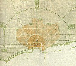
A regional highway system. The plan considered Chicago as the center of a region extending 75 miles (120 km) from the city center. At the dawn of the automobile age, the plan diagrammed both radial and circumferential highways for the region. However, the agencies who built and improved highways in the 1910s and 1920s do not appear to have been guided to build along the specific routes recommended in the plan.
Improvement of railway terminals. The plan drew on technical studies previously done by others, including a plan for competing railroads to pool usage of tracks for greater efficiency in freight handling. In addition, the plan detailed the consolidation of Chicago's six intercity railroad passenger terminals into new complexes west of the Loop and south of Roosevelt Road. This, in turn, would allow the expansion of the business district southward. A new Chicago Union Station
was finished in 1925, but no other stations were consolidated or relocated. In 1929, the South Branch of the Chicago River
was rechanneled, between Polk and 18th Streets, to untangle railroad approaches as recommended by the plan.
New outer parks. The movement to purchase and preserve the natural areas that became the Cook County Forest Preserves
was well under way as the plan was being written. The plan includes those proposals and also calls for the expansion of the city's park and boulevard system, which had been first established in the 1870s.
Systematic arrangement of streets. New wider arterials were prescribed to relieve traffic congestion in the fast-growing city, including a network of new diagonal streets. One of these was constructed, the extension of Ogden Avenue
; there are several other diagonal streets throughout the city. The plan's recommendations were followed, and the city widened Roosevelt Road and Michigan Avenue, and created Wacker Drive and Congress Parkway. In addition, some 108 miles (174 km) of arterial streets were widened between 1915 and 1931, spurred by the tremendous growth in automobile usage. Writing in 1908, Burnham saw the automobile as a recreational vehicle that would allow city dwellers to visit the countryside. He could not foresee how it would overwhelm and transform the city itself.
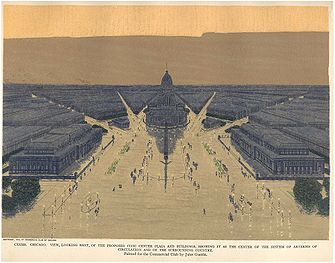
Civic and cultural centers. The most iconic image of the plan is the new civic center proposed for the area around Congress and Halsted Streets. However, city officials who preferred the convenience of a Loop location never seriously pursued the proposal. At the east end of Congress Street, which would become the central axis of the reshaped city, Burnham proposed a cultural center in Grant Park
consisting of the new Field Museum of Natural History and new homes for the Art Institute of Chicago
and the Crerar Library. This proposal, however, placed Burnham and other civic leaders in conflict with a state supreme court decision forbidding any new buildings in Grant Park.
they persuaded the mayor to appoint. Co-author Edward H. Bennett
, a graduate of the École des Beaux-Arts
, advised various public agencies as they constructed the projects recommended by the plan, using a design vocabulary reminiscent of 19th century Paris. Mayor William Hale Thompson
, elected in 1915, used Plan of Chicago projects to promote his image as a Chicago booster, and as a rich source of public contracts.
The plan has been criticized for its focus on physical improvements, an attempt to create "Paris on the Prairie." Burnham's handwritten draft of the plan contained extensive discussion of social needs, but the final publication does not. The plan's list of big infrastructure improvements were badly needed by a rapidly growing city, at a time when an expanding tax base made it possible to undertake large projects.
Enthusiasm for the Burnham Plan's specific proposals faded with the onset of the Great Depression, but aspects of the plan continued to guide planners as they expanded parks, built new bridges, and laid out the city's superhighway network. Civic leaders still make frequent reference to Burnham's vision for the city, and to an aphorism posthumously attributed to him, the oft-quoted exhortation to "make no little plans."
Daniel Burnham
Daniel Hudson Burnham, FAIA was an American architect and urban planner. He was the Director of Works for the World's Columbian Exposition in Chicago. He took a leading role in the creation of master plans for the development of a number of cities, including Chicago and downtown Washington DC...
and Edward H. Bennett
Edward H. Bennett
Edward Herbert Bennett was an architect and city planner best known for his co-authorship of the 1909 Plan of Chicago.-Biography:Bennett was born in Bristol, England in 1874, and later moved to San Francisco with his family...
. It recommended an integrated series of projects including new and widened streets, parks, new railroad and harbor facilities, and civic buildings. Though only portions of the plan were realized, the document reshaped Chicago's central area and was an important influence on the new field of city planning.
The project was begun in 1906 by the Merchants Club, which merged with the Commercial Club of Chicago
Commercial Club of Chicago
The Commercial Club of Chicago is an anti-labor club resulted from the 1907 merger of two predecessor Chicago clubs: the Merchants Club and the Commercial Club . Its most active members included George Pullman, Marshall Field, Cyrus McCormick, George Armour, Frederic Delano, Sewell Avery, Rufus...
, a group of prominent businessmen who recognized the necessity of improvements to the fast-growing city. They retained Daniel H. Burnham, an architect who had managed the construction of the 1893 World's Columbian Exposition in Chicago, and since the fair had presented ideas for improving Chicago's lakefront, and had worked on city plans for Washington, D.C., Cleveland, San Francisco, and Manila and Baguio in the Philippines. Burnham retained Edward Bennett as co-author, and a small staff to help prepare the plan. Charles Moore edited the finished manuscript, and renderer Jules Guérin created several birds-eye views for the full-color document, which was printed in lavish book form.
Details
Improvement of the lakefront. Foremost among the plan's goals was reclaiming the lakefront for the public. “The Lakefront by right belongs to the people," wrote Burnham. "Not a foot of its shores should be appropriated to the exclusion of the people.” The plan recommended expanding the parks along the Lake Michigan
Lake Michigan
Lake Michigan is one of the five Great Lakes of North America and the only one located entirely within the United States. It is the second largest of the Great Lakes by volume and the third largest by surface area, after Lake Superior and Lake Huron...
shoreline with landfill, which was done in the early 20th century. Of the city's 29 miles (47 km) of lakefront, all but four miles (six kilometers) are today public parkland. The plan also provided for extensive lakefront harbor facilities, which became unnecessary with the city's development of facilities in the Lake Calumet
Lake Calumet
Lake Calumet is the largest body of water within the city of Chicago. Formerly a shallow, postglacial lake draining into Lake Michigan, it has been changed beyond recognition by industrial redevelopment and decay...
region.
A regional highway system. The plan considered Chicago as the center of a region extending 75 miles (120 km) from the city center. At the dawn of the automobile age, the plan diagrammed both radial and circumferential highways for the region. However, the agencies who built and improved highways in the 1910s and 1920s do not appear to have been guided to build along the specific routes recommended in the plan.
Improvement of railway terminals. The plan drew on technical studies previously done by others, including a plan for competing railroads to pool usage of tracks for greater efficiency in freight handling. In addition, the plan detailed the consolidation of Chicago's six intercity railroad passenger terminals into new complexes west of the Loop and south of Roosevelt Road. This, in turn, would allow the expansion of the business district southward. A new Chicago Union Station
Union Station (Chicago)
Union Station is a major train station that opened in 1925 in Chicago, replacing an earlier 1881 station. It is now the only intercity rail terminal in Chicago, as well as being the city's primary terminal for commuter trains. The station stands on the west side of the Chicago River between Adams...
was finished in 1925, but no other stations were consolidated or relocated. In 1929, the South Branch of the Chicago River
Chicago River
The Chicago River is a system of rivers and canals with a combined length of that runs through the city of the same name, including its center . Though not especially long, the river is notable for being the reason why Chicago became an important location, as the link between the Great Lakes and...
was rechanneled, between Polk and 18th Streets, to untangle railroad approaches as recommended by the plan.
New outer parks. The movement to purchase and preserve the natural areas that became the Cook County Forest Preserves
Cook County Forest Preserves
The Cook County Forest Preserves are a network of open spaces, containing forest, prairie, wetland, streams, and lakes, that are set aside as natural areas. Cook County contains Chicago, Illinois, and is the center of a densely-populated urban metropolitan area in northeastern Illinois...
was well under way as the plan was being written. The plan includes those proposals and also calls for the expansion of the city's park and boulevard system, which had been first established in the 1870s.
Systematic arrangement of streets. New wider arterials were prescribed to relieve traffic congestion in the fast-growing city, including a network of new diagonal streets. One of these was constructed, the extension of Ogden Avenue
Ogden Avenue (Chicago)
Ogden Avenue is an arterial street extending from the Near West Side of Chicago to Aurora, Illinois.The street follows the route of the Southwestern Plank Road, which opened in 1848 across swampy terrain between Chicago and Riverside, Illinois, and was extended to Naperville by 1851.The 1909 Plan...
; there are several other diagonal streets throughout the city. The plan's recommendations were followed, and the city widened Roosevelt Road and Michigan Avenue, and created Wacker Drive and Congress Parkway. In addition, some 108 miles (174 km) of arterial streets were widened between 1915 and 1931, spurred by the tremendous growth in automobile usage. Writing in 1908, Burnham saw the automobile as a recreational vehicle that would allow city dwellers to visit the countryside. He could not foresee how it would overwhelm and transform the city itself.
Civic and cultural centers. The most iconic image of the plan is the new civic center proposed for the area around Congress and Halsted Streets. However, city officials who preferred the convenience of a Loop location never seriously pursued the proposal. At the east end of Congress Street, which would become the central axis of the reshaped city, Burnham proposed a cultural center in Grant Park
Grant Park (Chicago)
Grant Park, with between the downtown Chicago Loop and Lake Michigan, offers many different attractions in its large open space. The park is generally flat. It is also crossed by large boulevards and even a bed of sunken railroad tracks...
consisting of the new Field Museum of Natural History and new homes for the Art Institute of Chicago
Art Institute of Chicago
The School of the Art Institute of Chicago is one of America's largest accredited independent schools of art and design, located in the Loop in Chicago, Illinois. It is associated with the museum of the same name, and "The Art Institute of Chicago" or "Chicago Art Institute" often refers to either...
and the Crerar Library. This proposal, however, placed Burnham and other civic leaders in conflict with a state supreme court decision forbidding any new buildings in Grant Park.
Implementation
Though Burnham died in 1912, Plan of Chicago was promoted by Commercial Club members and the Chicago Plan CommissionChicago Plan Commission
The Chicago Plan Commission is a commission implemented to promote the Plan of Chicago, often called the Burnham Plan. After official presentation of the Plan to the city on July 6, 1909, the City Council of Chicago authorized Mayor Fred A. Busse to appoint the members of the Chicago Plan Commission...
they persuaded the mayor to appoint. Co-author Edward H. Bennett
Edward H. Bennett
Edward Herbert Bennett was an architect and city planner best known for his co-authorship of the 1909 Plan of Chicago.-Biography:Bennett was born in Bristol, England in 1874, and later moved to San Francisco with his family...
, a graduate of the École des Beaux-Arts
École des Beaux-Arts
École des Beaux-Arts refers to a number of influential art schools in France. The most famous is the École nationale supérieure des Beaux-Arts, now located on the left bank in Paris, across the Seine from the Louvre, in the 6th arrondissement. The school has a history spanning more than 350 years,...
, advised various public agencies as they constructed the projects recommended by the plan, using a design vocabulary reminiscent of 19th century Paris. Mayor William Hale Thompson
William Hale Thompson
William Hale Thompson was Mayor of Chicago from 1915 to 1923 and again from 1927 to 1931. Known as "Big Bill", Thompson was the last Republican to serve as Mayor of Chicago, and ranks among the most unethical mayors in American history.Thompson was born in Boston, Massachusetts to William Hale...
, elected in 1915, used Plan of Chicago projects to promote his image as a Chicago booster, and as a rich source of public contracts.
The plan has been criticized for its focus on physical improvements, an attempt to create "Paris on the Prairie." Burnham's handwritten draft of the plan contained extensive discussion of social needs, but the final publication does not. The plan's list of big infrastructure improvements were badly needed by a rapidly growing city, at a time when an expanding tax base made it possible to undertake large projects.
Enthusiasm for the Burnham Plan's specific proposals faded with the onset of the Great Depression, but aspects of the plan continued to guide planners as they expanded parks, built new bridges, and laid out the city's superhighway network. Civic leaders still make frequent reference to Burnham's vision for the city, and to an aphorism posthumously attributed to him, the oft-quoted exhortation to "make no little plans."
Further reading
- James R. Grossman, Ann Durkin Keating, Janice L. Reiff. The Encyclopedia of Chicago (University of Chicago Press 2005) ISBN 0-226-31015-9; The Encyclopedia of Chicago (online version)
- The Plan of Chicago: A Regional Legacy
External links
- The Burnham Plan Centennial
- Encyclopedia of Chicago Entries 1 2 3
- Photographs held by Lake Forest College Library showing Burnham, Bennett, committee members, and staff at work.