

Burien, Washington
Encyclopedia
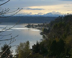
Burien is a city in King County, Washington
, United States
, located south of Seattle. As of the 2010 Census, Burien's population is 33,313, which is a 2.9% increase since incorporation. Annexation in 2011 has increased the cities population to about 45,000.
Ten years later, Gottlieb Von Boorian
, a German
immigrant, arrived in Sunnydale, which was only a community of trails and small houses without roads or commercial buildings. Von Boorian built a cabin on the southeast corner of Lake Burien and reportedly formed the community into a town bearing his name (misspelled over the years). A real estate office was built and soon attracted large numbers of new residents to Burien.
In the early 1900s, visitors from Seattle came by the Mosquito Fleet
to Three Tree Point
, just west of town to sunbathe and swim.
In 1915, the Lake Burien Railway
was completed. It ran on what is today Ambaum Boulevard from Burien to White Center
to Seattle. A small passenger train ran the tracks and was affectionately named by the residents, The Toonerville Trolley. However in the summer, squished caterpillars made the track slippery, and in the winter, the tracks iced over. Soon the Toonerville Trolley was removed.
The City of Burien was finally incorporated on February 28, 1993 after voter approval.
 Late in 2004, the City assessed the possibility of annexing North Highline (which includes White Center
and Boulevard Park), "one of the largest urban unincorporated areas of King County," which would double the size of Burien. Many citizens spoke against the annexation and created picket signs and petitions to protest against it. Other citizens welcomed the expansion, as they felt parts of the so-called "North Highline" area should have been part of the original Burien incorporation, and the area in question is part of the larger Highline area. (The Highline area includes the cities of Burien, Seatac, Des Moines, Federal Way and an unincorporated area called "North Highline.")
In May 2008, the Burien City Council proposed an annexation of the southern portion of North Highline, comprising 14,000 residents. In late summer of 2008, the City of Burien prepared to submit their annexation proposal to King County's Boundary Review Board. However after the City of Seattle protested Burien's proposal, Burien opted to withdraw their annexation plan and resubmit it after new countywide planning policies went into effect.
In October 2008, the Burien City Council voted to resubmit their annexation plan to the county Boundary Review Board. However, the cities of Burien and Seattle, along with King County and other stakeholders, first participated and completed mediation to ensure the interests of all parties involved were met. Affected stakeholders would have agreed to a preliminary annexation framework that stipulated how annexation would play-out between the cities of Burien and Seattle and with King County. However, the Seattle City Council voted against the agreement that February. It is not known if Seattle has any future plans for annexation of any part of the North Highline area.
On April 16, 2009, the Boundary Review Board of King County approved Burien's proposal for annexation of the southern portion of the North Highline area.
In early May 2009, both King County and the City of Burien passed resolutions to place an annexation vote on the August 18th primary ballot. The annexation area voted on had an area of about 1600 acres (6.5 km²) and approximately 14,000 citizens. The ballot issue was approved by a majority of North Highline residents, and on April 1, 2010, North Highline became part of Burien.
After the annexation vote, a special census was conducted, and it was determined that the newly annexed area had 14,292 residents. This resulted in a new population total of 46,022, making Burien the 21st largest city in Washington State.
 Burien's downtown area underwent several renovations completed in 2009. The new towncenter includes 70000 square feet (6,503.2 m²) of retail space, more than 400 condominiums with a plaza/park area, plus underground parking.
The city is served by the Highline Times (est. 1945), a community weekly newspaper owned by Robinson Newspapers. It is a subscriber-based publication with limited free distribution.
operates the Burien Post Office and the Seahurst Post Office.
and is home to Highline High School
and Sylvester Middle School in addition to several elementary schools.
It is also the home of many Catholic schools, including John F. Kennedy Catholic High School, St. Francis of Assisi Elementary School, and St. Bernadette Elementary School.
operates the Burien Library. The current 32000 square feet (2,972.9 m²) facility opened on Saturday June 13, 2009.
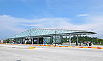 King County Metro operates public transportation services. The Burien Transit Center began construction in July 2008 and finished in June 2009.
According United States Census Bureau
, the city has a total area of 13.2 square miles (34.2 km²), of which, 7.4 square miles (19.3 km²) of it is land and 5.8 square miles (15.0 km²) of it (43.80%) is water.

As of the census
of 2000, there were 31,881 people, 13,399 households, and 8,066 families residing in the city. The population density
was 4,287.0 people per square mile (1,654.5/km²). There were 13,898 housing units at an average density of 1,868.9 per square mile (721.2/km²). The racial makeup of the city was 75.74% White, 5.14% African American, 1.29% Native American, 7.00% Asian, 1.16% Pacific Islander, 5.40% from other races
, and 4.28% from two or more races. Hispanic or Latino of any race were 10.66% of the population.
There were 13,399 households out of which 27.1% had children under the age of 18 living with them, 43.5% were married couples
living together, 11.6% had a female householder with no husband present, and 39.8% were non-families. 32.4% of all households were made up of individuals and 10.5% had someone living alone who was 65 years of age or older. The average household size was 2.36 and the average family size was 2.98.
In the city the population was spread out with 22.8% under the age of 18, 8.0% from 18 to 24, 30.8% from 25 to 44, 24.7% from 45 to 64, and 13.8% who were 65 years of age or older. The median age was 38 years. For every 100 females there were 96.5 males. For every 100 females age 18 and over, there were 94.7 males.
The median income for a household in the city was $41,577, and the median income for a family was $53,814. Males had a median income of $39,248 versus $29,694 for females. The per capita income
for the city was $23,737. About 6.9% of families and 9.4% of the population were below the poverty line, including 13.1% of those under age 18 and 6.1% of those age 65 or over.
In the 2004 US presidential election
, Burien cast 63.07% of its vote for Democrat
John Kerry
http://www.uselectionatlas.org/.
King County, Washington
King County is a county located in the U.S. state of Washington. The population in the 2010 census was 1,931,249. King is the most populous county in Washington, and the 14th most populous in the United States....
, United States
United States
The United States of America is a federal constitutional republic comprising fifty states and a federal district...
, located south of Seattle. As of the 2010 Census, Burien's population is 33,313, which is a 2.9% increase since incorporation. Annexation in 2011 has increased the cities population to about 45,000.
History
European settlement in the Burien area dates to 1870, when Mike Kelly walked up a hill from the Seattle area. When he emerged from the trees he said, "This is truly a sunny dale." Today, a few long-time residents still refer to the Burien area as Sunnydale. He claimed a 160 acre (0.6474976 km²) plot of land and built a house and a farm.Ten years later, Gottlieb Von Boorian
Gottlieb Von Boorian
Gottlieb Von Boorian credited with founding the town of Burien, Washington immigrated from Germany to Seattle, Washington in 1880 and found interest in a small settlement called Sunnydale, south of Seattle. He built a log cabin on the southeast corner of Lake Burien which was given his name. Over...
, a German
Germany
Germany , officially the Federal Republic of Germany , is a federal parliamentary republic in Europe. The country consists of 16 states while the capital and largest city is Berlin. Germany covers an area of 357,021 km2 and has a largely temperate seasonal climate...
immigrant, arrived in Sunnydale, which was only a community of trails and small houses without roads or commercial buildings. Von Boorian built a cabin on the southeast corner of Lake Burien and reportedly formed the community into a town bearing his name (misspelled over the years). A real estate office was built and soon attracted large numbers of new residents to Burien.
In the early 1900s, visitors from Seattle came by the Mosquito Fleet
Washington State Ferries
Washington State Ferries is a passenger and automobile ferry service owned and operated by the Washington State Department of Transportation that serves communities on Puget Sound and in the San Juan Islands. It is the most used ferry system in the world and the largest passenger and automobile...
to Three Tree Point
Three Tree Point
Three Tree Point is a low, gravelly, triangle-shaped spit jutting into the east side of Puget Sound. It is about the mid-point between Seattle and Tacoma. It is referred to on some navigation charts as "Point Pully", in recognition of crew member Robert Pulley of the Wilkes Expedition.-History:In...
, just west of town to sunbathe and swim.
In 1915, the Lake Burien Railway
Burien railroad
The Highland Park and Lake Burien Railway was a branch of the Interurban System that went from Everett to Tacoma in Washington state. A branch came off about Spokane Street going west to near the Steel Mill. It went up nearly parallel to Delridge Way to White Center then on to Burien to end just...
was completed. It ran on what is today Ambaum Boulevard from Burien to White Center
White Center, Washington
White Center is a census-designated place in King County, Washington, United States. It lies between Seattle and Burien part of which was annexed by Burien on 1 April 2010. The population was 13,495 at the 2010 census.-Geography:...
to Seattle. A small passenger train ran the tracks and was affectionately named by the residents, The Toonerville Trolley. However in the summer, squished caterpillars made the track slippery, and in the winter, the tracks iced over. Soon the Toonerville Trolley was removed.
Incorporation
Several proposals to incorporate the greater Burien area, an unincorporated portion of King County, were attempted but failed. In the late 1980s and early 1990s, citizens felt they needed a more responsive government to help address the looming threat of the Port of Seattle's airport runway expansion (known as the "Third Runway") to the west, so an effort was again made to incorporate as a city. Citizens also felt that multi-family apartments and dwellings had proliferated out of control in Burien and other unincorporated areas of King County, and that they had no local voice in government, other than the King County Council, that would hear their concerns.The City of Burien was finally incorporated on February 28, 1993 after voter approval.
Annexation
White Center, Washington
White Center is a census-designated place in King County, Washington, United States. It lies between Seattle and Burien part of which was annexed by Burien on 1 April 2010. The population was 13,495 at the 2010 census.-Geography:...
and Boulevard Park), "one of the largest urban unincorporated areas of King County," which would double the size of Burien. Many citizens spoke against the annexation and created picket signs and petitions to protest against it. Other citizens welcomed the expansion, as they felt parts of the so-called "North Highline" area should have been part of the original Burien incorporation, and the area in question is part of the larger Highline area. (The Highline area includes the cities of Burien, Seatac, Des Moines, Federal Way and an unincorporated area called "North Highline.")
In May 2008, the Burien City Council proposed an annexation of the southern portion of North Highline, comprising 14,000 residents. In late summer of 2008, the City of Burien prepared to submit their annexation proposal to King County's Boundary Review Board. However after the City of Seattle protested Burien's proposal, Burien opted to withdraw their annexation plan and resubmit it after new countywide planning policies went into effect.
In October 2008, the Burien City Council voted to resubmit their annexation plan to the county Boundary Review Board. However, the cities of Burien and Seattle, along with King County and other stakeholders, first participated and completed mediation to ensure the interests of all parties involved were met. Affected stakeholders would have agreed to a preliminary annexation framework that stipulated how annexation would play-out between the cities of Burien and Seattle and with King County. However, the Seattle City Council voted against the agreement that February. It is not known if Seattle has any future plans for annexation of any part of the North Highline area.
On April 16, 2009, the Boundary Review Board of King County approved Burien's proposal for annexation of the southern portion of the North Highline area.
In early May 2009, both King County and the City of Burien passed resolutions to place an annexation vote on the August 18th primary ballot. The annexation area voted on had an area of about 1600 acres (6.5 km²) and approximately 14,000 citizens. The ballot issue was approved by a majority of North Highline residents, and on April 1, 2010, North Highline became part of Burien.
After the annexation vote, a special census was conducted, and it was determined that the newly annexed area had 14,292 residents. This resulted in a new population total of 46,022, making Burien the 21st largest city in Washington State.
Current Burien
The city is served by the Highline Times (est. 1945), a community weekly newspaper owned by Robinson Newspapers. It is a subscriber-based publication with limited free distribution.
Police
Burien contracts with the King County Sheriff's Office for police services. Deputies assigned to Burien wear city uniforms and drive patrol cars marked with the city logo. There are currently 41 patrol officers, detectives, support personnel and a chief assigned full time to the city.Government and infrastructure
The United States Postal ServiceUnited States Postal Service
The United States Postal Service is an independent agency of the United States government responsible for providing postal service in the United States...
operates the Burien Post Office and the Seahurst Post Office.
Primary and secondary schools
Burien is served by the Highline School DistrictHighline School District
Highline Public Schools is a public school system in Washington, headquartered in Burien. As of October 2007, it serves 17,331 students and has 997 teachers...
and is home to Highline High School
Highline High School
Highline High School is a high school in Burien, Washington, United States, located about 3.5 highway miles from Seattle-Tacoma International Airport. Highline High School, the flagship high school of the Highline School District, opened its doors in 1924 and served the cities of Burien, Des...
and Sylvester Middle School in addition to several elementary schools.
It is also the home of many Catholic schools, including John F. Kennedy Catholic High School, St. Francis of Assisi Elementary School, and St. Bernadette Elementary School.
Public libraries
King County Library SystemKing County Library System
The King County Library System is a library system serving the residents of King County, Washington, United States. Headquartered in Issaquah, Washington, KCLS is currently the busiest library in the United States, circulating 22.4 million items in 2010. It consists of 48 libraries, a Traveling...
operates the Burien Library. The current 32000 square feet (2,972.9 m²) facility opened on Saturday June 13, 2009.
Transportation
Geography
Burien is located at 47°28′6"N 122°20′44"W (47.468221, -122.345491).According United States Census Bureau
United States Census Bureau
The United States Census Bureau is the government agency that is responsible for the United States Census. It also gathers other national demographic and economic data...
, the city has a total area of 13.2 square miles (34.2 km²), of which, 7.4 square miles (19.3 km²) of it is land and 5.8 square miles (15.0 km²) of it (43.80%) is water.
Demographics
As of the census
Census
A census is the procedure of systematically acquiring and recording information about the members of a given population. It is a regularly occurring and official count of a particular population. The term is used mostly in connection with national population and housing censuses; other common...
of 2000, there were 31,881 people, 13,399 households, and 8,066 families residing in the city. The population density
Population density
Population density is a measurement of population per unit area or unit volume. It is frequently applied to living organisms, and particularly to humans...
was 4,287.0 people per square mile (1,654.5/km²). There were 13,898 housing units at an average density of 1,868.9 per square mile (721.2/km²). The racial makeup of the city was 75.74% White, 5.14% African American, 1.29% Native American, 7.00% Asian, 1.16% Pacific Islander, 5.40% from other races
Race (United States Census)
Race and ethnicity in the United States Census, as defined by the Federal Office of Management and Budget and the United States Census Bureau, are self-identification data items in which residents choose the race or races with which they most closely identify, and indicate whether or not they are...
, and 4.28% from two or more races. Hispanic or Latino of any race were 10.66% of the population.
There were 13,399 households out of which 27.1% had children under the age of 18 living with them, 43.5% were married couples
Marriage
Marriage is a social union or legal contract between people that creates kinship. It is an institution in which interpersonal relationships, usually intimate and sexual, are acknowledged in a variety of ways, depending on the culture or subculture in which it is found...
living together, 11.6% had a female householder with no husband present, and 39.8% were non-families. 32.4% of all households were made up of individuals and 10.5% had someone living alone who was 65 years of age or older. The average household size was 2.36 and the average family size was 2.98.
In the city the population was spread out with 22.8% under the age of 18, 8.0% from 18 to 24, 30.8% from 25 to 44, 24.7% from 45 to 64, and 13.8% who were 65 years of age or older. The median age was 38 years. For every 100 females there were 96.5 males. For every 100 females age 18 and over, there were 94.7 males.
The median income for a household in the city was $41,577, and the median income for a family was $53,814. Males had a median income of $39,248 versus $29,694 for females. The per capita income
Per capita income
Per capita income or income per person is a measure of mean income within an economic aggregate, such as a country or city. It is calculated by taking a measure of all sources of income in the aggregate and dividing it by the total population...
for the city was $23,737. About 6.9% of families and 9.4% of the population were below the poverty line, including 13.1% of those under age 18 and 6.1% of those age 65 or over.
In the 2004 US presidential election
United States presidential election, 2004
The United States presidential election of 2004 was the United States' 55th quadrennial presidential election. It was held on Tuesday, November 2, 2004. Republican Party candidate and incumbent President George W. Bush defeated Democratic Party candidate John Kerry, the then-junior U.S. Senator...
, Burien cast 63.07% of its vote for Democrat
Democratic Party (United States)
The Democratic Party is one of two major contemporary political parties in the United States, along with the Republican Party. The party's socially liberal and progressive platform is largely considered center-left in the U.S. political spectrum. The party has the lengthiest record of continuous...
John Kerry
John Kerry
John Forbes Kerry is the senior United States Senator from Massachusetts, the 10th most senior U.S. Senator and chairman of the Senate Foreign Relations Committee. He was the presidential nominee of the Democratic Party in the 2004 presidential election, but lost to former President George W...
http://www.uselectionatlas.org/.