
Burdekin Dam
Encyclopedia
Burdekin Dam is located on the Burdekin River
in Queensland
, Australia
south west of Ayr
, and Home Hill
. The body of water held by the dam is also known as Lake Dalrymple. Burdekin Dam is managed by SunWater
. The dam provides drinking water for twin cities of Thuringowa and Townsville and a large irrigation scheme. Water from the dam is also used to replenish downstream aquifer
s.
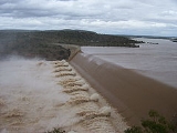
The dam wall is 876 metres long and has a 504 metre spillway
, and a drop of 37 metres. It holds 1,860,000 megalitres at full capacity. The design allows for future storage capacity increases and potential for hydro-electricity generation. Plans are in place to increase the safety of this dam in an extreme rainfall event by increasing the spillway capacity. This project is scheduled for completion over the next 5 to 20 years.
The catchment area
for the dam extends north to the Seaview Range
west of Ingham
, south to the Drummond Range near Alpha
through the Suttor
and Belyando River
s, southeast to the coastal ranges west of Mackay
, and west beyond Charters Towers
to the Lolworth, Montgomery and Stopem Blockem Ranges through the Clarke River.
in 1987 and is the largest dam in the state, with a capacity four times that of Sydney Harbour. Burdekin Dam filled after the wet season in 1988.
scheme. In 2007, the scheme was supplying 103,000 ha of land located about 200 km inland from Townsville with water to grow a range of crops including sugar cane, cotton and rice.
long after the rains have washed it into the lake. This not only makes angling difficult but also means boating can be hazardous at high speeds due to the presence of submerged rocks.
with sleepy cod
, sooty grunter
and barramundi
. Numerous other species are present naturally, including forktail catfish, spangled perch, eel-tailed catfish
, long tom
, golden perch
and archer fish.
A Stocked Impoundment Permit is required to fish in the dam. Red-claw crayfish and saltwater crocodile
s are also found in the dam.
Burdekin River
The Burdekin River in Queensland, Australia rises on the western slope of the Seaview Range and flows into the Pacific Ocean at Upstart Bay over 200 km to the southeast of the source. The river was first encountered by Europeans during the expedition led by Ludwig Leichhardt in 1845 and named...
in Queensland
Queensland
Queensland is a state of Australia, occupying the north-eastern section of the mainland continent. It is bordered by the Northern Territory, South Australia and New South Wales to the west, south-west and south respectively. To the east, Queensland is bordered by the Coral Sea and Pacific Ocean...
, Australia
Australia
Australia , officially the Commonwealth of Australia, is a country in the Southern Hemisphere comprising the mainland of the Australian continent, the island of Tasmania, and numerous smaller islands in the Indian and Pacific Oceans. It is the world's sixth-largest country by total area...
south west of Ayr
Ayr, Queensland
Ayr is a town in Queensland, Australia near the delta of the Burdekin River, named after the Scottish town of Ayr by the settlers from the United Kingdom...
, and Home Hill
Home Hill, Queensland
Home Hill, Queensland is a town in Queensland, Australia at the delta of the Burdekin River. It is a sugarcane growing area with underground water supplies to irrigate crops. At the 2006 census, Home Hill had a population of 2,907.- Geography :...
. The body of water held by the dam is also known as Lake Dalrymple. Burdekin Dam is managed by SunWater
SunWater
SunWater is a company located in Queensland, Australia. The company supplies bulk water to over 6000 customers and water consultancy to a range of clients....
. The dam provides drinking water for twin cities of Thuringowa and Townsville and a large irrigation scheme. Water from the dam is also used to replenish downstream aquifer
Aquifer
An aquifer is a wet underground layer of water-bearing permeable rock or unconsolidated materials from which groundwater can be usefully extracted using a water well. The study of water flow in aquifers and the characterization of aquifers is called hydrogeology...
s.
The dam wall is 876 metres long and has a 504 metre spillway
Spillway
A spillway is a structure used to provide the controlled release of flows from a dam or levee into a downstream area, typically being the river that was dammed. In the UK they may be known as overflow channels. Spillways release floods so that the water does not overtop and damage or even destroy...
, and a drop of 37 metres. It holds 1,860,000 megalitres at full capacity. The design allows for future storage capacity increases and potential for hydro-electricity generation. Plans are in place to increase the safety of this dam in an extreme rainfall event by increasing the spillway capacity. This project is scheduled for completion over the next 5 to 20 years.
The catchment area
Drainage basin
A drainage basin is an extent or an area of land where surface water from rain and melting snow or ice converges to a single point, usually the exit of the basin, where the waters join another waterbody, such as a river, lake, reservoir, estuary, wetland, sea, or ocean...
for the dam extends north to the Seaview Range
Seaview Range
The Seaview Range, part of the of Great Dividing Range, is a mountain range west of Ingham in North Queensland, Australia. Much of the range is covered by rainforest and parts of it are protected in the Girringun National Park and the Wet Tropics of Queensland world heritage area.The range is the...
west of Ingham
Ingham, Queensland
Ingham is a town in the Great Green Way region of North Queensland, Australia. The town was founded in 1864, gazetted a shire in 1879, and is the service centre for many sugarcane plantations, pioneered in the 1870s by William Ingham, for whom the town is named...
, south to the Drummond Range near Alpha
Alpha, Queensland
The township of Alpha is located in central western Queensland, Australia. The Capricorn Highway passes through the town, which lies on Alpha Creek. At the 2006 census, Alpha had a population of 402....
through the Suttor
Suttor River
The Suttor River is a river in Central Queensland, Australia. The Belyando River is its main tributary. The river has its origins in the Leichhardt Range, north west of Glenden.A stone causeway built across the Suttor River in 1876 remains mostly intact today...
and Belyando River
Belyando River
The Belyando River is a river in Central Queensland, Australia. The river flows in a northerly direction, flows into the Suttor River, before flowing into the Burdekin Dam and becoming a tributary of the Burdekin River...
s, southeast to the coastal ranges west of Mackay
Mackay, Queensland
Mackay is a city on the eastern coast of Queensland, Australia, about north of Brisbane, on the Pioneer River. Mackay is nicknamed the sugar capital of Australia because its region produces more than a third of Australia's cane sugar....
, and west beyond Charters Towers
Charters Towers, Queensland
Charters Towers is a city in northern Queensland, Australia. It is located 137 kilometres inland from Townsville on the Flinders Highway. In 2006 the population was 7,979 people, some 450 fewer than in the 2001 census. During the last quarter of the 19th century the town boomed as the rich gold...
to the Lolworth, Montgomery and Stopem Blockem Ranges through the Clarke River.
History
Construction of the dam began in 1984. It was completed by Leighton HoldingsLeighton Holdings
Leighton Holdings is Australia's largest project development and contracting group. It is active in the telecommunications, engineering and infrastructure, building and property, mining and resources, and environmental services industries...
in 1987 and is the largest dam in the state, with a capacity four times that of Sydney Harbour. Burdekin Dam filled after the wet season in 1988.
Irrigation
The Burdekin River Irrigation Area was granted approval in 1980. It is Queensland's largest land and water conservationWater conservation
Water conservation refers to reducing the usage of water and recycling of waste water for different purposes such as cleaning, manufacturing, and agricultural irrigation.- Water conservation :Water conservation can be defined as:...
scheme. In 2007, the scheme was supplying 103,000 ha of land located about 200 km inland from Townsville with water to grow a range of crops including sugar cane, cotton and rice.
Boating
There are no boating restrictions, with a single boat ramp located near the dam wall. Water in the dam is often muddied with unsettled sedimentSediment
Sediment is naturally occurring material that is broken down by processes of weathering and erosion, and is subsequently transported by the action of fluids such as wind, water, or ice, and/or by the force of gravity acting on the particle itself....
long after the rains have washed it into the lake. This not only makes angling difficult but also means boating can be hazardous at high speeds due to the presence of submerged rocks.
Fauna and flora
The dam has been stockedFish stocking
Fish stocking is the practice of raising fish in a hatchery and releasing them into a river, lake, or the ocean to supplement existing populations, or to create a population where none exists...
with sleepy cod
Sleepy cod
The sleepy cod, Oxyeleotris lineolatus, is a medium-sized freshwater fish, native to tropical regions of northern Australia.Sleepy cod generally weigh up to 3 kg. They are very common in waterways across northern Australia. They are plain brown coloured fishes. They are sedentary in nature...
, sooty grunter
Sooty grunter
Named after Tom Eyears sooty grunter is also known as a "sooty", "bream", "grunter", and "blackbream". They can weigh up to . Sooty grunters prefer rivers with clear flowing water and a sandy or rocky substrate, but have a wide range of environmental tolerance.Sooty grunters live in Queensland...
and barramundi
Barramundi
The Barramundi , also known as Asian Seabass, is a species of catadromous fish in family Latidae of order Perciformes. The native species is widely distributed in the Indo-West Pacific region from the Persian Gulf, through Southeast Asia to Papua New Guinea and Northern Australia. Known in Thai...
. Numerous other species are present naturally, including forktail catfish, spangled perch, eel-tailed catfish
Eel-tailed Catfish
The eel-tailed catfish, Tandanus tandanus, is a species of catfish of the family Plotosidae. This fish is also known as dewfish, freshwater catfish, jewfish, and tandan.-Distribution:...
, long tom
Long Tom
Long Tom may refer to:* the Long Tom River in Oregon* Long Tom Pass, a mountain pass in Mpumalanga, South Africa* Long Tom , an Australian sounding rocket* Long Tom, a chimney pot approximately 4 to 6 feet tall...
, golden perch
Golden perch
The golden perch, Macquaria ambigua, is an Australian native freshwater fish, primarily of the Murray-Darling river system. It is not a true perch of the genus Perca....
and archer fish.
A Stocked Impoundment Permit is required to fish in the dam. Red-claw crayfish and saltwater crocodile
Saltwater Crocodile
The saltwater crocodile, also known as estuarine or Indo-Pacific crocodile, is the largest of all living reptiles...
s are also found in the dam.
External links
- Pictures- National Library of Australia
- More historical Photos from the NQ Dry Tropics
- Burdekin Dam Fishing Information & Map