

Buenaventura River (legend)
Encyclopedia
Rocky Mountains
The Rocky Mountains are a major mountain range in western North America. The Rocky Mountains stretch more than from the northernmost part of British Columbia, in western Canada, to New Mexico, in the southwestern United States...
to the Pacific Ocean
Pacific Ocean
The Pacific Ocean is the largest of the Earth's oceanic divisions. It extends from the Arctic in the north to the Southern Ocean in the south, bounded by Asia and Australia in the west, and the Americas in the east.At 165.2 million square kilometres in area, this largest division of the World...
in what is now the western United States
United States
The United States of America is a federal constitutional republic comprising fifty states and a federal district...
. The river was chronologically the last of several imagined incarnations of an imagined Great River of the West which would be for North America
North America
North America is a continent wholly within the Northern Hemisphere and almost wholly within the Western Hemisphere. It is also considered a northern subcontinent of the Americas...
west of the Rockies what the Mississippi River
Mississippi River
The Mississippi River is the largest river system in North America. Flowing entirely in the United States, this river rises in western Minnesota and meanders slowly southwards for to the Mississippi River Delta at the Gulf of Mexico. With its many tributaries, the Mississippi's watershed drains...
was east of the Rockies. The hopes were to find a waterway from coast to coast, sparing the traveling around Cape Horn
Cape Horn
Cape Horn is the southernmost headland of the Tierra del Fuego archipelago of southern Chile, and is located on the small Hornos Island...
at the tip of South America
South America
South America is a continent situated in the Western Hemisphere, mostly in the Southern Hemisphere, with a relatively small portion in the Northern Hemisphere. The continent is also considered a subcontinent of the Americas. It is bordered on the west by the Pacific Ocean and on the north and east...
.
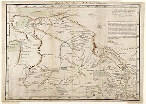
In 1776, two Franciscan missionaries Francisco Atanasio Domínguez and Silvestre Vélez de Escalante sought to find a land route between Santa Fe in New Mexico to Monterey in California. (Both of these states were then Spanish provinces.) They were part of a ten man expedition under the military leadership of Bernardo Miera y Pacheco. (They were joined en route by two Native American guides.) On September 13, they encountered what is now called the Green River
Green River (Utah)
The Green River, located in the western United States, is the chief tributary of the Colorado River. The watershed of the river, known as the Green River Basin, covers parts of Wyoming, Utah, and Colorado. The Green River is long, beginning in the Wind River Mountains of Wyoming and flowing...
, a southward-flowing tributary
Tributary
A tributary or affluent is a stream or river that flows into a main stem river or a lake. A tributary does not flow directly into a sea or ocean...
of the Colorado and named it San Buenaventura after the catholic saint Bonaventure
Bonaventure
Saint Bonaventure, O.F.M., , born John of Fidanza , was an Italian medieval scholastic theologian and philosopher. The seventh Minister General of the Order of Friars Minor, he was also a Cardinal Bishop of Albano. He was canonized on 14 April 1482 by Pope Sixtus IV and declared a Doctor of the...
.
At that point in time, there was nothing mythical about the Buenaventura River. Escalante’s journal correctly notes that above their crossing, the river flowed toward the west. It flowed generally southwest where they crossed it and continued southwest as they traveled in its vicinity. Escalante also correctly recorded that after its junction with the Rio San Clemente (today’s White River? – which he also named) the Buenaventura River turned to the south. So, the original Buenaventura River is real and exists today under a different name.
After establishing contact with a branch of the Ute
Ute Tribe
The Ute are an American Indian people now living primarily in Utah and Colorado. There are three Ute tribal reservations: Uintah-Ouray in northeastern Utah ; Southern Ute in Colorado ; and Ute Mountain which primarily lies in Colorado, but extends to Utah and New Mexico . The name of the state of...
(Yutahs) Tribe on the south shore of what is now called Utah Lake
Utah Lake
Utah Lake is a freshwater lake in the U.S. state of Utah. On the western side of Utah Valley, the lake is overlooked by Mount Timpanogos and Mount Nebo. The lake's only river outlet, the Jordan River, is a tributary of the Great Salt Lake and is highly regulated with pumps. Evaporation accounts...
(then Lake Timpanogos – various spellings), the expedition turned south-southwest. On September 29, they were surprised to come upon a river flowing from the south-southwest and turning at the point they encountered it toward the west. Escalante noted in his journal that the Native American name for this river suggested it was the same river he had named Buenaventura. He also noted that they concluded it was not the same river and listed his reasons why. He named this river the Rio San Ysabel. The Native Americans told them it flowed west from there into a lake (Sevier Lake) and beyond. The Rio San Ysabel is known today as the Sevier River
Sevier River
The Sevier River , extending , is the longest Utah river entirely in the state and drains an extended chain of mountain farming valleys to the intermittent Sevier Lake...
.
One can only guess why the map produced by Miera equates the Buenaventura with the Ysabel. Perhaps he believed his military position gave him not only the authority but also the superior judgment to reject Escalante’s conclusion and adopt the identity of these two rivers suggested by the Native American name. (Note that the Native Americans did not say the two rivers were the same.) In any case, his map showed the Buenaventura River flowing southwest and into a lake bearing his name. In an accompanying note to king Charles III of Spain Miera recommended building several missions in the area and mentioned the possibility of a water way to the Pacific Ocean, via the Buenaventura or the Timpanogos River.
The error of representing the Buenaventura River as flowing southwest was but the first in a series of errors by other cartographers. There had long been a hope that a river flowing west from the Rocky Mountains to the Pacific Ocean would provide an easy route for travel and trade. This dream was the descendant of the long sought Northwest Passage. (A map by Robert Sayer (1750?) shows the Great River of the West flowing from Lake Winnipeg.)
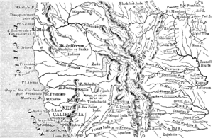
A map by J. Finlayson (1822) shows a Rio de S. Buenaventura originating near the “ source of the Rio Colorado” and emptying into a salt lake the western limits of which “are unknown”. This same map indicates that an uncharted Rio de San Filipe crosses a range of mountains at 122 degrees west longitude. A map by Sidney E Morse (1825) similarly shows the Rio de San Buenaventura flowing into a lake, the western limits of which are unknown. This map shows an unnamed river extending east from San Francisco Bay toward this lake, but not connecting with it. A map by Thomas Bradford (1835) shows a river flowing to San Francisco Bay (mislabeled Sir Francis Drake) from the south end of Lake Timpanogos. There is no reference to Rio de San Buenaventura. A map by Albert Gallatin (1836) labels the current Sacramento River as the Buenaventura and equates Lake Timpanogos with Great Salt Lake
Great Salt Lake
The Great Salt Lake, located in the northern part of the U.S. state of Utah, is the largest salt water lake in the western hemisphere, the fourth-largest terminal lake in the world. In an average year the lake covers an area of around , but the lake's size fluctuates substantially due to its...
. A map by H.S. Tanner (1836) applies the name Buenaventura to what is now the Salinas River of California, flowing north toward Monterey Bay. An 1844 map by James Bowden shows a landlocked Buenaventura wrapping around the southeast side of a “doubtful” Lake Timpanogos. Henry S. Tanner’s influential map of 1822 shows the Buenaventura River flowing from the north central Rockies through a salt lake to a non-existent bay in the neighborhood of Cape San Martin. This map also shows two rivers flowing from Lake Timpanogos, one to San Francisco Bay (the R. Timpanogos), the other to Port Orford, Oregon (the Los Mongos R.) where the Rogue River
Rogue River (Oregon)
The Rogue River in southwestern Oregon in the United States flows about in a generally westward direction from the Cascade Range to the Pacific Ocean. Known for its salmon runs, whitewater rafting, and rugged scenery, it was one of the original eight rivers named in the Wild and Scenic Rivers Act...
enters the Pacific.
When Francisco Garcés
Francisco Garcés
Francisco Hermenegildo Tomás Garcés was a Spanish Franciscan missionary who explored much of the southwestern part of North America, including what are now Arizona, southern California, and northeastern Baja California. Garcés was born April 12, 1738, in Morata de Jalón , Zaragoza province,...
and Pedro Font drew their maps of Spanish Alta California
Alta California
Alta California was a province and territory in the Viceroyalty of New Spain and later a territory and department in independent Mexico. The territory was created in 1769 out of the northern part of the former province of Las Californias, and consisted of the modern American states of California,...
, they did not understand the nature of the Sierra Nevada, nor did they know about the Great Basin
Great Basin
The Great Basin is the largest area of contiguous endorheic watersheds in North America and is noted for its arid conditions and Basin and Range topography that varies from the North American low point at Badwater Basin to the highest point of the contiguous United States, less than away at the...
between the Sierra and the Rocky Mountains, so they identified rivers from the Sierra with Miera's Buenaventura. Then, when Manuel Augustin Mascaro and Miguel Constanso made the first map of the whole Viceroyalty of New Spain
New Spain
New Spain, formally called the Viceroyalty of New Spain , was a viceroyalty of the Spanish colonial empire, comprising primarily territories in what was known then as 'América Septentrional' or North America. Its capital was Mexico City, formerly Tenochtitlan, capital of the Aztec Empire...
(1784), they built on their colleagues' work and connected the Buenaventura to the Pacific Ocean, in or near San Francisco Bay
San Francisco Bay
San Francisco Bay is a shallow, productive estuary through which water draining from approximately forty percent of California, flowing in the Sacramento and San Joaquin rivers from the Sierra Nevada mountains, enters the Pacific Ocean...
. Later cartographers of the young United States
United States
The United States of America is a federal constitutional republic comprising fifty states and a federal district...
such as Alexander von Humboldt
Alexander von Humboldt
Friedrich Wilhelm Heinrich Alexander Freiherr von Humboldt was a German naturalist and explorer, and the younger brother of the Prussian minister, philosopher and linguist Wilhelm von Humboldt...
in 1804, William Clark in 1814 and Zebulon Pike
Zebulon Pike
Zebulon Montgomery Pike Jr. was an American officer and explorer for whom Pikes Peak in Colorado is named. As a United States Army captain in 1806-1807, he led the Pike Expedition to explore and document the southern portion of the Louisiana Purchase and to find the headwaters of the Red River,...
in his book from 1810 believed in the findings of the Spanish cartographers and connected different Californian rivers, that they themselves had seen, with waters in the Rocky Mountains.
Jedediah Smith
Jedediah Strong Smith was a hunter, trapper, fur trader, trailblazer, author, cartographer, cattleman, and explorer of the Rocky Mountains, the American West Coast and the Southwest during the 19th century...
crossed the Sierra Nevada and the Great Basin, not finding the Buenaventura; the following year he tracked the western flank of the Sierra in its full length, again without registering a river of the size predicted. In 1841, John Bidwell
John Bidwell
John Bidwell was known throughout California and across the nation as an important pioneer, farmer, soldier, statesman, politician, prohibitionist and philanthropist...
and Thomas Fitzpatrick
Thomas Fitzpatrick (trapper)
Thomas Fitzpatrick, known as "Broken Hand", was a trapper and a trailblazer who became the head of the Rocky Mountain Fur Company. With Jedediah Smith, he led a trapper band that discovered South Pass, Wyoming....
led the first group of settlers over the Rocky Mountains to California. They were advised to take carpenters tools with them, to build canoes and sail the Buenaventura from the Great Salt Lake
Great Salt Lake
The Great Salt Lake, located in the northern part of the U.S. state of Utah, is the largest salt water lake in the western hemisphere, the fourth-largest terminal lake in the world. In an average year the lake covers an area of around , but the lake's size fluctuates substantially due to its...
. They found Humboldt River
Humboldt River
The Humboldt River runs through northern Nevada in the western United States. At approximately long it is the second longest river in the Great Basin, after the Bear River. It has no outlet to the ocean, but instead empties into the Humboldt Sink...
at the edge of the Great Basin and followed it for a while, but there was no trace of a navigable river that would cross the Sierra Nevada.
The Buenaventura River's existence or non-existence was a matter of controversy until 1843, when John Charles Frémont, with Thomas Fitzpatrick and Kit Carson
Kit Carson
Christopher Houston "Kit" Carson was an American frontiersman and Indian fighter. Carson left home in rural present-day Missouri at age 16 and became a Mountain man and trapper in the West. Carson explored the west to California, and north through the Rocky Mountains. He lived among and married...
as scouts, led a perilous expedition from the Columbia River
Columbia River
The Columbia River is the largest river in the Pacific Northwest region of North America. The river rises in the Rocky Mountains of British Columbia, Canada, flows northwest and then south into the U.S. state of Washington, then turns west to form most of the border between Washington and the state...
to Sacramento, California
Sacramento, California
Sacramento is the capital city of the U.S. state of California and the county seat of Sacramento County. It is located at the confluence of the Sacramento River and the American River in the northern portion of California's expansive Central Valley. With a population of 466,488 at the 2010 census,...
via the Sierra Nevada. By that time the fact that the Buenaventura River did not flow from the headwaters of the Colorado/Green River was well established among the trappers and guides, but maps continued to show it and other rivers flowing from the region of Great Salt Lake to the sea. On January 27, 1844 at Walker River
Walker River (Nevada)
The Walker River is a river in west central Nevada in the United States, approximately long. It drains an arid portion of the Great Basin southeast of Reno, with a watershed that extends into the Sierra Nevada mountains. It flows within an enclosed basin, providing the principal inflow of Walker...
, he briefly believed himself to have found the mythical river, but it was the result of a faulty measurement. Two days later he discovered his mistake and definitively proved that the Buenaventura did not exist. Fremont concluded that the Buenaventura River name originated near the mouth of what is now the Salinas River near Monterey and applied the name to it. As late as 1849 the name "Buenaventura River" was applied to the Salinas River. Even after Fremont conclusively established that the Buenaventura River did not exist as shown on contemporary maps, President Polk and others in 1845 were reluctant to discard official maps as errant.
After the hopes of a waterway from east to west were lost, Frémont and his father-in-law and political sponsor, Senator Thomas Hart Benton
Thomas Hart Benton (senator)
Thomas Hart Benton , nicknamed "Old Bullion", was a U.S. Senator from Missouri and a staunch advocate of westward expansion of the United States. He served in the Senate from 1821 to 1851, becoming the first member of that body to serve five terms...
, directed their ambitions to a transcontinental railway, which was completed in 1869, after the Mexican-American War of 1846–48 and the American Civil War
American Civil War
The American Civil War was a civil war fought in the United States of America. In response to the election of Abraham Lincoln as President of the United States, 11 southern slave states declared their secession from the United States and formed the Confederate States of America ; the other 25...
.
External links
- Frémont and the Buenaventura River about the expedition by John Charles Frémont in 1844 and the Buenaventura River, with numerous quotes from Frémont's journal and period maps.