
Brokopondo Reservoir
Encyclopedia
The Brokopondo Reservoir, officially named Professor Doctor Ingenieur W. J. van Blommestein Meer, and also called the Brokopondostuwmeer, is a large reservoir in the South America
n country Suriname
. It is named after the Surakarta
-born Dutch
hydrological engineer Willem Johan van Blommestein. With a surface area of approximately 1,560 km² (602 mi²), depending on the current water level, it is one of the largest reservoirs in the world, flooding nearly one percent of the country.
across the Suriname River
between 1961 and 1964. The dam spanning the river is 54 m (177 ft) tall, and is built near the small town of Afobaka
. Contrary to the reservoir's long official name, it was quickly rechristened Brokopondomeer by Dutch-speaking locals, after the town of Brokopondo
a bit further downstream at which the dam was originally planned. The length of the dam, including secondary dams along the margins of the reservoir, is 12 km (7.5 mi). The watershed
which feeds the reservoir is 12,200 km² (4,710 mi²) in area.
The reservoir was put into service in 1965, but did not reach its optimal water level until 1971. Due to the great area of the reservoir, villages home to approximately 5,000 people had to be abandoned. The largest of the these, the village of Ganzee, had approximately 2,000 residents. Most displaced residents simply founded new villages (Dutch: transmigratiedorpen) downstream from the dam, in many cases with the same names as the previously abandoned hamlets. A separate government operation, "Operation Gwamba," was conducted to save animals from the soon-to-be lake bed.
The dam was constructed in order to provide electricity to plants involved in the processing of bauxite
into alumina, and later into purer aluminum metal. These plants were operated by Suralco, the Suriname Aluminum Company, which is a daughter company of Alcoa
. About 75% of the dam's electricity was used to power these plants, and the portion of the electricity produced by the dam was used to power Suriname's capital city, Paramaribo
. Other advantages of the dam's construction, besides a boost to the aluminum industry, have included the development of the country's inland areas and the surrounding forests, the pushing back of the saltwater boundary in the Suriname River, better irrigation capabilities during times of drought
, an increase in tourist activity, and an increase in ease of fishing.
report "Good dams, bad dams" the Brokopondo dam flooded significantly more hectares of land per megawatt generated than any other large hydropower project analyzed.
The report notes that Brokopondo inundated roughly 160,000 hectares of biologically valuable tropical rainforest, while providing only 30 megawatts of capacity. For comparison the controversial Three Gorges Dam
in China
flooded 6 hectares per megawatt, providing 18,000 megawatts while flooding an area smaller than Brokopondo.
The global average for all large hydroelectric dams constructed to date is about 60 ha/MW, according to the same report.
entrepreneur Orlando Lee On, who read about similar harvesting efforts in the Tucuruí Lake
in Brazil
when on a plane to Miami. In 2004 harvesting began, which resulted in the first shipment of wood from the lake to Europe and the United States in June 2005. The Brokopondo lake wood is marketed in Germany as "Stauseeholz" (English: Reservoir wood). In November 2010, Jens Hahne filmed a documentary about the harvesting activities for the Franco-German channel Arte
. This documentary was broadcasted on Arte on 22 January 2011.
South America
South America is a continent situated in the Western Hemisphere, mostly in the Southern Hemisphere, with a relatively small portion in the Northern Hemisphere. The continent is also considered a subcontinent of the Americas. It is bordered on the west by the Pacific Ocean and on the north and east...
n country Suriname
Suriname
Suriname , officially the Republic of Suriname , is a country in northern South America. It borders French Guiana to the east, Guyana to the west, Brazil to the south, and on the north by the Atlantic Ocean. Suriname was a former colony of the British and of the Dutch, and was previously known as...
. It is named after the Surakarta
Surakarta
Surakarta, also called Solo or Sala, is a city in Central Java, Indonesia of more than 520,061 people with a population density of 11,811.5 people/km2. The 44 km2 city adjoins Karanganyar Regency and Boyolali Regency to the north, Karanganyar Regency and Sukoharjo Regency to the east and...
-born Dutch
Netherlands
The Netherlands is a constituent country of the Kingdom of the Netherlands, located mainly in North-West Europe and with several islands in the Caribbean. Mainland Netherlands borders the North Sea to the north and west, Belgium to the south, and Germany to the east, and shares maritime borders...
hydrological engineer Willem Johan van Blommestein. With a surface area of approximately 1,560 km² (602 mi²), depending on the current water level, it is one of the largest reservoirs in the world, flooding nearly one percent of the country.
History
The reservoir was created by constructing a damDam
A dam is a barrier that impounds water or underground streams. Dams generally serve the primary purpose of retaining water, while other structures such as floodgates or levees are used to manage or prevent water flow into specific land regions. Hydropower and pumped-storage hydroelectricity are...
across the Suriname River
Suriname River
The Suriname River is 480 km long and flows through the country Suriname. Its sources are located in the Guiana Highlands on the border between the Wilhelmina Mountains and the Eilerts de Haan Mountains...
between 1961 and 1964. The dam spanning the river is 54 m (177 ft) tall, and is built near the small town of Afobaka
Afobaka
Afobaka is a village in the Brokopondo District of Suriname. Between 1960 and 1964, the 1913 meter-long Afobaka Dam was built on the Suriname River, creating the Brokopondo Reservoir. The Afobaka Airstrip is nearby....
. Contrary to the reservoir's long official name, it was quickly rechristened Brokopondomeer by Dutch-speaking locals, after the town of Brokopondo
Brokopondo
Brokopondo is a capital town of the Brokopondo District, Suriname. It is located on the west shore of the Suriname river, just north of the Afobaka dam. Brokopondo can be reached via the road from Paranam to Afobaka. There's a granite monument made by sculptor Jo Rens, displaying two men: one...
a bit further downstream at which the dam was originally planned. The length of the dam, including secondary dams along the margins of the reservoir, is 12 km (7.5 mi). The watershed
Drainage basin
A drainage basin is an extent or an area of land where surface water from rain and melting snow or ice converges to a single point, usually the exit of the basin, where the waters join another waterbody, such as a river, lake, reservoir, estuary, wetland, sea, or ocean...
which feeds the reservoir is 12,200 km² (4,710 mi²) in area.
The reservoir was put into service in 1965, but did not reach its optimal water level until 1971. Due to the great area of the reservoir, villages home to approximately 5,000 people had to be abandoned. The largest of the these, the village of Ganzee, had approximately 2,000 residents. Most displaced residents simply founded new villages (Dutch: transmigratiedorpen) downstream from the dam, in many cases with the same names as the previously abandoned hamlets. A separate government operation, "Operation Gwamba," was conducted to save animals from the soon-to-be lake bed.
The dam was constructed in order to provide electricity to plants involved in the processing of bauxite
Bauxite
Bauxite is an aluminium ore and is the main source of aluminium. This form of rock consists mostly of the minerals gibbsite Al3, boehmite γ-AlO, and diaspore α-AlO, in a mixture with the two iron oxides goethite and hematite, the clay mineral kaolinite, and small amounts of anatase TiO2...
into alumina, and later into purer aluminum metal. These plants were operated by Suralco, the Suriname Aluminum Company, which is a daughter company of Alcoa
Alcoa
Alcoa Inc. is the world's third largest producer of aluminum, behind Rio Tinto Alcan and Rusal. From its operational headquarters in Pittsburgh, Pennsylvania, Alcoa conducts operations in 31 countries...
. About 75% of the dam's electricity was used to power these plants, and the portion of the electricity produced by the dam was used to power Suriname's capital city, Paramaribo
Paramaribo
Paramaribo is the capital and largest city of Suriname, located on banks of the Suriname River in the Paramaribo District. Paramaribo has a population of roughly 250,000 people, more than half of Suriname's population...
. Other advantages of the dam's construction, besides a boost to the aluminum industry, have included the development of the country's inland areas and the surrounding forests, the pushing back of the saltwater boundary in the Suriname River, better irrigation capabilities during times of drought
Drought
A drought is an extended period of months or years when a region notes a deficiency in its water supply. Generally, this occurs when a region receives consistently below average precipitation. It can have a substantial impact on the ecosystem and agriculture of the affected region...
, an increase in tourist activity, and an increase in ease of fishing.
Criticism
According to the World BankWorld Bank
The World Bank is an international financial institution that provides loans to developing countries for capital programmes.The World Bank's official goal is the reduction of poverty...
report "Good dams, bad dams" the Brokopondo dam flooded significantly more hectares of land per megawatt generated than any other large hydropower project analyzed.
The report notes that Brokopondo inundated roughly 160,000 hectares of biologically valuable tropical rainforest, while providing only 30 megawatts of capacity. For comparison the controversial Three Gorges Dam
Three Gorges Dam
The Three Gorges Dam is a hydroelectric dam that spans the Yangtze River by the town of Sandouping, located in the Yiling District of Yichang, in Hubei province, China...
in China
China
Chinese civilization may refer to:* China for more general discussion of the country.* Chinese culture* Greater China, the transnational community of ethnic Chinese.* History of China* Sinosphere, the area historically affected by Chinese culture...
flooded 6 hectares per megawatt, providing 18,000 megawatts while flooding an area smaller than Brokopondo.
The global average for all large hydroelectric dams constructed to date is about 60 ha/MW, according to the same report.
Harvesting of trees
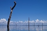
As a cost reducing measure, the trees of the area were not cut before they started to submerge. This caused problems for shipping activity in the lake. In 2002, Brokopondo Watra Wood International N.V. (BWWI) was given permission by Suralco to a start a pilot investigating the possibility to harvest the remaining trees from the lake. The idea came from the late ParamariboParamaribo
Paramaribo is the capital and largest city of Suriname, located on banks of the Suriname River in the Paramaribo District. Paramaribo has a population of roughly 250,000 people, more than half of Suriname's population...
entrepreneur Orlando Lee On, who read about similar harvesting efforts in the Tucuruí Lake
Tucurui dam
The Tucuruí Dam is a concrete gravity dam on the Tocantins River located on the Tucuruí County in the State of Pará, Brazil. The main purpose of the dam is hydroelectric power production and navigation. It is the first large-scale hydroelectric project in the Brazilian Amazon rainforest. The...
in Brazil
Brazil
Brazil , officially the Federative Republic of Brazil , is the largest country in South America. It is the world's fifth largest country, both by geographical area and by population with over 192 million people...
when on a plane to Miami. In 2004 harvesting began, which resulted in the first shipment of wood from the lake to Europe and the United States in June 2005. The Brokopondo lake wood is marketed in Germany as "Stauseeholz" (English: Reservoir wood). In November 2010, Jens Hahne filmed a documentary about the harvesting activities for the Franco-German channel Arte
Arte
Arte is a Franco-German TV network. It is a European culture channel and aims to promote quality programming especially in areas of culture and the arts...
. This documentary was broadcasted on Arte on 22 January 2011.