
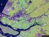
Brielse meer
Encyclopedia
The Brielse Meer is a long, narrow lake between the Dutch
estuary
island
s of Voorne
and Rozenburg
in the province
of Zuid-Holland.
The lake takes its name from Den Briel, a town
on its shore
. It was formerly a Meuse
branch known as Brielse Maas (Den Briel Meuse), which ran from the Botlek
strait near Rotterdam
into the North Sea
. The first stretch, between Botlek and the former confluence
with the Het Scheur branch, was alternatively known as (the last stretch of) Nieuwe Maas
.
When the Brielse Maas silted up in the late nineteenth century, the Nieuwe Waterweg
ship canal
was constructed (1872) and Het Scheur was separated from the Brielse Maas by a dam
. As a precursor to the Delta Works
sea barrier constructions, the Brielse Maas was closed off at both ends in 1950, becoming the Brielse Meer.
Netherlands
The Netherlands is a constituent country of the Kingdom of the Netherlands, located mainly in North-West Europe and with several islands in the Caribbean. Mainland Netherlands borders the North Sea to the north and west, Belgium to the south, and Germany to the east, and shares maritime borders...
estuary
Estuary
An estuary is a partly enclosed coastal body of water with one or more rivers or streams flowing into it, and with a free connection to the open sea....
island
Island
An island or isle is any piece of sub-continental land that is surrounded by water. Very small islands such as emergent land features on atolls can be called islets, cays or keys. An island in a river or lake may be called an eyot , or holm...
s of Voorne
Voorne-Putten
thumb|225px|right|Satellite image of the [[Rhine]]-[[Meuse river|Meuse]] [[river delta|delta]], showing the island of Voorne-Putten Voorne-Putten is an island between the North Sea, the Brielse meer and the rivers Oude Maas, Spui and Haringvliet in the province of South Holland in the Netherlands...
and Rozenburg
Rozenburg (island)
Rozenburg is an island in the western Netherlands, in the province of South Holland. Rozenburg Island was formed centuries ago from several sand bars in the mouth of the river Maas. In 1568 construction started on the first set of dikes and in 1586 the land known as Roosenburgh was leased to Dirk...
in the province
Province
A province is a territorial unit, almost always an administrative division, within a country or state.-Etymology:The English word "province" is attested since about 1330 and derives from the 13th-century Old French "province," which itself comes from the Latin word "provincia," which referred to...
of Zuid-Holland.
The lake takes its name from Den Briel, a town
Town
A town is a human settlement larger than a village but smaller than a city. The size a settlement must be in order to be called a "town" varies considerably in different parts of the world, so that, for example, many American "small towns" seem to British people to be no more than villages, while...
on its shore
Shore
A shore or shoreline is the fringe of land at the edge of a large body of water, such as an ocean, sea, or lake. In Physical Oceanography a shore is the wider fringe that is geologically modified by the action of the body of water past and present, while the beach is at the edge of the shore,...
. It was formerly a Meuse
Meuse River
The Maas or Meuse is a major European river, rising in France and flowing through Belgium and the Netherlands before draining into the North Sea...
branch known as Brielse Maas (Den Briel Meuse), which ran from the Botlek
Botlek
thumb|right|[[Satellite]] [[image]] of the [[Rhine]]-[[Meuse River|Meuse]] [[river delta|delta]] showing the Botlek .The Botlek originally was the name of a stretch of the Nieuwe Maas river, part of the Rhine-Meuse delta near the Dutch cities of Vlaardingen and Spijkenisse in the province of...
strait near Rotterdam
Rotterdam
Rotterdam is the second-largest city in the Netherlands and one of the largest ports in the world. Starting as a dam on the Rotte river, Rotterdam has grown into a major international commercial centre...
into the North Sea
North Sea
In the southwest, beyond the Straits of Dover, the North Sea becomes the English Channel connecting to the Atlantic Ocean. In the east, it connects to the Baltic Sea via the Skagerrak and Kattegat, narrow straits that separate Denmark from Norway and Sweden respectively...
. The first stretch, between Botlek and the former confluence
Confluence (geography)
In geography, a confluence is the meeting of two or more bodies of water. It usually refers to the point where two streams flow together, merging into a single stream...
with the Het Scheur branch, was alternatively known as (the last stretch of) Nieuwe Maas
Nieuwe Maas
The Nieuwe Maas distributary of the Rhine River, and a former distributary of the Maas River, in the Dutch province of South Holland. It runs from the confluence of the rivers Noord and Lek, and flows west through Rotterdam. It ends west of the city where it meets the Oude Maas , near Vlaardingen,...
.
When the Brielse Maas silted up in the late nineteenth century, the Nieuwe Waterweg
Nieuwe Waterweg
The Nieuwe Waterweg is a ship canal in the Netherlands from het Scheur west of the town of Maassluis to the North Sea at Hook of Holland...
ship canal
Ship canal
A ship canal is a canal especially constructed to carry ocean-going ships, as opposed to barges. Ship canals can be enlarged barge canals, canalized or channelized rivers, or canals especially constructed from the start to accommodate ships....
was constructed (1872) and Het Scheur was separated from the Brielse Maas by a dam
Dam
A dam is a barrier that impounds water or underground streams. Dams generally serve the primary purpose of retaining water, while other structures such as floodgates or levees are used to manage or prevent water flow into specific land regions. Hydropower and pumped-storage hydroelectricity are...
. As a precursor to the Delta Works
Delta Works
The Delta Works is a series of construction projects in the southwest of the Netherlands to protect a large area of land around the Rhine-Meuse-Scheldt delta from the sea. The works consist of dams, sluices, locks, dikes, levees, and storm surge barriers...
sea barrier constructions, the Brielse Maas was closed off at both ends in 1950, becoming the Brielse Meer.