
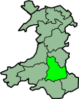
Brecknockshire
Encyclopedia
Brecknockshire also known as the County of Brecknock, Breconshire, or the County of Brecon is one of thirteen historic counties of Wales
, and a former administrative county.
, to the east by Herefordshire
and Monmouthshire
, to the south by Monmouthshire and Glamorgan
, and to the west by Carmarthenshire
and Cardiganshire
. The county is predominantly rural and mountainous. The Black Mountains
occupy the southeast of the area, the Brecon Beacons
the central region, Fforest Fawr
the southwest and Mynydd Epynt
the north. The highest point is Pen y Fan
, 2907 ft (886 m). The River Wye
traces nearly the whole of the northern boundary, and the Usk
flows in an easterly direction through the central valley. The main towns are Brecon
, Builth Wells
, Crickhowell
, Hay-on-Wye
, Llanwrtyd Wells
, Talgarth
and Ystradgynlais
.
. During the Norman period
, the area was classified as a Lordship. The Lord of Brycheiniog was subject to the Mortimer family who ruled most of south and east Wales in an area called the Welsh Marches
. During the reign of Llywelyn ap Gruffydd
of Gwynedd
the homage of the Lord of Brycheiniog was transferred to him from the King of England (Henry III
) by the Treaty of Montgomery
in 1267. However, it was an attack on Brycheiniog by the Marcher Lords Humphrey de Bohun
and Roger Mortimer
in 1276 which led to the final breakdown of the peace between England
and Wales
after which Llywelyn's domain was reduced to just his lands in Gwynedd. Brycheiniog was thereafter subject to the King of England.
created the County of Brecknock by combining a number of "lordships, towns, parishes, commotes and cantreds" in the "Country or Dominion of Wales. The areas combined were:
"Brekenoke" (Brecknock), "Crekehowell" (Crickhowell
) "Tretowre", "Penkelly", "Englisshe Talgarth", "Welsshe Talgarth", "Dynas", "The Haye" (Hay-on-Wye
), "Glynebogh", "Broynlles", "Cantercely", "Llando Blaynllynby", "Estrodewe", "Buelthe" (Builth), and "Llangors". The town of Brecknock or Brecon
was declared the county town.
The county was divided into six hundreds: Builth, Crickhowell, Devynnock, Merthyr, Penkelly, and Talgarth. Brecknock was the only borough
in the county. Other market towns were Builth, Crickhowell and Hay-on-Wye. Under the terms of the 1535 legislation one member of parliament
was returned for the borough and one for the county.
, an elected county council was formed and the area of the county was adjusted, with a number of industrialised areas in the south of the county (Beaufort
, Dukestown, Llechryd and Rassau
) being transferred to Monmouthshire
. The county council was based at the Shire Hall in Brecon.
Under the Public Health Act 1848 and the Local Government Act 1858 a number of towns were created Local Board Districts or Local Government Districts respectively, with local boards
to govern their areas. In 1875 these, along with the Borough of Brecknock, became urban sanitary district
s. At the same time the remainder of the county was divided into rural sanitary districts, some of which crossed county boundaries. The Local Government Act 1894
redesignated these as urban
and rural district
s. Two civil parish
es were administered by rural district councils in neighbouring counties until 1934.
, fifth century founder of Brycheiniog. The shield was quartered. In the first and fourth quarters were the purported arms of Brychan's father Anlach: sable a fess cotised or between two swords in pale argent hilted gold, the upper sword point-upwards, the lower point-downwards. In the second and third quarters were arms representing Brychan's mother, Marchell: or, three reremice (bats) 2 and 1 azure. The motto Undeb Hedd Llywddiant or "Unity, Peace, Prosperity" was used with the arms. The supposed fifth century arms were invented in the Middle Ages
, heraldry having not developed until several centuries later. The county council did not obtain an official grant of armorial bearings, although the unofficial arms subsequently became the basis for those granted to the successor Brecknock Borough Council.
. The bulk of its area passed to the new county of Powys
, where it became the Borough of Brecknock
, one of three districts
of the new county. At the same time the parishes of Penderyn and Vaynor
went instead to the Cynon Valley
and Merthyr Tydfil
districts in Mid Glamorgan
, whilst the urban district of Brynmawr
and the parish of Llanelly
from Crickhowell Rural District became part of Blaenau Gwent
.
In 1996 a further reorganisation of local government took place in Wales
, and Powys became a unitary authority. A "Brecknockshire" area was formed under a decentralisation
scheme, and a "shire committee" consisting of councillors elected for electoral divisions within the former Borough of Brecknock exercises functions delegated by Powys County Council. According to the 2001 census the area covered by the shire committee had a population of 42,075.
Wales
Wales is a country that is part of the United Kingdom and the island of Great Britain, bordered by England to its east and the Atlantic Ocean and Irish Sea to its west. It has a population of three million, and a total area of 20,779 km²...
, and a former administrative county.
Geography
Brecknockshire was bounded to the north by RadnorshireRadnorshire
Radnorshire is one of thirteen historic and former administrative counties of Wales. It is represented by the Radnorshire area of Powys, which according to the 2001 census, had a population of 24,805...
, to the east by Herefordshire
Herefordshire
Herefordshire is a historic and ceremonial county in the West Midlands region of England. For Eurostat purposes it is a NUTS 3 region and is one of three counties that comprise the "Herefordshire, Worcestershire and Gloucestershire" NUTS 2 region. It also forms a unitary district known as the...
and Monmouthshire
Monmouthshire (historic)
Monmouthshire , also known as the County of Monmouth , is one of thirteen ancient counties of Wales and a former administrative county....
, to the south by Monmouthshire and Glamorgan
Glamorgan
Glamorgan or Glamorganshire is one of the thirteen historic counties and a former administrative county of Wales. It was originally an early medieval kingdom of varying boundaries known as Glywysing until taken over by the Normans as a lordship. Glamorgan is latterly represented by the three...
, and to the west by Carmarthenshire
Carmarthenshire
Carmarthenshire is a unitary authority in the south west of Wales and one of thirteen historic counties. It is the 3rd largest in Wales. Its three largest towns are Llanelli, Carmarthen and Ammanford...
and Cardiganshire
Ceredigion
Ceredigion is a county and former kingdom in mid-west Wales. As Cardiganshire , it was created in 1282, and was reconstituted as a county under that name in 1996, reverting to Ceredigion a day later...
. The county is predominantly rural and mountainous. The Black Mountains
Black Mountains, Wales
The Black Mountains are a group of hills spread across parts of Powys and Monmouthshire in southeast Wales, and extending across the national border into Herefordshire, England. They are the easternmost of the four ranges of hills that comprise the Brecon Beacons National Park, and are frequently...
occupy the southeast of the area, the Brecon Beacons
Brecon Beacons
The Brecon Beacons is a mountain range in South Wales. In a narrow sense, the name refers to the range of popular peaks south of Brecon, including South Wales' highest mountain, Pen y Fan, and which together form the central section of the Brecon Beacons National Park...
the central region, Fforest Fawr
Fforest Fawr
Fforest Fawr is the name given to an extensive upland area in the county of Powys, Wales. Formerly known as the 'Great Forest of Brecknock' in English, it was a royal hunting area for several centuries but is now used primarily for sheep grazing, forestry, water catchment and recreation...
the southwest and Mynydd Epynt
Mynydd Epynt
Mynydd Epynt is an upland area of Mid Wales within the county of Powys, Wales. It is bounded to the south by the upper section of the valley of the River Usk, to the north by that of the Afon Irfon and to the east by the valley of the River Wye. Its western boundary is less distinct but lies...
the north. The highest point is Pen y Fan
Pen y Fan
Pen y Fan is the highest peak in South Wales and southern Britain, situated in the Brecon Beacons National Park. At above sea-level, it is also the highest peak in Britain south of the Snowdonia mountain range...
, 2907 ft (886 m). The River Wye
River Wye
The River Wye is the fifth-longest river in the UK and for parts of its length forms part of the border between England and Wales. It is important for nature conservation and recreation.-Description:...
traces nearly the whole of the northern boundary, and the Usk
River Usk
The River Usk rises on the northern slopes of the Black Mountain of mid-Wales, in the easternmost part of the Brecon Beacons National Park. Initially it flows north into Usk Reservoir, then east by Sennybridge to Brecon before turning southeast to flow by Talybont-on-Usk, Crickhowell and...
flows in an easterly direction through the central valley. The main towns are Brecon
Brecon
Brecon is a long-established market town and community in southern Powys, Mid Wales, with a population of 7,901. It was the county town of the historic county of Brecknockshire; although its role as such was eclipsed with the formation of Powys, it remains an important local centre...
, Builth Wells
Builth Wells
Builth Wells is a town in the county of Powys, within the historic boundaries of Brecknockshire, mid Wales, lying at the confluence of the River Wye and the River Irfon, in the Welsh of the Wye Valley. It has a population of 2,352....
, Crickhowell
Crickhowell
Crickhowell is a small town in Powys, Mid Wales.-Location:The name Crickhowell is taken from that of the nearby Iron Age hill fort of Crug Hywel above the town, the Welsh language name being anglicised by map-makers and local English-speaking people...
, Hay-on-Wye
Hay-on-Wye
Hay-on-Wye , often described as "the town of books", is a small market town and community in Powys, Wales.-Location:The town lies on the east bank of the River Wye and is within the Brecon Beacons National Park, just north of the Black Mountains...
, Llanwrtyd Wells
Llanwrtyd Wells
Llanwrtyd Wells is a small town in the parish of Llanwrtyd in Powys, mid Wales, lying on the River Irfon.With a population of 601 people , it claims to be the smallest town in Britain, although Fordwich in Kent has a smaller population...
, Talgarth
Talgarth
Talgarth is a small market town and community in southern Powys , Mid Wales, with a population of 1,645. Notable buildings in the town include its 14th-century parish church and 13th century Pele Tower, located in the town centre, now home to the Tourist Information and Resource Centre...
and Ystradgynlais
Ystradgynlais
Ystradgynlais is a town on the River Tawe in south west Powys; it is the second largest town in Powys, Wales. The town grew around the iron-making, coal-mining and watch-making industries....
.
Kingdom and lordship
The kingdom of Brycheiniog was established in the 5th century and survived until the 10th century when it was subjugated by the Anglo-SaxonsAnglo-Saxons
Anglo-Saxon is a term used by historians to designate the Germanic tribes who invaded and settled the south and east of Great Britain beginning in the early 5th century AD, and the period from their creation of the English nation to the Norman conquest. The Anglo-Saxon Era denotes the period of...
. During the Norman period
Anglo-Norman
The Anglo-Normans were mainly the descendants of the Normans who ruled England following the Norman conquest by William the Conqueror in 1066. A small number of Normans were already settled in England prior to the conquest...
, the area was classified as a Lordship. The Lord of Brycheiniog was subject to the Mortimer family who ruled most of south and east Wales in an area called the Welsh Marches
Welsh Marches
The Welsh Marches is a term which, in modern usage, denotes an imprecisely defined area along and around the border between England and Wales in the United Kingdom. The precise meaning of the term has varied at different periods...
. During the reign of Llywelyn ap Gruffydd
Llywelyn ap Gruffydd
Llywelyn ap Gruffydd may refer to:*Llywelyn the Last *Llywelyn ap Gruffydd Fychan...
of Gwynedd
Kingdom of Gwynedd
Gwynedd was one petty kingdom of several Welsh successor states which emerged in 5th-century post-Roman Britain in the Early Middle Ages, and later evolved into a principality during the High Middle Ages. It was based on the former Brythonic tribal lands of the Ordovices, Gangani, and the...
the homage of the Lord of Brycheiniog was transferred to him from the King of England (Henry III
Henry III of England
Henry III was the son and successor of John as King of England, reigning for 56 years from 1216 until his death. His contemporaries knew him as Henry of Winchester. He was the first child king in England since the reign of Æthelred the Unready...
) by the Treaty of Montgomery
Treaty of Montgomery
By means of the Treaty of Montgomery , Llywelyn ap Gruffydd was acknowledged as Prince of Wales by the English king Henry III, the only time in history that an English ruler would recognise the right of a ruler of Gwynedd over Wales...
in 1267. However, it was an attack on Brycheiniog by the Marcher Lords Humphrey de Bohun
Humphrey de Bohun, 3rd Earl of Hereford
Humphrey de Bohun , 3rd Earl of Hereford and 2nd Earl of Essex, was an English nobleman known primarily for his opposition to King Edward I over the Confirmatio Cartarum. He was also an active participant in the Welsh Wars and maintained for several years a private feud with the earl of Gloucester...
and Roger Mortimer
Roger Mortimer
Roger Mortimer was the name of several Marcher lords:* Roger Mortimer of Wigmore , married Isabel de Ferriers and became Lord of Maelienydd...
in 1276 which led to the final breakdown of the peace between England
England
England is a country that is part of the United Kingdom. It shares land borders with Scotland to the north and Wales to the west; the Irish Sea is to the north west, the Celtic Sea to the south west, with the North Sea to the east and the English Channel to the south separating it from continental...
and Wales
Wales
Wales is a country that is part of the United Kingdom and the island of Great Britain, bordered by England to its east and the Atlantic Ocean and Irish Sea to its west. It has a population of three million, and a total area of 20,779 km²...
after which Llywelyn's domain was reduced to just his lands in Gwynedd. Brycheiniog was thereafter subject to the King of England.
Creation of county
The Laws in Wales Act 1535Laws in Wales Acts 1535-1542
The Laws in Wales Acts 1535 and 1542 were parliamentary measures by which the legal system of Wales was annexed to England and the norms of English administration introduced. The intention was to create a single state and a single legal jurisdiction; frequently referred to as England and Wales...
created the County of Brecknock by combining a number of "lordships, towns, parishes, commotes and cantreds" in the "Country or Dominion of Wales. The areas combined were:
"Brekenoke" (Brecknock), "Crekehowell" (Crickhowell
Crickhowell
Crickhowell is a small town in Powys, Mid Wales.-Location:The name Crickhowell is taken from that of the nearby Iron Age hill fort of Crug Hywel above the town, the Welsh language name being anglicised by map-makers and local English-speaking people...
) "Tretowre", "Penkelly", "Englisshe Talgarth", "Welsshe Talgarth", "Dynas", "The Haye" (Hay-on-Wye
Hay-on-Wye
Hay-on-Wye , often described as "the town of books", is a small market town and community in Powys, Wales.-Location:The town lies on the east bank of the River Wye and is within the Brecon Beacons National Park, just north of the Black Mountains...
), "Glynebogh", "Broynlles", "Cantercely", "Llando Blaynllynby", "Estrodewe", "Buelthe" (Builth), and "Llangors". The town of Brecknock or Brecon
Brecon
Brecon is a long-established market town and community in southern Powys, Mid Wales, with a population of 7,901. It was the county town of the historic county of Brecknockshire; although its role as such was eclipsed with the formation of Powys, it remains an important local centre...
was declared the county town.
The county was divided into six hundreds: Builth, Crickhowell, Devynnock, Merthyr, Penkelly, and Talgarth. Brecknock was the only borough
Borough
A borough is an administrative division in various countries. In principle, the term borough designates a self-governing township although, in practice, official use of the term varies widely....
in the county. Other market towns were Builth, Crickhowell and Hay-on-Wye. Under the terms of the 1535 legislation one member of parliament
Member of Parliament
A Member of Parliament is a representative of the voters to a :parliament. In many countries with bicameral parliaments, the term applies specifically to members of the lower house, as upper houses often have a different title, such as senate, and thus also have different titles for its members,...
was returned for the borough and one for the county.
Governance
Under the Local Government Act 1888Local Government Act 1888
The Local Government Act 1888 was an Act of the Parliament of the United Kingdom, which established county councils and county borough councils in England and Wales...
, an elected county council was formed and the area of the county was adjusted, with a number of industrialised areas in the south of the county (Beaufort
Beaufort, Ebbw Vale
Beaufort is a village located in the historic county of Brecknockshire and the preserved county of Gwent. It currently lies on the northern edge of the county borough of Blaenau Gwent in Wales....
, Dukestown, Llechryd and Rassau
Rassau
Rassau, sometimes The Rassau is a small village located in the historic county of Brecknockshire and the preserved county of Gwent. It currently lies on the northern edge of the county borough of Blaenau Gwent in Wales. According to the 2001 census, the population of Rassau is 3,190...
) being transferred to Monmouthshire
Monmouthshire (historic)
Monmouthshire , also known as the County of Monmouth , is one of thirteen ancient counties of Wales and a former administrative county....
. The county council was based at the Shire Hall in Brecon.
Under the Public Health Act 1848 and the Local Government Act 1858 a number of towns were created Local Board Districts or Local Government Districts respectively, with local boards
Local board of health
Local Boards or Local Boards of Health were local authorities in urban areas of England and Wales from 1848 to 1894. They were formed in response to cholera epidemics and were given powers to control sewers, clean the streets, regulate slaughterhouses and ensure the proper supply of water to their...
to govern their areas. In 1875 these, along with the Borough of Brecknock, became urban sanitary district
Sanitary district
Sanitary districts were established in England and Wales in 1875 and in Ireland in 1878. The districts were of two types, based on existing structures:*Urban sanitary districts in towns with existing local government bodies...
s. At the same time the remainder of the county was divided into rural sanitary districts, some of which crossed county boundaries. The Local Government Act 1894
Local Government Act 1894
The Local Government Act 1894 was an Act of the Parliament of the United Kingdom that reformed local government in England and Wales outside the County of London. The Act followed the reforms carried out at county level under the Local Government Act 1888...
redesignated these as urban
Urban district
In the England, Wales and Ireland, an urban district was a type of local government district that covered an urbanised area. Urban districts had an elected Urban District Council , which shared local government responsibilities with a county council....
and rural district
Rural district
Rural districts were a type of local government area – now superseded – established at the end of the 19th century in England, Wales, and Ireland for the administration of predominantly rural areas at a level lower than that of the administrative counties.-England and Wales:In England...
s. Two civil parish
Civil parish
In England, a civil parish is a territorial designation and, where they are found, the lowest tier of local government below districts and counties...
es were administered by rural district councils in neighbouring counties until 1934.
| Sanitary district 1875 - 1894 | County district 1894 - 1974 |
|---|---|
| Brecknock Brecon Brecon is a long-established market town and community in southern Powys, Mid Wales, with a population of 7,901. It was the county town of the historic county of Brecknockshire; although its role as such was eclipsed with the formation of Powys, it remains an important local centre... municipal borough Municipal borough Municipal boroughs were a type of local government district which existed in England and Wales between 1835 and 1974, in Northern Ireland from 1840 to 1973 and in the Republic of Ireland from 1840 to 2002... |
Brecknock municipal borough |
| Brecknock RSD | Brecknock RD Brecknock Rural District Brecknock was a rural district in the administrative county of Breconshire, Wales, from 1894 - 1974. The district surrounded, but did not include, the town of Brecon, which was a separate municipal borough.... |
| Brynmawr Brynmawr Brynmawr is a market town in Blaenau Gwent, south Wales. The town, sometimes cited as the highest town in Wales, is situated at 1,250 to 1,500 feet above sea level and nestled at the head of the South Wales Valleys... LBD (1851) |
Brynmawr UD |
| Builth RSD | Builth RD |
| 1907: Llanwrtyd Llanwrtyd Llanwrtyd – "Gwrtyd's church" – is a rural parish in Powys, mid-Wales, through which flows the River Irfon.The parish church of St David dates from the 11th century and is surrounded by scattered farms... UD |
|
| Builth LGD (1864) | Builth UD, renamed Builth Wells UD 1898. |
| Crickhowell RSD | Crickhowell RD |
| Hay LGD (1864) | Hay Hay-on-Wye Hay-on-Wye , often described as "the town of books", is a small market town and community in Powys, Wales.-Location:The town lies on the east bank of the River Wye and is within the Brecon Beacons National Park, just north of the Black Mountains... UD |
| Hay RSD | Hay RD |
| Merthyr Tydfil RSD (part) | Vaynor and Penderyn RD |
| Neath RSD | Ystradvellte CP (administered as part of Neath RD, Glamorgan) Transferred to Vaynor and Penderyn RD 1934. |
| Pontardawe RSD (part) | Ystradgynlais RD |
| Rhayader RSD (part) | Llanwrthwl CP (administered as part of Rhayader RD Rhayader Rural District Rhayader was, from 1894 to 1974, a rural district in the administrative county of Radnorshire, Wales.The district was formed by the Local Government Act 1894, based on the existing Rhayader Rural Sanitary District... , Radnorshire Radnorshire Radnorshire is one of thirteen historic and former administrative counties of Wales. It is represented by the Radnorshire area of Powys, which according to the 2001 census, had a population of 24,805... ) Transferred to Builth RD 1934. |
Coat of arms
On establishment in 1889 the Brecknockshire County Council adopted the attributed arms of BrychanBrychan
Brychan Brycheiniog was a legendary 5th-century king of Brycheiniog in South Wales.-Life:Celtic hagiography tells us that Brychan was born in Ireland, the son of a Prince Anlach, son of Coronac, and his wife, Marchel, heiress of the Welsh kingdom of Garthmadrun , which the couple later inherited...
, fifth century founder of Brycheiniog. The shield was quartered. In the first and fourth quarters were the purported arms of Brychan's father Anlach: sable a fess cotised or between two swords in pale argent hilted gold, the upper sword point-upwards, the lower point-downwards. In the second and third quarters were arms representing Brychan's mother, Marchell: or, three reremice (bats) 2 and 1 azure. The motto Undeb Hedd Llywddiant or "Unity, Peace, Prosperity" was used with the arms. The supposed fifth century arms were invented in the Middle Ages
Middle Ages
The Middle Ages is a periodization of European history from the 5th century to the 15th century. The Middle Ages follows the fall of the Western Roman Empire in 476 and precedes the Early Modern Era. It is the middle period of a three-period division of Western history: Classic, Medieval and Modern...
, heraldry having not developed until several centuries later. The county council did not obtain an official grant of armorial bearings, although the unofficial arms subsequently became the basis for those granted to the successor Brecknock Borough Council.
Legacy
The administrative county of Brecknock was abolished in 1974 by the Local Government Act 1972Local Government Act 1972
The Local Government Act 1972 is an Act of Parliament in the United Kingdom that reformed local government in England and Wales on 1 April 1974....
. The bulk of its area passed to the new county of Powys
Powys
Powys is a local-government county and preserved county in Wales.-Geography:Powys covers the historic counties of Montgomeryshire and Radnorshire, most of Brecknockshire , and a small part of Denbighshire — an area of 5,179 km², making it the largest county in Wales by land area.It is...
, where it became the Borough of Brecknock
Brecknock (borough)
The Borough of Brecknock was one of the three local government districts of the county of Powys, Wales from 1974 to 1996. The district comprised the majority of the historic county of Brecknockshire....
, one of three districts
Districts of Wales
In 1974, Wales was re-divided for local government purposes into thirty-seven districts. Districts were the second tier of local government introduced by the Local Government Act 1972, being subdivisions of the eight counties introduced at the same time...
of the new county. At the same time the parishes of Penderyn and Vaynor
Vaynor
Vaynor is a village, parish and community in the Merthyr Tydfil County Borough in Wales, United Kingdom.- Location :...
went instead to the Cynon Valley
Cynon Valley
The Cynon Valley , is a famous former coal mining valley within the South Wales Valleys of Wales. The Cynon Valley lies between the other mining Valley of Rhondda and the iron industrial Valley of the Merthyr Valley. Its main towns are Aberdare located North of the Valley and Mountain Ash located...
and Merthyr Tydfil
Merthyr Tydfil
Merthyr Tydfil is a town in Wales, with a population of about 30,000. Although once the largest town in Wales, it is now ranked as the 15th largest urban area in Wales. It also gives its name to a county borough, which has a population of around 55,000. It is located in the historic county of...
districts in Mid Glamorgan
Mid Glamorgan
Mid Glamorgan is a preserved county of Wales. From 1974 until 1996, it was also an administrative county, with a county council.Mid Glamorgan was formed in 1974 under the Local Government Act 1972...
, whilst the urban district of Brynmawr
Brynmawr
Brynmawr is a market town in Blaenau Gwent, south Wales. The town, sometimes cited as the highest town in Wales, is situated at 1,250 to 1,500 feet above sea level and nestled at the head of the South Wales Valleys...
and the parish of Llanelly
Llanelly
Llanelly is the name of both a village and its respective parish in Monmouthshire principal area, within the historic boundaries of Brecknockshire, south-east Wales.- Situation :...
from Crickhowell Rural District became part of Blaenau Gwent
Blaenau Gwent
Blaenau Gwent is a county borough in South Wales, sharing its name with a parliamentary constituency. It borders the unitary authority areas of Monmouthshire and Torfaen to the east, Caerphilly to the west and Powys to the north. Its main towns are Abertillery, Brynmawr, Ebbw Vale and...
.
In 1996 a further reorganisation of local government took place in Wales
Local Government (Wales) Act 1994
The Local Government Act 1994 is an Act of the Parliament of the United Kingdom which created the current local government structure in Wales of 22 unitary authority areas, referred to as principal areas in the Act, and abolished the previous two-tier structure of counties and districts...
, and Powys became a unitary authority. A "Brecknockshire" area was formed under a decentralisation
Décentralisation
Décentralisation is a french word for both a policy concept in French politics from 1968-1990, and a term employed to describe the results of observations of the evolution of spatial economic and institutional organization of France....
scheme, and a "shire committee" consisting of councillors elected for electoral divisions within the former Borough of Brecknock exercises functions delegated by Powys County Council. According to the 2001 census the area covered by the shire committee had a population of 42,075.
Places of interest
- Brecon BeaconsBrecon BeaconsThe Brecon Beacons is a mountain range in South Wales. In a narrow sense, the name refers to the range of popular peaks south of Brecon, including South Wales' highest mountain, Pen y Fan, and which together form the central section of the Brecon Beacons National Park...
and Brecon Beacons Mountain CentreBrecon Beacons Mountain CentreThe Brecon Beacons Mountain Centre is the popular name for the National Park Visitor Centre managed by the Brecon Beacons National Park Authority. It is also known simply as the Mountain Centre, and also as the Libanus Visitor Centre. It is situated near the village of Libanus some 8km / 5mi...
, Libanus - Brecknock MuseumBrecknock MuseumBrecknock Museum is a museum in Brecon, the historic county town of Brecknockshire or Breconshire in Mid Wales. It is managed by Powys County Council.- Location :...
, BreconBreconBrecon is a long-established market town and community in southern Powys, Mid Wales, with a population of 7,901. It was the county town of the historic county of Brecknockshire; although its role as such was eclipsed with the formation of Powys, it remains an important local centre...
- Dan-yr-Ogof Caves, Glyntawe
- Tretower CastleTretower Castlethumb|320px|right|Tretower CastleTretower castle is a castle in the village of Tretower in the county of Powys, Wales.-History:Tretower was founded as a motte and bailey castle. In the 12th century, a shell-keep was added to the motte. By c.1230 a tall cylindrical keep was added to the inside of...
and Tretower CourtTretower CourtTretower Court is a medieval fortified manor house situated in the village of Tretower, near Crickhowell in modern day Powys, previously within the historical county of Breconshire or Brecknockshire.- Local & national importance :...
- Y Gaer, BreconY Gaer, BreconY Gaer, Brecon is a Roman fort situated near modern day Brecon in Mid Wales, United Kingdom.Y Gaer is located at .- History :...
Roman fort .
Lord Lieutenants and High Sheriffs
- See Lord Lieutenant of BrecknockshireLord Lieutenant of BrecknockshireThis is a list of people who served as Lord Lieutenant of Brecknockshire. After 1723, all Lord Lieutenants were also Custos Rotulorum of Brecknockshire...
- See High Sheriff of BrecknockshireHigh Sheriff of BrecknockshireThis is a list of High Sheriffs of Brecknockshire or Breconshire.The office of High Sheriff of Brecknockshire was established in 1535 since when a High Sheriff was appointed annually by the Queen until 1974 when the office was merged into that of High Sheriff of Powys as part of the creation of...