

Bradley County, Arkansas
Encyclopedia
Bradley County is a county
located in the U.S. state
of Arkansas
. The United States Census Bureau
estimated the population to be 14,683 in 2006. The county seat
is Warren
. Bradley County is Arkansas's 43rd county, formed on December 18, 1840, and named for Captain Hugh Bradley, who fought in the War of 1812
. It is an alcohol prohibition or dry county
.
extends to the Saline River valley along the east and southeast edge of Bradley County. The Ouachita River
runs along the southwest edge of the county.
According to the 2000 census, the county has a total area of 654.38 square miles (1,694.8 km²), of which 650.63 square miles (1,685.1 km²) (or 99.43%) is land and 3.75 square miles (9.7 km²) (or 0.57%) is water.
, there were 18,873 people, 13,103 households and 9,346 families residing in the county. The population density
was 19 per square mile (7/km²). There were 7,002 housing units at an average density of 9 per square mile (4/km²). The racial makeup of the county was 53.36% White
, 39.63% Black
or African American
, 0.24% Native American
, 0.06% Asian
, 0.01% Pacific Islander
, 4.91% from other races
, and 0.75% from two or more races. 4.25% of the population were Hispanic
or Latino
of any race.
There were 6,421 households of which 29.50% had children under the age of 18 living with them, 52.20% were married couples
living together, 14.50% had a female householder with no husband present, and 29.90% were non-families. 27.60% of all households were made up of individuals and 13.90% had someone living alone who was 65 years of age or older. The average household size was 2.45 and the average family size was 2.96.
23.60% of the population were under the age of 18, 9.70% from 18 to 24, 26.50% from 25 to 44, 22.80% from 45 to 64, and 17.50% who were 65 years of age or older. The median age was 38 years. For every 100 females there were 97.70 males. For every 100 females age 18 and over, there were 95.80 males.
The median household income
was $38,936, and the median family income was $47,094. Males had a median income of $32,779 versus $27,167 for females. The per capita income
for the county was $42,346. About 20.60% of families and 26.30% of the population were below the poverty line, including 33.10% of those under age 18 and 20.80% of those age 65 or over.
of various cultures had lived along the rivers of Arkansas for thousands of years and created complex societies. Mississippian culture
peoples built massive earthwork mounds
along the Ouachita River
beginning about 1000 CE
.
tribe that lived in the area as long as 5,000 years ago. These sites include the remains of seasonal fishing camps, ceremonial plazas, temple mounds and large villages containing as many as 200 structures.
valley until the latter 17th century.
Alsace was transformed into a mosaic of Catholic and Protestant territories. Alsace was sold to France within the greater context of the Thirty Years' War
(1618–1648). Beset by enemies and to gain a free hand in Hungary, the Habsburgs sold their Sundgau territory (mostly in Upper Alsace) to France in 1646, which had occupied it, for the sum of 1.2 million Thalers.
These riches were needed because Louis XIV's long reign and wars had nearly bankrupted the French monarchy. The Regency of Louis XV rather than reduce spending, France endorsed the monetary theories of John Law a Scottish financier. In 1716, Law was given a charter for the Banque Royale under which the national debt was assigned to the bank in return for extraordinary privileges. The key to the Banque Royale agreement was that the national debt would be paid from revenues derived from opening the Mississippi Valley. The Bank was tied to other ventures of Law—the Company of the West and the Companies of the Indies. All were known as the Mississippi Company. The Mississippi Company
had a monopoly on trade and mineral wealth. The Company boomed on paper. Law was given the title Duc d'Arkansas. Bernard de la Harpe and his party left New Orleans in 1719 to explore the Red River. In 1721, he explored the Arkansas River. At the Yazoo settlements in Mississippi he was joined by Jean Benjamin who became the scientist for the expedition.
In 1718, there were only 700 people in Louisiana. Eight hundred (800) people landed in Louisiana on one day in 1718, doubling the population.
Prisoners were set free in Paris in September 1719 and later, under the condition that they marry prostitudes and go with them to Louisiana. The newly married couples were chained together and taken to the port of embarkation. After complaints from the Mississippi Company
and the concessioners about this class of French immigrants, in May, 1720, the French government prohibited such deportations. But, there was third shipment in 1721.
The Jesuit Charlevoix went from Canada to Louisiana. His letter said "these 9,000 Germans, who were raised in the Palatinate (Alsace part of France) were in Arkansas.
The Germans left Arkansas en masse. They went to New Orleans and demanded passage to Europe.
The Mississippi Company
gave the Germans rich lands on the right bank of the Mississippi River about 25 miles above New Orleans. The area is now known as 'the German Coast
'."
and named many of bayou
s. These settlers returned south to Pointe Coupee before the Spaniards took possession of Louisiana in the late 1760s. The third wave of European settlers were actually descendants of the second wave, mostly true Louisiana Creole
s born near the Point Coupee and Opelousas
Posts. Additionally, a few Canadians came down the river from the Arkansas Post, and a few native French traders also operated along the river in the 1770s.
Prior to 1782, with the exception of occasional failed colonization schemes, the Europeans ignored the vast Ouachita Valley, which extended from the area around Hot Springs, Arkansas
southward towards the Mississippi River in Louisiana. This changed with the 1779–1782 war between England and Spain. After their defeat at the Battle of Baton Rouge
in 1779, the English yielded control of Natchez to the Spaniards, and this led to several years of fighting as the English settlers resisted Spanish rule over them. After the ultimate English defeat, many settlers fled to the Ouachita Valley region, creating the threat of English/American rebel activity in the Ouachita Valley region. This prompted the Spanish governor, Don Bernardo, the Comte de Galvez, to establish a strong buffer zone
between the independent American states and the Spanish province of Louisiana. In 1781 Galvez created the “Poste d'Ouachita” and named Jean-Baptist Filhiol (also known as Don Juan Filhiol) as the commandant. Filhiol served in this capacity between 1782 and 1804, and through his service helped to keep a firm Spanish grip on activities in the region.
Filhiol, his new wife, and a few others arrived in the Ouachita country in April 1782. He traveled up the river, past present-day Union Parish, to the old trading post called “Ecore a Fabri” (now Camden
). For various reasons, after a few years Filhiol decided not to build his headquarters there and took his group back down river to the "Prairie des Canots".
Many Louisiana Creole people
arrived in Louisiana following the Slave Uprising led by Toussaint Breda (later called L'Overture) in 1791 in Ste. Dominique, later called Haiti.
In 1801, Spanish Governor Don Juan Manuel de Salcedo took over for Governor Marquess of Casa Calvo, and the right to deposit goods from the United States was fully restored. Napoleon Bonaparte returned Louisiana to French control from Spain in 1800, under the Treaty of San Ildefonso
(Louisiana had been a Spanish colony since 1762.) However, the treaty was kept secret, and Louisiana remained under Spanish control until a transfer of power to France on November 30, 1803, just three weeks before the cession to the United States.
James Monroe
and Robert R. Livingston traveled to Paris
to negotiate the purchase in 1802. Their interest was only in the port and its environs; they did not anticipate the much larger transfer of territory that would follow.
The Louisiana Purchase
was the acquisition by the United States of America of 828800 square miles (2,146,582.1 km²) of France
's claim to the territory of Louisiana
in 1803.
County (United States)
In the United States, a county is a geographic subdivision of a state , usually assigned some governmental authority. The term "county" is used in 48 of the 50 states; Louisiana is divided into parishes and Alaska into boroughs. Parishes and boroughs are called "county-equivalents" by the U.S...
located in the U.S. state
U.S. state
A U.S. state is any one of the 50 federated states of the United States of America that share sovereignty with the federal government. Because of this shared sovereignty, an American is a citizen both of the federal entity and of his or her state of domicile. Four states use the official title of...
of Arkansas
Arkansas
Arkansas is a state located in the southern region of the United States. Its name is an Algonquian name of the Quapaw Indians. Arkansas shares borders with six states , and its eastern border is largely defined by the Mississippi River...
. The United States Census Bureau
United States Census Bureau
The United States Census Bureau is the government agency that is responsible for the United States Census. It also gathers other national demographic and economic data...
estimated the population to be 14,683 in 2006. The county seat
County seat
A county seat is an administrative center, or seat of government, for a county or civil parish. The term is primarily used in the United States....
is Warren
Warren, Arkansas
Warren is a city in and the county seat of Bradley County, Arkansas, United States. The United States Census Bureau estimated population in 2006 was 6,219....
. Bradley County is Arkansas's 43rd county, formed on December 18, 1840, and named for Captain Hugh Bradley, who fought in the War of 1812
War of 1812
The War of 1812 was a military conflict fought between the forces of the United States of America and those of the British Empire. The Americans declared war in 1812 for several reasons, including trade restrictions because of Britain's ongoing war with France, impressment of American merchant...
. It is an alcohol prohibition or dry county
Dry county
A dry county is a county in the United States whose government forbids the sale of alcoholic beverages. Some prohibit off-premises sale, some prohibit on-premises sale, and some prohibit both. Hundreds of dry counties exist across the United States, almost all of them in the South...
.
Geography
The Mississippi EmbaymentMississippi embayment
The Mississippi Embayment is a physiographic feature in the south-central United States, part of the Mississippi Alluvial Plain. It is essentially a northward continuation of the fluvial sediments of the Mississippi River Delta to its confluence with the Ohio River at Cairo, Illinois. The embayment...
extends to the Saline River valley along the east and southeast edge of Bradley County. The Ouachita River
Ouachita River
The Ouachita River is a river that runs south and east through the U.S. states of Arkansas and Louisiana, joining the Tensas River to form the Black River near Jonesville, Louisiana.-Course:...
runs along the southwest edge of the county.
According to the 2000 census, the county has a total area of 654.38 square miles (1,694.8 km²), of which 650.63 square miles (1,685.1 km²) (or 99.43%) is land and 3.75 square miles (9.7 km²) (or 0.57%) is water.
Major highways
 U.S. Highway 278
 U.S. Highway 63
 Highway 8
 Highway 160
Adjacent counties
- Cleveland County (north)
- Drew County (east)
- Ashley County (southeast)
- Union County (southwest)
- Calhoun County (west)
Demographics
At the 2006 censusCensus
A census is the procedure of systematically acquiring and recording information about the members of a given population. It is a regularly occurring and official count of a particular population. The term is used mostly in connection with national population and housing censuses; other common...
, there were 18,873 people, 13,103 households and 9,346 families residing in the county. The population density
Population density
Population density is a measurement of population per unit area or unit volume. It is frequently applied to living organisms, and particularly to humans...
was 19 per square mile (7/km²). There were 7,002 housing units at an average density of 9 per square mile (4/km²). The racial makeup of the county was 53.36% White
Race (United States Census)
Race and ethnicity in the United States Census, as defined by the Federal Office of Management and Budget and the United States Census Bureau, are self-identification data items in which residents choose the race or races with which they most closely identify, and indicate whether or not they are...
, 39.63% Black
Race (United States Census)
Race and ethnicity in the United States Census, as defined by the Federal Office of Management and Budget and the United States Census Bureau, are self-identification data items in which residents choose the race or races with which they most closely identify, and indicate whether or not they are...
or African American
Race (United States Census)
Race and ethnicity in the United States Census, as defined by the Federal Office of Management and Budget and the United States Census Bureau, are self-identification data items in which residents choose the race or races with which they most closely identify, and indicate whether or not they are...
, 0.24% Native American
Race (United States Census)
Race and ethnicity in the United States Census, as defined by the Federal Office of Management and Budget and the United States Census Bureau, are self-identification data items in which residents choose the race or races with which they most closely identify, and indicate whether or not they are...
, 0.06% Asian
Race (United States Census)
Race and ethnicity in the United States Census, as defined by the Federal Office of Management and Budget and the United States Census Bureau, are self-identification data items in which residents choose the race or races with which they most closely identify, and indicate whether or not they are...
, 0.01% Pacific Islander
Race (United States Census)
Race and ethnicity in the United States Census, as defined by the Federal Office of Management and Budget and the United States Census Bureau, are self-identification data items in which residents choose the race or races with which they most closely identify, and indicate whether or not they are...
, 4.91% from other races
Race (United States Census)
Race and ethnicity in the United States Census, as defined by the Federal Office of Management and Budget and the United States Census Bureau, are self-identification data items in which residents choose the race or races with which they most closely identify, and indicate whether or not they are...
, and 0.75% from two or more races. 4.25% of the population were Hispanic
Race (United States Census)
Race and ethnicity in the United States Census, as defined by the Federal Office of Management and Budget and the United States Census Bureau, are self-identification data items in which residents choose the race or races with which they most closely identify, and indicate whether or not they are...
or Latino
Race (United States Census)
Race and ethnicity in the United States Census, as defined by the Federal Office of Management and Budget and the United States Census Bureau, are self-identification data items in which residents choose the race or races with which they most closely identify, and indicate whether or not they are...
of any race.
There were 6,421 households of which 29.50% had children under the age of 18 living with them, 52.20% were married couples
Marriage
Marriage is a social union or legal contract between people that creates kinship. It is an institution in which interpersonal relationships, usually intimate and sexual, are acknowledged in a variety of ways, depending on the culture or subculture in which it is found...
living together, 14.50% had a female householder with no husband present, and 29.90% were non-families. 27.60% of all households were made up of individuals and 13.90% had someone living alone who was 65 years of age or older. The average household size was 2.45 and the average family size was 2.96.
23.60% of the population were under the age of 18, 9.70% from 18 to 24, 26.50% from 25 to 44, 22.80% from 45 to 64, and 17.50% who were 65 years of age or older. The median age was 38 years. For every 100 females there were 97.70 males. For every 100 females age 18 and over, there were 95.80 males.
The median household income
Median household income
The median household income is commonly used to generate data about geographic areas and divides households into two equal segments with the first half of households earning less than the median household income and the other half earning more...
was $38,936, and the median family income was $47,094. Males had a median income of $32,779 versus $27,167 for females. The per capita income
Per capita income
Per capita income or income per person is a measure of mean income within an economic aggregate, such as a country or city. It is calculated by taking a measure of all sources of income in the aggregate and dividing it by the total population...
for the county was $42,346. About 20.60% of families and 26.30% of the population were below the poverty line, including 33.10% of those under age 18 and 20.80% of those age 65 or over.
Cities and towns
- BanksBanks, ArkansasBanks is a town in Bradley County, Arkansas, United States. The United States Census Bureau estimated the population to be 118 as of 2005.-Geography:Banks is located at ....
- HermitageHermitage, ArkansasHermitage is a town in Bradley County, Arkansas, United States. The United States Census Bureau estimated the population to be 762 as of 2005.-Geography:Hermitage is located at ....
- WarrenWarren, ArkansasWarren is a city in and the county seat of Bradley County, Arkansas, United States. The United States Census Bureau estimated population in 2006 was 6,219....
Unincorporated communities
- Hilo
- IngallsIngalls, ArkansasIngalls is an unincorporated community in Bradley County, Arkansas, United States, 5 miles south of Hermitage. It is situated at 161 feet above mean sea level. The Fordyce & Princeton Railroad goes through this town. It uses ex-Rock Island tracks....
- JerseyJersey, ArkansasJersey is an unincorporated community in Bradley County, Arkansas, United States. It is situated at 161 feet above mean sea level.-References:...
- JohnsvilleJohnsville, ArkansasJohnsville is an unincorporated community in Bradley County, Arkansas, United States. It is situated at 200 feet above mean sea level. It's a very small town and has a very small population. They used to have 2 stores but now they only have one which is closed on Sunday.-References:...
- Moro BayMoro Bay, ArkansasMoro Bay is an unincorporated community in Bradley County, Arkansas, United States. It stands at an elevation of 89 feet above mean sea level.-External links:*...
- SumpterSumpter, ArkansasSumpter is an unincorporated community in Bradley County, Arkansas, United States. It is situated at 243 feet above mean sea level. It is one of the many small towns in Bradley County that has decayed to nearly nothing since the collapse of the logging industry in the early thirties.-References:...
- VickVick, ArkansasVick is an unincorporated community in Bradley County, Arkansas, United States, near Hermitage. It is situated at 148 feet above mean sea level.-References:...
Townships
- Clay (BanksBanks, ArkansasBanks is a town in Bradley County, Arkansas, United States. The United States Census Bureau estimated the population to be 118 as of 2005.-Geography:Banks is located at ....
) - Eagle
- Marion
- Moro
- Ouachita
- Palestine
- Pennington (WarrenWarren, ArkansasWarren is a city in and the county seat of Bradley County, Arkansas, United States. The United States Census Bureau estimated population in 2006 was 6,219....
) - River
- Sumpter
- Washington (HermitageHermitage, ArkansasHermitage is a town in Bradley County, Arkansas, United States. The United States Census Bureau estimated the population to be 762 as of 2005.-Geography:Hermitage is located at ....
)
Early history
Indigenous peoplesIndigenous peoples
Indigenous peoples are ethnic groups that are defined as indigenous according to one of the various definitions of the term, there is no universally accepted definition but most of which carry connotations of being the "original inhabitants" of a territory....
of various cultures had lived along the rivers of Arkansas for thousands of years and created complex societies. Mississippian culture
Mississippian culture
The Mississippian culture was a mound-building Native American culture that flourished in what is now the Midwestern, Eastern, and Southeastern United States from approximately 800 CE to 1500 CE, varying regionally....
peoples built massive earthwork mounds
Earthworks (archaeology)
In archaeology, earthwork is a general term to describe artificial changes in land level. Earthworks are often known colloquially as 'lumps and bumps'. Earthworks can themselves be archaeological features or they can show features beneath the surface...
along the Ouachita River
Ouachita River
The Ouachita River is a river that runs south and east through the U.S. states of Arkansas and Louisiana, joining the Tensas River to form the Black River near Jonesville, Louisiana.-Course:...
beginning about 1000 CE
Common Era
Common Era ,abbreviated as CE, is an alternative designation for the calendar era originally introduced by Dionysius Exiguus in the 6th century, traditionally identified with Anno Domini .Dates before the year 1 CE are indicated by the usage of BCE, short for Before the Common Era Common Era...
.
Caddo Tribe of Native American
The Felsenthal refuge at the south end of Bradley County contains over 200 native American achaeological sites, primarily from the CaddoCaddo
The Caddo Nation is a confederacy of several Southeastern Native American tribes, who traditionally inhabited much of what is now East Texas, northern Louisiana and portions of southern Arkansas and Oklahoma. Today the Caddo Nation of Oklahoma is a cohesive tribe with its capital at Binger, Oklahoma...
tribe that lived in the area as long as 5,000 years ago. These sites include the remains of seasonal fishing camps, ceremonial plazas, temple mounds and large villages containing as many as 200 structures.
French and Spanish control (1540 - 1803)
After Hernando de Soto's exploration of the Mississippi Valley during the 1540s, there is little evidence of any European activity in the Ouachita RiverOuachita River
The Ouachita River is a river that runs south and east through the U.S. states of Arkansas and Louisiana, joining the Tensas River to form the Black River near Jonesville, Louisiana.-Course:...
valley until the latter 17th century.
Mississippi Company 1716 - 1724
John Law encouraged Germans, particularly Germans of the Alsatian region who had recently fallen under French rule, and the Swiss to emigrate.Alsace was transformed into a mosaic of Catholic and Protestant territories. Alsace was sold to France within the greater context of the Thirty Years' War
Thirty Years' War
The Thirty Years' War was fought primarily in what is now Germany, and at various points involved most countries in Europe. It was one of the most destructive conflicts in European history....
(1618–1648). Beset by enemies and to gain a free hand in Hungary, the Habsburgs sold their Sundgau territory (mostly in Upper Alsace) to France in 1646, which had occupied it, for the sum of 1.2 million Thalers.
These riches were needed because Louis XIV's long reign and wars had nearly bankrupted the French monarchy. The Regency of Louis XV rather than reduce spending, France endorsed the monetary theories of John Law a Scottish financier. In 1716, Law was given a charter for the Banque Royale under which the national debt was assigned to the bank in return for extraordinary privileges. The key to the Banque Royale agreement was that the national debt would be paid from revenues derived from opening the Mississippi Valley. The Bank was tied to other ventures of Law—the Company of the West and the Companies of the Indies. All were known as the Mississippi Company. The Mississippi Company
Mississippi Company
The "Mississippi Company" became the "Company of the West" and expanded as the "Company of the Indies" .-The Banque Royale:...
had a monopoly on trade and mineral wealth. The Company boomed on paper. Law was given the title Duc d'Arkansas. Bernard de la Harpe and his party left New Orleans in 1719 to explore the Red River. In 1721, he explored the Arkansas River. At the Yazoo settlements in Mississippi he was joined by Jean Benjamin who became the scientist for the expedition.
In 1718, there were only 700 people in Louisiana. Eight hundred (800) people landed in Louisiana on one day in 1718, doubling the population.
Prisoners were set free in Paris in September 1719 and later, under the condition that they marry prostitudes and go with them to Louisiana. The newly married couples were chained together and taken to the port of embarkation. After complaints from the Mississippi Company
Mississippi Company
The "Mississippi Company" became the "Company of the West" and expanded as the "Company of the Indies" .-The Banque Royale:...
and the concessioners about this class of French immigrants, in May, 1720, the French government prohibited such deportations. But, there was third shipment in 1721.
The Jesuit Charlevoix went from Canada to Louisiana. His letter said "these 9,000 Germans, who were raised in the Palatinate (Alsace part of France) were in Arkansas.
The Germans left Arkansas en masse. They went to New Orleans and demanded passage to Europe.
The Mississippi Company
Mississippi Company
The "Mississippi Company" became the "Company of the West" and expanded as the "Company of the Indies" .-The Banque Royale:...
gave the Germans rich lands on the right bank of the Mississippi River about 25 miles above New Orleans. The area is now known as 'the German Coast
German Coast
The German Coast was a region of early Louisiana settlement located above New Orleans on the Mississippi River – specifically, from east to west, in St. Charles, St. John the Baptist, and St. James parishes of present-day Acadiana. The four settlements along the coast were Karlstein, Hoffen,...
'."
Estonia
Sweden lost Swedish Livonia, Swedish Estonia and Ingria to Russia almost 100 years later, by the Capitulation of Estonia and Livonia in 1710 and the Treaty of Nystad in 1721. Charles Fred. D'Arensbourg emigrated to Louisiana in 1721 with thirty officiers. They preferred exile to Russification and emigrated to Louisiana.French
European interest in the region then came in three distinct waves. The French hunters, trappers, and traders appeared first and operated along the Ouachita River valley until the Natchez Indian massacre of 1729, which frightened away any developers for a while. Next, in the 1740s and 1750s, French settlers meandered north from the Pointe Coupee Post in south French LouisianaFrench Louisiana
The term French Louisiana refers to two distinct regions:* first, to colonial French Louisiana, comprising the massive, middle section of North America claimed by France; and,...
and named many of bayou
Bayou
A bayou is an American term for a body of water typically found in flat, low-lying areas, and can refer either to an extremely slow-moving stream or river , or to a marshy lake or wetland. The name "bayou" can also refer to creeks that see level changes due to tides and hold brackish water which...
s. These settlers returned south to Pointe Coupee before the Spaniards took possession of Louisiana in the late 1760s. The third wave of European settlers were actually descendants of the second wave, mostly true Louisiana Creole
Creole peoples
The term Creole and its cognates in other languages — such as crioulo, criollo, créole, kriolu, criol, kreyol, kreol, kriulo, kriol, krio, etc. — have been applied to people in different countries and epochs, with rather different meanings...
s born near the Point Coupee and Opelousas
Opelousas, Louisiana
Opelousas is a city in and the parish seat of St. Landry Parish, Louisiana, United States. It lies at the junction of Interstate 49 and U.S. Route 190. The population was 22,860 at the 2000 census. Although the 2006 population estimate was 23,222, a 2004 annexation should put the city's...
Posts. Additionally, a few Canadians came down the river from the Arkansas Post, and a few native French traders also operated along the river in the 1770s.
Prior to 1782, with the exception of occasional failed colonization schemes, the Europeans ignored the vast Ouachita Valley, which extended from the area around Hot Springs, Arkansas
Hot Springs, Arkansas
Hot Springs is the 10th most populous city in the U.S. state of Arkansas, the county seat of Garland County, and the principal city of the Hot Springs Metropolitan Statistical Area encompassing all of Garland County...
southward towards the Mississippi River in Louisiana. This changed with the 1779–1782 war between England and Spain. After their defeat at the Battle of Baton Rouge
Battle of Baton Rouge (1779)
The Battle of Baton Rouge was a brief siege during the American Revolutionary War that was decided on September 21, 1779. Baton Rouge was the second British outpost to fall to Spanish arms during Bernardo de Gálvez's march into British West Florida....
in 1779, the English yielded control of Natchez to the Spaniards, and this led to several years of fighting as the English settlers resisted Spanish rule over them. After the ultimate English defeat, many settlers fled to the Ouachita Valley region, creating the threat of English/American rebel activity in the Ouachita Valley region. This prompted the Spanish governor, Don Bernardo, the Comte de Galvez, to establish a strong buffer zone
Buffer zone
A buffer zone is generally a zonal area that lies between two or more other areas , but depending on the type of buffer zone, the reason for it may be to segregate regions or to conjoin them....
between the independent American states and the Spanish province of Louisiana. In 1781 Galvez created the “Poste d'Ouachita” and named Jean-Baptist Filhiol (also known as Don Juan Filhiol) as the commandant. Filhiol served in this capacity between 1782 and 1804, and through his service helped to keep a firm Spanish grip on activities in the region.
Filhiol, his new wife, and a few others arrived in the Ouachita country in April 1782. He traveled up the river, past present-day Union Parish, to the old trading post called “Ecore a Fabri” (now Camden
Camden, Arkansas
Camden is a city in and the county seat of Ouachita County in the southern part of the U.S. state of Arkansas. Long an area of American Indians villages, the French also made a permanent settlement here because of its advantageous location above the Ouachita River. According to 2007 Census...
). For various reasons, after a few years Filhiol decided not to build his headquarters there and took his group back down river to the "Prairie des Canots".
Many Louisiana Creole people
Louisiana Creole people
Louisiana Creole people refers to those who are descended from the colonial settlers in Louisiana, especially those of French and Spanish descent. The term was first used during colonial times by the settlers to refer to those who were born in the colony, as opposed to those born in the Old World...
arrived in Louisiana following the Slave Uprising led by Toussaint Breda (later called L'Overture) in 1791 in Ste. Dominique, later called Haiti.
In 1801, Spanish Governor Don Juan Manuel de Salcedo took over for Governor Marquess of Casa Calvo, and the right to deposit goods from the United States was fully restored. Napoleon Bonaparte returned Louisiana to French control from Spain in 1800, under the Treaty of San Ildefonso
Third Treaty of San Ildefonso
The Third Treaty of San Ildefonso was a secretly negotiated treaty between France and Spain in which Spain returned the colonial territory of...
(Louisiana had been a Spanish colony since 1762.) However, the treaty was kept secret, and Louisiana remained under Spanish control until a transfer of power to France on November 30, 1803, just three weeks before the cession to the United States.
James Monroe
James Monroe
James Monroe was the fifth President of the United States . Monroe was the last president who was a Founding Father of the United States, and the last president from the Virginia dynasty and the Republican Generation...
and Robert R. Livingston traveled to Paris
Paris
Paris is the capital and largest city in France, situated on the river Seine, in northern France, at the heart of the Île-de-France region...
to negotiate the purchase in 1802. Their interest was only in the port and its environs; they did not anticipate the much larger transfer of territory that would follow.
The Louisiana Purchase
Louisiana Purchase
The Louisiana Purchase was the acquisition by the United States of America of of France's claim to the territory of Louisiana in 1803. The U.S...
was the acquisition by the United States of America of 828800 square miles (2,146,582.1 km²) of France
French First Republic
The French First Republic was founded on 22 September 1792, by the newly established National Convention. The First Republic lasted until the declaration of the First French Empire in 1804 under Napoleon I...
's claim to the territory of Louisiana
Louisiana (New France)
Louisiana or French Louisiana was an administrative district of New France. Under French control from 1682–1763 and 1800–03, the area was named in honor of Louis XIV, by French explorer René-Robert Cavelier, Sieur de la Salle...
in 1803.
French, German, Estonian names of creeks, lakes, river landings and places
- L'Aigles Creek, AigleAigleAigle is the capital of the district of Aigle in the canton of Vaud in Switzerland. The town has a population of 8,100 people.The name of this municipality in French means eagle.-Geography:...
"Eagle Creek", Eagle Lake. - Bogalusa. A place on the Saline River near the Ouachita River (a different place with the same name is Bogalusa, Louisiana).
- CharivariCharivariCharivari is the term for a French folk custom in which the community gave a noisy, discordant mock serenade, also pounding on pots and pans, at the home of newlyweds. The loud, public ritual evolved to a form of social coercion, for instance, to force an as-yet-unmarried couple to wed...
Creek, south of Hilo (a French folk custom in which the community gave a noisy, discordant mock serenade, also pounding on pots and pans, at the home of newlyweds. ) - Felsenthal a Germanic word meaning "hills and valleys" or "rocky valleys."
- MoreauMoreau-People:*Basil Anthony Marie Moreau , French priest*Charles Paul Narcisse Moreau French soldier and mathematician .*Christophe Moreau , French cyclist*Daniel Moreau Barringer , American politician...
Bayou de Moreau (or Moro Creek, Moro Bay) Moreau is a FrenchFranceThe French Republic , The French Republic , The French Republic , (commonly known as France , is a unitary semi-presidential republic in Western Europe with several overseas territories and islands located on other continents and in the Indian, Pacific, and Atlantic oceans. Metropolitan France...
surnameSurnameA surname is a name added to a given name and is part of a personal name. In many cases, a surname is a family name. Many dictionaries define "surname" as a synonym of "family name"...
. - Pereogeethe Lake. Pereo (Latin: Disappearance , death , loss.) Geethe (Estonian: female name)
The Early American Period (1804 - 1838)
During the period 1837–1861, settlers arrived from Mississippi, Alabama, Tennessee, and Georgia. Prior to 1860, to reach the available farmland of northwestern Louisiana and southwestern Arkansas, settlers from the Gulf Coast states most often crossed the Mississippi River at Natchez, then came up the Ouachita River.See also
- National Register of Historic Places listings in Bradley County, ArkansasNational Register of Historic Places listings in Bradley County, ArkansasThis is a list of the National Register of Historic Places listings in Bradley County, Arkansas.This is intended to be a complete list of the properties on the National Register of Historic Places in Bradley County, Arkansas, United States...
- Caddoan Mississippian cultureCaddoan Mississippian cultureThe Caddoan Mississippian culture was a prehistoric Native American culture considered by archaeologists as a variant of the Mississippian culture. The Caddoan Mississippians covered a large territory, including what is now Eastern Oklahoma, Western Arkansas, Northeast Texas, and Northwest Louisiana...
- Ouachita tribeOuachita tribeThe Ouachita are a Native American tribe from northeastern Louisiana along the Ouachita River.-History:The Ouachita were loosely affiliated with the Caddo Confederacy. Their traditional homelands were the lower reaches of the Ouachita River and along the Black River...
- Ouachita RiverOuachita RiverThe Ouachita River is a river that runs south and east through the U.S. states of Arkansas and Louisiana, joining the Tensas River to form the Black River near Jonesville, Louisiana.-Course:...
- Saline RiverSaline River (Ouachita River)The Saline River is a tributary of the Ouachita River in the south central portion of the U.S. state of Arkansas.The Saline River begins in the eastern foothills of the Ouachita Mountains in Saline and Garland counties and is one of the last free-flowing rivers in the Ouachita River Basin...
- Mississippi CompanyMississippi CompanyThe "Mississippi Company" became the "Company of the West" and expanded as the "Company of the Indies" .-The Banque Royale:...
- German CoastGerman CoastThe German Coast was a region of early Louisiana settlement located above New Orleans on the Mississippi River – specifically, from east to west, in St. Charles, St. John the Baptist, and St. James parishes of present-day Acadiana. The four settlements along the coast were Karlstein, Hoffen,...
- LuisianaLouisiana (New Spain)Louisiana was the name of an administrative district of the Viceroyalty of New Spain from 1764 to 1803 that represented territory west of the Mississippi River basin, plus New Orleans...
, 1764–1803 (New Spain) - LouisianeLouisiana (New France)Louisiana or French Louisiana was an administrative district of New France. Under French control from 1682–1763 and 1800–03, the area was named in honor of Louis XIV, by French explorer René-Robert Cavelier, Sieur de la Salle...
, 1682–1764 and 1803 - District of LouisianaDistrict of LouisianaThe District of Louisiana, or Louisiana District, was an official, temporary, United States government designation for the portion of the Louisiana Purchase that had not been organized into the Orleans Territory. It officially existed from March 10, 1804 until July 4, 1805, when it was incorporated...
, 1804–1805 - Territory of Louisiana, 1805–1812
- Territory of Missouri, 1812–1821
- Territory of Arkansas, 1819–1836
External links
- Bradley County Pink Tomato Festival
- Bradley County Chamber of Commerce
- Bradley County Industrial Development Corporation
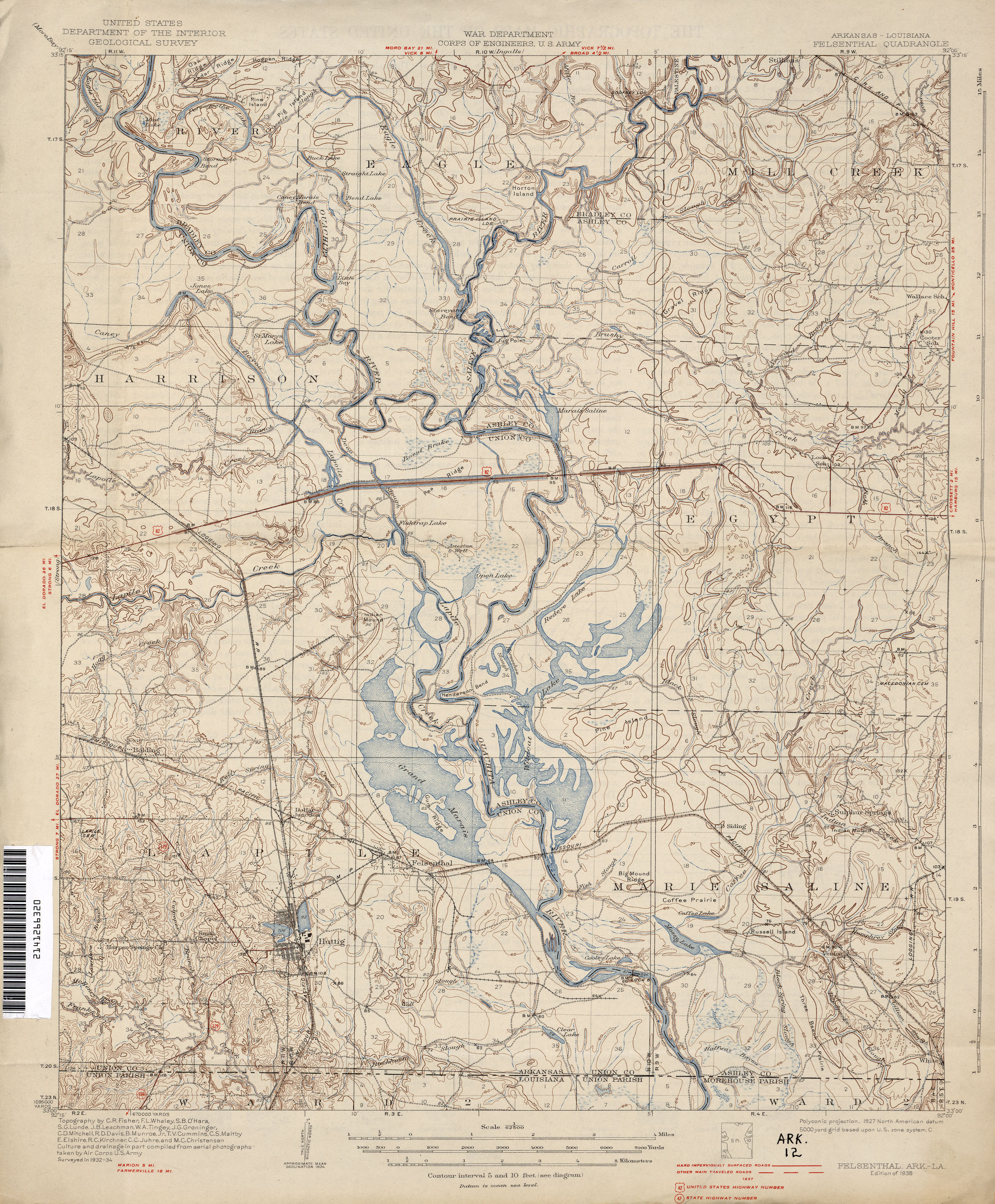
- Felsenthal Historical Topographic Map 1:62,500 1938
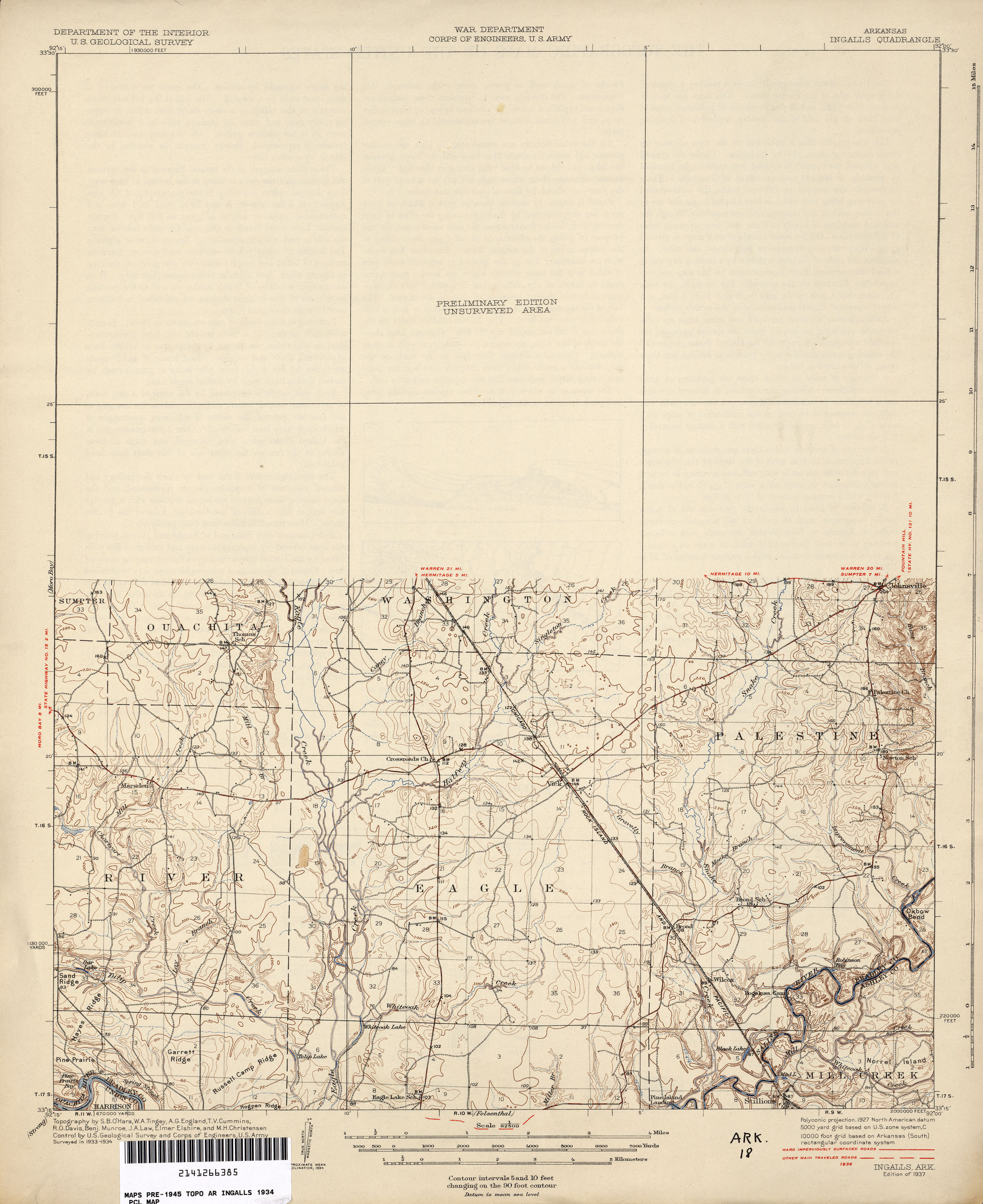
- Ingalls Historical Topographic Map 1:62,500 1936 (1.9MB)
- Ingalls Topographic Map 1986
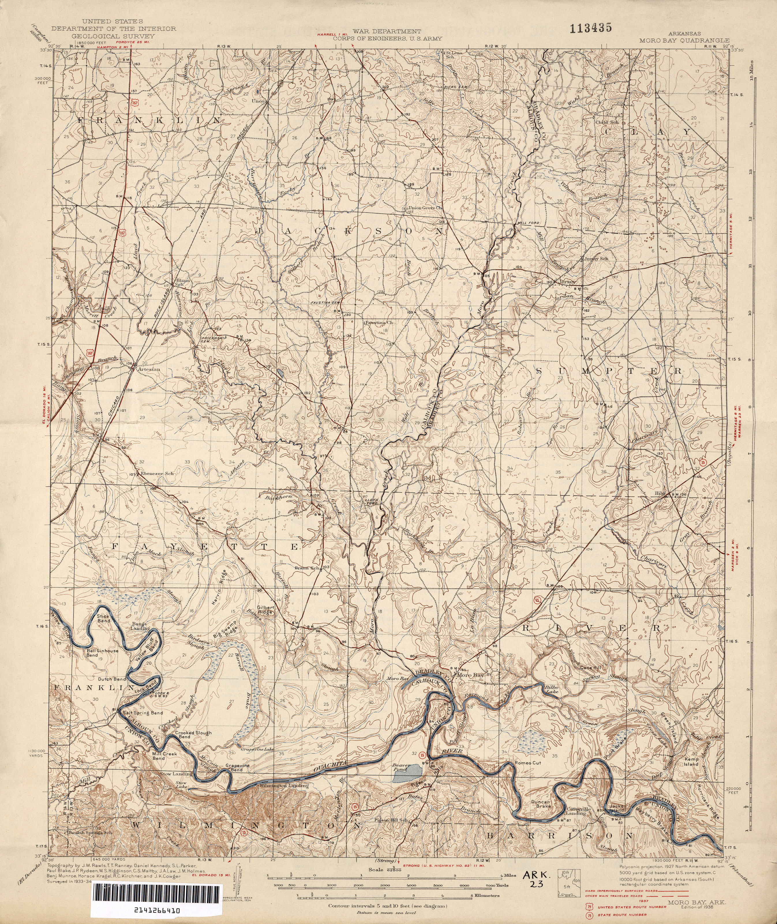
- Moro Bay Historical Topographic Map 1:62,500 1937 (3.0MB)
- Bayou Bartholomew, Saline River, Henri Joutel
- Pre-European Exploration, Prehistory through 1540
- European Exploration and Settlement, 1541 through 1802
- Arkansas Territory 1819, a Journal of Travels
- Arkansas Territory map 1832 by Henry Schenck Tanner