

Boundary Waters-Canadian Derecho
Encyclopedia
Derecho
A derecho is a widespread and long-lived, violent convectively induced straight-line windstorm that is associated with a fast-moving band of severe thunderstorms in the form of a squall line usually taking the form of a bow echo...
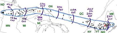
that occurred during the afternoon and evening hours of July 4 and the early morning hours of July 5, 1999. It traveled 1300 miles (2,092 km) and lasted 22 hours.
North Dakota
In the pre-dawn hours of July 4, a band of thunderstorms developed over far eastern North DakotaNorth Dakota
North Dakota is a state located in the Midwestern region of the United States of America, along the Canadian border. The state is bordered by Canada to the north, Minnesota to the east, South Dakota to the south and Montana to the west. North Dakota is the 19th-largest state by area in the U.S....
. Hector International Airport
Hector International Airport
Hector International Airport is a joint civil-military public airport located three miles northwest of the central business district of Fargo, a city in Cass County, North Dakota, United States. It is owned by the City of Fargo Municipal Airport Authority.The airport was named after Martin...
in northwest Fargo
Fargo, North Dakota
Fargo is the largest city in the U.S. state of North Dakota and the county seat of Cass County. In 2010, its population was 105,549, and it had an estimated metropolitan population of 208,777...
recorded winds in excess of 58 mph (95 km/h) for 40 minutes and a maximum wind gust of 91 mi/h. Many planes were damaged or overturned. The hangars suffered damage as well.
The worst damage occurred farther south in West Fargo, North Dakota and in south central Fargo, North Dakota. Wind gusts in these areas were estimated at as high as 110 mi/h.
The storm caused $85 million in damage (1999 dollars) in the Fargo metropolitan area. Over 40,000 people were without power. Cars were overturned, roofs were severely damaged, and power poles were blown down.
Minnesota
Minnesota
Minnesota is a U.S. state located in the Midwestern United States. The twelfth largest state of the U.S., it is the twenty-first most populous, with 5.3 million residents. Minnesota was carved out of the eastern half of the Minnesota Territory and admitted to the Union as the thirty-second state...
and caused massive damage in Cass
Cass County, Minnesota
Cass County is a county located in the U.S. state of Minnesota. As of 2010, the population was 28,567. Its county seat is Walker. A portion of the Leech Lake Indian Reservation is in the county.-Geography:...
, Itasca
Itasca County, Minnesota
Itasca County is a county located in the U.S. state of Minnesota. It is named after Lake Itasca, which is in turn a shortened version the Latin words veritas caput, meaning 'truth' and 'head', a reference to the source of the Mississippi River. As of 2010, the population was 45,058. Its county seat...
, and Aitkin Counties
Aitkin County, Minnesota
Aitkin County is a county located in the U.S. state of Minnesota. As of 2010, the population is 16,202. Its county seat is Aitkin. A portion of the Mille Lacs Indian Reservation is in the county.-History:...
. Damage came out to be around $3 million. A semi-trailer truck was blown over on US highway 53 near Canyon
Canyon, Minnesota
Canyon is an unincorporated community in Northland Township, Saint Louis County, Minnesota, United States.The community is located 27 miles northwest of the city of Duluth at the junction of U.S. Highway 53 and Harris Road ....
.
One person was killed and 60 were injured as the derecho passed through the Boundary Waters Canoe Area
Boundary Waters Canoe Area Wilderness
The Boundary Waters Canoe Area Wilderness , is a wilderness area within the Superior National Forest in northeastern Minnesota under the administration of the U.S. Forest Service...
and Superior National Forest
Superior National Forest
Superior National Forest, part of the United States National Forest system, is located in the Arrowhead Region of the state of Minnesota between the Canada – United States border and the north shore of Lake Superior...
. People were there to enjoy canoeing and other recreation for the Independence Day
Independence Day (United States)
Independence Day, commonly known as the Fourth of July, is a federal holiday in the United States commemorating the adoption of the Declaration of Independence on July 4, 1776, declaring independence from the Kingdom of Great Britain...
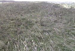
weekend. Straight line winds in excess of 90 mph (145 km/h) uprooted and snapped off trees in over 370,000 acres (1,500 km²) of the 1 million acre (4,000 km²) wilderness area. In total, more than 477,000 acres (1,930 km²) of forest was affected in the Superior National Forest in a swath 30 miles (48.3 km) long and 4 to 12 miles (6.4 to 19.3 km) wide. It's estimated that 25 million trees were blown down in the BWCA.
Ontario
The derecho brought more damage when it crossed the border into northwestern OntarioOntario
Ontario is a province of Canada, located in east-central Canada. It is Canada's most populous province and second largest in total area. It is home to the nation's most populous city, Toronto, and the nation's capital, Ottawa....
during the early afternoon hours of July 4. At its peak near Thunder Bay
Thunder Bay
-In Canada:Thunder Bay is the name of three places in the province of Ontario, Canada along Lake Superior:*Thunder Bay District, Ontario, a district in Northwestern Ontario*Thunder Bay, a city in Thunder Bay District*Thunder Bay, Unorganized, Ontario...
, the winds were estimated to have been much stronger, around 100 mph (160 km/h) and it spawned some small tornadoes. One sailboat was overturned and two people were thrown into the cold waters of Lake Superior
Lake Superior
Lake Superior is the largest of the five traditionally-demarcated Great Lakes of North America. It is bounded to the north by the Canadian province of Ontario and the U.S. state of Minnesota, and to the south by the U.S. states of Wisconsin and Michigan. It is the largest freshwater lake in the...
. They were rescued by a nearby boater.
The storm carved a path of destruction into the sparsely populated forested areas of northern Ontario. The Canadian Pacific track between White River
White River, Ontario
White River is a township located in Ontario, Canada, on the intersection of Highway 17 and Highway 631. It was originally set up as a rail town on the Canadian Pacific Railway in 1885...
and Chapleau
Chapleau, Ontario
Chapleau is a township in Sudbury District, Ontario, Canada. It is home to one of the world's largest wildlife preserves. Chapleau has a population of 2,354 according to the Canada 2006 Census....
in northestern Ontario was put out of service by fallen trees. No major population centers in Ontario east of Lake Superior were affected, however.
Quebec
As it raced eastward at 62 mph (100 km/h), the system entered into western QuebecQuebec
Quebec or is a province in east-central Canada. It is the only Canadian province with a predominantly French-speaking population and the only one whose sole official language is French at the provincial level....
in the Témiscamingue region around 11 pm. A gust of 65 mph (102 km/h) was reported at the automatic station of Angliers. There was also a tremendous amount of lightning associated with this derecho, around 6000 lightning strikes per hour. Another person in this derecho was killed at Val-des-Lacs (V on the map) when a tree fell on the victim. A woman was injured when a tree crushed her car.
After narrowly missing the Ottawa
Ottawa
Ottawa is the capital of Canada, the second largest city in the Province of Ontario, and the fourth largest city in the country. The city is located on the south bank of the Ottawa River in the eastern portion of Southern Ontario...
area, the storm moved quickly into Montreal
Montreal
Montreal is a city in Canada. It is the largest city in the province of Quebec, the second-largest city in Canada and the seventh largest in North America...
(M on the map) around 3 AM heading southeastward toward Maine. Much damage was recorded in the Metropolitan area but the worst affected area of Quebec was farther along its path near Sherbrooke (S on the map) in the Eastern Townships
Eastern Townships
The Eastern Townships is a tourist region and a former administrative region in south-eastern Quebec, lying between the former seigneuries south of the Saint Lawrence River and the United States border. Its northern boundary roughly followed Logan's Line, the geologic boundary between the flat,...
where a church was badly damaged, farm buildings were damaged and 2,000 trees were felled. Hydro-Québec reported that over 600,000 people lost power; some were without power for over a week.
New England
The storm continued southeast and caused more damage in New HampshireNew Hampshire
New Hampshire is a state in the New England region of the northeastern United States of America. The state was named after the southern English county of Hampshire. It is bordered by Massachusetts to the south, Vermont to the west, Maine and the Atlantic Ocean to the east, and the Canadian...
and Vermont
Vermont
Vermont is a state in the New England region of the northeastern United States of America. The state ranks 43rd in land area, , and 45th in total area. Its population according to the 2010 census, 630,337, is the second smallest in the country, larger only than Wyoming. It is the only New England...
, killing one more person, before finally dissipating in Maine
Maine
Maine is a state in the New England region of the northeastern United States, bordered by the Atlantic Ocean to the east and south, New Hampshire to the west, and the Canadian provinces of Quebec to the northwest and New Brunswick to the northeast. Maine is both the northernmost and easternmost...
after 5 am on July, 5th.