

Borrowby, Hambleton
Encyclopedia
Borrowby is a village and civil parish
in the Hambleton
district of North Yorkshire
, England. It is situated halfway between Thirsk
and Northallerton
, about 25 miles (40.2 km) north of York
, in an area called the Vale of Mowbray
, a low-lying agricultural landscape shaped by the last glaciation, that lies between two national parks, the North York Moors
to the east and the Yorkshire Dales
to the west.
Borrowby is one of the so-called Hillside Villages and can be found towards the eastern fringe of the vale where the land begins to rise to the moors. The village is said to be of Danish origin (ending –by) when it was some kind of stronghold. It was then mentioned in the Domesday survey of 1086 and other early records under various spellings of 'Berghby' meaning 'village on a hill'. This exposed location has always been good for growing orchards as the hill tops escaped the glacial debris and cannot be reached by the flood plains of the river, the Cod Beck
. Borrowby was once part of the parish of Leake
, which is further north, and in the first half of the 19th century there was an extensive manufacture of linen
. Since 1978 the village has been a conservation area
.
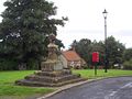 The village grew in a linear form along the main road sloping upwards to the north. It is characteristic, that to the front the buildings are separated by a broad grass verge to the main road and the backs of the properties are associated with the adjoining long plots that are accessed via a back lane. A triangular street formation divides High Borrowby from Low Borrowby and acts as a village green and centre with a pub (the Wheatsheaf Inn), village hall and church. On the village green there is an old cross which is said to have marked some kind of border between Borrowby and the town of Gueldable, at a time when both townships were completely intermixed.
It is clear that the structure and character of the village have not significantly changed to this day, though some original cottages have been replaced by more modern versions and gaps between the buildings have been filled. There used to be a Primitive Methodist
Chapel but today only the Methodist Church remains. On many of the old buildings traces of lime wash that coated the sandstone facades are still visible.
Civil parish
In England, a civil parish is a territorial designation and, where they are found, the lowest tier of local government below districts and counties...
in the Hambleton
Hambleton
Hambleton is a local government district of North Yorkshire, England. The main town and administrative centre is Northallerton, and includes the market towns and major villages of Bedale, Thirsk, Great Ayton, Stokesley and Easingwold....
district of North Yorkshire
North Yorkshire
North Yorkshire is a non-metropolitan or shire county located in the Yorkshire and the Humber region of England, and a ceremonial county primarily in that region but partly in North East England. Created in 1974 by the Local Government Act 1972 it covers an area of , making it the largest...
, England. It is situated halfway between Thirsk
Thirsk
Thirsk is a small market town and civil parish in the Hambleton district of North Yorkshire, England. The local travel links are located a mile from the town centre to Thirsk railway station and to Durham Tees Valley Airport...
and Northallerton
Northallerton
Northallerton is an affluent market town and civil parish in the Hambleton district of North Yorkshire, England. It lies in the Vale of Mowbray and at the northern end of the Vale of York. It has a population of 15,741 according to the 2001 census...
, about 25 miles (40.2 km) north of York
York
York is a walled city, situated at the confluence of the Rivers Ouse and Foss in North Yorkshire, England. The city has a rich heritage and has provided the backdrop to major political events throughout much of its two millennia of existence...
, in an area called the Vale of Mowbray
Vale of Mowbray
The Vale of Mowbray is a stretch of low lying land between the North Yorkshire Moors and the Hambleton Hills to the east and the Yorkshire Dales to the west...
, a low-lying agricultural landscape shaped by the last glaciation, that lies between two national parks, the North York Moors
North York Moors
The North York Moors is a national park in North Yorkshire, England. The moors are one of the largest expanses of heather moorland in the United Kingdom. It covers an area of , and it has a population of about 25,000...
to the east and the Yorkshire Dales
Yorkshire Dales
The Yorkshire Dales is the name given to an upland area in Northern England.The area lies within the historic county boundaries of Yorkshire, though it spans the ceremonial counties of North Yorkshire, West Yorkshire and Cumbria...
to the west.
Borrowby is one of the so-called Hillside Villages and can be found towards the eastern fringe of the vale where the land begins to rise to the moors. The village is said to be of Danish origin (ending –by) when it was some kind of stronghold. It was then mentioned in the Domesday survey of 1086 and other early records under various spellings of 'Berghby' meaning 'village on a hill'. This exposed location has always been good for growing orchards as the hill tops escaped the glacial debris and cannot be reached by the flood plains of the river, the Cod Beck
Cod Beck, North Yorkshire
Cod Beck is a river in North Yorkshire, England. It has a catchment area of .The river extends from above Cod Beck Reservoir at Osmotherley on the edge of the North York Moors through Thirsk and on to join the River Swale at Topcliffe....
. Borrowby was once part of the parish of Leake
Leake, North Yorkshire
Leake is a hamlet and civil parish in the Hambleton district of North Yorkshire, England, about six miles north of Thirsk....
, which is further north, and in the first half of the 19th century there was an extensive manufacture of linen
Linen
Linen is a textile made from the fibers of the flax plant, Linum usitatissimum. Linen is labor-intensive to manufacture, but when it is made into garments, it is valued for its exceptional coolness and freshness in hot weather....
. Since 1978 the village has been a conservation area
Conservation area
A conservation areas is a tract of land that has been awarded protected status in order to ensure that natural features, cultural heritage or biota are safeguarded...
.
It is clear that the structure and character of the village have not significantly changed to this day, though some original cottages have been replaced by more modern versions and gaps between the buildings have been filled. There used to be a Primitive Methodist
Primitive Methodism
Primitive Methodism was a major movement in English Methodism from about 1810 until the Methodist Union in 1932. The Primitive Methodist Church still exists in the United States.-Origins:...
Chapel but today only the Methodist Church remains. On many of the old buildings traces of lime wash that coated the sandstone facades are still visible.