

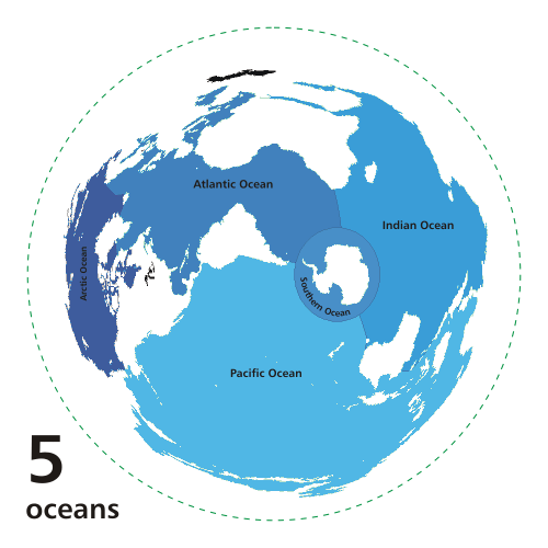
s of the Earth
. The definition, as well as the number of oceans can vary depending on the adopted criteria.
Overview
Though generally described as several 'separate' oceans, these waters comprise one global, interconnected body of salt water sometimes referred to as the World Oceanor global ocean.
.
The major oceanic divisions are defined in part by the continent
s, various archipelago
s, and other criteria. The principal divisions are: Pacific Ocean
, Atlantic Ocean
, Indian Ocean
, Southern or Antarctic Ocean and Arctic Ocean
. Smaller regions of the oceans are called sea
s, gulfs
, bay
s, strait
s and other names.
Geologically, an ocean is an area of oceanic crust
covered by water. Oceanic crust is the thin layer of solidified volcanic basalt
that covers the Earth's mantle
. Continental crust
is thicker but less dense. From this perspective, the earth has three oceans: the World Ocean, the Caspian Sea
, and Black Sea
. The latter two were formed by the collision of Cimmeria
with Laurasia
. The Mediterranean Sea
is at times a discrete ocean, because tectonic plate movement
has repeatedly broken its connection to the World Ocean through the Strait of Gibraltar
. The Black Sea is connected to the Mediterranean through the Bosporus
, but the Bosporus is a natural canal
cut through continental rock some 7,000 years ago, rather than a piece of oceanic sea floor like the Strait of Gibraltar.
Despite their names, smaller landlocked bodies of saltwater that are not connected with the World Ocean, such as the Aral Sea
, are actually salt lake
s.
A complete hierarchy showing which seas belong to which oceans, according to the International Hydrographic Organization
(IHO) and for the whole planet, is available at the European Marine Gazetteer website. See also the Sea
article for lists of seas in each ocean. Also note there are many varying definitions of the world's seas and no single authority.
Arctic Ocean
The Arctic Oceancovers much of the Arctic and washes upon northern North America
and Eurasia
and is sometimes considered a sea
or estuary
of the Atlantic.
The International Hydrographic Organization
(IHO) defines the limits of the Arctic Ocean (excluding the seas it contains) as follows:
Between GreenlandGreenlandGreenland is an autonomous country within the Kingdom of Denmark, located between the Arctic and Atlantic Oceans, east of the Canadian Arctic Archipelago. Though physiographically a part of the continent of North America, Greenland has been politically and culturally associated with Europe for...
and West SpitzbergenSpitsbergenSpitsbergen is the largest and only permanently populated island of the Svalbard archipelago in Norway. Constituting the western-most bulk of the archipelago, it borders the Arctic Ocean, the Norwegian Sea and the Greenland Sea...
— The Northern limit of Greenland SeaGreenland SeaThe Greenland Sea is a body of water that borders Greenland to the west, the Svalbard archipelago to the east, Fram Strait and the Arctic Ocean to the north, and the Norwegian Sea and Iceland to the south. The Greenland Sea is often defined as part of the Arctic Ocean, sometimes as part of the...
.Defined by IHO as "A line joining the Northernmost point of Spitzbergen[ SvalbardSvalbardSvalbard is an archipelago in the Arctic, constituting the northernmost part of Norway. It is located north of mainland Europe, midway between mainland Norway and the North Pole. The group of islands range from 74° to 81° north latitude , and from 10° to 35° east longitude. Spitsbergen is the...] to the Northernmost point of GreenlandGreenlandGreenland is an autonomous country within the Kingdom of Denmark, located between the Arctic and Atlantic Oceans, east of the Canadian Arctic Archipelago. Though physiographically a part of the continent of North America, Greenland has been politically and culturally associated with Europe for...
".
Between West Spitzbergen and North East Land
NordaustlandetNordaustlandet is the second-largest island in the archipelago of Svalbard, Norway, with an area of . It lies north east of Spitsbergen, separated by Hinlopenstretet. Much of Nordaustlandet lies under large ice caps, mainly Austfonna and Vestfonna, the remaining parts of the north being tundra...
— the parallel of lat. 80°N80th parallel northThe 80th parallel north is a circle of latitude that is 80 degrees north of the Earth's equatorial plane, in the Arctic. It crosses the Atlantic Ocean, Europe, Asia, the Arctic Ocean and North America....
.
From Cape Leigh Smith to Cape Kohlsaat
Cape KohlsaatCape Kohlsaat is a point on the eastern shore of Graham Bell Island, the easternmost island of Franz Josef Land, Russia. It is also the easternmost limit of the Franz Josef Archipelago....
— the Northern limit of Barentsz SeaBarents SeaThe Barents Sea is a marginal sea of the Arctic Ocean, located north of Norway and Russia. Known in the Middle Ages as the Murman Sea, the sea takes its current name from the Dutch navigator Willem Barents...
.Defined by IHO as "Cape Leigh Smith across the Islands Bolshoy Ostrov (Great Island)[ Storøya] , Gilles[ KvitøyaKvitøyaKvitøya is an island in the Svalbard archipelago in the Arctic Ocean, with an area of . It is located at , making it the easternmost part of the Kingdom of Norway...] and VictoriaVictoria Island (Russian Arctic)Victoria Island is a small Arctic island situated at 80°9'N 36°46'E, halfway between the Norwegian archipelago of Svalbard and the Russian archipelago of Franz Josef Land. This westernmost of all Russian Arctic islands is about 14 km² and almost completely covered with ice...
; Cape Mary HarmsworthCape Mary HarmsworthCape Mary Harmsworth is a cape located in Alexandra Land .This cape is the westernmost point of the Franz Josef Archipelago proper, not counting far-lying Victoria Island which is geographically detached from the group.Cape Mary Harmsworth was named after Alfred Harmsworth' s wife Mary...
(Southwestern extremity of Alexandra LandAlexandra LandAlexandra Land is a large island located in Franz Josef Land, Russian Federation. Not counting detached and far-lying Victoria Island, it is the westernmost island of the Franz Josef Archipelago.The highest point of the island is...
) along the northern coasts of Franz-Josef LandFranz Josef LandFranz Josef Land, Franz Joseph Land, or Francis Joseph's Land is an archipelago located in the far north of Russia. It is found in the Arctic Ocean north of Novaya Zemlya and east of Svalbard, and is administered by Arkhangelsk Oblast. Franz Josef Land consists of 191 ice-covered islands with a...
as far as Cape Kohlsaat (81°14′N 65°10′E)".
From Cape Kohlsaat
Cape KohlsaatCape Kohlsaat is a point on the eastern shore of Graham Bell Island, the easternmost island of Franz Josef Land, Russia. It is also the easternmost limit of the Franz Josef Archipelago....
to Cape MolotovArctic CapeThe Arctic Cape is the northernmost point of the Komsomolets Island, which in turn is the northernmost island of the Russian Severnaya Zemlya archipelago in the Arctic Ocean. Its coordinates are approximately...
— the Northern limit of Kara SeaKara SeaThe Kara Sea is part of the Arctic Ocean north of Siberia. It is separated from the Barents Sea to the west by the Kara Strait and Novaya Zemlya, and the Laptev Sea to the east by the Severnaya Zemlya....
.Defined by IHO as "Cape Kohlsaat to Cape Molotov (81°16′N 93°43′E) (Northern extremity of Severnaya ZemlyaSevernaya ZemlyaSevernaya Zemlya is an archipelago in the Russian high Arctic at around . It is located off mainland Siberia's Taymyr Peninsula across the Vilkitsky Strait...
on Komsomolets IslandKomsomolets IslandKomsomolets Island is the northernmost island of the Severnaya Zemlya group in the Russian Arctic, and the third largest island in the group. It is the 82nd largest island on earth....
)".
From Cape Molotov to the Northern extremity of Kotelni Island
Kotelny/Faddeyevsky IslandKotelny Island is part of the Anzhu Islands subgroup of the New Siberian Islands located between the Laptev Sea and the East Siberian Sea in the Russian Arctic....
— the Northern limit of Laptev SeaLaptev SeaThe Laptev Sea is a marginal sea of the Arctic Ocean. It is located between the northern coast of Siberia, the Taimyr Peninsula, Severnaya Zemlya and the New Siberian Islands. Its northern boundary passes from the Arctic Cape to a point with co-ordinates of 79°N and 139°E, and ends at the Anisiy...
.Defined by IHO as "A line joining Cape Molotov to the Northern extremity of Kotelni IslandKotelny/Faddeyevsky IslandKotelny Island is part of the Anzhu Islands subgroup of the New Siberian Islands located between the Laptev Sea and the East Siberian Sea in the Russian Arctic....
(76°10′N 138°50′E)".
From the Northern extremity of Kotelni Island to the Northern point of Wrangel Island
Wrangel IslandWrangel Island is an island in the Arctic Ocean, between the Chukchi Sea and East Siberian Sea. Wrangel Island lies astride the 180° meridian. The International Date Line is displaced eastwards at this latitude to avoid the island as well as the Chukchi Peninsula on the Russian mainland...
— the Northern limit of East Siberian SeaEast Siberian SeaThe East Siberian Sea is a marginal sea in the Arctic Ocean. It is located between the Arctic Cape to the north, the coast of Siberia to the south, the New Siberian Islands to the west and Cape Billings, close to Chukotka, and Wrangel Island to the east...
.Defined by IHO as "A line from the Northernmost point of Wrangel Island (179°30'W) to the Northern sides of the De Long IslandsDe Long IslandsThe De Long Islands are an uninhabited archipelago often included as part of the New Siberian Islands, lying north east of Novaya Sibir. This archipelago consists of Jeannette Island, Henrietta Island, Bennett Island, Vilkitsky Island and Zhokhov Island. These five islands have a total area of...
(including HenriettaHenrietta IslandHenrietta Island is the northernmost island of the De Long archipelago in the East Siberian Sea. 40% of the island is covered with glaciers. Henrietta is roughly circular in shape and its diameter is about 6 km...
and Jeannette IslandJeannette IslandJeannette Island is the easternmost island of the De Long Islands archipelago in the East Siberian Sea. It is the second smallest island of the De Long group, being only 2 km in length. It has an area of approximately . The highest peak of the island is...
s) and Bennett IslandBennett IslandBennett Island is the largest of the islands of the De Long group in the northern part of the East Siberian Sea. The area of this island is approximately 150 km² ...
, thence to the Northern extremity of Kotelni Island".
From the Northern point of Wrangel Island to Point Barrow
Point BarrowPoint Barrow or Nuvuk is a headland on the Arctic coast in the U.S. state of Alaska, northeast of Barrow. It is the northernmost point of all the territory of the United States, at...
— the Northern limit of Chuckchi SeaChukchi SeaChukchi Sea is a marginal sea of the Arctic Ocean. It is bounded on the west by the De Long Strait, off Wrangel Island, and in the east by Point Barrow, Alaska, beyond which lies the Beaufort Sea. The Bering Strait forms its southernmost limit and connects it to the Bering Sea and the Pacific...
.Defined by IHO as "A line from Point Barrow, AlaskaAlaskaAlaska is the largest state in the United States by area. It is situated in the northwest extremity of the North American continent, with Canada to the east, the Arctic Ocean to the north, and the Pacific Ocean to the west and south, with Russia further west across the Bering Strait...
(71°20′N 156°20′W) to the Northernmost point of Wrangel Island (179°30'W)".
From Point Barrow to Cape Land's End on Prince Patrick Island
Prince Patrick IslandA member of the Canadian Arctic Archipelago, Prince Patrick Island is the westernmost of the Queen Elizabeth Islands in the Northwest Territories of Canada. The area of the island is , making it the 55th largest island in the world and Canada's 14th largest island...
— the Northern limit of Beaufort SeaBeaufort SeaThe Beaufort Sea is a marginal sea of the Arctic Ocean, located north of the Northwest Territories, the Yukon, and Alaska, west of Canada's Arctic islands. The sea is named after hydrographer Sir Francis Beaufort...
,Defined by IHO as "A line from Point Barrow, Alaska, to Lands End, Prince Patrick Island (76°16′N 124°08′W)". through the Northwest coast of Prince Patrick Island to Cape Leopold M'Clintock, thence to Cape Murray (Brook IslandBrook IslandBrook Island is one of the many uninhabited Canadian Arctic islands in the Qikiqtaaluk Region, Nunavut. It is a Baffin Island offshore island located in Frobisher Bay, southeast of the capital city of Iqaluit. Other islands in the immediate vicinity include Brigus Island, Falk Island, Gay Island,...
) and along the Northwest coast to the extreme Northerly point; to Cape Mackay (Borden IslandBorden IslandBorden Island is an uninhabited, low-lying island in the Queen Elizabeth Islands of northern Canada. With an area of in size, it is the 172nd largest island in the world, and Canada's 30th largest island...
); through the Northwesterly coast of Borden Island to Cape Malloch, to Cape Isachsen (Ellef Ringnes IslandEllef Ringnes IslandEllef Ringnes Island is one of the Sverdrup Islands in Qikiqtaaluk Region, Nunavut, Canada. Also a member of the Queen Elizabeth Islands and Canadian Arctic Archipelago, it is located in the Arctic Ocean, east of Borden Island, and west of Amund Ringnes Island...
); to the Northwest point of Meighen IslandMeighen IslandMeighen Island is an uninhabited member of the Queen Elizabeth Islands, part of the Canadian Arctic Archipelago, in the Qikiqtaaluk Region of Nunavut, Canada. Located at 79°55'N 99°30'W, it measures in size and is topped with an ice cap. The island is continuously icebound, and its northwestern...
to Cape StallworthyCape StallworthyCape Stallworthy is a peninsula in Qikiqtaaluk Region, Nunavut, Canada. It is located at the northern point of Axel Heiberg Island. Frederick Cook began his 1908 North Pole journey from the cape. The cape is sometimes confused with Cape Thomas Hubbard on the opposite side of Eetookashoo Bay...
(Axel Heiberg IslandAxel Heiberg IslandAxel Heiberg Island is an island in the Qikiqtaaluk Region, Nunavut, Canada. Located in the Arctic Ocean, it is the 31st largest island in the world and Canada's seventh largest island. According to Statistics Canada, it has an area of ....
) to Cape Colgate the extreme West point of Ellesmere IslandEllesmere IslandEllesmere Island is part of the Qikiqtaaluk Region of the Canadian territory of Nunavut. Lying within the Canadian Arctic Archipelago, it is considered part of the Queen Elizabeth Islands, with Cape Columbia being the most northerly point of land in Canada...
; through the North shore of Ellesmere Island to Cape ColumbiaCape ColumbiaCape Columbia is the northernmost point of land of Canada, located on Ellesmere Island in the Qikiqtaaluk Region of Nunavut. It marks the westernmost coastal point of Lincoln Sea in the Arctic Ocean...
thence a line to Cape Morris JesupCape Morris JesupCape Morris Jesup is the northernmost point of mainland Greenland at and is 711.8 km from the geographic North Pole...
(GreenlandGreenlandGreenland is an autonomous country within the Kingdom of Denmark, located between the Arctic and Atlantic Oceans, east of the Canadian Arctic Archipelago. Though physiographically a part of the continent of North America, Greenland has been politically and culturally associated with Europe for...
).
Note that these definitions exclude any marginal waterbodies that are separately defined by the IHO (such as the Kara Sea
and East Siberian Sea
), though these are usually considered to be part of the Arctic Ocean.
The CIA defines the limits of the Arctic Ocean
slightly differently, as depicted in the image to the right.
Atlantic Ocean
The Atlantic Oceanseparates the Americas from Eurasia
and Africa
. It may be further subdivided by the equator
into northern and southern portions.
North Atlantic
The 3rd edition of the International Hydrographic Organization's (IHO) Limits of Oceans and Seas defines the limits of the North Atlantic Ocean (excluding the seas it contains) as follows:
On the West. The Eastern limits of the Caribbean SeaCaribbean SeaThe Caribbean Sea is a sea of the Atlantic Ocean located in the tropics of the Western hemisphere. It is bounded by Mexico and Central America to the west and southwest, to the north by the Greater Antilles, and to the east by the Lesser Antilles....
,Defined by IHO as "From Point San Diego (Puerto RicoPuerto RicoPuerto Rico , officially the Commonwealth of Puerto Rico , is an unincorporated territory of the United States, located in the northeastern Caribbean, east of the Dominican Republic and west of both the United States Virgin Islands and the British Virgin Islands.Puerto Rico comprises an...
) Northward along the meridian thereof (65°39'W) to the 100 fathom line, thence Eastward and Southward, in such a manner that all islands, shoals and narrow waters of the Lesser AntillesLesser AntillesThe Lesser Antilles are a long, partly volcanic island arc in the Western Hemisphere. Most of its islands form the eastern boundary of the Caribbean Sea with the Atlantic Ocean, with the remainder located in the southern Caribbean just north of South America...
are included in the Caribbean Sea as far as Galera PointGalera PointGalera Point is the eastern most point in Trinidad, in the island's far northeast. It is in the county of St David and is very close to the town of Toco....
(Northeast extremity of the island of TrinidadTrinidadTrinidad is the larger and more populous of the two major islands and numerous landforms which make up the island nation of Trinidad and Tobago. It is the southernmost island in the Caribbean and lies just off the northeastern coast of Venezuela. With an area of it is also the fifth largest in...
). From Galera Point through Trinidad to Galeota Point (Southeast extreme) and thence to Baja Point (9°32′N 61°0′W) in VenezuelaVenezuelaVenezuela , officially called the Bolivarian Republic of Venezuela , is a tropical country on the northern coast of South America. It borders Colombia to the west, Guyana to the east, and Brazil to the south...
". the Southeastern limits of the Gulf of MexicoGulf of MexicoThe Gulf of Mexico is a partially landlocked ocean basin largely surrounded by the North American continent and the island of Cuba. It is bounded on the northeast, north and northwest by the Gulf Coast of the United States, on the southwest and south by Mexico, and on the southeast by Cuba. In...
Defined by IHO as "A line joining Cape Catoche Light (21°37′N 87°04′W) with the Light on Cape San AntonioCape San Antonio, CubaCape San Antonio, , is a cape which forms the western extremity of Cuba. It extends into the Yucatán Channel.-References:*Merriam-Webster's Geographical Dictionary, Third Edition. Springfield, Massachusetts: Merriam-Webster, Incorporated, 1997....
in CubaCubaThe Republic of Cuba is an island nation in the Caribbean. The nation of Cuba consists of the main island of Cuba, the Isla de la Juventud, and several archipelagos. Havana is the largest city in Cuba and the country's capital. Santiago de Cuba is the second largest city...
, through this island to the meridian of 83°W83rd meridian westThe meridian 83° west of Greenwich is a line of longitude that extends from the North Pole across the Arctic Ocean, North America, the Gulf of Mexico, the Caribbean Sea, Central America, the Pacific Ocean, the Southern Ocean, and Antarctica to the South Pole....
and to the Northward along this meridian to the latitude of the South point of the Dry TortugasDry TortugasThe Dry Tortugas are a small group of islands, located at the end of the Florida Keys, USA, about west of Key West, and west of the Marquesas Keys, the closest islands. Still further west is the Tortugas Bank, which is completely submerged. The first Europeans to discover the islands were the...
(24°35'N), along this parallel Eastward to Rebecca ShoalRebecca Shoal LightThe Rebecca Shoal Light was located on a treacherous coral bank, Rebecca Shoal, 10 km west of the Marquesas Keys and 50 km east of the Dry Tortugas. The bank has a least depth of 3.4 meters and is subject to strong currents and rough seas....
(82°35'W) thence through the shoals and Florida KeysFlorida KeysThe Florida Keys are a coral archipelago in southeast United States. They begin at the southeastern tip of the Florida peninsula, about south of Miami, and extend in a gentle arc south-southwest and then westward to Key West, the westernmost of the inhabited islands, and on to the uninhabited Dry...
to the mainland at eastern end of Florida BayFlorida BayFlorida Bay is the bay located between the southern end of the Florida mainland and the Florida Keys. Its area is variously stated to be , or , or . Nearly all of Florida Bay is included in Everglades National Park. The southern edge, along the Florida Keys is in the Florida Keys National Marine...
, all the narrow waters between the Dry Tortugas and the mainland being considered to be within the Gulf". from the North coast of CubaCubaThe Republic of Cuba is an island nation in the Caribbean. The nation of Cuba consists of the main island of Cuba, the Isla de la Juventud, and several archipelagos. Havana is the largest city in Cuba and the country's capital. Santiago de Cuba is the second largest city...
to Key WestKey WestKey West is an island in the Straits of Florida on the North American continent at the southernmost tip of the Florida Keys. Key West is home to the southernmost point in the Continental United States; the island is about from Cuba....
, the Southwestern limit of the Bay of FundyBay of FundyThe Bay of Fundy is a bay on the Atlantic coast of North America, on the northeast end of the Gulf of Maine between the Canadian provinces of New Brunswick and Nova Scotia, with a small portion touching the U.S. state of Maine...
Defined by IHO as "A line running northwesterly from Cape St. MaryCape St. Marys, Nova ScotiaCape St. Marys is a headland located at the western tip of the Nova Scotia peninsula in the Canadian province of Nova Scotia.Cape St. Marys is not the westernmost point in the province as the two islands comprising the Digby Neck, Long Island and Brier Island, lie further west.-References:*...
(44°05'N) Nova ScotiaNova ScotiaNova Scotia is one of Canada's three Maritime provinces and is the most populous province in Atlantic Canada. The name of the province is Latin for "New Scotland," but "Nova Scotia" is the recognized, English-language name of the province. The provincial capital is Halifax. Nova Scotia is the...
, through Machias Seal IslandMachias Seal IslandMachias Seal Island is an island located in the Gulf of Maine, approximately southeast from Cutler, Maine, and approximately southwest of Southwest Head, New Brunswick on Grand Manan Island. Machias Seal Island is located at and measures approximately in area. It is a neighbour to North Rock....
(67°06'W) and on to Little River Head (44°39'N) in the State of MaineMaineMaine is a state in the New England region of the northeastern United States, bordered by the Atlantic Ocean to the east and south, New Hampshire to the west, and the Canadian provinces of Quebec to the northwest and New Brunswick to the northeast. Maine is both the northernmost and easternmost...
". and the Southeastern and Northeastern limits of the Gulf of St. LawrenceGulf of Saint LawrenceThe Gulf of Saint Lawrence , the world's largest estuary, is the outlet of North America's Great Lakes via the Saint Lawrence River into the Atlantic Ocean...
.Defined by IHO as "A line from Cape CansoCape CansoThis article is about the headland. For the town, see Canso, Nova Scotia.Cape Canso is a headland located at the eastern extremity of the Nova Scotia peninsula in the Canadian province of Nova Scotia....
(45°20′N 61°0′W) to Red PointRed Point (Nova Scotia)Red Point is a headland located at the southwestern extremity of Cape Breton Island in the Canadian province of Nova Scotia....
(45°35′N 60°45′W) in Cape Breton IslandCape Breton IslandCape Breton Island is an island on the Atlantic coast of North America. It likely corresponds to the word Breton, the French demonym for Brittany....
, through this Island to Cape BretonCape Breton (Nova Scotia)This article is about the headland. For other uses, see Cape Breton .This article is about the headland. For other uses, see Cape Breton .This article is about the headland...
and on to Pointe Blanche (46°45′N 56°11′W) in the Island of St. Pierre, and thence to the Southwest point of Morgan Island (46°51′N 55°49′W)" and "A line running from Cape BauldCape BauldCape Bauld is a headland located at the northeasternmost point of Great Northern Peninsula on the island of Newfoundland in the Canadian province of Newfoundland and Labrador....
(North point of Kirpon IslandQuirpon IslandQuirpon Island is a small Canadian island off the northeastern tip of Newfoundland's Great Northern Peninsula in the province of Newfoundland and Labrador....
, 51°40′N 55°25′W) to the East extreme of Belle IsleBelle Isle (Newfoundland and Labrador)Belle Isle is an uninhabited island just off the coast of Labrador and north of Newfoundland at the Atlantic entrance to the Strait of Belle Isle which takes its name...
and on to the Northeast Ledge (52°02′N 55°15′W). Thence a line joining this ledge with the East extreme of Cape St. CharlesCape St. CharlesCape St. Charles is a headland on the coast of Labrador in the Canadian province of Newfoundland and Labrador. At longitude 55°37'15"W it is the most easterly point on the continental North America....
(52°13'N) in LabradorLabradorLabrador is the distinct, northerly region of the Canadian province of Newfoundland and Labrador. It comprises the mainland portion of the province, separated from the island of Newfoundland by the Strait of Belle Isle...
".
On the North. The Southern limit of Davis Strait
Davis StraitDavis Strait is a northern arm of the Labrador Sea. It lies between mid-western Greenland and Nunavut, Canada's Baffin Island. The strait was named for the English explorer John Davis , who explored the area while seeking a Northwest Passage....
Defined by IHO as "The parallel of 60° North60th parallel northThe 60th parallel north is a circle of latitude that is 60 degrees north of the Earth's equatorial plane. It crosses Europe, Asia, the Pacific Ocean, North America, and the Atlantic Ocean....
between Greenland and LabradorLabradorLabrador is the distinct, northerly region of the Canadian province of Newfoundland and Labrador. It comprises the mainland portion of the province, separated from the island of Newfoundland by the Strait of Belle Isle...
". from the coast of LabradorLabradorLabrador is the distinct, northerly region of the Canadian province of Newfoundland and Labrador. It comprises the mainland portion of the province, separated from the island of Newfoundland by the Strait of Belle Isle...
to GreenlandGreenlandGreenland is an autonomous country within the Kingdom of Denmark, located between the Arctic and Atlantic Oceans, east of the Canadian Arctic Archipelago. Though physiographically a part of the continent of North America, Greenland has been politically and culturally associated with Europe for...
and the Southwestern limit of the Greenland SeaGreenland SeaThe Greenland Sea is a body of water that borders Greenland to the west, the Svalbard archipelago to the east, Fram Strait and the Arctic Ocean to the north, and the Norwegian Sea and Iceland to the south. The Greenland Sea is often defined as part of the Arctic Ocean, sometimes as part of the...
Defined by IHO as "A line joining Straumness (NW extreme of Iceland) to Cape Nansen (68°15′N 29°30′W) in Greenland". and Norwegian SeaNorwegian SeaThe Norwegian Sea is a marginal sea in the North Atlantic Ocean, northwest of Norway. It is located between the North Sea and the Greenland Sea and adjoins the North Atlantic Ocean to the west and the Barents Sea to the northeast. In the southwest, it is separated from the Atlantic Ocean by a...
Defined by IHO as "From a point on the West coast of Norway in Latitude 61°00' North61st parallel northThe 61st parallel north is a circle of latitude that is 61 degrees north of the Earth's equatorial plane. It crosses the Atlantic Ocean, Europe, Asia and North America....
along this parallel to Longitude 0°53' West thence a line to the NE extreme of FuglöFugloyFugloy is the eastern-most island in the Faroe Islands. The name means bird island, and refers to the large number of birds that nest on the island's cliffs.- Geography :...
(62°21′N 6°15′W) and on to the East extreme of Gerpir (65°05′N 13°30′W) in IcelandIcelandIceland , described as the Republic of Iceland, is a Nordic and European island country in the North Atlantic Ocean, on the Mid-Atlantic Ridge. Iceland also refers to the main island of the country, which contains almost all the population and almost all the land area. The country has a population...
". from Greenland to the Shetland Islands.
On the East. The Northwestern limit of the North Sea
North SeaIn the southwest, beyond the Straits of Dover, the North Sea becomes the English Channel connecting to the Atlantic Ocean. In the east, it connects to the Baltic Sea via the Skagerrak and Kattegat, narrow straits that separate Denmark from Norway and Sweden respectively...
,Defined by IHO as "From Dunnet HeadDunnet HeadDunnet Head is a peninsula in Caithness, on the north coast of Scotland, that includes the most northerly point of the mainland of Great Britain. The point, known as Easter Head, is at , about westnorthwest of John o' Groats and about from Duncansby Head...
(3°22'W) in ScotlandScotlandScotland is a country that is part of the United Kingdom. Occupying the northern third of the island of Great Britain, it shares a border with England to the south and is bounded by the North Sea to the east, the Atlantic Ocean to the north and west, and the North Channel and Irish Sea to the...
to Tor Ness (58°47'N) in the Island of HoyHoyHoy is an island in Orkney, Scotland. With an area of it is the second largest in the archipelago after the Mainland. It is connected by a causeway called The Ayre to South Walls...
, thence through this island to the Kame of Hoy (58°55'N) on to Breck Ness on Mainland (58°58'N) through this island to Costa HeadCosta HeadCosta Head is a prominent headland on Eynhallow Sound on the northwestern coast of the Orkney Mainland, Scotland. The tidal indraught of Eynhallow Sound is "scarcely felt beyond a line joining Costa Head and the Reef of Quendale". To the east is the Point of Hellia on which is located the Broch...
(3°14'W) and to Inga Ness (59'17'N) in WestrayWestrayWestray is one of the Orkney Islands in Scotland, with a population of around 550 people. Its main village is Pierowall, with a heritage centre, the ruined Lady Kirk and ferries to Papa Westray.-Geography and geology:...
through Westray, to Bow Head, across to Mull Head (North point of Papa WestrayPapa WestrayPapa Westray, also known as Papay, is one of the Orkney Islands in Scotland, with a population of 65 at the time of the 2001 Census, now increased to 70 people...
) and on to Seal Skerry (North point of North RonaldsayNorth RonaldsayNorth Ronaldsay is the northernmost of the Orkney Islands, Scotland and with an area of is the fourteenth largest.-Geography:North Ronaldsay lies around north of its nearest neighbour, Sanday at . The island is around long along its length and is defined by two large sandy bays; Linklet Bay on...
) and thence to Horse IslandHorse HolmThe Horse Holm , referred to on maps as Horse Island, known to locals simply as Da Holm, and used as an alignment point by local fishermen for several fishing marks, lies about 2.3 km west of Sumburgh Head at the south tip of the Mainland, Shetland.-Footnotes:This article incorporates text from ...
(South point of the Shetland Islands)". the Northern and Western limits of the Scottish SeasInner Seas off the West Coast of ScotlandThe Inner Seas off the West Coast of Scotland is a marine area designated by the International Hydrographic Organization . It consists of a number of waterbodies between the Scottish mainland, the Outer Hebrides islands, and the coast of Northern Ireland....
,Defined by IHO as "A line running from Bloody ForelandGweedoreGweedore is an Irish-speaking district located on the Atlantic coast of County Donegal, part of the Province of Ulster in Ireland. Gweedore stretches some 16 miles from Meenaclady in the north to Crolly in the south and around 9 miles from Dunlewey in the east to Magheraclogher in the west, and...
(55°10′N 8°17′W) in Ireland to the West point of Tory IslandTory IslandToraigh is an inhabited island 14.5 km off the northwest coast of County Donegal, Ireland. It is also known in Irish as Oileán Thoraigh, Oileán Thoraí or Oileán Thúr Rí.-Language:The main spoken language on the island is Irish, but English is also understood...
, on to Barra HeadBarra HeadBarra Head, also known as Berneray , is the southernmost of the Outer Hebrides in Scotland. Within the Outer Hebrides, it forms part of the Barra Isles archipelago. Originally, Barra Head only referred to the southernmost headland of Berneray but is now a common name for the entire island...
, the Southwest point of the HebridesHebridesThe Hebrides comprise a widespread and diverse archipelago off the west coast of Scotland. There are two main groups: the Inner and Outer Hebrides. These islands have a long history of occupation dating back to the Mesolithic and the culture of the residents has been affected by the successive...
, thence through these islands, in such a manner that the West coasts of the main islands appertain to the Atlantic OceanAtlantic OceanThe Atlantic Ocean is the second-largest of the world's oceanic divisions. With a total area of about , it covers approximately 20% of the Earth's surface and about 26% of its water surface area...
and all the narrow waters appertain to the Inner Seas, as far as the Butt of LewisButt of LewisThe Butt of Lewis is the most northerly point of the Isle of Lewis in the Outer Hebrides. The headland, which lies in the North Atlantic, is frequently battered by heavy swells and storms.-Lighthouse:...
(North Point), and thence to Cape WrathCape WrathCape Wrath is a cape in Sutherland, Highland, in northern Scotland. It is the most northwesterly point on the island of Great Britain. The land between the Kyle of Durness and the lighthouse that is situated right at the tip, is known as the Parph, two hundred and seven square kilometers of...
(58°37'N) in Scotland". the Southern limit of the Irish SeaIrish SeaThe Irish Sea separates the islands of Ireland and Great Britain. It is connected to the Celtic Sea in the south by St George's Channel, and to the Atlantic Ocean in the north by the North Channel. Anglesey is the largest island within the Irish Sea, followed by the Isle of Man...
,Defined by IHO as "A line joining St. David's Head (51°54′N 5°19′W) to Carnsore PointCarnsore PointCarnsore Point is a headland in the very South East corner of County Wexford, Ireland. This headland is Ireland's southern limit point of the Irish Sea....
(52°10′N 6°22′W)". the Western limits of the BristolBristol ChannelThe Bristol Channel is a major inlet in the island of Great Britain, separating South Wales from Devon and Somerset in South West England. It extends from the lower estuary of the River Severn to the North Atlantic Ocean...
Defined by IHO as "a line joining Hartland PointHartland PointHartland Point is a high rocky outcrop of land on the northwestern tip of the Devon coast in England. It is three miles north-west of the village of Hartland. The point marks the western limit of the Bristol Channel with the Atlantic Ocean continuing to the west...
[in DevonDevonDevon is a large county in southwestern England. The county is sometimes referred to as Devonshire, although the term is rarely used inside the county itself as the county has never been officially "shired", it often indicates a traditional or historical context.The county shares borders with...] (51°01′N 4°32′W) to St. Govan's Head [in PembrokeshirePembrokeshirePembrokeshire is a county in the south west of Wales. It borders Carmarthenshire to the east and Ceredigion to the north east. The county town is Haverfordwest where Pembrokeshire County Council is headquartered....] (51°36′N 4°55′W)". and English ChannelEnglish ChannelThe English Channel , often referred to simply as the Channel, is an arm of the Atlantic Ocean that separates southern England from northern France, and joins the North Sea to the Atlantic. It is about long and varies in width from at its widest to in the Strait of Dover...
s,Defined by IHO as "A line joining Isle Vierge (48°38′23"N 4°34′13"W) to Lands EndLand's EndLand's End is a headland and small settlement in west Cornwall, England, within the United Kingdom. It is located on the Penwith peninsula approximately eight miles west-southwest of Penzance....
(50°04′N 5°43′W)". of the Bay of BiscayBay of BiscayThe Bay of Biscay is a gulf of the northeast Atlantic Ocean located south of the Celtic Sea. It lies along the western coast of France from Brest south to the Spanish border, and the northern coast of Spain west to Cape Ortegal, and is named in English after the province of Biscay, in the Spanish...
Defined by IHO as "A line joining Cap OrtegalOrtegalOrtegal is a comarca in the Galician Province of A Coruña. The overall population of this local region is 15,810 .-Municipalities:Cariño, Cerdido, Mañón and Ortigueira....
(43°46′N 7°52′W) to Penmarch PointPoint Penmarc'hPoint Penmarc'h, often spelled Point Penmarch, or in French Pointe de Penmarc'h, is the extremity of a small peninsula in Finistère department in Brittany in northwestern France, and the northern limit of the Bay of Biscay....
(47°48′N 4°22′W)". and of the Mediterranean SeaMediterranean SeaThe Mediterranean Sea is a sea connected to the Atlantic Ocean surrounded by the Mediterranean region and almost completely enclosed by land: on the north by Anatolia and Europe, on the south by North Africa, and on the east by the Levant...
.Defined by IHO as "A line joining the extremities of Cape TrafalgarCape TrafalgarCape Trafalgar is a headland in the Province of Cádiz in the south-west of Spain. It lies on the shore of the Atlantic Ocean, northwest of the Strait of Gibraltar...
(SpainSpainSpain , officially the Kingdom of Spain languages]] under the European Charter for Regional or Minority Languages. In each of these, Spain's official name is as follows:;;;;;;), is a country and member state of the European Union located in southwestern Europe on the Iberian Peninsula...
) and Cape SpartelCape SpartelCape Spartel is a promontory in Morocco about above sea level at the entrance to the Strait of Gibraltar, 12 km West of Tangier. It is frequently but incorrectly referred as the northernmost point of Africa, which is instead Ras ben Sakka, Tunisia....
(AfricaAfricaAfrica is the world's second largest and second most populous continent, after Asia. At about 30.2 million km² including adjacent islands, it covers 6% of the Earth's total surface area and 20.4% of the total land area...
)".
On the South. The equator
EquatorAn equator is the intersection of a sphere's surface with the plane perpendicular to the sphere's axis of rotation and containing the sphere's center of mass....
, from the coast of BrazilBrazilBrazil , officially the Federative Republic of Brazil , is the largest country in South America. It is the world's fifth largest country, both by geographical area and by population with over 192 million people...
to the Southwestern limit of the Gulf of GuineaGulf of GuineaThe Gulf of Guinea is the northeasternmost part of the tropical Atlantic Ocean between Cape Lopez in Gabon, north and west to Cape Palmas in Liberia. The intersection of the Equator and Prime Meridian is in the gulf....
.Defined by IHO as "A line running Southeastward from Cape PalmasCape PalmasCape Palmas is a headland on the extreme southeast end of the coast of Liberia, West Africa, at the extreme southwest corner of the northern half of the continent. The Cape itself consists of a small, rocky peninsula connected to the mainland by a sandy isthmus. Immediately to the west of the...
in LiberiaLiberiaLiberia , officially the Republic of Liberia, is a country in West Africa. It is bordered by Sierra Leone on the west, Guinea on the north and Côte d'Ivoire on the east. Liberia's coastline is composed of mostly mangrove forests while the more sparsely populated inland consists of forests that open...
to Cape LopezCape LopezCape Lopez is a 55 km-long peninsula on the coast of west central Africa, in the country of Gabon. It separates the Gulf of Guinea from the South Atlantic Ocean, and is located at latitude -0.63° and longitude 8.7° . Lying in the delta of the Ogooué River, it shelters the seaport of Port-Gentil...
(0°38′S 8°42′E)".
South Atlantic
The 3rd edition of the International Hydrographic Organization's (IHO) Limits of Oceans and Seas defines the limits of the South Atlantic Ocean (excluding the seas it contains) as follows:
On the Southwest. The meridian of Cape HornCape HornCape Horn is the southernmost headland of the Tierra del Fuego archipelago of southern Chile, and is located on the small Hornos Island...
, ChileChileChile ,officially the Republic of Chile , is a country in South America occupying a long, narrow coastal strip between the Andes mountains to the east and the Pacific Ocean to the west. It borders Peru to the north, Bolivia to the northeast, Argentina to the east, and the Drake Passage in the far...
(67°16'W) from Tierra del FuegoTierra del FuegoTierra del Fuego is an archipelago off the southernmost tip of the South American mainland, across the Strait of Magellan. The archipelago consists of a main island Isla Grande de Tierra del Fuego divided between Chile and Argentina with an area of , and a group of smaller islands including Cape...
to the Antarctic Continent; a line from Cape VirginsCape VirgenesCapes in the AmericasCape Virgenes is the southeastern tip of continental Argentina. Ferdinand Magellan reached it on 21 October 1520 and discovered a strait, now called the Strait of Magellan...
(52°21′S 68°21′W) to Cape Espiritu SantoEspíritu Santo CapeEspíritu Santo Cape is a headland in Tierra del Fuego at the eastern entrance of the Strait of Magellan on its southern, opposite Punta Dungeness in the mainland...
, Tierra del Fuego, the Eastern entrance to Magellan Strait, ChileChileChile ,officially the Republic of Chile , is a country in South America occupying a long, narrow coastal strip between the Andes mountains to the east and the Pacific Ocean to the west. It borders Peru to the north, Bolivia to the northeast, Argentina to the east, and the Drake Passage in the far...
On the West. The limit of the Rio de La Plata
Río de la PlataThe Río de la Plata —sometimes rendered River Plate in British English and the Commonwealth, and occasionally rendered [La] Plata River in other English-speaking countries—is the river and estuary formed by the confluence of the Uruguay River and the Paraná River on the border between Argentina and...
.Defined by IHO as "A line joining Punta del EstePunta del EstePunta del Este is a resort town on the Atlantic Coast in the Maldonado Department of southeastern Uruguay. It is located on the intersection of Route 10 with Route 39, directly southeast of the department capital Maldonado and about east of Montevideo...
, UruguayUruguayUruguay ,officially the Oriental Republic of Uruguay,sometimes the Eastern Republic of Uruguay; ) is a country in the southeastern part of South America. It is home to some 3.5 million people, of whom 1.8 million live in the capital Montevideo and its metropolitan area...
(34°58.5′S 54°57.5′W) and Cabo San AntonioCape San Antonio, ArgentinaCape San Antonio, or in Spanish Cabo San Antonio, is a cape extending into the Atlantic Ocean on the eastern coast of Buenos Aires Province in eastern Argentina. It lies south of Samborombón Bay.-References:...
, ArgentinaArgentinaArgentina , officially the Argentine Republic , is the second largest country in South America by land area, after Brazil. It is constituted as a federation of 23 provinces and an autonomous city, Buenos Aires...
(36°18′S 56°46′W)".
On the North. The Southern limit of the North Atlantic Ocean.
On the Northeast. The limit of the Gulf of Guinea
Gulf of GuineaThe Gulf of Guinea is the northeasternmost part of the tropical Atlantic Ocean between Cape Lopez in Gabon, north and west to Cape Palmas in Liberia. The intersection of the Equator and Prime Meridian is in the gulf....
.
On the Southeast. From Cape Agulhas
Cape AgulhasCape Agulhas is a rocky headland in the Western Cape, South Africa. It is the geographic southern tip of Africa and the official dividing point between the Atlantic and Indian oceans...
along the meridian of 20° East20th meridian eastThe meridian 20° east of Greenwich is a line of longitude that extends from the North Pole across the Arctic Ocean, Europe, Africa, the Atlantic and Indian oceans, the Southern Ocean, and Antarctica to the South Pole....
to the Antarctic continent.
On the South. The Antarctic Continent.
Note that these definitions exclude any marginal waterbodies that are separately defined by the IHO (such as the Bay of Biscay
and Gulf of Guinea
), though these are usually considered to be part of the Atlantic Ocean.
In 2000 the IHO redefined the Atlantic Ocean, moving its southern limit to 60°S, with the waters south of that line identified as the Southern Ocean
. This new definition has not yet been ratified (a reservation has been lodged by Australia
) though it is in use by the IHO and others. If and when adopted, the 2000 definition will be published in the 4th edition of Limits of Oceans and Seas, restoring the Southern Ocean as originally outlined in the 2nd edition and subsequently omitted from the 3rd edition.
Indian Ocean
The Indian Oceanwashes upon southern Asia
and separates Africa and Australia.
The 3rd edition of the International Hydrographic Organization
's (IHO) Limits of Oceans and Seas defines the limits of the Indian Ocean (excluding the seas it contains) as follows:
On the North. The Southern limits of the Arabian SeaArabian SeaThe Arabian Sea is a region of the Indian Ocean bounded on the east by India, on the north by Pakistan and Iran, on the west by the Arabian Peninsula, on the south, approximately, by a line between Cape Guardafui in northeastern Somalia and Kanyakumari in India...
Defined by IHO as "A line running from the South extremity of Addu AtollAddu AtollAddu City is a city in Maldives consisting of the inhabited islands of the southernmost atoll of the archipelago....
(MaldivesMaldivesThe Maldives , , officially Republic of Maldives , also referred to as the Maldive Islands, is an island nation in the Indian Ocean formed by a double chain of twenty-six atolls oriented north-south off India's Lakshadweep islands, between Minicoy Island and...
), to the Eastern extreme of Ràs HafunHafunHafun is a 40 km long low-lying peninsula in the Bari region of northern Somalia. The promontory juts out into the Indian Ocean, where it is known as Ras Hafun or Raas Xaafuun...
(AfricaAfricaAfrica is the world's second largest and second most populous continent, after Asia. At about 30.2 million km² including adjacent islands, it covers 6% of the Earth's total surface area and 20.4% of the total land area...
, 10°26'N)". and the Lakshadweep Sea,Defined by IHO as "A line running from Dondra HeadDondra HeadDondra Head is a cape on the extreme southern tip of Sri Lanka, in the Indian Ocean, near the small town of Dondra near Galle, Southern Province, Sri Lanka...
in Ceylon[ Sri LankaSri LankaSri Lanka, officially the Democratic Socialist Republic of Sri Lanka is a country off the southern coast of the Indian subcontinent. Known until 1972 as Ceylon , Sri Lanka is an island surrounded by the Indian Ocean, the Gulf of Mannar and the Palk Strait, and lies in the vicinity of India and the...] to the most Southerly point of Addu Atoll". the Southern limit of the Bay of BengalBay of BengalThe Bay of Bengal , the largest bay in the world, forms the northeastern part of the Indian Ocean. It resembles a triangle in shape, and is bordered mostly by the Eastern Coast of India, southern coast of Bangladesh and Sri Lanka to the west and Burma and the Andaman and Nicobar Islands to the...
,Defined by IHO as "Adam's Bridge (between India and Ceylon and from the Southern extreme of Dondra HeadDondra HeadDondra Head is a cape on the extreme southern tip of Sri Lanka, in the Indian Ocean, near the small town of Dondra near Galle, Southern Province, Sri Lanka...
(South point of Ceylon) to the North point of Poeloe Bras (5°44′N 95°04′E)". the Southern limits of the East Indian ArchipelagoEast Indian ArchipelagoThe East Indian Archipelago is a marine area designated by the International Hydrographic Organization . It consists of a number of seas and straits in the East Indies ....
,Defined by IHO as the southern limits of the Java SeaJava SeaThe Java Sea is a large shallow sea on the Sunda Shelf. It was formed as sea levels rose at the end of the last ice age. The Java Sea lies between the Indonesian islands of Borneo to the north, Java to the south; Sumatra to the west, and Sulawesi to the east...
("the North and West coasts of Java to Java Hoofd (6°46′S 105°12′E) its Western point, and thence a line to Vlakke Hoek (5°55′S 104°35′E) the Southern extreme of SumatraSumatraSumatra is an island in western Indonesia, westernmost of the Sunda Islands. It is the largest island entirely in Indonesia , and the sixth largest island in the world at 473,481 km2 with a population of 50,365,538...
"), the Bali SeaBali SeaThe Bali Sea is the body of water north of the island of Bali and south of Kangean Island in Indonesia. The sea forms the south-west part of the Flores Sea, and the Madura Strait opens into it from the west.-Geography:...
("A line from Tanjong Banenan through the Southern points of Balt and NoesaNusa PenidaNusa Penida is an island southeast of Bali island, Indonesia. Administratively, the island is a district of Klungkung regency. There are two small islands nearby: Nusa Lembongan and Nusa Ceningan. The Badung Strait separates the island and Bali. The interior of Nusa Penida is hilly with a maximum...
Islands to Tanjong Bt Gendang, the Southwest extreme of LombokLombokLombok is an island in West Nusa Tenggara province, Indonesia. It forms part of the chain of the Lesser Sunda Islands, with the Lombok Strait separating it from Bali to the west and the Alas Strait between it and Sumbawa to the east...
, and its South coast to Tanjong Ringgit the Southeast extreme, thence a line to Tanjong Mangkoen (9°01′S 116°43′E) the Southwest extreme of SoembawaSumbawaSumbawa is an Indonesian island, located in the middle of the Lesser Sunda Islands chain, with Lombok to the west, Flores to the east, and Sumba further to the southeast. It is in the province of West Nusa Tenggara....
"), the Savu SeaSavu SeaThe Savu Sea is a small sea within Indonesia named for the island of Savu on its southern boundary. It is bounded by Savu and Rai Jua to the south, the islands of Rote and Timor to the east, Flores and the Alor archipelago to the north/northwest, and the island of Sumba to the west/northwest...
("By a line from the Southwest point of Timor to the Northeast point of RotiRote Islandright|thumb|300px|Satellite photo of RotiRote Island is an island of Indonesia, part of the East Nusa Tenggara province of the Lesser Sunda Islands. It has an area of . It lies northeast of the Australian coast and northeast of the Ashmore and Cartier Islands. The island is situated to the...
, through this island to its Southwest point, thence a line to Poeloe Dana (10°49′S 121°17′E) and to Tanjong Ngoendjoe, the Southern extreme of SoembaSumbaSumba is an island in eastern Indonesia, is one of the Lesser Sunda Islands, and is in the province of East Nusa Tenggara. Sumba has an area of 11,153 km², and the population was officially at 611,422 in 2005...
and through this island to Tanjong Karosso, its Western point"), and the western limit of the Timor SeaTimor SeaThe Timor Sea is a relatively shallow sea bounded to the north by the island of Timor, to the east by the Arafura Sea, to the south by Australia and to the west by the Indian Ocean....
("A line from Cape Londonderry to the Southwest point of Roti IslandRote Islandright|thumb|300px|Satellite photo of RotiRote Island is an island of Indonesia, part of the East Nusa Tenggara province of the Lesser Sunda Islands. It has an area of . It lies northeast of the Australian coast and northeast of the Ashmore and Cartier Islands. The island is situated to the...
(10°56′S 122°48′E)". and the Southern limit of the Great Australian BightGreat Australian BightThe Great Australian Bight is a large bight, or open bay, off the central and western portions of the southern coastline of mainland Australia.-Extent:...
.Defined by IHO as "A line joining West Cape HoweWest Cape Howe National ParkWest Cape Howe National Park is a national park in Western Australia , southeast of Perth. The park is found between Albany and Denmark within the City of Albany and in the Great Southern region....
(35°08′S 117°37′E) AustraliaAustraliaAustralia , officially the Commonwealth of Australia, is a country in the Southern Hemisphere comprising the mainland of the Australian continent, the island of Tasmania, and numerous smaller islands in the Indian and Pacific Oceans. It is the world's sixth-largest country by total area...
to South West Cape, TasmaniaTasmaniaTasmania is an Australian island and state. It is south of the continent, separated by Bass Strait. The state includes the island of Tasmania—the 26th largest island in the world—and the surrounding islands. The state has a population of 507,626 , of whom almost half reside in the greater Hobart...
".
On the West. From Cape Agulhas
Cape AgulhasCape Agulhas is a rocky headland in the Western Cape, South Africa. It is the geographic southern tip of Africa and the official dividing point between the Atlantic and Indian oceans...
in 20° long. East20th meridian eastThe meridian 20° east of Greenwich is a line of longitude that extends from the North Pole across the Arctic Ocean, Europe, Africa, the Atlantic and Indian oceans, the Southern Ocean, and Antarctica to the South Pole....
, Southward along this meridian to the Antarctic Continent.
On the East. From South East Cape
South East CapeSouth East Cape is the southernmost point of the main island of Tasmania, the southernmost state of Australia. South East Cape is located at ....
, the Southern point of TasmaniaTasmaniaTasmania is an Australian island and state. It is south of the continent, separated by Bass Strait. The state includes the island of Tasmania—the 26th largest island in the world—and the surrounding islands. The state has a population of 507,626 , of whom almost half reside in the greater Hobart...
down the meridian 146°55'E to the Antarctic Continent.
On the South. The Antarctic Continent.
Note that this definition excludes any marginal waterbodies that are separately defined by the IHO (such as the Bay of Bengal
and Arabian Sea
), though these are usually considered to be part of the Indian Ocean.
In 2000 the IHO redefined the Indian Ocean, moving its southern limit to 60°S
, with the waters south of that line identified as the Southern Ocean
. This new definition has not yet been ratified (a reservation has been lodged by Australia
) though it is in use by the IHO and others. If and when adopted, the 2000 definition will be published in the 4th edition of Limits of Oceans and Seas, restoring the Southern Ocean as originally outlined in the 2nd edition and subsequently omitted from the 3rd edition.
Pacific Ocean
The Pacificis the ocean that separates Asia
and Australia
from the Americas
. It may be further subdivided by the equator
into northern and southern portions.
North Pacific
The 3rd edition of the International Hydrographic Organization's (IHO) Limits of Oceans and Seas defines the limits of the North Pacific Ocean (excluding the seas it contains) as follows:
On the Southwest. The Northeastern limit of the East Indian Archipelago
East Indian ArchipelagoThe East Indian Archipelago is a marine area designated by the International Hydrographic Organization . It consists of a number of seas and straits in the East Indies ....
from the EquatorEquatorAn equator is the intersection of a sphere's surface with the plane perpendicular to the sphere's axis of rotation and containing the sphere's center of mass....
to Luzon IslandLuzonLuzon is the largest island in the Philippines. It is located in the northernmost region of the archipelago, and is also the name for one of the three primary island groups in the country centered on the Island of Luzon...
.
On the West and Northwest. The Eastern limits of the Philippine Sea
Philippine SeaThe Philippine Sea is a marginal sea east and north of the Philippines occupying an estimated surface area of 2 million mi² on the western part of the North Pacific Ocean...
Defined by IHO as "By the ridge joining JapanJapanJapan is an island nation in East Asia. Located in the Pacific Ocean, it lies to the east of the Sea of Japan, China, North Korea, South Korea and Russia, stretching from the Sea of Okhotsk in the north to the East China Sea and Taiwan in the south...
to the Bonin, VolcanoVolcano IslandsThe Volcano Islands is a group of three Japanese islands south of the Bonin Islands that belong to the municipality of Ogasawara...
and Ladrone (Mariana)Mariana IslandsThe Mariana Islands are an arc-shaped archipelago made up by the summits of 15 volcanic mountains in the north-western Pacific Ocean between the 12th and 21st parallels north and along the 145th meridian east...
Islands, all these being included in the Philippine Sea". and Japan SeaSea of JapanThe Sea of Japan is a marginal sea of the western Pacific Ocean, between the Asian mainland, the Japanese archipelago and Sakhalin. It is bordered by Japan, North Korea, Russia and South Korea. Like the Mediterranean Sea, it has almost no tides due to its nearly complete enclosure from the Pacific...
Defined by IHO as "In the Tsugaru KaikôTsugaru Straitis a channel between Honshu and Hokkaido in northern Japan connecting the Sea of Japan with the Pacific Ocean. It was named after the western part of Aomori Prefecture...
. From the extremity of Siriya Saki (141°28'E) to the extremity of Esan Saki (41°48'N)". and the Southeastern limit of the Sea of OkhotskSea of OkhotskThe Sea of Okhotsk is a marginal sea of the western Pacific Ocean, lying between the Kamchatka Peninsula on the east, the Kuril Islands on the southeast, the island of Hokkaidō to the far south, the island of Sakhalin along the west, and a long stretch of eastern Siberian coast along the west and...
.Defined by IHO as "A line running from Nosyappu Saki (Cape Noshap, 43°23'N) in the Islanad of HokusyûHokkaido, formerly known as Ezo, Yezo, Yeso, or Yesso, is Japan's second largest island; it is also the largest and northernmost of Japan's 47 prefectural-level subdivisions. The Tsugaru Strait separates Hokkaido from Honshu, although the two islands are connected by the underwater railway Seikan Tunnel...
(Yezo) through the KurilKuril IslandsThe Kuril Islands , in Russia's Sakhalin Oblast region, form a volcanic archipelago that stretches approximately northeast from Hokkaidō, Japan, to Kamchatka, Russia, separating the Sea of Okhotsk from the North Pacific Ocean. There are 56 islands and many more minor rocks. It consists of Greater...
or Tisima Islands to Cape LopatkaCape LopatkaCape Lopatka is the southernmost point of Kamchatka Peninsula, Russia, with the rural locality of Semenovka at its southernmost point. Cape Lopatka lies about north of Shumshu, the northernmost island of the Kuril Islands...
(South point of KamchatkaKamchatka PeninsulaThe Kamchatka Peninsula is a peninsula in the Russian Far East, with an area of . It lies between the Pacific Ocean to the east and the Sea of Okhotsk to the west...
) in such a way that all the narrow waters between Hokusyû and Kamchatka are included in the Sea of Okhotsk".
On the North. The Southern limits of the Bering Sea
Bering SeaThe Bering Sea is a marginal sea of the Pacific Ocean. It comprises a deep water basin, which then rises through a narrow slope into the shallower water above the continental shelves....
Defined by IHO as "A line running from Kabuch Point (54°48′N 163°21′W) in the Alaskan PeninsulaAlaska PeninsulaThe Alaska Peninsula is a peninsula extending about to the southwest from the mainland of Alaska and ending in the Aleutian Islands. The peninsula separates the Pacific Ocean from Bristol Bay, an arm of the Bering Sea....
, through the Aleutian Islands to the South extremes of the Komandorski Islands and on to Cape KamchatkaKamchatka PeninsulaThe Kamchatka Peninsula is a peninsula in the Russian Far East, with an area of . It lies between the Pacific Ocean to the east and the Sea of Okhotsk to the west...
in such a way that all the narrow waters between Alaska and Kamchatka are included in the Bering Sea". and the Gulf of AlaskaGulf of AlaskaThe Gulf of Alaska is an arm of the Pacific Ocean defined by the curve of the southern coast of Alaska, stretching from the Alaska Peninsula and Kodiak Island in the west to the Alexander Archipelago in the east, where Glacier Bay and the Inside Passage are found.The entire shoreline of the Gulf is...
.Defined by IHO as "A line drawn from Cape SpencerCape Spencer LightThe Cape Spencer Light is a lighthouse in Alaska,United States, next to the entrance to Cross Sound and Icy Strait. The light is still an active aid to navigation...
, the Northern limit of [the Coastal Waters of Southeast Alaska and British ColumbiaCoastal Waters of Southeast Alaska and British ColumbiaThe Coastal Waters of Southeast Alaska and British Columbia is a marine area designated by the International Hydrographic Organization .It comprises waterbodies along the Pacific coast of British Columbia, Canada and the Alaska Panhandle, United States; some waters off north-west Washington are...] to Kabuch Point, the Southeast limit of [the Bering SeaBering SeaThe Bering Sea is a marginal sea of the Pacific Ocean. It comprises a deep water basin, which then rises through a narrow slope into the shallower water above the continental shelves....] , in such a way that all the adjacent islands are included in the Gulf of Alaska".
On the East. The Western limit of Coastal waters of Southeast Alaska and Br. Columbia
Coastal Waters of Southeast Alaska and British ColumbiaThe Coastal Waters of Southeast Alaska and British Columbia is a marine area designated by the International Hydrographic Organization .It comprises waterbodies along the Pacific coast of British Columbia, Canada and the Alaska Panhandle, United States; some waters off north-west Washington are...
,Defined by IHO as "A line running westerly from Black Rock Point (50°44',5N) in Vancouver IslandVancouver IslandVancouver Island is a large island in British Columbia, Canada. It is one of several North American locations named after George Vancouver, the British Royal Navy officer who explored the Pacific Northwest coast of North America between 1791 and 1794...
through the Scott Islands in such a way that all the narrow waters between these islands are included in the Coastal Waters, thence to Cape St. James (Southern extremity of Queen Charlotte IslandsQueen Charlotte IslandsHaida Gwaii , formerly the Queen Charlotte Islands, is an archipelago on the North Coast of British Columbia, Canada. Haida Gwaii consists of two main islands: Graham Island in the north, and Moresby Island in the south, along with approximately 150 smaller islands with a total landmass of...
), through this group in the same way, then from Cape Knox (54°10′N 133°06′W) Northward to the Western extreme of Langara IslandLangara IslandLangara Island is the northernmost Island of the Queen Charlotte Islands in British Columbia, Canada. The island is approximately in size. It is located approximately south of Alaska.-History:...
and on to Point Cornwallis (132°52'W) in the Prince of Wales group, thence along the Western shores of this group, of BaranofBaranof IslandBaranof Island, also sometimes called Baranov Island, Shee or Sitka Island, is an island in the northern Alexander Archipelago in the Alaska Panhandle, in Alaska. The name Baranof was given in 1805 by Imperial Russian Navy captain U. F. Lisianski to honor Alexander Andreyevich Baranov...
, KruzofKruzof IslandKruzof Island is an island in the Alexander Archipelago in southeastern Alaska at . It is about west of Sitka, and is part of the City and Borough of Sitka. It was named in 1805 by Captain U.T. Lisianski as Crooze Island, after a Russian Admiral...
, ChicagofChichagof IslandChichagof Island, or Shee Kaax, is an island in the Alexander Archipelago of the Alaska Panhandle. At long and wide, it has a land area of , making it the fifth largest island in the United States and the 109th largest island in the world. It's coastline measures 742 miles. There was a 2000...
, and YakobiYakobi IslandYakobi Island is an island in the Alexander Archipelago of southeastern Alaska, United States. It lies just off the western edge of Chichagof Island, separated from it by Lisianski Inlet and Lisianski Strait...
Islands, so that all the narrow waters between them are included in the coastal waters, and, finally, from Cape Bingham (58°04'N) in Yakobi Island to Cape Spencer (58°12′N 136°39′W)". and the Southern limit of the Gulf of CaliforniaGulf of CaliforniaThe Gulf of California is a body of water that separates the Baja California Peninsula from the Mexican mainland...
.Defined by IHO as "A line joining Piastla Point (23°38'N) in MexicoMexicoThe United Mexican States , commonly known as Mexico , is a federal constitutional republic in North America. It is bordered on the north by the United States; on the south and west by the Pacific Ocean; on the southeast by Guatemala, Belize, and the Caribbean Sea; and on the east by the Gulf of...
, and the Southern extreme of Lower CaliforniaBaja California PeninsulaThe Baja California peninsula , is a peninsula in northwestern Mexico. Its land mass separates the Pacific Ocean from the Gulf of California. The Peninsula extends from Mexicali, Baja California in the north to Cabo San Lucas, Baja California Sur in the south.The total area of the Baja California...
".
On the South. The Equator, but excluding those islands of the Gilbert
Gilbert IslandsThe Gilbert Islands are a chain of sixteen atolls and coral islands in the Pacific Ocean. They are the main part of Republic of Kiribati and include Tarawa, the site of the country's capital and residence of almost half of the population.-Geography:The atolls and islands of the Gilbert Islands...
and GalàpagosGalápagos IslandsThe Galápagos Islands are an archipelago of volcanic islands distributed around the equator in the Pacific Ocean, west of continental Ecuador, of which they are a part.The Galápagos Islands and its surrounding waters form an Ecuadorian province, a national park, and a...
Groups which lie to the Northward thereof.
South Pacific
The 3rd edition of the International Hydrographic Organization's (IHO) Limits of Oceans and Seas defines the limits of the South Pacific Ocean (excluding the seas it contains) as follows:
On the West. From Southeast Cape
South East CapeSouth East Cape is the southernmost point of the main island of Tasmania, the southernmost state of Australia. South East Cape is located at ....
, the Southern point of TasmaniaTasmaniaTasmania is an Australian island and state. It is south of the continent, separated by Bass Strait. The state includes the island of Tasmania—the 26th largest island in the world—and the surrounding islands. The state has a population of 507,626 , of whom almost half reside in the greater Hobart...
, down the meridian of 146°55'E to the Antarctic continent.
On the Southwest and Northwest. The Southern, Eastern and Northeastern limits of the Tasman Sea
Tasman SeaThe Tasman Sea is the large body of water between Australia and New Zealand, approximately across. It extends 2,800 km from north to south. It is a south-western segment of the South Pacific Ocean. The sea was named after the Dutch explorer Abel Janszoon Tasman, the first recorded European...
,Southern limit defined by IHO as "A line joining the Southern point of Auckland IslandAuckland IslandAuckland Island is the main island of the Auckland Islands, an uninhabited archipelago in the south Pacific Ocean belonging to New Zealand. It is inscribed in the together with the other subantarctic New Zealand islands in the region as follows: 877-004 Auckland Isls, New Zealand S50.29 E165.52...
(50°55′S 166°0′E) to South East Cape, the Southern point of Tasmania"Eastern limit defined by IHO as "In Cook StraitCook StraitCook Strait is the strait between the North and South Islands of New Zealand. It connects the Tasman Sea on the west with the South Pacific Ocean on the east....
. A line joining the South extreme of the foul ground off Cape PalliserCape PalliserCape Palliser is a promontory on the southern coast of New Zealand's North Island and the southernmost point of the North Island - it is in fact considerably further south than Nelson or Blenheim in the South Island....
(NgawiNgawi, New ZealandNgawi is a small fishing / holiday town within five kilometers of Cape Palliser, the southernmost point of New Zealand's North Island. The town is made up of mainly small wooden houses, which are often called baches....
) and the Lighthouse on Cape CampbellCape Campbell LighthouseCape Campbell Lighthouse is a lighthouse at Cape Campbell in the Marlborough region of the South Island of New Zealand. It is owned and operated by Maritime New Zealand....
(Te Karaka)" and "In Foveaux StraitFoveaux StraitFoveaux Strait separates Stewart Island/Rakiura, New Zealand's third largest island, from the South Island. Three large bays, Te Waewae Bay, Oreti Beach and Toetoes Bay, sweep along the strait's northern coast, which also hosts Bluff township and harbour. Across the strait lie the Solander...
(46°45'S). A line joining the Light on Waipapapa PointWaipapa PointWaipapa Point is a rocky promontory on the south coast of the South Island of New Zealand. It is located southeast of the mouth of the Mataura River, at the extreme southwestern end of the area known as the Catlins....
(168°33'E) with East Head (47'02'S) of Stewart Island (Rakiura)Stewart Island/RakiuraStewart Island/Rakiura is the third-largest island of New Zealand. It lies south of the South Island, across Foveaux Strait. Its permanent population is slightly over 400 people, most of whom live in the settlement of Oban.- History and naming :...
."Northeastern limit defined by IHO as "From the South East Rock to the North point of Three Kings IslandsThree Kings IslandsThe Three Kings Islands or Manawa Islands are a group of 13 islands about northwest of Cape Reinga, the northernmost point of the North Island of New Zealand, where the South Pacific Ocean and Tasman Sea converge. They measure about 4.86 km² in area...
(34°10′S 172°10′E) thence to North CapeNorth Cape, New ZealandNorth Cape is located at the northern end of the North Auckland Peninsula in the North Island of New Zealand . It is the northeastern tip of the Aupouri Peninsula and lies 30 km east of Cape Reinga. The name is sometimes used to refer just to the cape which is known in Māori as Otou and which...
in New ZealandNew ZealandNew Zealand is an island country in the south-western Pacific Ocean comprising two main landmasses and numerous smaller islands. The country is situated some east of Australia across the Tasman Sea, and roughly south of the Pacific island nations of New Caledonia, Fiji, and Tonga...
". the Southeastern and Northeastern limits of the Coral SeaCoral SeaThe Coral Sea is a marginal sea off the northeast coast of Australia. It is bounded in the west by the east coast of Queensland, thereby including the Great Barrier Reef, in the east by Vanuatu and by New Caledonia, and in the north approximately by the southern extremity of the Solomon Islands...
,Southeastern limit defined by IHO as "A line from the Southeastern extreme of Aneityum IslandAnatomAnatom is the southernmost island of Vanuatu. It is in the province of Tafea. The largest village is Anelghowhat , on the south side. The island is 159.2 km² in size...
to Southeast (Nokanhui) Islets (22°46′S 167°34′E) off the Southeast extreme of New CaledoniaNew CaledoniaNew Caledonia is a special collectivity of France located in the southwest Pacific Ocean, east of Australia and about from Metropolitan France. The archipelago, part of the Melanesia subregion, includes the main island of Grande Terre, the Loyalty Islands, the Belep archipelago, the Isle of...
, thence through the East point of Middleton ReefMiddleton ReefMiddleton Reef is a coral reef in the Tasman Sea. It is separated by a deep oceanic pass some 45 km wide from nearby Elizabeth Reef, forming part of the Lord Howe Rise underwater plateau. Middleton Reef is around 220 km from Lord Howe Island and 555 km from the coast of New South...
to the Eastern extreme of Elizabeth ReefElizabeth ReefElizabeth Reef is a coral reef in the Tasman Sea. The reef is separated by a deep oceanic pass, some 45 km wide, from nearby Middleton Reef, both of which are part of the underwater plateau known as the Lord Howe Rise. Elizabeth Reef is around 160 km from Lord Howe Island and...
(29°55′S 159°02′E) and down this meridian to Latitude 30° South30th parallel southThe 30th parallel south is a circle of latitude that is 30 degrees south of the Earth's equatorial plane. It crosses the Atlantic Ocean, Africa, the Indian Ocean, Australasia, the Pacific Ocean and South America....
".Northeastern limit defined by IHO as "From the Northernmost island of the Duff or Wilson GroupDuff IslandsThe Duff Islands are a small island group lying to the northeast of the Santa Cruz Islands in the Solomon Islands province of Temotu. They are also sometimes known as the Wilson Islands....
through these islands to their Southeastern extreme, thence a line to Mera Lava, New HebridesNew HebridesNew Hebrides was the colonial name for an island group in the South Pacific that now forms the nation of Vanuatu. The New Hebrides were colonized by both the British and French in the 18th century shortly after Captain James Cook visited the islands...
Islands[ VanuatuVanuatuVanuatu , officially the Republic of Vanuatu , is an island nation located in the South Pacific Ocean. The archipelago, which is of volcanic origin, is some east of northern Australia, northeast of New Caledonia, west of Fiji, and southeast of the Solomon Islands, near New Guinea.Vanuatu was...] (14°25′S 163°03′E) and down the Eastern coasts of the islands of this Group to Aneityum Island (20°11′S 169°51′E) in such a way that all the islands of these Groups, and the straits separating them, are included in the Coral Sea". the Southern, Eastern and Northern limits of the SolomonSolomon SeaThe Solomon Sea is a sea located within the Pacific Ocean. It lies between Papua New Guinea and the Solomon Islands. Many major battles were fought there during World War II.-Extent:...
Southern limit defined by IHO as "The Northern limit of the Coral Sea between San Cristobal Island[ MakiraMakiraThe island of Makira is the largest island of Makira-Ulawa Province in the Solomon Islands. The island is located east of Guadalcanal and south of Malaita. The largest and capital city is Kirakira....] , SolomonsSolomon IslandsSolomon Islands is a sovereign state in Oceania, east of Papua New Guinea, consisting of nearly one thousand islands. It covers a land mass of . The capital, Honiara, is located on the island of Guadalcanal...
, and Gado-Gadoa Island, off the Southeast extreme of New GuineaNew GuineaNew Guinea is the world's second largest island, after Greenland, covering a land area of 786,000 km2. Located in the southwest Pacific Ocean, it lies geographically to the east of the Malay Archipelago, with which it is sometimes included as part of a greater Indo-Australian Archipelago...
, thence a line to the Southern extreme of Rennell IslandRennell IslandRennell Island, locally known as Mungava, is the main island of two inhabited islands that make up the Rennell and Bellona Province in the Solomon Islands. Rennell Island has a land area of that is about long and wide. It is the second largest raised coral atoll in the world with the largest lake...
and from its Eastern point to Cape Surville, the Eastern extreme of San Cristobal Island".Eastern limit definied by IHO as "By a line from the Southern point of New Ireland to the North point of Buka IslandBuka IslandBuka Island is the second largest island in the Papua New Guinean province of Bougainville.- History :Buka was first occupied by humans in paleolithic times, some 30,000 years ago...
, through this island to the Northwest point of Bougainville IslandBougainville IslandBougainville Island is the main island of the Autonomous Region of Bougainville of Papua New Guinea. This region is also known as Bougainville Province or the North Solomons. The population of the province is 175,160 , which includes the adjacent island of Buka and assorted outlying islands...
, along the Southern coasts of Bougainville, Choisel[ ChoiseulChoiseul IslandChoiseul Island, native name Lauru, is the largest island of the Choiseul Province, Solomon Islands, at .-Description:This island is named after Étienne François, duc de Choiseul....] , Ysabel[ Santa IsabelSanta Isabel IslandSanta Isabel Island is the longest in the Solomon Islands, South Pacific, and the largest in the group of islands in Isabel Province.-Location and geographic data:...] , MalaitaMalaitaMalaita is the largest island of the Malaita Province in the Solomon Islands. A tropical and mountainous island, Malaita's pristine river systems and tropical forests have not been exploited. Malaita is the most populous island of the Solomon Islands, with 140,000 people or more than a third of the...
and San Cristobal Islands". and BismarkBismarck SeaThe Bismarck Sea lies in the southwestern Pacific Ocean to the north of the island of Papua New Guinea and to the south of the Bismarck Archipelago and Admiralty Islands. Like the Bismarck archipelago, it is named in honour of the German chancellor Otto von Bismarck...
North and Eastern limit defined by IHO as "By the Northern and Northeastern coasts of the islands of New IrelandNew Ireland (island)New Ireland is a large island in Papua New Guinea, approximately 7,404 km² in area. It is the largest island of the New Ireland Province, lying northeast of the island of New Britain. Both islands are part of the Bismarck Archipelago, named after Otto von Bismarck, and they are separated by...
, New HanoverNew Hanover IslandNew Hanover Island, , also called Lavongai, is a large volcanic island in New Ireland Province, part of the Bismarck Archipelago of the New Guinea Islands region of Papua New Guinea, at...
, the Admiralty IslandsAdmiralty IslandsThe Admiralty Islands are a group of eighteen islands in the Bismarck Archipelago, to the north of New Guinea in the south Pacific Ocean. These are also sometimes called the Manus Islands, after the largest island. These rainforest-covered islands form part of Manus Province, the smallest and...
, Hermit Island, and the Ninigo GroupNinigo IslandsThe Ninigo Islands are a group of 31 islands within the Western Islands of the Bismarck Archipelago, Papua New Guinea. Their coordinates are ....
, through Manu and AuaAua IslandAua is an island in the Bismarck Archipelago. It is part of the Western Islands, Papua New Guinea.Aua Island is equipped with an airport according to the list of airport by AITA code ....
Islands to Wuvulu IslandWuvulu IslandWuvulu Island is part of the Western Islands of the Bismarck Archipelago in the western Pacific Ocean, part of Manus Province, Papua New Guinea. It is the westernmost island of the thirteen island groups that make up island chain in the archipelago...
and thence a line to Baudissin Point in New Guinea (142°02'E)". seas, and the Northeastern limit of the East Indian ArchipelagoEast Indian ArchipelagoThe East Indian Archipelago is a marine area designated by the International Hydrographic Organization . It consists of a number of seas and straits in the East Indies ....
from New GuineaNew GuineaNew Guinea is the world's second largest island, after Greenland, covering a land area of 786,000 km2. Located in the southwest Pacific Ocean, it lies geographically to the east of the Malay Archipelago, with which it is sometimes included as part of a greater Indo-Australian Archipelago...
to the EquatorEquatorAn equator is the intersection of a sphere's surface with the plane perpendicular to the sphere's axis of rotation and containing the sphere's center of mass....
.
On the North. The Equator, but including those islands of the Gilbert
Gilbert IslandsThe Gilbert Islands are a chain of sixteen atolls and coral islands in the Pacific Ocean. They are the main part of Republic of Kiribati and include Tarawa, the site of the country's capital and residence of almost half of the population.-Geography:The atolls and islands of the Gilbert Islands...
and GalàpagosGalápagos IslandsThe Galápagos Islands are an archipelago of volcanic islands distributed around the equator in the Pacific Ocean, west of continental Ecuador, of which they are a part.The Galápagos Islands and its surrounding waters form an Ecuadorian province, a national park, and a...
Groups which lie to the Northward thereof.
On the East. The meridian of Cape Horn
Cape HornCape Horn is the southernmost headland of the Tierra del Fuego archipelago of southern Chile, and is located on the small Hornos Island...
(67°16'W) from Tierra del FuegoTierra del FuegoTierra del Fuego is an archipelago off the southernmost tip of the South American mainland, across the Strait of Magellan. The archipelago consists of a main island Isla Grande de Tierra del Fuego divided between Chile and Argentina with an area of , and a group of smaller islands including Cape...
to the Antarctic continent; a line from Cape VirginsCape VirgenesCapes in the AmericasCape Virgenes is the southeastern tip of continental Argentina. Ferdinand Magellan reached it on 21 October 1520 and discovered a strait, now called the Strait of Magellan...
(52°21′S 68°21′W) to Cape Espititu SantoEspíritu Santo CapeEspíritu Santo Cape is a headland in Tierra del Fuego at the eastern entrance of the Strait of Magellan on its southern, opposite Punta Dungeness in the mainland...
, Tierra del Fuego, the Eastern entrance to Magellan StraitStrait of MagellanThe Strait of Magellan comprises a navigable sea route immediately south of mainland South America and north of Tierra del Fuego...
. (These limits have not yet been officially accepted by ArgentinaArgentinaArgentina , officially the Argentine Republic , is the second largest country in South America by land area, after Brazil. It is constituted as a federation of 23 provinces and an autonomous city, Buenos Aires...
and ChileChileChile ,officially the Republic of Chile , is a country in South America occupying a long, narrow coastal strip between the Andes mountains to the east and the Pacific Ocean to the west. It borders Peru to the north, Bolivia to the northeast, Argentina to the east, and the Drake Passage in the far...
.)
On the South. The Antarctic continent.
Note that these definitions exclude any marginal waterbodies that are separately defined by the IHO (such as the Gulf of Alaska
and Coral Sea
), though these are usually considered to be part of the Pacific Ocean.
In 2000 the IHO redefined the Pacific Ocean, moving its southern limit to 60°S
, with the waters south of that line identified as the Southern Ocean
. This new definition has not yet been ratified (a reservation has been lodged by Australia
) though it is in use by the IHO and others. If and when adopted, the 2000 definition will be published in the 4th edition of Limits of Oceans and Seas, restoring the Southern Ocean as originally outlined in the 2nd edition and subsequently omitted from the 3rd edition.
Southern or Antarctic Ocean
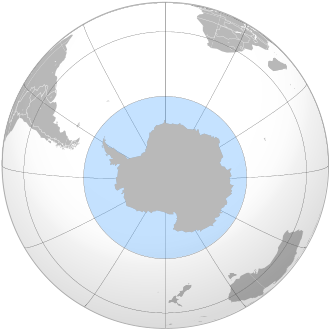
contains the waters that surround Antarctica and sometimes is considered an extension of Pacific, Atlantic and Indian Oceans.
The 1937 second edition of the International Hydrographic Organization
's (IHO) Limits of Oceans and Seas publication included a definition of an ocean around Antarctica. However, this ocean did not appear in the 1953 third edition because "the northern limits ... are difficult to lay down owing to their seasonal change" - instead the Atlantic, Indian and Pacific Oceans were extended southward.
The IHO readdressed the question of the ocean's existence in a survey in 2000. Of its 68 member nations, 28 responded, and all responding members except Argentina
agreed to define a new ocean, reflecting the importance placed by oceanographers on ocean currents. The proposal for the name Southern Ocean won 18 votes, beating the alternative Antarctic Ocean. Half of the votes supported a definition of the ocean's northern limit at 60°S
(with no land interruptions at this latitude), with the other 14 votes cast for other definitions, mostly 50°S
, but a few for as far north as 35°S
. However, the 4th edition of Limits of Oceans and Seas was never ratified or published due to a reservation lodged by Australia, and so the 3rd edition (which does not delineate a separate Southern Ocean) has not been superseded. If and when the 4th edition is published, it will restore the Southern Ocean as originally outlined in the 2nd edition and subsequently omitted from the 3rd.
Despite this, the 4th edition definition has de facto usage by many organisations, scientists and nations - even by the IHO. Some nations' hydrographic offices have defined their own boundaries; the United Kingdom used the 55°S parallel
for example.
Other sources such as the National Geographic Society
continue to show the Atlantic
, Pacific
and Indian
Oceans as extending to Antarctica, although articles on the National Geographic web site have begun to reference the Southern Ocean.
In Australia
, cartographical authorities defined the Southern Ocean as including the entire body of water between Antarctica and the south coasts of Australia and New Zealand
, although New Zealand authorities do not generally follow suit. Coastal maps of Tasmania
and South Australia
label the sea areas as Southern Ocean, while Cape Leeuwin
in Western Australia
is described as the point where the Indian and Southern Oceans meet.