
Borders of the continents
Encyclopedia
Continent
A continent is one of several very large landmasses on Earth. They are generally identified by convention rather than any strict criteria, with seven regions commonly regarded as continents—they are : Asia, Africa, North America, South America, Antarctica, Europe, and Australia.Plate tectonics is...
s of the topography
Topography
Topography is the study of Earth's surface shape and features or those ofplanets, moons, and asteroids...
of Earth
Earth
Earth is the third planet from the Sun, and the densest and fifth-largest of the eight planets in the Solar System. It is also the largest of the Solar System's four terrestrial planets...
are a matter of geographical
Geography
Geography is the science that studies the lands, features, inhabitants, and phenomena of Earth. A literal translation would be "to describe or write about the Earth". The first person to use the word "geography" was Eratosthenes...
convention.
Several slightly different conventions are in use, just as the number of continents is most commonly considered to be seven but may range as low as five, depending on whether the Americas
Americas
The Americas, or America , are lands in the Western hemisphere, also known as the New World. In English, the plural form the Americas is often used to refer to the landmasses of North America and South America with their associated islands and regions, while the singular form America is primarily...
and Eurasia
Eurasia
Eurasia is a continent or supercontinent comprising the traditional continents of Europe and Asia ; covering about 52,990,000 km2 or about 10.6% of the Earth's surface located primarily in the eastern and northern hemispheres...
are each considered a single continent.
According to the definition of a continent in the strict sense, an island
Island
An island or isle is any piece of sub-continental land that is surrounded by water. Very small islands such as emergent land features on atolls can be called islets, cays or keys. An island in a river or lake may be called an eyot , or holm...
cannot be part of any continent, but in practice most major islands are associated with a continent by convention.
There are three overland boundaries subject to definition:
- between AsiaAsiaAsia is the world's largest and most populous continent, located primarily in the eastern and northern hemispheres. It covers 8.7% of the Earth's total surface area and with approximately 3.879 billion people, it hosts 60% of the world's current human population...
and AfricaAfricaAfrica is the world's second largest and second most populous continent, after Asia. At about 30.2 million km² including adjacent islands, it covers 6% of the Earth's total surface area and 20.4% of the total land area...
(dividing Afro-EurasiaAfro-EurasiaAfro-Eurasia or less commonly Afrasia or Eurafrasia is the term used to describe the largest landmass on earth. It may be defined as a supercontinent, consisting of Africa and Eurasia...
into Africa and EurasiaEurasiaEurasia is a continent or supercontinent comprising the traditional continents of Europe and Asia ; covering about 52,990,000 km2 or about 10.6% of the Earth's surface located primarily in the eastern and northern hemispheres...
): at the Isthmus of SuezIsthmus of SuezThe Isthmus of Suez is the narrow strip land that lies between the Mediterranean Sea and the Red Sea, linking the continents of Africa and Asia. It contains the country of Egypt and the Suez Canal. Like many isthmuses, it is a location of great strategic value.... - between Asia and EuropeEuropeEurope is, by convention, one of the world's seven continents. Comprising the westernmost peninsula of Eurasia, Europe is generally 'divided' from Asia to its east by the watershed divides of the Ural and Caucasus Mountains, the Ural River, the Caspian and Black Seas, and the waterways connecting...
(dividing EurasiaEurasiaEurasia is a continent or supercontinent comprising the traditional continents of Europe and Asia ; covering about 52,990,000 km2 or about 10.6% of the Earth's surface located primarily in the eastern and northern hemispheres...
): along the BosporusBosporusThe Bosphorus or Bosporus , also known as the Istanbul Strait , is a strait that forms part of the boundary between Europe and Asia. It is one of the Turkish Straits, along with the Dardanelles...
, the CaucasusCaucasusThe Caucasus, also Caucas or Caucasia , is a geopolitical region at the border of Europe and Asia, and situated between the Black and the Caspian sea...
and the Urals (historically also north of the Caucasus, along the Kuma–Manych Depression or along the Don RiverDon River (Russia)The Don River is one of the major rivers of Russia. It rises in the town of Novomoskovsk 60 kilometres southeast from Tula, southeast of Moscow, and flows for a distance of about 1,950 kilometres to the Sea of Azov....
) - between North AmericaNorth AmericaNorth America is a continent wholly within the Northern Hemisphere and almost wholly within the Western Hemisphere. It is also considered a northern subcontinent of the Americas...
and South AmericaSouth AmericaSouth America is a continent situated in the Western Hemisphere, mostly in the Southern Hemisphere, with a relatively small portion in the Northern Hemisphere. The continent is also considered a subcontinent of the Americas. It is bordered on the west by the Pacific Ocean and on the north and east...
(dividing the AmericasAmericasThe Americas, or America , are lands in the Western hemisphere, also known as the New World. In English, the plural form the Americas is often used to refer to the landmasses of North America and South America with their associated islands and regions, while the singular form America is primarily...
): the Isthmus of PanamaIsthmus of PanamaThe Isthmus of Panama, also historically known as the Isthmus of Darien, is the narrow strip of land that lies between the Caribbean Sea and the Pacific Ocean, linking North and South America. It contains the country of Panama and the Panama Canal...
While the isthmus between Asia and Africa and that between the two Americas are today navigable, via the Suez
Suez Canal
The Suez Canal , also known by the nickname "The Highway to India", is an artificial sea-level waterway in Egypt, connecting the Mediterranean Sea and the Red Sea. Opened in November 1869 after 10 years of construction work, it allows water transportation between Europe and Asia without navigation...
and Panama
Panama Canal
The Panama Canal is a ship canal in Panama that joins the Atlantic Ocean and the Pacific Ocean and is a key conduit for international maritime trade. Built from 1904 to 1914, the canal has seen annual traffic rise from about 1,000 ships early on to 14,702 vessels measuring a total of 309.6...
canals, man-made diversions and canals are generally not accepted on their own accord as continent-defining boundaries; the Suez Canal happens to traverse the isthmus
Isthmus
An isthmus is a narrow strip of land connecting two larger land areas usually with waterforms on either side.Canals are often built through isthmuses where they may be particularly advantageous to create a shortcut for marine transportation...
between the Mediterranean Sea
Mediterranean Sea
The Mediterranean Sea is a sea connected to the Atlantic Ocean surrounded by the Mediterranean region and almost completely enclosed by land: on the north by Anatolia and Europe, on the south by North Africa, and on the east by the Levant...
and Red Sea
Red Sea
The Red Sea is a seawater inlet of the Indian Ocean, lying between Africa and Asia. The connection to the ocean is in the south through the Bab el Mandeb strait and the Gulf of Aden. In the north, there is the Sinai Peninsula, the Gulf of Aqaba, and the Gulf of Suez...
, dividing Asia and Africa.
The remaining boundaries concern the association of islands and archipelagos with specific continents, notably:
- the delineation of Southeast AsiaSoutheast AsiaSoutheast Asia, South-East Asia, South East Asia or Southeastern Asia is a subregion of Asia, consisting of the countries that are geographically south of China, east of India, west of New Guinea and north of Australia. The region lies on the intersection of geological plates, with heavy seismic...
from AustralasiaAustralasiaAustralasia is a region of Oceania comprising Australia, New Zealand, the island of New Guinea, and neighbouring islands in the Pacific Ocean. The term was coined by Charles de Brosses in Histoire des navigations aux terres australes... - the delineation between Africa, Europe and Asia in the Mediterranean
- the delineation between Asia and Europe in the Arctic OceanArctic OceanThe Arctic Ocean, located in the Northern Hemisphere and mostly in the Arctic north polar region, is the smallest and shallowest of the world's five major oceanic divisions...
- the delineation between Europe and North America in the Atlantic
- the delineation between North and South America in the CaribbeanCaribbeanThe Caribbean is a crescent-shaped group of islands more than 2,000 miles long separating the Gulf of Mexico and the Caribbean Sea, to the west and south, from the Atlantic Ocean, to the east and north...
- the delineation of Asia from North America in the North Pacific
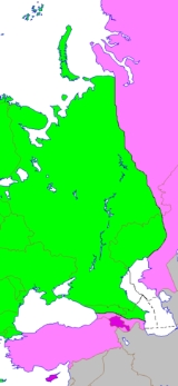
Europe and Asia
History
The threefold division of the Old WorldOld World
The Old World consists of those parts of the world known to classical antiquity and the European Middle Ages. It is used in the context of, and contrast with, the "New World" ....
into Europe, Asia and Africa has been in use since the 6th century BC, due to Greek geographers such as Anaximander
Anaximander
Anaximander was a pre-Socratic Greek philosopher who lived in Miletus, a city of Ionia; Milet in modern Turkey. He belonged to the Milesian school and learned the teachings of his master Thales...
and Hecataeus
Hecataeus
Hecataeus of Miletus , named after the Greek goddess Hecate, was an early Greek historian of a wealthy family. He flourished during the time of the Persian invasion. After having travelled extensively, he settled in his native city, where he occupied a high position, and devoted his time to the...
.
Anaximander placed the boundary between Asia and Europe along the Phasis River (the modern Rioni) in the Caucasus, a convention still followed by Herodotus
Herodotus
Herodotus was an ancient Greek historian who was born in Halicarnassus, Caria and lived in the 5th century BC . He has been called the "Father of History", and was the first historian known to collect his materials systematically, test their accuracy to a certain extent and arrange them in a...
in the 5th century BC.
As geographic knowledge of the Greeks increased during the Hellenistic period
Hellenistic period
The Hellenistic period or Hellenistic era describes the time which followed the conquests of Alexander the Great. It was so named by the historian J. G. Droysen. During this time, Greek cultural influence and power was at its zenith in Europe and Asia...
,
this archaic convention was revised, and the boundary between Europe and Asia was now considered to be the Tanais
Tanais
Tanais is the ancient name for the River Don in Russia. Strabo regarded it as the boundary between Europe and Asia.In antiquity, Tanais was also the name of a city in the Don river delta that reaches into the northeasternmost part of the Sea of Azov, which the Greeks called Lake Maeotis...
(the modern Don River). This is the convention used by Roman era authors such as Posidonius
Posidonius
Posidonius "of Apameia" or "of Rhodes" , was a Greek Stoic philosopher, politician, astronomer, geographer, historian and teacher native to Apamea, Syria. He was acclaimed as the greatest polymath of his age...
, Strabo
Strabo
Strabo, also written Strabon was a Greek historian, geographer and philosopher.-Life:Strabo was born to an affluent family from Amaseia in Pontus , a city which he said was situated the approximate equivalent of 75 km from the Black Sea...
and Ptolemy
Ptolemy
Claudius Ptolemy , was a Roman citizen of Egypt who wrote in Greek. He was a mathematician, astronomer, geographer, astrologer, and poet of a single epigram in the Greek Anthology. He lived in Egypt under Roman rule, and is believed to have been born in the town of Ptolemais Hermiou in the...
.
Throughout the Middle Ages and into the 18th century, the traditional division of the landmass of Eurasia
Eurasia
Eurasia is a continent or supercontinent comprising the traditional continents of Europe and Asia ; covering about 52,990,000 km2 or about 10.6% of the Earth's surface located primarily in the eastern and northern hemispheres...
into two continents Europe
Europe
Europe is, by convention, one of the world's seven continents. Comprising the westernmost peninsula of Eurasia, Europe is generally 'divided' from Asia to its east by the watershed divides of the Ural and Caucasus Mountains, the Ural River, the Caspian and Black Seas, and the waterways connecting...
and Asia
Asia
Asia is the world's largest and most populous continent, located primarily in the eastern and northern hemispheres. It covers 8.7% of the Earth's total surface area and with approximately 3.879 billion people, it hosts 60% of the world's current human population...
followed Ptolemy, with the boundary following the Agean Sea, the Dardanelles
Dardanelles
The Dardanelles , formerly known as the Hellespont, is a narrow strait in northwestern Turkey connecting the Aegean Sea to the Sea of Marmara. It is one of the Turkish Straits, along with its counterpart the Bosphorus. It is located at approximately...
, the Sea of Marmara
Sea of Marmara
The Sea of Marmara , also known as the Sea of Marmora or the Marmara Sea, and in the context of classical antiquity as the Propontis , is the inland sea that connects the Black Sea to the Aegean Sea, thus separating Turkey's Asian and European parts. The Bosphorus strait connects it to the Black...
, the Bosporus
Bosporus
The Bosphorus or Bosporus , also known as the Istanbul Strait , is a strait that forms part of the boundary between Europe and Asia. It is one of the Turkish Straits, along with the Dardanelles...
, the Black Sea
Black Sea
The Black Sea is bounded by Europe, Anatolia and the Caucasus and is ultimately connected to the Atlantic Ocean via the Mediterranean and the Aegean seas and various straits. The Bosphorus strait connects it to the Sea of Marmara, and the strait of the Dardanelles connects that sea to the Aegean...
, the Kerch Strait, the Sea of Azov
Sea of Azov
The Sea of Azov , known in Classical Antiquity as Lake Maeotis, is a sea on the south of Eastern Europe. It is linked by the narrow Strait of Kerch to the Black Sea to the south and is bounded on the north by Ukraine mainland, on the east by Russia, and on the west by the Ukraine's Crimean...
and the Don
Don River (Russia)
The Don River is one of the major rivers of Russia. It rises in the town of Novomoskovsk 60 kilometres southeast from Tula, southeast of Moscow, and flows for a distance of about 1,950 kilometres to the Sea of Azov....
(ancient Tanais
Tanais
Tanais is the ancient name for the River Don in Russia. Strabo regarded it as the boundary between Europe and Asia.In antiquity, Tanais was also the name of a city in the Don river delta that reaches into the northeasternmost part of the Sea of Azov, which the Greeks called Lake Maeotis...
).
But maps produced during the 16th to 18th century tended to differ in how to continue the boundary beyond the Don bend at Kalach-na-Donu
Kalach-na-Donu
Kalach-na-Donu , or Kalach-on-the-Don, is a town and the administrative center of Kalachyovsky District of Volgograd Oblast, Russia, located on the Don River west of Volgograd. Population: It was founded in 1708 as a Cossack sloboda...
(where it is closest to the Volga, now joined with it by the Volga–Don Canal), into territory not described in any detail by the ancient geographers.
Philip Johan von Strahlenberg
Philip Johan von Strahlenberg
Philip Johan von Strahlenberg was a Swedish officer and geographer of German origin who made important contributions to the cartography of Russia. Strahlenberg was born in Stralsund, which then belonged to Sweden, and his original name was Philip Johan Tabbert. He joined the Swedish army in 1694...
in 1725 was the first to depart from the classical Don boundary by drawing the line further east, from Kalach to the Volga, following the Volga north until the Samara bend
Samara bend
The Samara bend is a large hairpin bend of the middle Volga River at the confluence of the Samara River . It is situated in Samara Oblast, Volga Federal District of Russia....
, east along Obshchy Syrt
Obshchy Syrt
Obshchy Syrt is a highland ridge, or plateau , in the european part of Russia. It starts north of Orenburg as a branch of the Ural Mountains and runs in a southwesterly direction to the east bank of the Volga River....
(the drainage divide between Volga and Ural) and then north along Ural mountains
Ural Mountains
The Ural Mountains , or simply the Urals, are a mountain range that runs approximately from north to south through western Russia, from the coast of the Arctic Ocean to the Ural River and northwestern Kazakhstan. Their eastern side is usually considered the natural boundary between Europe and Asia...
. The mapmakers continued to differ on the boundary between the lower Don and Samara well into the 19th century. The 1745 atlas published by the Russian Empire
Russian Empire
The Russian Empire was a state that existed from 1721 until the Russian Revolution of 1917. It was the successor to the Tsardom of Russia and the predecessor of the Soviet Union...
has the boundary follow the Don beyond Kalach as far as Serafimovich
Serafimovich
Serafimovich is a town and the administrative center of Serafimovichsky District of Volgograd Oblast, Russia, located on the right bank of the Don River, northwest of Volgograd. Population:...
before cutting north towards Archangelsk, while other 18th to 19th century mapmakers such as John Cary
John Cary
John Cary was an 18th century English cartographer.Cary served his apprenticeship as an engraver in London, before setting up his own business in the Strand in 1783...
followed Strahlenberg's prescription. To the south, the Kuma-Manych Depression
Kuma-Manych Depression
The Kuma–Manych Depression , is a geological depression in southwestern Russia that separates the Russian Plain from the Fore-Caucasus...
was identified circa 1773 by a German naturalist Peter Simon Pallas
Peter Simon Pallas
Peter Simon Pallas was a German zoologist and botanist who worked in Russia.- Life and work :Pallas was born in Berlin, the son of Professor of Surgery Simon Pallas. He studied with private tutors and took an interest in natural history, later attending the University of Halle and the University...
as a valley that, once upon a time, connected the Black Sea and the Caspian Sea, and subsequently was proposed as a natural boundary between continents.
By the mid-19th century, there were three main conventions, one following the Don, the Volga–Don Canal and the Volga, the other following the Kuma-Manych Depression
Kuma-Manych Depression
The Kuma–Manych Depression , is a geological depression in southwestern Russia that separates the Russian Plain from the Fore-Caucasus...
to the Caspian and then the Ural River
Ural River
The Ural or Jayıq/Zhayyq , known as Yaik before 1775, is a river flowing through Russia and Kazakhstan. It arises in the southern Ural Mountains and ends at the Caspian Sea. Its total length is 1,511 mi making it the third longest river in Europe after the Volga and the Danube...
, and the third abandoning the Don altogether, following the Greater Caucasus watershed to the Caspian. The question was still treated as a "controversy" in geographical literature of the 1860s, with Douglas Freshfield
Douglas Freshfield
Douglas William Freshfield was a British lawyer, mountaineer and author, who edited the Alpine Journal from 1872 to 1880...
advocating the Caucasus crest boundary as the "best possible", citing support from various "modern geographers".
In Russia and the Soviet Union, the boundary along the Manych Depression was the most commonly used as early as 1906. In 1958, the Soviet Geographical Society formally recommended that the boundary between the Europe and Asia be drawn in textbooks along the eastern foot of Ural mountains, Emba river
Emba River
The Emba River in west Kazakhstan rises in the Mugodzhar Hills and flows some 400 miles southwest into the Caspian Sea. It flows through the north of the Ust-Urt plateau, and reaches the Caspian by a series of shallow lagoons, which were navigable in the 18th century. The lower course traverses...
, and Kuma-Manych depression, thus placing the Caucasus entirely in Asia and the Urals entirely in Europe. However, most geographers in the Soviet Union
Soviet Union
The Soviet Union , officially the Union of Soviet Socialist Republics , was a constitutionally socialist state that existed in Eurasia between 1922 and 1991....
favoured the boundary along the Caucasus crest and this became the standard convention in the latter 20th century, although the Kuma-Manych boundary remained in use in some 20th-century maps.
Modern definition
The modern definition of Europe delimits it from Asia at the Aegean SeaAegean Sea
The Aegean Sea[p] is an elongated embayment of the Mediterranean Sea located between the southern Balkan and Anatolian peninsulas, i.e., between the mainlands of Greece and Turkey. In the north, it is connected to the Marmara Sea and Black Sea by the Dardanelles and Bosporus...
, the Dardanelles
Dardanelles
The Dardanelles , formerly known as the Hellespont, is a narrow strait in northwestern Turkey connecting the Aegean Sea to the Sea of Marmara. It is one of the Turkish Straits, along with its counterpart the Bosphorus. It is located at approximately...
-Sea of Marmora-Bosporus
Bosporus
The Bosphorus or Bosporus , also known as the Istanbul Strait , is a strait that forms part of the boundary between Europe and Asia. It is one of the Turkish Straits, along with the Dardanelles...
, the Black Sea
Black Sea
The Black Sea is bounded by Europe, Anatolia and the Caucasus and is ultimately connected to the Atlantic Ocean via the Mediterranean and the Aegean seas and various straits. The Bosphorus strait connects it to the Sea of Marmara, and the strait of the Dardanelles connects that sea to the Aegean...
, along the watershed of the Greater Caucasus
Greater Caucasus
Greater Caucasus , sometimes translated as "Caucasus Major", "Big Caucasus" or "Large Caucasus") is the major mountain range of the Caucasus Mountains....
, the northwestern portion of the Caspian Sea
Caspian Sea
The Caspian Sea is the largest enclosed body of water on Earth by area, variously classed as the world's largest lake or a full-fledged sea. The sea has a surface area of and a volume of...
and along the Ural River
Ural River
The Ural or Jayıq/Zhayyq , known as Yaik before 1775, is a river flowing through Russia and Kazakhstan. It arises in the southern Ural Mountains and ends at the Caspian Sea. Its total length is 1,511 mi making it the third longest river in Europe after the Volga and the Danube...
and Ural Mountains
Ural Mountains
The Ural Mountains , or simply the Urals, are a mountain range that runs approximately from north to south through western Russia, from the coast of the Arctic Ocean to the Ural River and northwestern Kazakhstan. Their eastern side is usually considered the natural boundary between Europe and Asia...
, as both mapped and listed in many atlases including that of the National Geographic Society
National Geographic Society
The National Geographic Society , headquartered in Washington, D.C. in the United States, is one of the largest non-profit scientific and educational institutions in the world. Its interests include geography, archaeology and natural science, the promotion of environmental and historical...
and as described in the World Factbook.
According to this definition, Georgia
Georgia (country)
Georgia is a sovereign state in the Caucasus region of Eurasia. Located at the crossroads of Western Asia and Eastern Europe, it is bounded to the west by the Black Sea, to the north by Russia, to the southwest by Turkey, to the south by Armenia, and to the southeast by Azerbaijan. The capital of...
and Azerbaijan
Azerbaijan
Azerbaijan , officially the Republic of Azerbaijan is the largest country in the Caucasus region of Eurasia. Located at the crossroads of Western Asia and Eastern Europe, it is bounded by the Caspian Sea to the east, Russia to the north, Georgia to the northwest, Armenia to the west, and Iran to...
both have most of their territory in Asia, although each has small parts of their northern borderlands north of the Greater Caucasus watershed and thus in Europe.
The Turkish city Istanbul
Istanbul
Istanbul , historically known as Byzantium and Constantinople , is the largest city of Turkey. Istanbul metropolitan province had 13.26 million people living in it as of December, 2010, which is 18% of Turkey's population and the 3rd largest metropolitan area in Europe after London and...
lies in on both sides of the Bosporus, making it a transcontinental city.
Russia
Russia
Russia or , officially known as both Russia and the Russian Federation , is a country in northern Eurasia. It is a federal semi-presidential republic, comprising 83 federal subjects...
and Turkey
Turkey
Turkey , known officially as the Republic of Turkey , is a Eurasian country located in Western Asia and in East Thrace in Southeastern Europe...
are transcontinental countries with territory in both Europe and Asia by any definition.
While Russia is historically a European country with a history of imperial conquests
Russian Empire
The Russian Empire was a state that existed from 1721 until the Russian Revolution of 1917. It was the successor to the Tsardom of Russia and the predecessor of the Soviet Union...
in Asia, the situation for Turkey is inverse, as that of an Asian country with imperial conquests
Ottoman Empire
The Ottoman EmpireIt was usually referred to as the "Ottoman Empire", the "Turkish Empire", the "Ottoman Caliphate" or more commonly "Turkey" by its contemporaries...
in Europe.
Kazakhstan
Kazakhstan
Kazakhstan , officially the Republic of Kazakhstan, is a transcontinental country in Central Asia and Eastern Europe. Ranked as the ninth largest country in the world, it is also the world's largest landlocked country; its territory of is greater than Western Europe...
is also a transcontinental country by this definition, its West Kazakhstan
West Kazakhstan Province
West Kazakhstan Province is a province of Kazakhstan. Its capital is Oral , a city of about 200,000 inhabitants.-Geography:...
and Atyrau
Atyrau Province
Atyrau Oblast is a province of Kazakhstan. It is situated in the west of the country around the northeast of the Caspian Sea. Its capital is the city of Atyrau, with a population of 142,500 people; the province itself has 480,000 people...
provinces extending on either side of the Ural River.
The Kuma–Manych Depression (more precisely, the Manych River
Manych River
Manych is a river in the western and central part of the Kuma-Manych Depression in southern Russia.Tributary to the river Don. The river is 219 km long; its source is Lake Manych-Gudilo in the south-westerm part of the Russian republic of Kalmykia...
, the Kuma–Manych Canal and the Kuma River
Kuma River (Russia)
The Kuma is an long river in southern Russia. Its drainage basin is 33 500 square km. Its source is in the Greater Caucasus, in the republic Karachay-Cherkessia, west of Kislovodsk...
) remains cited less commonly as one possible natural boundary in contemporary sources.
There are other definitions for Europe and Asia limits, such as political definitions made by:
- The United Nations Statistics Division lists transcontinental countries under the continent in which they have the majority of their population:
- listed as part of Eastern EuropeEastern EuropeEastern Europe is the eastern part of Europe. The term has widely disparate geopolitical, geographical, cultural and socioeconomic readings, which makes it highly context-dependent and even volatile, and there are "almost as many definitions of Eastern Europe as there are scholars of the region"...
: Russian Federation - listed as part of Central AsiaCentral AsiaCentral Asia is a core region of the Asian continent from the Caspian Sea in the west, China in the east, Afghanistan in the south, and Russia in the north...
: KazakhstanKazakhstanKazakhstan , officially the Republic of Kazakhstan, is a transcontinental country in Central Asia and Eastern Europe. Ranked as the ninth largest country in the world, it is also the world's largest landlocked country; its territory of is greater than Western Europe... - listed as part of Western Asia: AzerbaijanAzerbaijanAzerbaijan , officially the Republic of Azerbaijan is the largest country in the Caucasus region of Eurasia. Located at the crossroads of Western Asia and Eastern Europe, it is bounded by the Caspian Sea to the east, Russia to the north, Georgia to the northwest, Armenia to the west, and Iran to...
, GeorgiaGeorgia (country)Georgia is a sovereign state in the Caucasus region of Eurasia. Located at the crossroads of Western Asia and Eastern Europe, it is bounded to the west by the Black Sea, to the north by Russia, to the southwest by Turkey, to the south by Armenia, and to the southeast by Azerbaijan. The capital of...
, TurkeyTurkeyTurkey , known officially as the Republic of Turkey , is a Eurasian country located in Western Asia and in East Thrace in Southeastern Europe...
and CyprusCyprusCyprus , officially the Republic of Cyprus , is a Eurasian island country, member of the European Union, in the Eastern Mediterranean, east of Greece, south of Turkey, west of Syria and north of Egypt. It is the third largest island in the Mediterranean Sea.The earliest known human activity on the...
- listed as part of Eastern Europe
- The Council of EuropeCouncil of EuropeThe Council of Europe is an international organisation promoting co-operation between all countries of Europe in the areas of legal standards, human rights, democratic development, the rule of law and cultural co-operation...
statute for membership:- Members include: Russian Federation, ArmeniaArmeniaArmenia , officially the Republic of Armenia , is a landlocked mountainous country in the Caucasus region of Eurasia...
, GeorgiaGeorgia (country)Georgia is a sovereign state in the Caucasus region of Eurasia. Located at the crossroads of Western Asia and Eastern Europe, it is bounded to the west by the Black Sea, to the north by Russia, to the southwest by Turkey, to the south by Armenia, and to the southeast by Azerbaijan. The capital of...
, AzerbaijanAzerbaijanAzerbaijan , officially the Republic of Azerbaijan is the largest country in the Caucasus region of Eurasia. Located at the crossroads of Western Asia and Eastern Europe, it is bounded by the Caspian Sea to the east, Russia to the north, Georgia to the northwest, Armenia to the west, and Iran to...
, TurkeyTurkeyTurkey , known officially as the Republic of Turkey , is a Eurasian country located in Western Asia and in East Thrace in Southeastern Europe...
and CyprusCyprusCyprus , officially the Republic of Cyprus , is a Eurasian island country, member of the European Union, in the Eastern Mediterranean, east of Greece, south of Turkey, west of Syria and north of Egypt. It is the third largest island in the Mediterranean Sea.The earliest known human activity on the... - Although not a member, KazakhstanKazakhstanKazakhstan , officially the Republic of Kazakhstan, is a transcontinental country in Central Asia and Eastern Europe. Ranked as the ninth largest country in the world, it is also the world's largest landlocked country; its territory of is greater than Western Europe...
is granted the right to request full membership
- Members include: Russian Federation, Armenia
Islands
The geographical notion of a continentContinent
A continent is one of several very large landmasses on Earth. They are generally identified by convention rather than any strict criteria, with seven regions commonly regarded as continents—they are : Asia, Africa, North America, South America, Antarctica, Europe, and Australia.Plate tectonics is...
stands in opposition to islands and archipelagos.
Nevertheless, there are some islands that are considered part of Europe in a political sense.
This most notably includes the British Isles
British Isles
The British Isles are a group of islands off the northwest coast of continental Europe that include the islands of Great Britain and Ireland and over six thousand smaller isles. There are two sovereign states located on the islands: the United Kingdom of Great Britain and Northern Ireland and...
, besides the islands of the North Sea
North Sea
In the southwest, beyond the Straits of Dover, the North Sea becomes the English Channel connecting to the Atlantic Ocean. In the east, it connects to the Baltic Sea via the Skagerrak and Kattegat, narrow straits that separate Denmark from Norway and Sweden respectively...
, the Baltic Sea
Baltic Sea
The Baltic Sea is a brackish mediterranean sea located in Northern Europe, from 53°N to 66°N latitude and from 20°E to 26°E longitude. It is bounded by the Scandinavian Peninsula, the mainland of Europe, and the Danish islands. It drains into the Kattegat by way of the Øresund, the Great Belt and...
and the Mediterranean which are part of the territory of a country situated on the European mainland, and usually also the island states of Iceland
Iceland
Iceland , described as the Republic of Iceland, is a Nordic and European island country in the North Atlantic Ocean, on the Mid-Atlantic Ridge. Iceland also refers to the main island of the country, which contains almost all the population and almost all the land area. The country has a population...
and Malta
Malta
Malta , officially known as the Republic of Malta , is a Southern European country consisting of an archipelago situated in the centre of the Mediterranean, south of Sicily, east of Tunisia and north of Libya, with Gibraltar to the west and Alexandria to the east.Malta covers just over in...
.
Russia's Vaygach Island
Vaygach Island
Vaygach Island is an island in the Arctic Sea between the Pechora Sea and the Kara Sea.Vaygach Island is separated from the Yugorsky Peninsula in the mainland by the Yugorsky Strait and from Novaya Zemlya by the Kara Strait...
and Novaya Zemlya
Novaya Zemlya
Novaya Zemlya , also known in Dutch as Nova Zembla and in Norwegian as , is an archipelago in the Arctic Ocean in the north of Russia and the extreme northeast of Europe, the easternmost point of Europe lying at Cape Flissingsky on the northern island...
extend northward from the northern end of the Ural Mountains
Ural Mountains
The Ural Mountains , or simply the Urals, are a mountain range that runs approximately from north to south through western Russia, from the coast of the Arctic Ocean to the Ural River and northwestern Kazakhstan. Their eastern side is usually considered the natural boundary between Europe and Asia...
and are a continuation of that chain into the Arctic Ocean
Arctic Ocean
The Arctic Ocean, located in the Northern Hemisphere and mostly in the Arctic north polar region, is the smallest and shallowest of the world's five major oceanic divisions...
. While Novaya Zemlya was variously grouped with Europe or with Asia in 19th century maps, it is now usually grouped with Europe, the continental boundary considered to join the Arctic Ocean along the southern shore of the Kara Sea
Kara Sea
The Kara Sea is part of the Arctic Ocean north of Siberia. It is separated from the Barents Sea to the west by the Kara Strait and Novaya Zemlya, and the Laptev Sea to the east by the Severnaya Zemlya....
. The Russian Arctic archipelago
Archipelago
An archipelago , sometimes called an island group, is a chain or cluster of islands. The word archipelago is derived from the Greek ἄρχι- – arkhi- and πέλαγος – pélagos through the Italian arcipelago...
of Franz Josef Land
Franz Josef Land
Franz Josef Land, Franz Joseph Land, or Francis Joseph's Land is an archipelago located in the far north of Russia. It is found in the Arctic Ocean north of Novaya Zemlya and east of Svalbard, and is administered by Arkhangelsk Oblast. Franz Josef Land consists of 191 ice-covered islands with a...
farther north is also associated with Europe.
Europe ends in the west at the Atlantic Ocean
Atlantic Ocean
The Atlantic Ocean is the second-largest of the world's oceanic divisions. With a total area of about , it covers approximately 20% of the Earth's surface and about 26% of its water surface area...
, although Iceland
Iceland
Iceland , described as the Republic of Iceland, is a Nordic and European island country in the North Atlantic Ocean, on the Mid-Atlantic Ridge. Iceland also refers to the main island of the country, which contains almost all the population and almost all the land area. The country has a population...
and the Azores
Azores
The Archipelago of the Azores is composed of nine volcanic islands situated in the middle of the North Atlantic Ocean, and is located about west from Lisbon and about east from the east coast of North America. The islands, and their economic exclusion zone, form the Autonomous Region of the...
archipelago
Archipelago
An archipelago , sometimes called an island group, is a chain or cluster of islands. The word archipelago is derived from the Greek ἄρχι- – arkhi- and πέλαγος – pélagos through the Italian arcipelago...
(in the Atlantic, between Europe and North America) are usually considered European, as is the Norwegian Svalbard
Svalbard
Svalbard is an archipelago in the Arctic, constituting the northernmost part of Norway. It is located north of mainland Europe, midway between mainland Norway and the North Pole. The group of islands range from 74° to 81° north latitude , and from 10° to 35° east longitude. Spitsbergen is the...
archipelago in the Arctic Ocean
Arctic Ocean
The Arctic Ocean, located in the Northern Hemisphere and mostly in the Arctic north polar region, is the smallest and shallowest of the world's five major oceanic divisions...
. Greenland
Greenland
Greenland is an autonomous country within the Kingdom of Denmark, located between the Arctic and Atlantic Oceans, east of the Canadian Arctic Archipelago. Though physiographically a part of the continent of North America, Greenland has been politically and culturally associated with Europe for...
is geographically part of North America, but politically associated with Europe as it is part of the Kingdom of Denmark
Kingdom of Denmark
The Kingdom of Denmark or the Danish Realm , is a constitutional monarchy and sovereign state consisting of Denmark proper in northern Europe and two autonomous constituent countries, the Faroe Islands in the North Atlantic and Greenland in North America. Denmark is the hegemonial part, where the...
, although it has extensive home rule and EU law no longer applies there.
Cyprus
Cyprus
Cyprus , officially the Republic of Cyprus , is a Eurasian island country, member of the European Union, in the Eastern Mediterranean, east of Greece, south of Turkey, west of Syria and north of Egypt. It is the third largest island in the Mediterranean Sea.The earliest known human activity on the...
is an island of the Mediterranean but located close to Asia Minor
Asia Minor
Asia Minor is a geographical location at the westernmost protrusion of Asia, also called Anatolia, and corresponds to the western two thirds of the Asian part of Turkey...
, so that it is usually associated with Asia and/or the Middle East
Middle East
The Middle East is a region that encompasses Western Asia and Northern Africa. It is often used as a synonym for Near East, in opposition to Far East...
, as in the World Factbook, but it was nevertheless admitted to the Council of Europe in 1961 and joined the EU in 2004.
North Aegean Islands
Aegean Islands
The Aegean Islands are the group of islands in the Aegean Sea, with mainland Greece to the west and north and Turkey to the east; the island of Crete delimits the sea to the south, those of Rhodes, Karpathos and Kasos to the southeast...
and the Dodecanese
Dodecanese
The Dodecanese are a group of 12 larger plus 150 smaller Greek islands in the Aegean Sea, of which 26 are inhabited. Τhis island group generally defines the eastern limit of the Sea of Crete. They belong to the Southern Sporades island group...
lie on the coast of Asian Turkey (Asian continental shelf), but are politically part of Greece
Greece
Greece , officially the Hellenic Republic , and historically Hellas or the Republic of Greece in English, is a country in southeastern Europe....
, a European country.
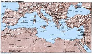
Africa and Asia
Africa
Africa is the world's second largest and second most populous continent, after Asia. At about 30.2 million km² including adjacent islands, it covers 6% of the Earth's total surface area and 20.4% of the total land area...
are the Mediterranean Sea
Mediterranean Sea
The Mediterranean Sea is a sea connected to the Atlantic Ocean surrounded by the Mediterranean region and almost completely enclosed by land: on the north by Anatolia and Europe, on the south by North Africa, and on the east by the Levant...
, the Red Sea
Red Sea
The Red Sea is a seawater inlet of the Indian Ocean, lying between Africa and Asia. The connection to the ocean is in the south through the Bab el Mandeb strait and the Gulf of Aden. In the north, there is the Sinai Peninsula, the Gulf of Aqaba, and the Gulf of Suez...
, and the Gulf of Aden
Gulf of Aden
The Gulf of Aden is located in the Arabian Sea between Yemen, on the south coast of the Arabian Peninsula, and Somalia in the Horn of Africa. In the northwest, it connects with the Red Sea through the Bab-el-Mandeb strait, which is about 20 miles wide....
. The usual line taken to divide Africa from Asia today is at the Isthmus of Suez, the narrowest gap between the Mediterranean Sea
Mediterranean Sea
The Mediterranean Sea is a sea connected to the Atlantic Ocean surrounded by the Mediterranean region and almost completely enclosed by land: on the north by Anatolia and Europe, on the south by North Africa, and on the east by the Levant...
and Gulf of Suez
Gulf of Suez
The northern end of the Red Sea is bifurcated by the Sinai Peninsula, creating the Gulf of Suez in the west and the Gulf of Aqaba to the east. The Gulf of Suez is formed within a relatively young, but now inactive rift basin, the Gulf of Suez Rift, dating back about 28 million years...
, a route today followed by the Suez Canal
Suez Canal
The Suez Canal , also known by the nickname "The Highway to India", is an artificial sea-level waterway in Egypt, connecting the Mediterranean Sea and the Red Sea. Opened in November 1869 after 10 years of construction work, it allows water transportation between Europe and Asia without navigation...
. This makes the Sinai Peninsula
Sinai Peninsula
The Sinai Peninsula or Sinai is a triangular peninsula in Egypt about in area. It is situated between the Mediterranean Sea to the north, and the Red Sea to the south, and is the only part of Egyptian territory located in Asia as opposed to Africa, effectively serving as a land bridge between two...
geographically Asian, and Egypt
Egypt
Egypt , officially the Arab Republic of Egypt, Arabic: , is a country mainly in North Africa, with the Sinai Peninsula forming a land bridge in Southwest Asia. Egypt is thus a transcontinental country, and a major power in Africa, the Mediterranean Basin, the Middle East and the Muslim world...
a transcontinental country.
Less than 2% of Egyptian population live in the Sinai, and hence Egypt even though technically transcontinental is usually considered an African country.
But when discussing the geopolitical region of the Middle East and North Africa
MENA
The term MENA, for "Middle East and North Africa", is an acronym often used in academic, military planning and business writing.The term covers an extensive region, extending from Morocco to Iran, including the majority of both the Middle Eastern and Maghreb countries...
, Egypt is usually grouped with the Asian countries as part of the Middle East
Middle East
The Middle East is a region that encompasses Western Asia and Northern Africa. It is often used as a synonym for Near East, in opposition to Far East...
, while Egypt's western neighbor Libya
Libya
Libya is an African country in the Maghreb region of North Africa bordered by the Mediterranean Sea to the north, Egypt to the east, Sudan to the southeast, Chad and Niger to the south, and Algeria and Tunisia to the west....
is grouped with the remaining North African countries as the Maghreb
Maghreb
The Maghreb is the region of Northwest Africa, west of Egypt. It includes five countries: Morocco, Algeria, Tunisia, Libya, and Mauritania and the disputed territory of Western Sahara...
.
Historically, in Greco-Roman geography, Egypt was also considered part of Asia, and Africa (Libya
Ancient Libya
The Latin name Libya referred to the region west of the Nile Valley, generally corresponding to modern Northwest Africa. Climate changes affected the locations of the settlements....
) was taken to begin in Marmarica
Marmarica
Marmarica in ancient geography referred to the part of the North African coast between Cyrenaica and Aegyptus.It corresponds to what is now the border region between Libya and Egypt, including the towns of Bomba , Timimi , Tobruk , Acroma , Bardiya, As-Salum, Sidi Barrani .It...
, at the Catabathmus Magnus.
The Seychelles
Seychelles
Seychelles , officially the Republic of Seychelles , is an island country spanning an archipelago of 115 islands in the Indian Ocean, some east of mainland Africa, northeast of the island of Madagascar....
, Mauritius
Mauritius
Mauritius , officially the Republic of Mauritius is an island nation off the southeast coast of the African continent in the southwest Indian Ocean, about east of Madagascar...
, and Comoros
Comoros
The Comoros , officially the Union of the Comoros is an archipelago island nation in the Indian Ocean, located off the eastern coast of Africa, on the northern end of the Mozambique Channel, between northeastern Mozambique and northwestern Madagascar...
are island nations in the Indian ocean
Indian Ocean
The Indian Ocean is the third largest of the world's oceanic divisions, covering approximately 20% of the water on the Earth's surface. It is bounded on the north by the Indian Subcontinent and Arabian Peninsula ; on the west by eastern Africa; on the east by Indochina, the Sunda Islands, and...
associated with Africa. The island of Socotra
Socotra
Socotra , also spelt Soqotra, is a small archipelago of four islands in the Indian Ocean. The largest island, also called Socotra, is about 95% of the landmass of the archipelago. It lies some east of the Horn of Africa and south of the Arabian Peninsula. The island is very isolated and through...
may be considered African as it lies on this continent's shelf, but is part of Yemen
Yemen
The Republic of Yemen , commonly known as Yemen , is a country located in the Middle East, occupying the southwestern to southern end of the Arabian Peninsula. It is bordered by Saudi Arabia to the north, the Red Sea to the west, and Oman to the east....
, an Asian country.
Africa and Europe
Africa
Africa is the world's second largest and second most populous continent, after Asia. At about 30.2 million km² including adjacent islands, it covers 6% of the Earth's total surface area and 20.4% of the total land area...
n mainlands are non-contiguous, and the delineation between these continents is thus merely a question of which islands are to be associated with which continent.
Sicily
Sicily
Sicily is a region of Italy, and is the largest island in the Mediterranean Sea. Along with the surrounding minor islands, it constitutes an autonomous region of Italy, the Regione Autonoma Siciliana Sicily has a rich and unique culture, especially with regard to the arts, music, literature,...
and Malta
Malta
Malta , officially known as the Republic of Malta , is a Southern European country consisting of an archipelago situated in the centre of the Mediterranean, south of Sicily, east of Tunisia and north of Libya, with Gibraltar to the west and Alexandria to the east.Malta covers just over in...
are usually grouped with Europe, while the Pelagie Islands
Pelagie Islands
The Pelagie Islands , from the Greek pélagos - πέλαγος meaning "open sea", are the three small islands of Lampedusa, Linosa, and Lampione, located in the Mediterranean Sea between Malta and Tunisia, south of Sicily. To the northwest lie the island of Pantelleria and the Strait of Sicily...
are often grouped with Africa.
The Portuguese Atlantic island possession of the Azores
Azores
The Archipelago of the Azores is composed of nine volcanic islands situated in the middle of the North Atlantic Ocean, and is located about west from Lisbon and about east from the east coast of North America. The islands, and their economic exclusion zone, form the Autonomous Region of the...
is slightly closer to Europe than Africa, and is usually grouped with Europe.
By contrast, the Canary
Canary Islands
The Canary Islands , also known as the Canaries , is a Spanish archipelago located just off the northwest coast of mainland Africa, 100 km west of the border between Morocco and the Western Sahara. The Canaries are a Spanish autonomous community and an outermost region of the European Union...
and Madeira islands off the Atlantic coast of Morocco
Morocco
Morocco , officially the Kingdom of Morocco , is a country located in North Africa. It has a population of more than 32 million and an area of 710,850 km², and also primarily administers the disputed region of the Western Sahara...
are usually grouped with Africa.
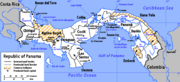
North and South America
Mainland
The border between North AmericaNorth America
North America is a continent wholly within the Northern Hemisphere and almost wholly within the Western Hemisphere. It is also considered a northern subcontinent of the Americas...
and South America
South America
South America is a continent situated in the Western Hemisphere, mostly in the Southern Hemisphere, with a relatively small portion in the Northern Hemisphere. The continent is also considered a subcontinent of the Americas. It is bordered on the west by the Pacific Ocean and on the north and east...
is at some point on the Isthmus of Panama
Isthmus of Panama
The Isthmus of Panama, also historically known as the Isthmus of Darien, is the narrow strip of land that lies between the Caribbean Sea and the Pacific Ocean, linking North and South America. It contains the country of Panama and the Panama Canal...
.
The most common demarcation in atlases and other sources follows the Darién Mountains
Darién Gap
The Darién Gap is a large swath of undeveloped swampland and forest separating Panama's Darién Province in Central America from Colombia in South America. It measures just over long and about wide. Roadbuilding through this area is expensive, and the environmental toll is steep. Political...
watershed divide along the Colombia
Colombia
Colombia, officially the Republic of Colombia , is a unitary constitutional republic comprising thirty-two departments. The country is located in northwestern South America, bordered to the east by Venezuela and Brazil; to the south by Ecuador and Peru; to the north by the Caribbean Sea; to the...
-Panama boundary where the isthmus meets the South American continent. Virtually all atlases list Panama as a state falling entirely within North America and/or Central America
Central America
Central America is the central geographic region of the Americas. It is the southernmost, isthmian portion of the North American continent, which connects with South America on the southeast. When considered part of the unified continental model, it is considered a subcontinent...
.
. Another demarcation, less common, reckons the continental divide at the man-made Panama Canal
Panama Canal
The Panama Canal is a ship canal in Panama that joins the Atlantic Ocean and the Pacific Ocean and is a key conduit for international maritime trade. Built from 1904 to 1914, the canal has seen annual traffic rise from about 1,000 ships early on to 14,702 vessels measuring a total of 309.6...
, which would place some Panamanian territory on both continents.
Islands
Often most of the Caribbean islands are considered part of North America, but ArubaAruba
Aruba is a 33 km-long island of the Lesser Antilles in the southern Caribbean Sea, located 27 km north of the coast of Venezuela and 130 km east of Guajira Peninsula...
, Bonaire, Curaçao
Curaçao
Curaçao is an island in the southern Caribbean Sea, off the Venezuelan coast. The Country of Curaçao , which includes the main island plus the small, uninhabited island of Klein Curaçao , is a constituent country of the Kingdom of the Netherlands...
, Trinidad and Tobago
Trinidad and Tobago
Trinidad and Tobago officially the Republic of Trinidad and Tobago is an archipelagic state in the southern Caribbean, lying just off the coast of northeastern Venezuela and south of Grenada in the Lesser Antilles...
lie on the continental shelf
Continental shelf
The continental shelf is the extended perimeter of each continent and associated coastal plain. Much of the shelf was exposed during glacial periods, but is now submerged under relatively shallow seas and gulfs, and was similarly submerged during other interglacial periods. The continental margin,...
of South America
South America
South America is a continent situated in the Western Hemisphere, mostly in the Southern Hemisphere, with a relatively small portion in the Northern Hemisphere. The continent is also considered a subcontinent of the Americas. It is bordered on the west by the Pacific Ocean and on the north and east...
. On the other hand, the Venezuelan Isla Aves
Isla Aves
Isla de Aves , or Aves Island, is a Caribbean dependency of Venezuela. It has been the subject of numerous territorial disputes between the neighboring independent islands, such as Dominica, and European mother countries of surrounding dependent islands, such as the Netherlands. It lies to the west...
and the Colombian San Andrés and Providencia lie on the North American shelf.
Europe and North America
Europe and North America are separated by the North Atlantic.In terms of associating islands with either continent, the boundary is usually drawn between Greenland
Greenland
Greenland is an autonomous country within the Kingdom of Denmark, located between the Arctic and Atlantic Oceans, east of the Canadian Arctic Archipelago. Though physiographically a part of the continent of North America, Greenland has been politically and culturally associated with Europe for...
and Iceland
Iceland
Iceland , described as the Republic of Iceland, is a Nordic and European island country in the North Atlantic Ocean, on the Mid-Atlantic Ridge. Iceland also refers to the main island of the country, which contains almost all the population and almost all the land area. The country has a population...
. The Norwegian islands of Jan Mayen
Jan Mayen
Jan Mayen Island is a volcanic island in the Arctic Ocean and part of the Kingdom of Norway. It is long and 373 km2 in area, partly covered by glaciers . It has two parts: larger northeast Nord-Jan and smaller Sør-Jan, linked by an isthmus wide...
and Svalbard
Svalbard
Svalbard is an archipelago in the Arctic, constituting the northernmost part of Norway. It is located north of mainland Europe, midway between mainland Norway and the North Pole. The group of islands range from 74° to 81° north latitude , and from 10° to 35° east longitude. Spitsbergen is the...
in the Arctic Ocean
Arctic Ocean
The Arctic Ocean, located in the Northern Hemisphere and mostly in the Arctic north polar region, is the smallest and shallowest of the world's five major oceanic divisions...
are usually associated with Europe. Iceland
Iceland
Iceland , described as the Republic of Iceland, is a Nordic and European island country in the North Atlantic Ocean, on the Mid-Atlantic Ridge. Iceland also refers to the main island of the country, which contains almost all the population and almost all the land area. The country has a population...
and the Azores
Azores
The Archipelago of the Azores is composed of nine volcanic islands situated in the middle of the North Atlantic Ocean, and is located about west from Lisbon and about east from the east coast of North America. The islands, and their economic exclusion zone, form the Autonomous Region of the...
are protrusions of the Mid-Atlantic Ridge
Mid-Atlantic Ridge
The Mid-Atlantic Ridge is a mid-ocean ridge, a divergent tectonic plate boundary located along the floor of the Atlantic Ocean, and part of the longest mountain range in the world. It separates the Eurasian Plate and North American Plate in the North Atlantic, and the African Plate from the South...
and are associated with and peopled from Europe
Europe
Europe is, by convention, one of the world's seven continents. Comprising the westernmost peninsula of Eurasia, Europe is generally 'divided' from Asia to its east by the watershed divides of the Ural and Caucasus Mountains, the Ural River, the Caspian and Black Seas, and the waterways connecting...
, even though they have areas on the North American plate
North American Plate
The North American Plate is a tectonic plate covering most of North America, Greenland, Cuba, Bahamas, and parts of Siberia, Japan and Iceland. It extends eastward to the Mid-Atlantic Ridge and westward to the Chersky Range in eastern Siberia. The plate includes both continental and oceanic crust...
. (Definitions of "continents" are a physical and cultural construct dating back centuries, long before the advent or even knowledge of plate tectonics
Plate tectonics
Plate tectonics is a scientific theory that describes the large scale motions of Earth's lithosphere...
; i.e., defining a "continent" falls into the realm of physical and cultural geography, while continental plate definitions fall under plate tectonics in the realm of geology.)
Asia and North America
The Bering StraitBering Strait
The Bering Strait , known to natives as Imakpik, is a sea strait between Cape Dezhnev, Chukotka Autonomous Okrug, Russia, the easternmost point of the Asian continent and Cape Prince of Wales, Alaska, USA, the westernmost point of the North American continent, with latitude of about 65°40'N,...
and Bering Sea
Bering Sea
The Bering Sea is a marginal sea of the Pacific Ocean. It comprises a deep water basin, which then rises through a narrow slope into the shallower water above the continental shelves....
separate the landmasses of Asia
Asia
Asia is the world's largest and most populous continent, located primarily in the eastern and northern hemispheres. It covers 8.7% of the Earth's total surface area and with approximately 3.879 billion people, it hosts 60% of the world's current human population...
and North America
North America
North America is a continent wholly within the Northern Hemisphere and almost wholly within the Western Hemisphere. It is also considered a northern subcontinent of the Americas...
, as well as forming the international boundary between Russia
Russia
Russia or , officially known as both Russia and the Russian Federation , is a country in northern Eurasia. It is a federal semi-presidential republic, comprising 83 federal subjects...
and the United States
United States
The United States of America is a federal constitutional republic comprising fifty states and a federal district...
. This national and continental boundary separates the Diomede Islands
Diomede Islands
The Diomede Islands , also known in Russia as Gvozdev Islands , consist of two rocky, tuya-like islands:* The U.S. island of Little Diomede or, in its native language, Ignaluk , and* The Russian island of Big Diomede , also known as Imaqliq,...
in the Bering Strait, with Big Diomede in Russia and Little Diomede in the US. The Aleutian Islands are an island chain extending westward from the Alaska Peninsula
Alaska Peninsula
The Alaska Peninsula is a peninsula extending about to the southwest from the mainland of Alaska and ending in the Aleutian Islands. The peninsula separates the Pacific Ocean from Bristol Bay, an arm of the Bering Sea....
toward Russia's Komandorski Islands
Komandorski Islands
Commander Islands or Komandorski Islands are a group of treeless Russian islands located east of the Kamchatka Peninsula in the Russian Far East, in the Bering Sea...
and Kamchatka Peninsula
Kamchatka Peninsula
The Kamchatka Peninsula is a peninsula in the Russian Far East, with an area of . It lies between the Pacific Ocean to the east and the Sea of Okhotsk to the west...
. Most of them are always associated with North America, except for the westernmost Near Islands
Near Islands
The Near Islands or Sasignan Islands are the smallest and westernmost group of the Aleutian Islands in southwestern Alaska.-Geography:The largest of the Near Islands are Attu and Agattu...
group, which is on Asia's continental shelf beyond the North Aleutians Basin
North Aleutians Basin
The North Aleutians Basin is a geographic phenomenon, primarily a submarine depression, occurring in the southern Bristol Bay region of the Bering Sea and just off the northern shore of the Alaska Peninsula. It extends some 600 miles along the Alaska Peninsula and nearly as far north-south into...
and on rare occasions could be associated with Asia, which could then allow the US to be considered a transcontinental country.
St. Lawrence Island
St. Lawrence Island
St. Lawrence Island is located west of mainland Alaska in the Bering Sea, just south of the Bering Strait, at about 63°30' North 173°20' West. The village of Gambell is located on the northwest cape, from the Chukchi Peninsula in the Russian Far East. The island is part of Alaska, but closer to...
in the northern Bering Sea belongs to Alaska and may be associated with either continent but are almost always considered part of North America, as with the Rat Islands
Rat Islands
The Rat Islands are a volcanic group of islands in the Aleutian Islands in southwest Alaska, between Buldir Island and the Near Islands group to its west, and Amchitka Pass and the Andreanof Islands group to its east, at about ....
in the Aleutian chain.
The Americas and Oceania
The Galápagos IslandsGalápagos Islands
The Galápagos Islands are an archipelago of volcanic islands distributed around the equator in the Pacific Ocean, west of continental Ecuador, of which they are a part.The Galápagos Islands and its surrounding waters form an Ecuadorian province, a national park, and a...
and Malpelo Island
Malpelo Island
Malpelo Island is an island located from Colombia's Pacific coast, and approximately from Panama's coast. It has a land area of . It is uninhabited except for a small military post manned by the Colombian Army, which was established in 1986. Visitors need a written permit from the Colombian...
in the eastern Pacific Ocean
Pacific Ocean
The Pacific Ocean is the largest of the Earth's oceanic divisions. It extends from the Arctic in the north to the Southern Ocean in the south, bounded by Asia and Australia in the west, and the Americas in the east.At 165.2 million square kilometres in area, this largest division of the World...
are possessions of Ecuador
Ecuador
Ecuador , officially the Republic of Ecuador is a representative democratic republic in South America, bordered by Colombia on the north, Peru on the east and south, and by the Pacific Ocean to the west. It is one of only two countries in South America, along with Chile, that do not have a border...
and Colombia
Colombia
Colombia, officially the Republic of Colombia , is a unitary constitutional republic comprising thirty-two departments. The country is located in northwestern South America, bordered to the east by Venezuela and Brazil; to the south by Ecuador and Peru; to the north by the Caribbean Sea; to the...
, respectively, and associated with South America
South America
South America is a continent situated in the Western Hemisphere, mostly in the Southern Hemisphere, with a relatively small portion in the Northern Hemisphere. The continent is also considered a subcontinent of the Americas. It is bordered on the west by the Pacific Ocean and on the north and east...
. The uninhabited French possession of Clipperton Island
Clipperton Island
Clipperton Island is an uninhabited nine-square-kilometre coral atoll in the eastern Pacific Ocean, southwest of Mexico and west of Central America, at...
600 miles (965.6 km) off the Mexican coast is associated with North America
North America
North America is a continent wholly within the Northern Hemisphere and almost wholly within the Western Hemisphere. It is also considered a northern subcontinent of the Americas...
.
Easter Island
Easter Island
Easter Island is a Polynesian island in the southeastern Pacific Ocean, at the southeasternmost point of the Polynesian triangle. A special territory of Chile that was annexed in 1888, Easter Island is famous for its 887 extant monumental statues, called moai, created by the early Rapanui people...
, a territory of Chile
Chile
Chile ,officially the Republic of Chile , is a country in South America occupying a long, narrow coastal strip between the Andes mountains to the east and the Pacific Ocean to the west. It borders Peru to the north, Bolivia to the northeast, Argentina to the east, and the Drake Passage in the far...
, is considered to be in Oceania, though politically it is associated with South America.
The United States
United States
The United States of America is a federal constitutional republic comprising fifty states and a federal district...
controls numerous territories in Oceania
Oceania
Oceania is a region centered on the islands of the tropical Pacific Ocean. Conceptions of what constitutes Oceania range from the coral atolls and volcanic islands of the South Pacific to the entire insular region between Asia and the Americas, including Australasia and the Malay Archipelago...
, including the state of Hawaii
Hawaii
Hawaii is the newest of the 50 U.S. states , and is the only U.S. state made up entirely of islands. It is the northernmost island group in Polynesia, occupying most of an archipelago in the central Pacific Ocean, southwest of the continental United States, southeast of Japan, and northeast of...
. These are politically associated with North America.
Asia and Oceania
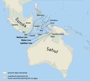
Malay Archipelago
The Malay Archipelago refers to the archipelago between mainland Southeastern Asia and Australia. The name was derived from the anachronistic concept of a Malay race....
is sometimes divided between Asia and Australasia
Australasia
Australasia is a region of Oceania comprising Australia, New Zealand, the island of New Guinea, and neighbouring islands in the Pacific Ocean. The term was coined by Charles de Brosses in Histoire des navigations aux terres australes...
, usually along the anthropologic Melanesian line or the Weber Line. Indonesia controls the western half of New Guinea
New Guinea
New Guinea is the world's second largest island, after Greenland, covering a land area of 786,000 km2. Located in the southwest Pacific Ocean, it lies geographically to the east of the Malay Archipelago, with which it is sometimes included as part of a greater Indo-Australian Archipelago...
, geographically part of Australasia. The eastern half of the island is part of Papua New Guinea
Papua New Guinea
Papua New Guinea , officially the Independent State of Papua New Guinea, is a country in Oceania, occupying the eastern half of the island of New Guinea and numerous offshore islands...
which is considered to be part of the Pacific. East Timor
East Timor
The Democratic Republic of Timor-Leste, commonly known as East Timor , is a state in Southeast Asia. It comprises the eastern half of the island of Timor, the nearby islands of Atauro and Jaco, and Oecusse, an exclave on the northwestern side of the island, within Indonesian West Timor...
, an independent state that was formerly a territory of Indonesia, which is geographically part of Asia, is classified by the United Nations
United Nations
The United Nations is an international organization whose stated aims are facilitating cooperation in international law, international security, economic development, social progress, human rights, and achievement of world peace...
as part of the "South-Eastern Asia" block. It is expected to join the Association of Southeast Asian Nations
Association of Southeast Asian Nations
The Association of Southeast Asian Nations, commonly abbreviated ASEAN rarely ), is a geo-political and economic organization of ten countries located in Southeast Asia, which was formed on 8 August 1967 by Indonesia, Malaysia, the Philippines, Singapore and Thailand. Since then, membership has...
http://www.smh.com.au/news/world/east-timor-asean-bid/2006/07/22/1153166635002.html, having been involved as an ASEAN Regional Forum member since independence, and has participated in the Southeast Asian Games
Southeast Asian Games
The Southeast Asian Games , is a biennial multi-sport event involving participants from the current 11 countries of Southeast Asia...
since 2003
2003 Southeast Asian Games
The 22nd Southeast Asian Games were held in Hanoi, Vietnam from 5 December - 13 December 2003. The games were opened by Vietnamese prime minister Phan Van Khai in the newly constructed My Dinh National Stadium in Hanoi. The games torch was lit by Nguyen Thuy Hien of Wushu...
. Occasionally, all of the Malay Archipelago
Malay Archipelago
The Malay Archipelago refers to the archipelago between mainland Southeastern Asia and Australia. The name was derived from the anachronistic concept of a Malay race....
is included in Oceania, although this is extremely rare, especially as most of the archipelago lies on the Asian continental shelf.
The Commonwealth of Australia includes island possessions in Oceania and closer to Indonesia than Australia.
Antarctica
Antarctica along with its outlying islands have no permanent population. All land claims south of 60°S latitude is held in abeyance by the Antarctic Treaty SystemAntarctic Treaty System
The Antarctic Treaty and related agreements, collectively called the Antarctic Treaty System or ATS, regulate international relations with respect to Antarctica, Earth's only continent without a native human population. For the purposes of the treaty system, Antarctica is defined as all of the land...
.
The South Georgia and the South Sandwich Islands
South Georgia and the South Sandwich Islands
South Georgia and the South Sandwich Islands is a British overseas territory and overseas territory of the European Union in the southern Atlantic Ocean. It is a remote and inhospitable collection of islands, consisting of South Georgia and a chain of smaller islands, known as the South Sandwich...
are closer to Antarctica than to any other continent. However, they are politically associated with the inhabited Falkland Islands
Falkland Islands
The Falkland Islands are an archipelago in the South Atlantic Ocean, located about from the coast of mainland South America. The archipelago consists of East Falkland, West Falkland and 776 lesser islands. The capital, Stanley, is on East Falkland...
which are closer to South America
South America
South America is a continent situated in the Western Hemisphere, mostly in the Southern Hemisphere, with a relatively small portion in the Northern Hemisphere. The continent is also considered a subcontinent of the Americas. It is bordered on the west by the Pacific Ocean and on the north and east...
. Furthermore, Argentina, a South American country, maintains its irredentist
Irredentism
Irredentism is any position advocating annexation of territories administered by another state on the grounds of common ethnicity or prior historical possession, actual or alleged. Some of these movements are also called pan-nationalist movements. It is a feature of identity politics and cultural...
claims on the islands. The continental shelf boundary separates the two island groups.
The Prince Edward Islands
Prince Edward Islands
The Prince Edward Islands are two small islands in the sub-antarctic Indian Ocean that are part of South Africa. The islands, named Marion Island and Prince Edward Island, are located at ....
are located between Africa and Antarctica, and are the territory of South Africa, an African country. The Australian Macquarie Island
Macquarie Island
Macquarie Island lies in the southwest corner of the Pacific Ocean, about half-way between New Zealand and Antarctica, at 54°30S, 158°57E. Politically, it has formed part of the Australian state of Tasmania since 1900 and became a Tasmanian State Reserve in 1978. In 1997 it became a world heritage...
and the New Zealand Antipodes Islands
Antipodes Islands
The Antipodes Islands are inhospitable volcanic islands to the south of—and territorially part of—New Zealand...
, Auckland Islands
Auckland Islands
The Auckland Islands are an archipelago of the New Zealand Sub-Antarctic Islands and include Auckland Island, Adams Island, Enderby Island, Disappointment Island, Ewing Island, Rose Island, Dundas Island and Green Island, with a combined area of...
, and Campbell Islands
Campbell Island group
The Campbell Island group is a group of subantarctic islands, belonging to New Zealand. The group has a total area of , consisting of one big island, Campbell Island , and several small islets, notably Dent Island , Isle de Jeanette Marie , Jacquemart Island , and Monowai Island 1...
, are all located between the Oceania
Oceania
Oceania is a region centered on the islands of the tropical Pacific Ocean. Conceptions of what constitutes Oceania range from the coral atolls and volcanic islands of the South Pacific to the entire insular region between Asia and the Americas, including Australasia and the Malay Archipelago...
n countries of Australia and New Zealand and Antarctica.
Australia's Heard Island and McDonald Islands
Heard Island and McDonald Islands
The Heard Island and McDonald Islands are an Australian external territory and volcanic group of barren Antarctic islands, about two-thirds of the way from Madagascar to Antarctica. The group's overall size is in area and it has of coastline...
and the French Kerguelen Islands
Kerguelen Islands
The Kerguelen Islands , also known as the Desolation Islands, are a group of islands in the southern Indian Ocean constituting the emerged part of the otherwise submerged Kerguelen Plateau. The islands, along with Adélie Land, the Crozet Islands and the Amsterdam and Saint Paul Islands are part of...
are located on the Kerguelen Plateau
Kerguelen Plateau
The Kerguelen Plateau is an underwater volcanic large igneous province , also the microcontinent and submerged continent in the southern Indian Ocean. It lies about 3,000 km to the southwest of Australia and is nearly three times the size of Japan...
, on the Antarctic continental plate. The French Crozet Islands
Crozet Islands
The Crozet Islands are a sub-antarctic archipelago of small islands in the southern Indian Ocean. They form one of the five administrative districts of the French Southern and Antarctic Lands.-Geography:...
, Île Amsterdam
Île Amsterdam
New Amsterdam, Amsterdam Island, or Île Amsterdam is a French island in the Indian Ocean located at . It is part of the French Southern and Antarctic Lands.- History :...
, Île Saint-Paul
Île Saint-Paul
Île Saint-Paul is an island forming part of the French Southern and Antarctic Lands in the Indian Ocean, with an area of . It is located about southwest of the larger Île Amsterdam, and south of Réunion...
, and the Norwegian Bouvet Island
Bouvet Island
Bouvet Island is an uninhabited Antarctic volcanic island in the South Atlantic Ocean, 2,525 km south-southwest of South Africa. It is a dependent territory of Norway and, lying north of 60°S latitude, is not subject to the Antarctic Treaty. The centre of the island is an ice-filled crater of an...
are also located on the Antarctic continental plate, and are not often associated with other continents.
See also
- List of countries bordering on two or more oceans
- List of countries spanning more than one continent
- List of sovereign states and dependent territories by continent
- Continental divideContinental divideA continental divide is a drainage divide on a continent such that the drainage basin on one side of the divide feeds into one ocean or sea, and the basin on the other side either feeds into a different ocean or sea, or else is endorheic, not connected to the open sea...
- Borders of the oceansBorders of the oceansThe borders of the oceans are the limits of the several oceans of the Earth. The definition, as well as the number of oceans can vary depending on the adopted criteria.-Overview:...