
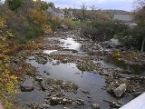
Bonnechere River
Encyclopedia
River
A river is a natural watercourse, usually freshwater, flowing towards an ocean, a lake, a sea, or another river. In a few cases, a river simply flows into the ground or dries up completely before reaching another body of water. Small rivers may also be called by several other names, including...
in the Saint Lawrence River
Saint Lawrence River
The Saint Lawrence is a large river flowing approximately from southwest to northeast in the middle latitudes of North America, connecting the Great Lakes with the Atlantic Ocean. It is the primary drainage conveyor of the Great Lakes Basin...
drainage basin
Drainage basin
A drainage basin is an extent or an area of land where surface water from rain and melting snow or ice converges to a single point, usually the exit of the basin, where the waters join another waterbody, such as a river, lake, reservoir, estuary, wetland, sea, or ocean...
in Nipissing District and Renfrew County in eastern
Eastern Ontario
Eastern Ontario is a subregion of Southern Ontario in the Canadian province of Ontario which lies in a wedge-shaped area between the Ottawa River and St. Lawrence River...
and northeastern
Northeastern Ontario
Northeastern Ontario is the region within the Canadian province of Ontario which lies north and east of Lakes Superior and Huron.Northeastern Ontario consists of the districts of Algoma, Sudbury, Cochrane, Timiskaming, Nipissing and Manitoulin; and the single-tier municipality of Greater...
Ontario
Ontario
Ontario is a province of Canada, located in east-central Canada. It is Canada's most populous province and second largest in total area. It is home to the nation's most populous city, Toronto, and the nation's capital, Ottawa....
, Canada
Canada
Canada is a North American country consisting of ten provinces and three territories. Located in the northern part of the continent, it extends from the Atlantic Ocean in the east to the Pacific Ocean in the west, and northward into the Arctic Ocean...
. The river flows from Algonquin Provincial Park
Algonquin Provincial Park
Algonquin Provincial Park is a provincial park located between Georgian Bay and the Ottawa River in Central Ontario, Canada, mostly within the Unorganized South Part of Nipissing District. Established in 1893, it is the oldest provincial park in Canada. Additions since its creation have increased...
to the Ottawa River
Ottawa River
The Ottawa River is a river in the Canadian provinces of Ontario and Quebec. For most of its length, it now defines the border between these two provinces.-Geography:...
east and north of the town of Renfrew
Renfrew, Ontario
Renfrew, Ontario, Canada, is a town on the Bonnechere River in Renfrew County. Located one hour west of Ottawa in Eastern Ontario, Renfrew is the third largest town in the county after Petawawa and Pembroke. The town is a small transportation hub connecting Ontario Highway 60 and Highway 132 with...
. The river's name is thought to come from the French
French language
French is a Romance language spoken as a first language in France, the Romandy region in Switzerland, Wallonia and Brussels in Belgium, Monaco, the regions of Quebec and Acadia in Canada, and by various communities elsewhere. Second-language speakers of French are distributed throughout many parts...
"bonne chère" meaning "good eating", which suggests that early explorers found an ample supply of game animals in this region.
Course
The Bonnechere River begins in Algonquin Provincial Park at McKaskill Lake in geographic Clancy Township in the Unorganized South Part of Nipissing District. It heads north into geographic Niven Township, then loops back southeast into Clancy Township, under a Hydro OneHydro One
Hydro One Incorporated delivers electricity across the Canadian province of Ontario. It is a Corporation established under the Business Corporations Act with a single shareholder, the Government of Ontario....
transmission corridor and into geographic Guthrie Township. It continues southeast through the Crooked Chute, over the High Falls, through the Stacks Rapids to the unincorporated place Basin Depot, located on a former logging road. The river continues southeast out of the park at Boundary access point (Access point Q), enters geographic Burns Township in Madawaska Valley
Madawaska Valley, Ontario
Madawaska Valley is a township in Renfrew County, Ontario, Canada. It was formed on January 1, 2001, through the amalgamation of the village of Barry's Bay and the townships of Radcliffe and Sherwood Jones & Burns....
, Renfrew County, then heads into geographic Richards Township in Killaloe, Hagarty and Richards
Killaloe, Hagarty and Richards, Ontario
Killaloe, Hagarty and Richards is an incorporated township in Renfrew County in eastern Ontario, Canada, created on July 1, 2000, as a result of an amalgamation of the Township of Hagarty and Richards with the Village of Killaloe.- Communities :* Bonnechere...
, Renfrew County, takes in the left tributary Pine River, passes through the Jack Chute Rapids, and reaches Round Lake
Round Lake (Ontario)
Round Lake is a lake located in Killaloe, Hagarty and Richards Township, Renfrew County, Ontario, Canada. The Bonnechere River flows into the lake in the northwest and flows out of the lake at the southeast....
, where it takes in the right tributary Sherwood River. The rivers leaves the lake at Grassy Bay controlled by the Round Lake Dam and reaches Golden Lake in North Algona Wilberforce, where it is crossed by Ontario Highway 60. The lake is home to Killaloe
Killaloe, Ontario
Killaloe is a town located in Renfrew County, Ontario, Canada in the township of Killaloe, Hagarty and Richards. Geographically it is located in Eastern Ontario. The shores of Golden Lake are located to the east, which is well known for quality angling and year round recreation...
at the west and the Algonquins of Pikwàkanagàn First Nation
Algonquins of Pikwàkanagàn First Nation
The Algonquins of Pikwàkanagàn First Nation, formerly known as the Golden Lake First Nation, are an Algonquin First Nation in Ontario, Canada...
at the southeast. From Golden Lake until the river reaches Admaston/Bromley downstream, the river forms the boundary between North Algona Wilberforce (left bank, on the north) and Bonnechere Valley
Bonnechere Valley, Ontario
Bonnechere Valley is a township in Renfrew County, Ontario, Canada. It had a population of 3,665 in the Canada 2006 Census.-Communities:The administrative and commercial centre of Bonnechere Valley is Eganville, a small community occupying a deep limestone valley carved at the Fifth Chute of the...
(right bank, on the south). The Bonnechere River leaves Golden Lake controlled by the Golden Lake Dam.
The river reaches its mouth at Lac des Chats
Lac des Chats
Lac des Chats is a lake on the Ottawa River that forms the boundary between the provinces of Ontario and Quebec . It is formed by the Chats Falls dam and serves as the reservoir for the Chats Falls generating station...
on the Ottawa River near the settlement of Fergusons Beach.
The river is 145 kilometres (90 mi) long and drains an area of 2400 square kilometres (927 sq mi).
Economy
During the 19th century, the river was used to transport white pineEastern White Pine
Pinus strobus, commonly known as the eastern white pine, is a large pine native to eastern North America, occurring from Newfoundland west to Minnesota and southeastern Manitoba, and south along the Appalachian Mountains to the northern edge of Georgia.It is occasionally known as simply white pine,...
logs from the forested areas surrounding the river. A number of hydroelectric plants have been built on the river.
Natural history
The Bonnechère Caves, formed from ancient limestone, are located by the river near the village of Eganville, OntarioEganville, Ontario
Eganville is a small community occupying a deep limestone valley carved at the Fifth Chute of the Bonnechere River in Renfrew County, Ontario, Canada. It is in the township of Bonnechere Valley. This village also has two of the most popular restaurants in the upper Ottawa Valley: The Granary and...
, in the hamlet of Fourth Chute, Ontario.
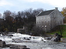
The First Chute (waterfall) of the river is where the Bonnechere empties into the Ottawa River, at Castleford. The Second Chute is in Renfrew; this waterfall has a small hydroelectric dam. The Third Chute is in Douglas, Ontario; it also has a small hydroelectric dam. The Fourth Chute is in the small village Fourth Chute, and the Fifth Chute is in Eganville, Ontario
Eganville, Ontario
Eganville is a small community occupying a deep limestone valley carved at the Fifth Chute of the Bonnechere River in Renfrew County, Ontario, Canada. It is in the township of Bonnechere Valley. This village also has two of the most popular restaurants in the upper Ottawa Valley: The Granary and...
.
There are two provincial parks along its length: the Bonnechere River Provincial Park (a 23 km long section bordering Algonquin Park) and the Bonnechere Provincial Park
Bonnechere Provincial Park
Bonnechere Provincial Park is an Ontario provincial park located on Round Lake in Renfrew County, Ontario, Canada.Designated as recreational-class by Ontario Parks, it has 128 campsites, 4 rustic cabins and a day use area, which includes a shower station, playground and a...
(located on Round Lake).
The Bonnechere River lies mostly in a 175 million year old rift valley
Rift valley
A rift valley is a linear-shaped lowland between highlands or mountain ranges created by the action of a geologic rift or fault. This action is manifest as crustal extension, a spreading apart of the surface which is subsequently further deepened by the forces of erosion...
called the Ottawa-Bonnechere Graben
Ottawa-Bonnechere Graben
The Ottawa-Bonnechere Graben , with its branch the Timiskaming Graben, is an ancient rift valley in the Canadian Shield of Northeastern Ontario and Quebec, Canada. This rift valley was formed when the Earth's crust moved downward about a kilometre between two major fault zones known as the Mattawa...
.
River run
Each year the river is host to a raft run between the third and fourth chute. Originally arranged by local ShrinersShriners
The Ancient Arabic Order of the Nobles of the Mystic Shrine, also commonly known as Shriners and abbreviated A.A.O.N.M.S., established in 1870, is an appendant body to Freemasonry, based in the United States...
the run has taken on a less official status, occurring with little to no organization apart from its pre-determined date during Victoria Day
Victoria Day
Victoria Day is a federal Canadian public holiday celebrated on the last Monday before May 25, in honour of Queen Victoria's birthday. The date is also, simultaneously, that on which the current reigning Canadian sovereign's official birthday is recognized...
weekend. Participants design and build a raft or anything else they hope will take them down the river. The river presents natural obstacles in the form of light rapids. There is no competitive angle to the run with no prize at the end other than warmth and a good time. Most participants are young adults from the area returning to visit friends and family. Having recently surpassed its tenth year, the river run is quickly becoming a local tradition.
Tributaries
- Golden Lake
- Scharfe Creek (left)
- Eadys Creek (left)
- Beaudrys Creek (left)
- Browns Creek (left)
- Sauers Creek (left)
- Cochrane Creek (left)
- Brennans Creek (right)
- Round Lake
- Turners Creek (left)
- Reserve Creek (left)
- Jacks Creek (left)
- Sherwood River (right)
- Byers Creek (right)
- Pine River (left)
- Robitaille Creek (right)
- Dupuis Creek (left)
- Hogan Creek (right)
- Jenkins Creek (left)
- Batise Creek (left)
- Gross Creek (left)
- McGuire Creek (right)
- North Bonnechere River (left)
- Fairy Creek (left)