
Bitterroot Mountains
Overview
- This article is about the Bitterroot Mountains, a subrange of the larger Bitterroot RangeBitterroot RangeThe Bitterroot Range runs along the border of Montana and Idaho in the northwestern United States. The range spans an area of 62,736 square kilometers and is named after the bitterroot , a small pink flower that is the state flower of Montana.- History :In 1805, the Corps of Discovery,...
.
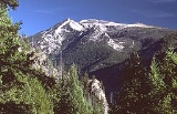
The Northern and Central Bitterroot Range, collectively the Bitterroot Mountains, is the largest portion of the Bitterroot Range
Bitterroot Range
The Bitterroot Range runs along the border of Montana and Idaho in the northwestern United States. The range spans an area of 62,736 square kilometers and is named after the bitterroot , a small pink flower that is the state flower of Montana.- History :In 1805, the Corps of Discovery,...
, part of the Rocky Mountains
Rocky Mountains
The Rocky Mountains are a major mountain range in western North America. The Rocky Mountains stretch more than from the northernmost part of British Columbia, in western Canada, to New Mexico, in the southwestern United States...
, located in the panhandle of
Idaho Panhandle
The Idaho Panhandle is the northern region of the U.S. State of Idaho that encompasses the ten northernmost counties of Benewah, Bonner, Boundary, Clearwater, Idaho, Kootenai, Latah, Lewis, Nez Perce, Shoshone. Residents of the panhandle refer to the region as North Idaho...
Idaho
Idaho
Idaho is a state in the Rocky Mountain area of the United States. The state's largest city and capital is Boise. Residents are called "Idahoans". Idaho was admitted to the Union on July 3, 1890, as the 43rd state....
and westernmost
Western Montana
Western Montana is the western region of the state of Montana, United States. Although there is no firm definition, Western Montana is roughly considered by some the western third of the state.-Geography, Biomes and Climate:...
Montana
Montana
Montana is a state in the Western United States. The western third of Montana contains numerous mountain ranges. Smaller, "island ranges" are found in the central third of the state, for a total of 77 named ranges of the Rocky Mountains. This geographical fact is reflected in the state's name,...
in the Western
Western United States
.The Western United States, commonly referred to as the American West or simply "the West," traditionally refers to the region comprising the westernmost states of the United States. Because the U.S. expanded westward after its founding, the meaning of the West has evolved over time...
United States
United States
The United States of America is a federal constitutional republic comprising fifty states and a federal district...
. The mountains encompass an area of 4,862 square miles (12,593 km²).
The mountains are bordered on the north by Lolo Creek, to the northeast by the Clark Fork
Clark Fork (river)
The Clark Fork is a river in the U.S. states of Montana and Idaho, approximately long. The largest river by volume in Montana, it drains an extensive region of the Rocky Mountains in western Montana and northern Idaho in the watershed of the Columbia River, flowing northwest through a long...
, on the south by the Salmon River
Salmon River (Idaho)
The Salmon River is located in Idaho in the northwestern United States. The Salmon is also known as The River of No Return. It flows for through central Idaho, draining and dropping more than between its headwaters, near Galena Summit above the Sawtooth Valley in the Sawtooth National...
, on the east by the Bitterroot River
Bitterroot River
The Bitterroot River is a tributary of the Clark Fork River in southwestern Montana, USA. It runs for about 75 miles south-to-north through the Bitterroot Valley, from the confluence of its West and East forks near Conner to the Clark Fork near Missoula.Ravalli County and Missoula County...
and Valley
Bitterroot Valley
The Bitterroot Valley is located in southwestern Montana in the northwestern United States. It extends over 100 miles from remote Horse Creek Pass north to a point near the city of Missoula...
, and on the west by the Selway
Selway River
The Selway River is located in north central Idaho in the northwestern United States within the Selway-Bitterroot Wilderness. It is a tributary of the Middle Fork of the Clearwater River in the Clearwater National Forest...
and Lochsa
Lochsa River
The Lochsa River is located in the northwestern United States, in the mountains of north central Idaho. It is one of two primary tributaries of the Middle Fork of the Clearwater River in the Clearwater National Forest. Lochsa is a Nez Perce word meaning rough water.The Lochsa was included by the...
Rivers.
Unanswered Questions