
Birzebbuga
Encyclopedia
Seaside resort
A seaside resort is a resort, or resort town, located on the coast. Where a beach is the primary focus for tourists, it may be called a beach resort.- Overview :...
not far from Marsaxlokk in south-east Malta
Malta
Malta , officially known as the Republic of Malta , is a Southern European country consisting of an archipelago situated in the centre of the Mediterranean, south of Sicily, east of Tunisia and north of Libya, with Gibraltar to the west and Alexandria to the east.Malta covers just over in...
. It is approximately 8 miles from the City of Valletta. Popular among Maltese holiday-makers for decades, this village is perhaps best known for its important archaeological sites, especially Għar Dalam and "Borg in-Nadur" and a sandy beach commonly known as "Pretty Bay". The village name "Birżebbuġa", from the Maltese
Maltese language
Maltese is the national language of Malta, and a co-official language of the country alongside English,while also serving as an official language of the European Union, the only Semitic language so distinguished. Maltese is descended from Siculo-Arabic...
, means a "well of olives". Such linguistic evidence established early inhabitants were in the south of the island since the first millennium. The name also indicates climate and food.
Early history
Near the village of Birżebbuġa is Għar Dalam, meaning a dark cave.Għar Dalam Cave is a highly important site, as it was here that the earliest evidence of human presence on Malta was discovered. Artifacts date back to the Neolithic Period some 7,400 years ago. The display area consists of two parts: the cave and the museum, which exhibits a remarkable wealth of finds from animal bones to human artifacts. An overlaying river running at right angles formed the cave. It is some 144 metres deep, but only the first fifty metres are open to visitors.
The lowermost layers, more than 500,000 years old, contain the fossil bones of dwarf elephants, hippopotami, micro-mammals and birds. Above the pebble layer is the so-called ‘deer’ layer, dated to around 18,000 years ago. The top layer dates to less than 10,000 years and holds evidence of the first humans on the Island. Experts hold that these remains suggest that the Islands were once a land bridge to continental Europe.
Other remains include those of a prehistoric temple or settlement, Borġ-in-Nadur, which dates from the Bronze Age. The settlement was fortified with a large stone wall, still visible today.
These temple ruins are important because they reveal not only a four-apse temple (c.2000 BC), but an authentic, fortified Bronze Age domestic settlement. The remains of a large, defensive wall lie nearby, running across the head of a promontory between two valleys leading down to two bays. The wall was built facing inland. The village would have had the sea to its back. This logistic situation leads scholars to believe that the people living in the village were more afraid of being attacked by invaders by land rather than from the sea.
Traces of Bronze Age huts were discovered lying just behind the wall. The depth of the deposits was very shallow, covering the remains of the Temple Period. Archaeologists have found evidence that shows that the Neolithic population became extinct and the islands were uninhabited. Archaeologists think that this could have been due to no agricultural produce, civil warfare, or the Neolithic population being murdered by war-like tribes. Archaeologists have uncovered the remains of the three apses (semi-circular rooms) of the temple. Beyond the main entrance, there is a wide elliptical area about 25 m long and 15 m wide. Only the Trilithon Entrance remains. Visits to these sites can be arranged by appointment.
History
In addition to prehistoric sites, the town includes historical structures and remains that date back centuries, revealing changing peoples as the island went through different periods of domination by various political interests. Such structures include Ferretti Coastal Battery, and the Birżebbuġa entrenchments. These sites date back to the rule of the Italian Catholic Knights of St. John, or Order of Malta, from (1530-1798). Napoleon ejected the Order from Malta, and later the island came under Great Britain.Churches tell part of the history of the town:
- St George's Church (1575, reopened in 1683). In the earth nearby are traces of prehistoric cart ruts.
- the Chapel of the Good ShepherdGood ShepherdGood Shepherd may refer to:In Christianity:* The Good Shepherd , pericope found in John 10:1-21, and a popular image in which the Good Shepherd represents Jesus...
, - the Immaculate ConceptionImmaculate ConceptionThe Immaculate Conception of Mary is a dogma of the Roman Catholic Church, according to which the Virgin Mary was conceived without any stain of original sin. It is one of the four dogmata in Roman Catholic Mariology...
Church at Bengħisa (1822, enlarged in 1862), - the Holy FamilyHoly FamilyThe Holy Family consists of the Child Jesus, the Virgin Mary, and Saint Joseph.The Feast of the Holy Family is a liturgical celebration in the Roman Catholic Church in honor of Jesus of Nazareth, his mother, the Blessed Virgin Mary, and his foster father, Saint Joseph, as a family...
Chapel (1865), - the Chapel of Our Lady Help of ChristiansMary Help of ChristiansMary Help of Christians , is a Roman Catholic Marian devotion with a feast day celebrated on May 24. John Chrysostom was the first person to use this title in 345 as a devotion to the Virgin Mary....
(1839), private; - St Joseph’s Chapel (1871), private; and
- the Church of Our Lady of SorrowsOur Lady of SorrowsOur Lady of Sorrows , the Sorrowful Mother or Mother of Sorrows , and Our Lady of the Seven Sorrows or Our Lady of the Seven Dolours are names by which the Blessed Virgin Mary is referred to in relation to sorrows in her life...
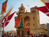
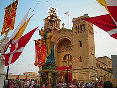
(1909), which served as parish church until 1938. Birżebbuġa became a formal parish on the 9th September 1913, with a resident priest. Some time later, the parish worked to build a larger church. St. Peter in Chains opened for worship on the 12th June 1938. The present parish priest is Rev. Fr Nicholas Pace.
During the last decade, there has been an influx of new workers employed at the nearby Malta Freeport and container terminal. In addition, new residents have come from the neighbouring villages, Birzebbuġa now hosts some 10,000 people.
The town is built around the beach, which puts it close to many shops and restaurants along the coastline. Some vacationers prefer the rocky shore in the neighbouring St George's Bay, ideal for sun bathing and snorkeling. Sailing is popular throughout the year. St George's Bay is also used by local fishermen who moor their boats at the inlet. St George's Bay is famous for its Cart Ruts that go across the small sandy Bay.
Before The No. 11 bus from City Gate to Valletta took approx 30 minutes, and the fare was quite cheap. Buses ran from the village to Valletta every 15 minutes. It costed exactly €0.47 each way
Now to go to Birzebbuga you will have to board either the 82 or X4 bus and buy a 2 hour ticket or a day ticket. The X4 passes every 30 minutes to Birzebbuga and 82 passes every 15 minutes.
Coat of arms
Birżebbuġa's coat of arms shows a blue chevron and olive branch on a white field. The blue represents the nearby waters of the Mediterranean SeaMediterranean Sea
The Mediterranean Sea is a sea connected to the Atlantic Ocean surrounded by the Mediterranean region and almost completely enclosed by land: on the north by Anatolia and Europe, on the south by North Africa, and on the east by the Levant...
and the olive branch the major importance of olives to the local economy, in former times.
Underwater Cart Ruts
Birzebbuga has Cart Ruts that lead into the sea and run along the sea floor.Sports
The locality hosts a number of football teams. Birzebbuga St. Peters F.C.Birzebbuga St. Peters F.C.
Birzebbuga St. Peters Football Club is a Maltese football club from the southern town of Birzebbuga, which currently plays in the Maltese First Division. They are the only football team from the town of Birzebbuga. They are known for producing young players from their Youth Nursery, which is called...
nowadays plays in the Maltese First Division
Maltese First Division
The Maltese First Division is the second-highest division in Maltese football, behind the Maltese Premier League and above the Maltese Second Division. The league has been running for many years.12 teams take part in the league...
after languishing at the bottom of Maltese football for years. As well as its Seniors' team, the club also possesses a prosperous nursery which is run by Birzebbuga Windmills FC. Birzebbuga St. Peters' is also in a collaboration with a newly-found futsal team, Birzebbuga St. Peters' FC Futsal, which is competing in the Maltese Futsal Fourth Division Section A as of 2011. Apart from these clubs, an amateur football team is also present, Birzebbuga Tigers FC.
Zones in Birżebbuġa
- Bengħisa
- Borġ in-NadurBorġ in-NadurBorġ in-Nadur is a Tarxien megalithic temple in open fields, overlooking St George’s Bay, near Birzebbuga, Malta. The site is now closed to the public and its preservation is the responsibility of Heritage Malta...
- Brolli
- Girgħien
- Għar Dalam
- Għar Ħasan, limits of Ħal Far
- Ħal Far
- Il-Gżira
- In-Nadur
- In-Nigret
- Kalafrana
- L-Arblu, limits of Ħal Far
- L-Artal, limits of Ħal Far
- L-Imwadar, limits of Bengħisa
- MaraMara-Social groups:*Mara people, in northeastern India and western Myanmar* Mara language, a language spoken by Mara people*Mara Salvatrucha, a violent criminal gang in Mexico, Central America, Canada, and the United States...
- Pretty Bay (Il-Bajja s-Sabiħa)
- Qajjenza
- St. George's Bay (Bajja San Ġorġ)
- Ta' Ġiliġejla, limits of Bengħisa
- Ta' Salvun, limits of Ħal Far
- Ta' Sansajna
- Ta' Żgħer, limits of Ħal Far
- Tal-Għawejra, limits of Ħal Far
- Tal-Papa
- Tax-Xerriek
- Wied Dalam
- Wied il-Buni
- Wied ix-Xoqqa, limits of Bengħisa
- Wied Qoton
- Wied Żembaq
- Wied Żnuber, limits of Ħal Far
- Xoqqiet, limits of Bengħisa