

Birstall, Leicestershire
Encyclopedia
Birstall is a large village and civil parish within the Charnwood borough of Leicestershire
, England
. It is three miles north of the Leicester
city centre and is part of the wider Leicester Urban Area
.
It is the largest village in Charnwood, with a population only marginally lower than the neighbouring town
of Syston
as of the 2001 Census.
. The village centre lies just off the A6, along Sibson Road. The village contains two supermarkets, a garden centre and a variety of other shops. There are a number of schools, including Highcliffe Primary School, Riverside Primary School, Stonehill High School, Longslade Community College
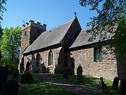
. The village contains the Anglican church of St. James the Great, the St Teresa Roman Catholic church and Birstall Methodist Church.
There is a large housing estate in the north-west of the village, built off of Greengate Lane. This is known unofficially as the Gates estate due to many of the road names ending in the word 'gate'. For example Ambergate Drive, Moorgate Avenue and Saltersgate Drive.
The Grand Union Canal
runs through the bottom end of the village, separating it from Watermead Country Park
, a series of lakes in the bottom of the Soar Valley
, which have been set aside as a recreational area and country park
.
The Great Central Railway
steam railway has its southern terminus near the village, where the A6 meets the Leicester outer ringroad at Red Hill Circle. The railway also forms the boundary of the southern end of Birstall Golf Club.
To the north of the village, the A6 meets the A46 Leicester Western Bypass and then continues on towards Loughborough
along the Soar Valley
, and so on to the North of England.
The symbol of Birstall is a Cedar tree. The original tree stands in Roman Road. It was once in the grounds of the now demolished Birstall Hall.
The local Air Training Corps unit is 1947(Birstall) Squadron.
Area of Parish: 791 acres (3.2 km²)
 The name Birstall comes from the Old English for "old disused fort" - Burhsteall.
Saxon
remnants have been found in the village and surrounding area. The village was called Burstalle in the Domesday Book
when it belonged to Hugh de Grandmesnil
. Willard held these lands for Hugh and the 16 acres (64,749.8 m²) of meadow and a mill were said to be worth three ounces of gold. The village was a small one until the arrival of the Great Central Railway
in 1899. From then onwards development has continued and still continues to-day. Between 1901 and the 2001 the population grew from 611 to over 11,000.
. As of April 2010 it had 11 streets. These are Archdale Close, Bridge Green, Dale Close, Far Pastures Road, Halfpenny Close, Hallam Fields Road, Little Connery Lees, Pinfold Close, Brook Furlong Drive, Palmer Square and Lady Augusta Road. North of the development, on the roundabout connecting the A46 and A6 is a new service area with a KFC
, a Shell
petrol station and an Etap Hotel
.
Shops:
Community facilities:
Parks:
Golf club:
Services 2 and Skylink
, Arriva Leicester Services 126/127, Paul S Winson Service X27, Centrebus
Services 70A/70B.
The Birstall park and ride operated by Roberts Tours
operates every 15 minutes Monday - Saturday daytime to Enderby (P&R)
and calls at; Belgrave Road (Golden Mile)
, Highcross Leicester, St Nicholas Circle (P&R hub)
and Fosse Park (Sainsburys)
, a smaller village, with the village of Rothley
being the next closest. The villages of Thurmaston
and Syston
are also nearby. Birstall shares its southern boundary with the city of Leicester
.
Leicestershire
Leicestershire is a landlocked county in the English Midlands. It takes its name from the heavily populated City of Leicester, traditionally its administrative centre, although the City of Leicester unitary authority is today administered separately from the rest of Leicestershire...
, England
England
England is a country that is part of the United Kingdom. It shares land borders with Scotland to the north and Wales to the west; the Irish Sea is to the north west, the Celtic Sea to the south west, with the North Sea to the east and the English Channel to the south separating it from continental...
. It is three miles north of the Leicester
Leicester
Leicester is a city and unitary authority in the East Midlands of England, and the county town of Leicestershire. The city lies on the River Soar and at the edge of the National Forest...
city centre and is part of the wider Leicester Urban Area
Leicester Urban Area
The Leicester Urban Area is a conurbation based around the city of Leicester in Leicestershire, England.While it has no formal definition as an administrative area, it is defined by the Office for National Statistics with a population of 441,213 at the time of the 2001 census...
.
It is the largest village in Charnwood, with a population only marginally lower than the neighbouring town
Town
A town is a human settlement larger than a village but smaller than a city. The size a settlement must be in order to be called a "town" varies considerably in different parts of the world, so that, for example, many American "small towns" seem to British people to be no more than villages, while...
of Syston
Syston
Syston is a town and civil parish in the district of Charnwood in Leicestershire, England. The population is 11,508 as of the 2001 Census.-Overview:...
as of the 2001 Census.
The Village
Birstall lies on the A6 and is the last major settlement before Leicester when arriving from the north. Birstall thus forms part of the Leicester Urban AreaLeicester Urban Area
The Leicester Urban Area is a conurbation based around the city of Leicester in Leicestershire, England.While it has no formal definition as an administrative area, it is defined by the Office for National Statistics with a population of 441,213 at the time of the 2001 census...
. The village centre lies just off the A6, along Sibson Road. The village contains two supermarkets, a garden centre and a variety of other shops. There are a number of schools, including Highcliffe Primary School, Riverside Primary School, Stonehill High School, Longslade Community College
Longslade Community College
Longslade Community College is a comprehensive school and Specialist Technology College in Birstall, a suburban village directly outside of Leicester city.-Admissions:...
. The village contains the Anglican church of St. James the Great, the St Teresa Roman Catholic church and Birstall Methodist Church.
There is a large housing estate in the north-west of the village, built off of Greengate Lane. This is known unofficially as the Gates estate due to many of the road names ending in the word 'gate'. For example Ambergate Drive, Moorgate Avenue and Saltersgate Drive.
The Grand Union Canal
Grand Union Canal
The Grand Union Canal in England is part of the British canal system. Its main line connects London and Birmingham, stretching for 137 miles with 166 locks...
runs through the bottom end of the village, separating it from Watermead Country Park
Watermead Country Park
The Watermead Country Park is a network of artificial lakes in the valley of the River Soar and the old Grand Union Canal, to the north of Leicester, in the Borough of Charnwood in Leicestershire. It runs north to south along the path of the watercourses, with Birstall to the west and Thurmaston...
, a series of lakes in the bottom of the Soar Valley
Soar Valley
The Soar Valley in Leicestershire, England is the basin of the River Soar, which rises south of Leicester and flows north through Charnwood before meeting the River Trent at Trent Lock on the Nottinghamshire border....
, which have been set aside as a recreational area and country park
Country park
A country park is an area designated for people to visit and enjoy recreation in a countryside environment.-History:In the United Kingdom the term 'Country Park' has a special meaning. There are over 400 Country Parks in England alone . Most Country Parks were designated in the 1970s, under the...
.
The Great Central Railway
Great Central Railway
The Great Central Railway was a railway company in England which came into being when the Manchester, Sheffield and Lincolnshire Railway changed its name in 1897 in anticipation of the opening in 1899 of its London Extension . On 1 January 1923, it was grouped into the London and North Eastern...
steam railway has its southern terminus near the village, where the A6 meets the Leicester outer ringroad at Red Hill Circle. The railway also forms the boundary of the southern end of Birstall Golf Club.
To the north of the village, the A6 meets the A46 Leicester Western Bypass and then continues on towards Loughborough
Loughborough
Loughborough is a town within the Charnwood borough of Leicestershire, England. It is the seat of Charnwood Borough Council and is home to Loughborough University...
along the Soar Valley
Soar Valley
The Soar Valley in Leicestershire, England is the basin of the River Soar, which rises south of Leicester and flows north through Charnwood before meeting the River Trent at Trent Lock on the Nottinghamshire border....
, and so on to the North of England.
The symbol of Birstall is a Cedar tree. The original tree stands in Roman Road. It was once in the grounds of the now demolished Birstall Hall.
The local Air Training Corps unit is 1947(Birstall) Squadron.
Area of Parish: 791 acres (3.2 km²)
History
Saxon
Anglo-Saxons
Anglo-Saxon is a term used by historians to designate the Germanic tribes who invaded and settled the south and east of Great Britain beginning in the early 5th century AD, and the period from their creation of the English nation to the Norman conquest. The Anglo-Saxon Era denotes the period of...
remnants have been found in the village and surrounding area. The village was called Burstalle in the Domesday Book
Domesday Book
Domesday Book , now held at The National Archives, Kew, Richmond upon Thames in South West London, is the record of the great survey of much of England and parts of Wales completed in 1086...
when it belonged to Hugh de Grandmesnil
Hugh de Grandmesnil
Hugh de Grandmesnil , also known as Hugh or Hugo de Grentmesnil or Grentemesnil, is one of the very few proven Companions of William the Conqueror known to have fought at the Battle of Hastings in 1066. Subsequently he became a great landowner in England.He was the elder son of Robert of...
. Willard held these lands for Hugh and the 16 acres (64,749.8 m²) of meadow and a mill were said to be worth three ounces of gold. The village was a small one until the arrival of the Great Central Railway
Great Central Railway
The Great Central Railway was a railway company in England which came into being when the Manchester, Sheffield and Lincolnshire Railway changed its name in 1897 in anticipation of the opening in 1899 of its London Extension . On 1 January 1923, it was grouped into the London and North Eastern...
in 1899. From then onwards development has continued and still continues to-day. Between 1901 and the 2001 the population grew from 611 to over 11,000.
Hallam Fields
A new housing development called 'Hallam Fields' commenced construction in 2006 and was well advanced as of 2008. It occupies land to the west of the A6, between the 'Gates' estate and the A46. The development will take ten years to complete, consisting of up to 900 properties including schools, shops, offices, industrial units and a fire station. It has been described as a mini PoundburyPoundbury
Poundbury is an experimental new town or urban extension on the outskirts of Dorchester in the county of Dorset, England.The development is built on land owned by the Duchy of Cornwall. It is built according to the principles of Prince Charles...
. As of April 2010 it had 11 streets. These are Archdale Close, Bridge Green, Dale Close, Far Pastures Road, Halfpenny Close, Hallam Fields Road, Little Connery Lees, Pinfold Close, Brook Furlong Drive, Palmer Square and Lady Augusta Road. North of the development, on the roundabout connecting the A46 and A6 is a new service area with a KFC
KFC
KFC, founded and also known as Kentucky Fried Chicken, is a chain of fast food restaurants based in Louisville, Kentucky, in the United States. KFC has been a brand and operating segment, termed a concept of Yum! Brands since 1997 when that company was spun off from PepsiCo as Tricon Global...
, a Shell
Royal Dutch Shell
Royal Dutch Shell plc , commonly known as Shell, is a global oil and gas company headquartered in The Hague, Netherlands and with its registered office in London, United Kingdom. It is the fifth-largest company in the world according to a composite measure by Forbes magazine and one of the six...
petrol station and an Etap Hotel
Etap Hotel
Etap is a European chain of basic-service budget hotels owned by the Accor Group. There are several branches in major cities and close to transport hubs like the Eurotunnel terminal in Coquelles. The chain competes with chains like Holiday Inn Express and Travelodge in Europe and the UK.-Rooms:The...
.
Places/buildings within the village
Schools:- Highcliffe primary school
- Riverside primary school
- Stonehill high schoolHigh schoolHigh school is a term used in parts of the English speaking world to describe institutions which provide all or part of secondary education. The term is often incorporated into the name of such institutions....
- Longslade Community CollegeLongslade Community CollegeLongslade Community College is a comprehensive school and Specialist Technology College in Birstall, a suburban village directly outside of Leicester city.-Admissions:...
Shops:
- Two main supermarkets -Co-operative on Wanlip Lane, Tesco Express on Sibson Road.
- One garden centreGarden centreA garden centre is a retail firm that sells plants and products related to gardens as its primary business. It is open to the public, with facilities to care for and display plants.- UK :...
- Various shops along Sibson road
Community facilities:
- Library on Wanlip Lane
- Parish Council offices
Parks:
- Watermead Country ParkWatermead Country ParkThe Watermead Country Park is a network of artificial lakes in the valley of the River Soar and the old Grand Union Canal, to the north of Leicester, in the Borough of Charnwood in Leicestershire. It runs north to south along the path of the watercourses, with Birstall to the west and Thurmaston...
- School Lane recreational park
- Harrogate park
Golf club:
- Birstall Golf Club - founded in 1901 - one of the first golf clubs in LeicestershireLeicestershireLeicestershire is a landlocked county in the English Midlands. It takes its name from the heavily populated City of Leicester, traditionally its administrative centre, although the City of Leicester unitary authority is today administered separately from the rest of Leicestershire...
Transport
The Village is served by KinchbusKinchbus
Kinchbus is a bus operator based in Loughborough. It was originally an independent company established by Gilbert Kinch, but is now owned by the Wellglade Group. It operates various local services around Loughborough, Route 2 from Leicester to Loughborough and Skylink from Derby to Loughborough...
Services 2 and Skylink
Skylink (bus routes)
Skylink is the name used for bus services operating from East Midlands Airport to Leicester and Derby via the airport operated by Kinchbus which operate every 30 minutes during the daytime and hourly during the evenings and early hours from Leicester, St Margaret's Bus Station to Derby Bus Station...
, Arriva Leicester Services 126/127, Paul S Winson Service X27, Centrebus
Centrebus
Centrebus is a privately owned company that operate a number of services around Leicester and Leicestershire, Grantham, Hertfordshire and Bedfordshire, mainly in areas where Arriva has scaled down its bus operations. Centrebus also competes with Arriva on some routes in Leicester, Luton and Stevenage...
Services 70A/70B.
The Birstall park and ride operated by Roberts Tours
Roberts Coaches
Roberts Coaches are an English public transport company, based in Hugglescote, Leicestershire.-Services:Roberts provide public bus services in Leicester and Leicestershire.-List of routes:...
operates every 15 minutes Monday - Saturday daytime to Enderby (P&R)
Enderby, Leicestershire
Enderby is a civil parish in the district of Blaby , in Leicestershire, England. It is situated on the south western outskirts of the city of Leicester and has a population of 5,648 at the time of the 2001 census....
and calls at; Belgrave Road (Golden Mile)
Golden Mile
There are many geographical features called the "Golden Mile":* The Golden Mile, Belfast, Northern Ireland, United Kingdom * The Golden Mile, Blackpool, UK* The Golden Mile, Brentford, UK* The Golden Mile, Great Yarmouth, UK* The Golden Mile, Leicester, UK...
, Highcross Leicester, St Nicholas Circle (P&R hub)
Leicester City Centre
Leicester City Centre is an area covering the core inner city area and central business district of the city of Leicester, England. It is roughly delineated from Leicester's suburbs by the A594, Leicester's inner ring road....
and Fosse Park (Sainsburys)
Neighbouring villages
The closest village to Birstall is WanlipWanlip
Wanlip is a small village and civil parish in the Charnwood district of Leicestershire, with 68 properties and a population of about 150. It is a countryside village, north of Birstall, and west of Watermead Country Park and the River Soar. The A46 road runs directly past the village...
, a smaller village, with the village of Rothley
Rothley, Leicestershire
Rothley is a village and civil parish within the Charnwood borough of Leicestershire, England. Situated around west of the River Soar and north of the city of Leicester, it has a population of 3,612 inhabitants....
being the next closest. The villages of Thurmaston
Thurmaston
Thurmaston is a village and civil parish within the Charnwood borough of Leicestershire, England. As of the 2001 census its population was 8,945...
and Syston
Syston
Syston is a town and civil parish in the district of Charnwood in Leicestershire, England. The population is 11,508 as of the 2001 Census.-Overview:...
are also nearby. Birstall shares its southern boundary with the city of Leicester
Leicester
Leicester is a city and unitary authority in the East Midlands of England, and the county town of Leicestershire. The city lies on the River Soar and at the edge of the National Forest...
.