
Birmingham Tornado of April 1998
Encyclopedia
The Birmingham Tornado was a tornadic event that occurred on April 8, 1998 striking the western part of Jefferson County, Alabama
, near Birmingham
, and continuing into neighboring St. Clair County
. It was part of a larger outbreak that started on April 6 across the Great Plains
and ended on April 9 across the Carolinas and Georgia. A total of 62 tornadoes touched down from the Middle Atlantic States to the Midwestern United States
and Texas
. The Birmingham Tornado was one of only two F5 tornadoes that year. The other hit in Lawrence County, Tennessee on April 16, as part of the same outbreak as the Nashville tornadoes. The tornado outbreak was responsible for at least 41 deaths including 7 in Georgia
and 34 in Alabama
.

and Tuscaloosa Counties
. It produced an F3 and traveled north of the city of Tuscaloosa
. Two injuries were reported and five homes and 11 mobile homes were destroyed from this storm that traveled over 17 miles (27 km) from Holman to north of Northport
. 24 homes and 13 mobile homes were also damaged.http://www4.ncdc.noaa.gov/cgi-win/wwcgi.dll?wwevent~ShowEv
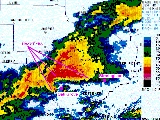
 Shortly after 7:30 P.M., the supercell
spawned the Birmingham Tornado as a wall cloud
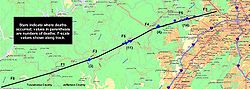
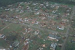
. It touched down in extreme eastern Tuscaloosa County and then cut a 31-mile long (49 km), 3/4-mile wide swath through nine Birmingham suburbs with F3 to F5 damage including Oak Grove, Sylvan Springs
, Rock Creek
, Pleasant Grove
, Concord
, Maytown
, and Edgewater
before lifting in the western limits of the City of Birmingham just northwest of the junctions of Interstates 20
, 59
and 65
. The worst of the destruction occurred across the Oak Grove, Rock Creek and McDonald Chapel
areas. The second area affected by F5 damage was also devastated by a violent tornado in 1956 that tracked through the same areas hit by this storm. http://www.tornadoproject.com/past/othralts.htm#top
 Thirty-two people were killed in this tornado including three in Oak Grove, eleven near Rock Creek, four in Sylvan Springs, two in Wylam Heights, nine in Edgewater, two in McDonald Chapel and one in West Ensley.http://www4.ncdc.noaa.gov/cgi-win/wwcgi.dll?wwevent~ShowEvent~315723 One young boy died nine days after this event from head injuries. His father was paralyzed from the waist down, and his mother suffered severe injuries. Another mother and her two children were killed when hundreds of pounds of debris was blown onto them.
Oak Grove, an unincorporated community west of Hueytown
, was one of the hardest hit locations. Oak Grove High School was damaged beyond repair with the elementary school portion destroyed, but they were rebuilt two years later and reopened a mile away from the damaged area. The Oak Grove fire station was heavily damaged as well. No one inside the school was killed but a group of cheerleaders practicing at the school's gymnasium escaped disaster with only minor injuries when a wall prevented a portion of the roof from falling on them. http://www.lindleyonline.com/tornado.htm
The roofs of Hueytown's Rock Creek Church of God were blown off and several cars were blown 500 feet into a ravine. The church was turned into a trauma center
. The United Methodist churches of Sylvan Springs, Edgewater, and McDonald Chapel were totally damaged by the windstorm. Open Door Church also sustained heavy damage as well, with several members having to take shelter in hallways.
Had the storm remained on the ground, it would have gone into the northern sections of downtown Birmingham. A few miles further to the east, the Birmingham International Airport could have been affected as well. The storm lifted before reaching these sections of Birmingham. However, it touched down again in neighboring St. Clair County
, where two people were killed.
Debris from the tornado was scattered across central Alabama as far north as sections of Blount County
.
The tornado was the seventh deadliest in Alabama
history, killing one more person than in a tornado that hit Alabama on March 21, 1932.
The tornado's effects were noticed around the same time by the ABC 33/40
Birmingham tower camera
, which was pointed toward the western suburbs. Though it was dark, a massive power failure occurred in western Birmingham, when several transmission lines coming from the Miller Steam Plant electric generating station were knocked off line. This was noticed during the long-form weather coverage on 33/40, which lasted most of the evening. (The station, and several of its competitors, has a policy of pre-empting regular programming and broadcasting only severe weather information when a tornado warning
is in effect for any part of its coverage area.)
just before 9:00 PM CDT killing 2 who were inside a mobile home when the tornado hit. It remained over rural areas for 14 miles (22 km) but the F2 partially destroyed Bethel Baptist Church in Odenville
, 26 homes and mobile homes and other buildings in the Coal City area. About 90 other homes and mobile homes suffered minor to major damage. An additional 12 people were injured in this storm. http://www4.ncdc.noaa.gov/cgi-win/wwcgi.dll?wwevent~ShowEvent~315749
As the bulk of the activity exited Alabama, the severe weather reached the Atlanta
metropolitan area late during the evening. Two tornadoes both rated F2 touched down in the northern suburbs of Atlanta. One of the tornadoes killed one person in DeKalb County
. Activity persisted through the early hours of April 9 where two more killer tornadoes touched down west of Savannah
. An F3 tornado near Blitchton in Bryan County
killed two people and injured 15 others while damaging or destroying nearly 90 homes. An F2 tornado further south in Long
and Liberty Counties
killed 4 including 3 mobile home occupants in Rye Patch and one soldier at Fort Stewart
Army Base.
Other tornadoes touched down on April 9 between Cleveland
and Pittsburgh while several tornadoes touched down across southern Illinois on April 7 but without additional fatalities.
Jefferson County, Alabama
Jefferson County is the most populous county in the U.S. state of Alabama, with its county seat being located in Birmingham.As of the 2010 U.S. Census, the population of Jefferson County was 658,466...
, near Birmingham
Birmingham, Alabama
Birmingham is the largest city in Alabama. The city is the county seat of Jefferson County. According to the 2010 United States Census, Birmingham had a population of 212,237. The Birmingham-Hoover Metropolitan Area, in estimate by the U.S...
, and continuing into neighboring St. Clair County
St. Clair County, Alabama
St. Clair County is a county of the U.S. state of Alabama.It is a part of the Birmingham–Hoover–Cullman Combined Statistical Area. Its name is in honor of General Arthur St...
. It was part of a larger outbreak that started on April 6 across the Great Plains
Great Plains
The Great Plains are a broad expanse of flat land, much of it covered in prairie, steppe and grassland, which lies west of the Mississippi River and east of the Rocky Mountains in the United States and Canada. This area covers parts of the U.S...
and ended on April 9 across the Carolinas and Georgia. A total of 62 tornadoes touched down from the Middle Atlantic States to the Midwestern United States
United States
The United States of America is a federal constitutional republic comprising fifty states and a federal district...
and Texas
Texas
Texas is the second largest U.S. state by both area and population, and the largest state by area in the contiguous United States.The name, based on the Caddo word "Tejas" meaning "friends" or "allies", was applied by the Spanish to the Caddo themselves and to the region of their settlement in...
. The Birmingham Tornado was one of only two F5 tornadoes that year. The other hit in Lawrence County, Tennessee on April 16, as part of the same outbreak as the Nashville tornadoes. The tornado outbreak was responsible for at least 41 deaths including 7 in Georgia
Georgia (U.S. state)
Georgia is a state located in the southeastern United States. It was established in 1732, the last of the original Thirteen Colonies. The state is named after King George II of Great Britain. Georgia was the fourth state to ratify the United States Constitution, on January 2, 1788...
and 34 in Alabama
Alabama
Alabama is a state located in the southeastern region of the United States. It is bordered by Tennessee to the north, Georgia to the east, Florida and the Gulf of Mexico to the south, and Mississippi to the west. Alabama ranks 30th in total land area and ranks second in the size of its inland...
.
Birmingham supercell
Tuscaloosa County tornado (F3)
The worst of the outbreak started around 7:00 PM CDT when a supercell originating from Mississippi entered PickensPickens County, Alabama
Pickens County is a county of the U.S. state of Alabama. As of 2010, the population was 19,746. Its county seat is Carrollton, and it is a prohibition, or dry county.-History:...
and Tuscaloosa Counties
Tuscaloosa County, Alabama
Tuscaloosa County is a county of the U.S. state of Alabama.It is named in honor of the pre-Choctaw chief Tuskaloosa. In 2010, the population was 194,656...
. It produced an F3 and traveled north of the city of Tuscaloosa
Tuscaloosa, Alabama
Tuscaloosa is a city in and the seat of Tuscaloosa County in west central Alabama . Located on the Black Warrior River, it is the fifth-largest city in Alabama, with a population of 90,468 in 2010...
. Two injuries were reported and five homes and 11 mobile homes were destroyed from this storm that traveled over 17 miles (27 km) from Holman to north of Northport
Northport, Alabama
Northport is a city in Tuscaloosa County in the west central part of the U.S. state of Alabama. Located on the Black Warrior River across from downtown Tuscaloosa, it is currently the 24th largest city in Alabama with an estimated population of 23,442 in 2009...
. 24 homes and 13 mobile homes were also damaged.http://www4.ncdc.noaa.gov/cgi-win/wwcgi.dll?wwevent~ShowEv
Jefferson County tornado (F5)
Supercell
A supercell is a thunderstorm that is characterized by the presence of a mesocyclone: a deep, continuously-rotating updraft. For this reason, these storms are sometimes referred to as rotating thunderstorms...
spawned the Birmingham Tornado as a wall cloud
Wall cloud
A wall cloud is a large, lowering, and rotating base of a cumulonimbus cloud that potentially forms tornadoes. It is typically beneath the rain-free base portion of a deep cumulus cloud , and indicates the area of primary and strongest updraft which condenses into cloud at altitudes lower than...
. It touched down in extreme eastern Tuscaloosa County and then cut a 31-mile long (49 km), 3/4-mile wide swath through nine Birmingham suburbs with F3 to F5 damage including Oak Grove, Sylvan Springs
Sylvan Springs, Alabama
Sylvan Springs is a town in Jefferson County, Alabama, United States. It is part of the Birmingham–Hoover–Cullman Combined Statistical Area. At the 2000 census the population was 1,465...
, Rock Creek
Rock Creek, Alabama
Rock Creek is a census-designated place in Jefferson County, Alabama, United States. It is part of the Birmingham–Hoover–Cullman Combined Statistical Area. At the 2000 census the population was 1,495. This area was damaged by an F5 tornado on April 8, 1998 including Hueytown's Rock Creek Church of...
, Pleasant Grove
Pleasant Grove, Alabama
Pleasant Grove is a city in Jefferson County, Alabama and suburb of Birmingham. It is part of the Birmingham–Hoover Metropolitan Area. Its nickname is "The Good Neighbor City". At the 2010 census the population was 10,110.-History:...
, Concord
Concord, Alabama
Concord is a census-designated place in Jefferson County, Alabama, United States. It is part of the Birmingham–Hoover–Cullman Combined Statistical Area. At the 2000 census the population was 1,809. This area was damaged by an F5 tornado on April 8, 1998, and again by an EF4 tornado on Wednesday,...
, Maytown
Maytown, Alabama
Maytown is a town in Jefferson, Alabama, United States. It is part of the Birmingham–Hoover–Cullman Combined Statistical Area. At the 2000 census the population was 435. This area was damaged by an F5 tornado on April 8, 1998.-Geography:...
, and Edgewater
Edgewater, Alabama
Edgewater is a census-designated place in Birmingham, Alabama, United States northeast of Pleasant Grove. Its population was 730 at the 2000 census. This area was damaged by tornadoes on April 15, 1956 and April 8, 1998. The 1998 tornado was rated an F5 on the Fujita scale. -Geography:Edgewater is...
before lifting in the western limits of the City of Birmingham just northwest of the junctions of Interstates 20
Interstate 20
Interstate 20 is a major east–west Interstate Highway in the Southern United States. I‑20 runs 1,535 miles from near Kent, Texas, at Interstate 10 to Florence, South Carolina, at Interstate 95...
, 59
Interstate 59
Interstate 59 is an Interstate Highway in the southern United States. Its southern terminus is near Slidell, Louisiana, a suburb of New Orleans, at an intersection with Interstate 10 and Interstate 12, its northern terminus is at Wildwood, Georgia, at an intersection with Interstate 24.The road's...
and 65
Interstate 65
Interstate 65 is a major Interstate Highway in the United States. The southern terminus is located at an intersection with Interstate 10 in Mobile, Alabama, and its northern terminus is at an interchange with Interstate 90 , U.S. Route 12, and U.S...
. The worst of the destruction occurred across the Oak Grove, Rock Creek and McDonald Chapel
McDonald Chapel, Alabama
McDonald Chapel is a census-designated place in Birmingham, Alabama, United States northeast of Pleasant Grove. At the 2000 census the population was 1,054. Large portions of this area were damaged by violent tornadoes in 1956, 1998, and 2011. The 1998 tornado was rated an F5 on the Fujita scale....
areas. The second area affected by F5 damage was also devastated by a violent tornado in 1956 that tracked through the same areas hit by this storm. http://www.tornadoproject.com/past/othralts.htm#top
Oak Grove, an unincorporated community west of Hueytown
Hueytown, Alabama
Hueytown is a city in Jefferson County, Alabama, United States. At the 2010 census the population was 16,105.It was the home of the legendary NASCAR Alabama Gang...
, was one of the hardest hit locations. Oak Grove High School was damaged beyond repair with the elementary school portion destroyed, but they were rebuilt two years later and reopened a mile away from the damaged area. The Oak Grove fire station was heavily damaged as well. No one inside the school was killed but a group of cheerleaders practicing at the school's gymnasium escaped disaster with only minor injuries when a wall prevented a portion of the roof from falling on them. http://www.lindleyonline.com/tornado.htm
The roofs of Hueytown's Rock Creek Church of God were blown off and several cars were blown 500 feet into a ravine. The church was turned into a trauma center
Trauma center
A trauma center is a hospital equipped to provide comprehensive emergency medical services to patients suffering traumatic injuries. Trauma centers grew into existence out of the realization that traumatic injury is a disease process unto itself requiring specialized and experienced...
. The United Methodist churches of Sylvan Springs, Edgewater, and McDonald Chapel were totally damaged by the windstorm. Open Door Church also sustained heavy damage as well, with several members having to take shelter in hallways.
Had the storm remained on the ground, it would have gone into the northern sections of downtown Birmingham. A few miles further to the east, the Birmingham International Airport could have been affected as well. The storm lifted before reaching these sections of Birmingham. However, it touched down again in neighboring St. Clair County
St. Clair County, Alabama
St. Clair County is a county of the U.S. state of Alabama.It is a part of the Birmingham–Hoover–Cullman Combined Statistical Area. Its name is in honor of General Arthur St...
, where two people were killed.
Debris from the tornado was scattered across central Alabama as far north as sections of Blount County
Blount County, Alabama
Blount County is a county located in the U.S. state of Alabama. As of the 2010 United States Census, the population was 57,322. Its county seat is Oneonta.Blount County is a dry county.-History:...
.
The tornado was the seventh deadliest in Alabama
Alabama
Alabama is a state located in the southeastern region of the United States. It is bordered by Tennessee to the north, Georgia to the east, Florida and the Gulf of Mexico to the south, and Mississippi to the west. Alabama ranks 30th in total land area and ranks second in the size of its inland...
history, killing one more person than in a tornado that hit Alabama on March 21, 1932.
The tornado's effects were noticed around the same time by the ABC 33/40
WBMA-LP
WBMA-LD, channel 58, is the ABC television affiliate for Birmingham and central Alabama. Its transmitter is located in Birmingham, while its studio is in Hoover, a suburb of Birmingham....
Birmingham tower camera
Camera
A camera is a device that records and stores images. These images may be still photographs or moving images such as videos or movies. The term camera comes from the camera obscura , an early mechanism for projecting images...
, which was pointed toward the western suburbs. Though it was dark, a massive power failure occurred in western Birmingham, when several transmission lines coming from the Miller Steam Plant electric generating station were knocked off line. This was noticed during the long-form weather coverage on 33/40, which lasted most of the evening. (The station, and several of its competitors, has a policy of pre-empting regular programming and broadcasting only severe weather information when a tornado warning
Tornado warning
A tornado warning is an alert issued by government weather services to warn that severe thunderstorms with tornadoes may be imminent. It can be issued after a tornado or funnel cloud has been spotted by eye, or more commonly if there are radar indications of tornado formation...
is in effect for any part of its coverage area.)
St. Clair County tornado (F2)
After crossing the northern suburbs of Birmingham, the supercell dropped another tornado in St. Clair County near Pell CityPell City, Alabama
Pell City is a city in St. Clair County, Alabama, United States. The city is the county seat of St. Clair County along with Ashville. At the 2000 census the population was 9,565. At the 2010 census, the city-limit population jumped to 12,695. -Geography:...
just before 9:00 PM CDT killing 2 who were inside a mobile home when the tornado hit. It remained over rural areas for 14 miles (22 km) but the F2 partially destroyed Bethel Baptist Church in Odenville
Odenville, Alabama
Odenville is a town in St. Clair County, Alabama, United States. At the 2000 census the population was 1,131.-Geography:Odenville is located at .According to the U.S. Census Bureau, the town has a total area of , all of it land....
, 26 homes and mobile homes and other buildings in the Coal City area. About 90 other homes and mobile homes suffered minor to major damage. An additional 12 people were injured in this storm. http://www4.ncdc.noaa.gov/cgi-win/wwcgi.dll?wwevent~ShowEvent~315749
Georgia tornadoes
| State | Total | County | County total |
|---|---|---|---|
| Alabama Alabama Alabama is a state located in the southeastern region of the United States. It is bordered by Tennessee to the north, Georgia to the east, Florida and the Gulf of Mexico to the south, and Mississippi to the west. Alabama ranks 30th in total land area and ranks second in the size of its inland... |
34 | Jefferson Jefferson County, Alabama Jefferson County is the most populous county in the U.S. state of Alabama, with its county seat being located in Birmingham.As of the 2010 U.S. Census, the population of Jefferson County was 658,466... |
32 |
| St. Clair St. Clair County, Alabama St. Clair County is a county of the U.S. state of Alabama.It is a part of the Birmingham–Hoover–Cullman Combined Statistical Area. Its name is in honor of General Arthur St... |
2 | ||
| Georgia Georgia (U.S. state) Georgia is a state located in the southeastern United States. It was established in 1732, the last of the original Thirteen Colonies. The state is named after King George II of Great Britain. Georgia was the fourth state to ratify the United States Constitution, on January 2, 1788... |
7 | Bryan Bryan County, Georgia Bryan County is a county located in the U.S. state of Georgia. As of 2000, the population was 23,417. The 2007 Census Estimate shows a population of 30,132... |
2 |
| De Kalb | 1 | ||
| Liberty Liberty County, Georgia Liberty County is a county located in the U.S. state of Georgia. As of 2000, the population was 61,610. The 2007 Census Estimate shows a population of 60,503... |
1 | ||
| Long Long County, Georgia Long County is a county located in the U.S. state of Georgia. The constitutional amendment to create the county was proposed August 14, 1920, and ratified November 2, 1920. As of 2000, the population is 10,304. The 2007 Census Estimate shows a population of 11,300... |
3 | ||
| Totals | 41 | ||
| All deaths were tornado-related | |||
As the bulk of the activity exited Alabama, the severe weather reached the Atlanta
Atlanta, Georgia
Atlanta is the capital and most populous city in the U.S. state of Georgia. According to the 2010 census, Atlanta's population is 420,003. Atlanta is the cultural and economic center of the Atlanta metropolitan area, which is home to 5,268,860 people and is the ninth largest metropolitan area in...
metropolitan area late during the evening. Two tornadoes both rated F2 touched down in the northern suburbs of Atlanta. One of the tornadoes killed one person in DeKalb County
DeKalb County, Georgia
DeKalb County is a county located in the U.S. state of Georgia. The population of the county was 691,893 at the 2010 census. Its county seat is the city of Decatur. It is bordered to the west by Fulton County and contains roughly 10% of the city of Atlanta...
. Activity persisted through the early hours of April 9 where two more killer tornadoes touched down west of Savannah
Savannah, Georgia
Savannah is the largest city and the county seat of Chatham County, in the U.S. state of Georgia. Established in 1733, the city of Savannah was the colonial capital of the Province of Georgia and later the first state capital of Georgia. Today Savannah is an industrial center and an important...
. An F3 tornado near Blitchton in Bryan County
Bryan County, Georgia
Bryan County is a county located in the U.S. state of Georgia. As of 2000, the population was 23,417. The 2007 Census Estimate shows a population of 30,132...
killed two people and injured 15 others while damaging or destroying nearly 90 homes. An F2 tornado further south in Long
Long County, Georgia
Long County is a county located in the U.S. state of Georgia. The constitutional amendment to create the county was proposed August 14, 1920, and ratified November 2, 1920. As of 2000, the population is 10,304. The 2007 Census Estimate shows a population of 11,300...
and Liberty Counties
Liberty County, Georgia
Liberty County is a county located in the U.S. state of Georgia. As of 2000, the population was 61,610. The 2007 Census Estimate shows a population of 60,503...
killed 4 including 3 mobile home occupants in Rye Patch and one soldier at Fort Stewart
Fort Stewart
Fort Stewart is a census-designated place and U.S. Army post primarily in Liberty County and Bryan County, but also extending into smaller portions of Evans, Long, and Tattnall Counties in Georgia, USA. The population was 11,205 at the 2000 census...
Army Base.
Other tornadoes touched down on April 9 between Cleveland
Cleveland, Ohio
Cleveland is a city in the U.S. state of Ohio and is the county seat of Cuyahoga County, the most populous county in the state. The city is located in northeastern Ohio on the southern shore of Lake Erie, approximately west of the Pennsylvania border...
and Pittsburgh while several tornadoes touched down across southern Illinois on April 7 but without additional fatalities.
April 6 event
| F# Fujita scale The Fujita scale , or Fujita-Pearson scale, is a scale for rating tornado intensity, based primarily on the damage tornadoes inflict on human-built structures and vegetation... |
Location | County | Time (UTC) | Path length | Damage | |
|---|---|---|---|---|---|---|
| Texas Texas Texas is the second largest U.S. state by both area and population, and the largest state by area in the contiguous United States.The name, based on the Caddo word "Tejas" meaning "friends" or "allies", was applied by the Spanish to the Caddo themselves and to the region of their settlement in... |
||||||
| F0 | N of Elliott | Wilbarger Wilbarger County, Texas *Harrold *Odell *Oklaunion *Vernon-Notable natives and residents:*Jack English Hightower, Memphis, Texas, native; former member of both houses of the Texas State Legislature, and former U.S... |
2313 | 0.1 miles (0.16 km) |
Brief touchdown in a field | |
| Iowa Iowa Iowa is a state located in the Midwestern United States, an area often referred to as the "American Heartland". It derives its name from the Ioway people, one of the many American Indian tribes that occupied the state at the time of European exploration. Iowa was a part of the French colony of New... |
||||||
| F0 | NE of Adaza | Greene Greene County, Iowa -2010 census:The 2010 census recorded a population of 9,336 in the county, with a population density of . There were 4,546 housing units, of which 3,996 were occupied.-2000 census:... |
2315 | 0.2 miles (0.32 km) |
Brief touchdown with no damage | |
| F0 | S of Dayton Dayton, Iowa Dayton is a city in Webster County, Iowa, United States. The population was 884 at the 2000 census.-Geography:Dayton is located at .According to the United States Census Bureau, the city has a total area of , all of it land.... |
Webster Webster County, Iowa -2010 census:The 2010 census recorded a population of 38,013 in the county, with a population density of . There were 17,035 housing units, of which 15,580 were occupied.-2000 census:... |
2355 | 0.1 miles (0.16 km) |
Brief touchdown with no damage | |
| F0 | NE of Ralston Ralston, Iowa Ralston is a city in Carroll and Greene Counties in the U.S. state of Iowa. The population was 98 at the 2000 census.-Geography:Ralston is located at .... |
Greene Greene County, Iowa -2010 census:The 2010 census recorded a population of 9,336 in the county, with a population density of . There were 4,546 housing units, of which 3,996 were occupied.-2000 census:... |
0000 | 0.2 miles (0.32 km) |
Brief touchdown with no damage | |
| Kansas Kansas Kansas is a US state located in the Midwestern United States. It is named after the Kansas River which flows through it, which in turn was named after the Kansa Native American tribe, which inhabited the area. The tribe's name is often said to mean "people of the wind" or "people of the south... |
||||||
| F1 | E of Schoenchen Schoenchen, Kansas Schoenchen is a city in Ellis County, Kansas, United States. As of the 2010 census, the city population was 207.-History:Following a dispute over the proposed relocation of nearby Liebenthal, Volga German settlers founded Schoenchen in April 1877. They originally named the community San Antonio,... |
Ellis Ellis County, Kansas Ellis County is a county located in Northwest Kansas, in the Central United States. As of the 2010 census, the county population was 28,452. Its county seat and most populous city is Hays... |
2325 | 3.3 miles (5.3 km) |
Damage to a metal building, a chicken house and a quonset hut. 2 people were injured | |
| Oklahoma Oklahoma Oklahoma is a state located in the South Central region of the United States of America. With an estimated 3,751,351 residents as of the 2010 census and a land area of 68,667 square miles , Oklahoma is the 28th most populous and 20th-largest state... |
||||||
| F0 | SE of Velma Velma, Oklahoma Velma is a town in Stephens County, Oklahoma, United States. The population was 664 at the 2000 census.-Geography:Velma is located at .According to the United States Census Bureau, the town has a total area of , all of it land.... |
Stephens Stephens County, Oklahoma Stephens County is a county located in the U.S. state of Oklahoma. As of 2000, the population was 43,182. Its county seat is Duncan.-Geography:According to the U.S. Census Bureau, the county has a total area of 2,308 km²... |
0145 | 0.1 miles (0.16 km) |
Brief tornado in an open field | |
| Source: Tornado History Project - April 6, 1998 Storm Data | ||||||
April 7 event
| F# Fujita scale The Fujita scale , or Fujita-Pearson scale, is a scale for rating tornado intensity, based primarily on the damage tornadoes inflict on human-built structures and vegetation... |
Location | County | Time (UTC) | Path length | Damage | |
|---|---|---|---|---|---|---|
| Illinois Illinois Illinois is the fifth-most populous state of the United States of America, and is often noted for being a microcosm of the entire country. With Chicago in the northeast, small industrial cities and great agricultural productivity in central and northern Illinois, and natural resources like coal,... |
||||||
| F0 | SW of Eden | Peoria Peoria County, Illinois Peoria County is a county located in the U.S. state of Illinois. According to the 2010 census, it has a population of 186,494, which is an increase of 1.7% from 183,433 in 2000. Its county seat is Peoria.... |
2101 | 0.1 miles (0.16 km) |
Brief touchdown with no damage | |
| F0 | NW of Clear Lake Clear Lake, Illinois Clear Lake is a village in Sangamon County, Illinois, United States. The population was 267 at the 2000 census. It is part of the Springfield, Illinois Metropolitan Statistical Area.-Geography:Clear Lake is located at .... |
Cass | 2110 | 0.3 miles (0.5 km) |
Minor damage to 5 cabins. | |
| F2 | NE of Clear Lake Clear Lake, Illinois Clear Lake is a village in Sangamon County, Illinois, United States. The population was 267 at the 2000 census. It is part of the Springfield, Illinois Metropolitan Statistical Area.-Geography:Clear Lake is located at .... |
Mason | 2120 | 3 miles (4.8 km) |
A frame house was moved from its foundation with an exterior wall blown off, 3 outbuildings, two grain bins and a barn were destroyed | |
| F1 | NW of Bath Bath, Illinois Bath is a village in Mason County, Illinois, United States. The population was 310 at the 2000 census.-Geography:Bath is located at .According to the United States Census Bureau, the village has a total area of , all of it land.... |
Mason | 2135 | 0.3 miles (0.5 km) |
Damage to a frame house with its garage destroyed. Ten home sustained moderate to major damage with several others along with businesses suffering minor damage. Another garage was destroyed | |
| F0 | NW of Ormonde | Warren Warren County, Illinois -External links:**... |
2231 | 0.1 miles (0.16 km) |
||
| F0 | Vermont Vermont, Illinois Vermont is a village in Fulton County, Illinois, United States. The population was 792 at the 2000 census.-Geography:Vermont is located at .... area |
Fulton Fulton County, Illinois Fulton County is a county located in the U.S. state of Illinois. According to the 2010 census, it has a population of 37,069, which is a decrease of 3.1% from 38,250 in 2000. Its county seat is Lewistown. Canton is the largest city. Both cities are southwest of Peoria, and the county is considered... |
2235 | 0.1 miles (0.16 km) |
Brief touchdown on a field | |
| F0 | Monmouth Monmouth, Illinois Monmouth is a city in and the county seat of Warren County in the U.S. state of Illinois. It is the home of Monmouth College and contains Monmouth Park, Harmon Park, North Park, Warfield Park, West Park, South Park, Garwood Park, Buster White Park and the Citizens Lake & Campground. It is the host... area (1st tornado) |
Warren Warren County, Illinois -External links:**... |
2242 | 0.1 miles (0.16 km) |
||
| F1 | Monmouth Monmouth, Illinois Monmouth is a city in and the county seat of Warren County in the U.S. state of Illinois. It is the home of Monmouth College and contains Monmouth Park, Harmon Park, North Park, Warfield Park, West Park, South Park, Garwood Park, Buster White Park and the Citizens Lake & Campground. It is the host... area (2nd tornado) |
Warren Warren County, Illinois -External links:**... |
2252 | 0.5 miles (0.8 km) |
Farm buildings were damaged or destroyed. | |
| F0 | SW of Havana Havana, Illinois Havana is a city in Mason County, Illinois, United States. The population was 3,577 at the 2000 census, and 3,260 at a 2009 estimate. It is the county seat of Mason County.-Geography:... |
Mason | 2255 | 0.1 miles (0.16 km) |
Brief touchdown with no damage | |
| F1 | NE of Monmouth Monmouth, Illinois Monmouth is a city in and the county seat of Warren County in the U.S. state of Illinois. It is the home of Monmouth College and contains Monmouth Park, Harmon Park, North Park, Warfield Park, West Park, South Park, Garwood Park, Buster White Park and the Citizens Lake & Campground. It is the host... |
Warren Warren County, Illinois -External links:**... |
2302 | 0.1 miles (0.16 km) |
||
| F2 | NE of Havana Havana, Illinois Havana is a city in Mason County, Illinois, United States. The population was 3,577 at the 2000 census, and 3,260 at a 2009 estimate. It is the county seat of Mason County.-Geography:... |
Fulton Fulton County, Illinois Fulton County is a county located in the U.S. state of Illinois. According to the 2010 census, it has a population of 37,069, which is a decrease of 3.1% from 38,250 in 2000. Its county seat is Lewistown. Canton is the largest city. Both cities are southwest of Peoria, and the county is considered... , Mason |
2304 | 11 miles (17.6 km) |
A mobile home and a machine shed were destroyed. Irrigation equipment was overturned and a pumping station was damaged | |
| F0 | NW of Mount Pulaski Mount Pulaski, Illinois Mount Pulaski is a city in Logan County, Illinois, United States. The population was 1,701 at the 2000 census, and 1,577 at a 2009 estimate. It is the home of the Mount Pulaski Courthouse State Historic Site... |
Logan Logan County, Illinois Logan County is a county located in the U.S. state of Illinois. According to the 2010 census, it has a population of 30,305, which is a decrease of 2.8% from 31,183 in 2000... |
2305 | 0.1 miles (0.16 km) |
Brief touchdown with no damage | |
| F0 | S of Gerlaw Gerlaw, Illinois Gerlaw is an unincorporated community in Warren County, Illinois, United States. Gerlaw is north-northeast of Monmouth. Gerlaw had a post office, which closed on August 28, 2010.... |
Warren Warren County, Illinois -External links:**... |
2313 | 0.1 miles (0.16 km) |
Brief touchdown with damage to a cemetery. | |
| F0 | NW of Moweaqua Moweaqua, Illinois Moweaqua is a village in Shelby County, Illinois, United States, and partly in Christian County, Illinois. The population was 1,831 at the 2010 census.-Geography:Decatur is located at .... |
Christian Christian County, Illinois Christian County is a county located in the U.S. state of Illinois. According to the 2010 census, it has a population of 34,800, which is a decrease of 1.6% from 35,372 in 2000... |
2314 | 0.1 miles (0.16 km) |
Brief touchdown with no damage | |
| F0 | NE of Pleak | Shelby | 2328 | 0.1 miles (0.16 km) |
Brief touchdown in a field | |
| F0 | SE of Todds Point | Shelby | 2340 | 0.1 miles (0.16 km) |
Brief touchdown in a field | |
| F2 | S of Cadwell to S of Arthur Arthur, Illinois Arthur is a village in Douglas County and Moultrie County in Illinois; Arthur's primary street, Vine Street, is the county line. The population was 2,288 at the 2010 census. The Arthur area is home to the largest and oldest Amish community in Illinois, which was founded in the 1860s.In 1877 the... |
Moultrie, Douglas | 0008 | 11 miles (17.6 km) |
29 homes and several barns and outbuildings were damaged or destroyed. One mobile home was blown off its foundation. 8 people were injured. | |
| F0 | SE of Hartsburg Hartsburg, Illinois Hartsburg is a village in Logan County, Illinois, United States. The population was 358 at the 2000 census.-Geography:Hartsburg is located at .... |
Logan Logan County, Illinois Logan County is a county located in the U.S. state of Illinois. According to the 2010 census, it has a population of 30,305, which is a decrease of 2.8% from 31,183 in 2000... |
0023 | 0.1 miles (0.16 km) |
Damage limited to trees | |
| F0 | N of Hindsboro Hindsboro, Illinois Hindsboro is a village in Douglas County, Illinois, United States. The population was 313 at the 2010 census.-Geography:Hindsboro is located at .... (1st tornado) |
Douglas | 0042 | 0.2 miles (0.32 km) |
A machine shed was destroyed | |
| F0 | NW of Hindsboro Hindsboro, Illinois Hindsboro is a village in Douglas County, Illinois, United States. The population was 313 at the 2010 census.-Geography:Hindsboro is located at .... (2nd tornado) |
Douglas | 0058 | 0.3 miles (0.5 km) |
Damage to power poles and outbuildings | |
| F0 | S of Newman Newman, Illinois Newman is a city in Douglas County, Illinois, United States. The population was 865 at the 2010 census. Newman has two restaurants: Pizza Man and Country Junction, it also has a Library District, a BP gas station and a bank. The main street is Broadway... |
Douglas | 0104 | 0.1 miles (0.16 km) |
Brief touchdown in a field with no damage | |
| F0 | N of Brocton Brocton, Illinois Brocton is a village in Embarrass Township, Edgar County, Illinois, United States. The population was 322 at the 2010 census.-Geography:Brocton is located at .... |
Edgar Edgar County, Illinois Edgar County is a county located in the U.S. state of Illinois. According to the 2010 census, it has a population of 18,576, which is a decrease of 5.7% from 19,704 in 2000... |
0111 | 0.2 miles (0.32 km) |
A shed was destroyed and utility poles were damaged | |
| F0 | Chrisman Chrisman, Illinois Chrisman is a city in Ross Township, Edgar County, Illinois, United States. The population was 1,343 at the 2010 census.-Geography:Chrisman is located at . It is on U.S. Route 150 less than a mile north of its intersection with U.S. Route 36... area |
Edgar Edgar County, Illinois Edgar County is a county located in the U.S. state of Illinois. According to the 2010 census, it has a population of 18,576, which is a decrease of 5.7% from 19,704 in 2000... |
0115 | 0.2 miles (0.32 km) |
Minor damage to a barn although debris from it smashed windows of homes and businesses | |
| F0 | SE of Sidell Sidell, Illinois Sidell is a village in Sidell Township, Vermilion County, Illinois, United States. It is part of the 'Danville, Illinois Metropolitan Statistical Area'. The population was 626 at the 2000 census.-History:... |
Vermilion Vermilion County, Illinois Vermilion County is a county located in the eastern part of the U.S. state of Illinois, between the Indiana border and Champaign County. It was established in 1826 and was the 45th of Illinois' 102 counties... |
0120 | 0.1 miles (0.16 km) |
Brief touchdown with no damage | |
| F0 | NW of Metcalf Metcalf, Illinois Metcalf is a village in Young America Township, Edgar County, Illinois, United States. The population was 189 at the 2010 census.-Geography:Metcalf is located at .... |
Edgar Edgar County, Illinois Edgar County is a county located in the U.S. state of Illinois. According to the 2010 census, it has a population of 18,576, which is a decrease of 5.7% from 19,704 in 2000... |
0129 | 0.1 miles (0.16 km) |
Brief touchdown with no damage | |
| F0 | NE of Chrisman Chrisman, Illinois Chrisman is a city in Ross Township, Edgar County, Illinois, United States. The population was 1,343 at the 2010 census.-Geography:Chrisman is located at . It is on U.S. Route 150 less than a mile north of its intersection with U.S. Route 36... |
Edgar Edgar County, Illinois Edgar County is a county located in the U.S. state of Illinois. According to the 2010 census, it has a population of 18,576, which is a decrease of 5.7% from 19,704 in 2000... |
0149 | 0.2 miles (0.32 km) |
One home, 2 barns and a machine shed suffered roof damage. | |
| Missouri Missouri Missouri is a US state located in the Midwestern United States, bordered by Iowa, Illinois, Kentucky, Tennessee, Arkansas, Oklahoma, Kansas and Nebraska. With a 2010 population of 5,988,927, Missouri is the 18th most populous state in the nation and the fifth most populous in the Midwest. It... |
||||||
| F1 | SW of Wayland Wayland, Missouri Wayland is a city in Clark County, Missouri, United States. The population was 425 at the 2000 census. It is part of the Fort Madison–Keokuk, IA-MO Micropolitan Statistical Area.-Geography:Wayland is located at .... |
Missouri Clark County, Missouri Clark County is a county located in the U.S. state of Missouri. As of 2010, the population was 7,139. Its county seat is Kahoka. The county was organized in 1836 and named after William Clark, leader of the Lewis and Clark Expedition and later a Governor of Missouri Territory.Clark County is part... |
2120 | 2.5 miles (4 km) |
2 machine sheds and a barn were destroyed and a mobile home flipped over | |
| Iowa Iowa Iowa is a state located in the Midwestern United States, an area often referred to as the "American Heartland". It derives its name from the Ioway people, one of the many American Indian tribes that occupied the state at the time of European exploration. Iowa was a part of the French colony of New... |
||||||
| F0 | W of Fort Madison Fort Madison, Iowa Fort Madison, situated on the Mississippi River, is a city in and one of the county seats of Lee County, Iowa, United States. The other county seat is Keokuk. The population was 10,715 at the 2000 census... |
Lee Lee County, Iowa -2010 census:The 2010 census recorded a population of 35,862 in the county, with a population density of . There were 16,205 housing units, of which 14,610 were occupied.-2000 census:... |
2145 | 0.1 miles (0.16 km) |
Brief touchdown with no damage | |
| F0 | Fort Madison Fort Madison, Iowa Fort Madison, situated on the Mississippi River, is a city in and one of the county seats of Lee County, Iowa, United States. The other county seat is Keokuk. The population was 10,715 at the 2000 census... area |
Lee Lee County, Iowa -2010 census:The 2010 census recorded a population of 35,862 in the county, with a population density of . There were 16,205 housing units, of which 14,610 were occupied.-2000 census:... |
2200 | 0.1 miles (0.16 km) |
Brief touchdown with no damage | |
| F0 | N of New Boston New Boston, Iowa New Boston is an unincorporated community in central Lee County, Iowa, United States. It lies along U.S. Highway 218 southwest of the city of Fort Madison, the county seat of Lee County. Although New Boston is unincorporated, it has a post office, with the ZIP code of 52619. The community is... |
Lee Lee County, Iowa -2010 census:The 2010 census recorded a population of 35,862 in the county, with a population density of . There were 16,205 housing units, of which 14,610 were occupied.-2000 census:... |
2202 | 0.1 miles (0.16 km) |
One home sustained minor roof damage | |
| Indiana Indiana Indiana is a US state, admitted to the United States as the 19th on December 11, 1816. It is located in the Midwestern United States and Great Lakes Region. With 6,483,802 residents, the state is ranked 15th in population and 16th in population density. Indiana is ranked 38th in land area and is... |
||||||
| F0 | NW of Dana Dana, Indiana Dana is a town in Helt Township, Vermillion County, Indiana, United States. The population was 608 at the 2010 census. It is primarily a farming community.Famed World War II war correspondent Ernie Pyle was born on a tenant farm near Dana... |
Vermilion Vermillion County, Indiana Vermillion County lies in western Indiana between the Illinois border and the Wabash River. It was officially established in 1824 and was the 50th Indiana county to be formed. It is included in the Terre Haute, Indiana, Metropolitan Statistical Area. The county seat is Newport.According to the 2010... |
0133 | 0.1 miles (0.16 km) |
A pole barn was destroyed | |
| F1 | W of North Union | Montgomery Montgomery County, Indiana Montgomery County is a county located in the U.S. state of Indiana. As of 2010, the population was 38,124. The county seat is Crawfordsville-Early history and settlement:... |
0245 | 1.2 miles (1.9 km) |
A garage and a pole barn were destroyed while the roof of another barn was damaged | |
| F0 | E of Willisville | Pike Pike County, Indiana As of the census of 2000, there were 12,837 people, 5,119 households, and 3,680 families residing in the county. The population density was 38 people per square mile . There were 5,611 housing units at an average density of 17 per square mile... |
0251 | 0.5 miles (0.8 km) |
Brief touchdown in a field | |
| Source: Tornado History Project - April 7, 1998 Storm Data | ||||||
April 8 event
| F# Fujita scale The Fujita scale , or Fujita-Pearson scale, is a scale for rating tornado intensity, based primarily on the damage tornadoes inflict on human-built structures and vegetation... |
Location | County | Time (UTC) | Path length | Damage | |
|---|---|---|---|---|---|---|
| Texas Texas Texas is the second largest U.S. state by both area and population, and the largest state by area in the contiguous United States.The name, based on the Caddo word "Tejas" meaning "friends" or "allies", was applied by the Spanish to the Caddo themselves and to the region of their settlement in... |
||||||
| F0 | S of Driftwood Driftwood, Texas Driftwood is an unincorporated community in northern Hays County, Texas, United States. It lies along FM 967 north of the city of San Marcos, the county seat of Hays County. Its elevation is 1,043 feet... |
Hays Hays County, Texas Hays County is a county located on the Edwards Plateau in the U.S. state of Texas. In 2010, its official population had reached 157,107. It is named for John Coffee Hays, a Texas Ranger and Mexican-American War officer. The seat of the county is San Marcos.... |
0940 | 0.5 miles (0.8 km) |
||
| F0 | NW of Buda Buda, Texas Buda is a city in Hays County, Texas, United States. The population was 2,404 at the 2000 census. City leaders estimated the population exceeded 5,100 in 2008 and the official 2009 Census Bureau estimate showed the population had increased to 7,784 as of July 1, 2009. The 2010 US Census listed... |
Hays Hays County, Texas Hays County is a county located on the Edwards Plateau in the U.S. state of Texas. In 2010, its official population had reached 157,107. It is named for John Coffee Hays, a Texas Ranger and Mexican-American War officer. The seat of the county is San Marcos.... |
0957 | 1 miles (1.6 km) |
||
| Louisiana Louisiana Louisiana is a state located in the southern region of the United States of America. Its capital is Baton Rouge and largest city is New Orleans. Louisiana is the only state in the U.S. with political subdivisions termed parishes, which are local governments equivalent to counties... |
||||||
| F1 | NE of Haynesville Haynesville, Louisiana Haynesville is a town in northern Claiborne Parish, Louisiana, United States, located just south of the Arkansas border. The population was 2,679 at the 2000 census.... |
Claiborne Claiborne Parish, Louisiana Claiborne Parish is a parish located in the U.S. state of Louisiana. The parish seat is Homer and as of 2000, the population is 16,851.-History:The parish is named for the first Louisiana governor, William C. C. Claiborne.... |
1243 | 0.2 miles (0.32 km) |
Damage to carport roofs and patio covers | |
| Alabama Alabama Alabama is a state located in the southeastern region of the United States. It is bordered by Tennessee to the north, Georgia to the east, Florida and the Gulf of Mexico to the south, and Mississippi to the west. Alabama ranks 30th in total land area and ranks second in the size of its inland... |
||||||
| F1 | S of Heath Heath, Alabama Heath is a town in Covington County, Alabama, United States. At the 2000 census the population was 249.-Geography:Heath is located at . According to the U.S. Census Bureau, the town has a total area of , all of it land.... |
Covington Covington County, Alabama Covington County, Alabama, is a county of the U.S. state of Alabama. Its name is in honor of Brigadier General Leonard Covington of Maryland. As of 2010 the population was 37,765... |
1520 | 0.1 miles (0.16 km) |
Damage to a mobile and parts of the roof of a motel | |
| F3 | S of Gordo Gordo, Alabama Gordo is a town in Pickens County, Alabama, United States. At the 2000 census the population was 1,677.-Geography:Gordo is located at .... to N of Northport Northport, Alabama Northport is a city in Tuscaloosa County in the west central part of the U.S. state of Alabama. Located on the Black Warrior River across from downtown Tuscaloosa, it is currently the 24th largest city in Alabama with an estimated population of 23,442 in 2009... |
Pickens Pickens County, Alabama Pickens County is a county of the U.S. state of Alabama. As of 2010, the population was 19,746. Its county seat is Carrollton, and it is a prohibition, or dry county.-History:... , Tuscaloosa Tuscaloosa County, Alabama Tuscaloosa County is a county of the U.S. state of Alabama.It is named in honor of the pre-Choctaw chief Tuskaloosa. In 2010, the population was 194,656... |
0001 | 19.5 miles (31.2 km) |
See this section | |
| F5 | N of Kellerman to Birmingham Birmingham, Alabama Birmingham is the largest city in Alabama. The city is the county seat of Jefferson County. According to the 2010 United States Census, Birmingham had a population of 212,237. The Birmingham-Hoover Metropolitan Area, in estimate by the U.S... |
Tuscaloosa Tuscaloosa County, Alabama Tuscaloosa County is a county of the U.S. state of Alabama.It is named in honor of the pre-Choctaw chief Tuskaloosa. In 2010, the population was 194,656... , Jefferson Jefferson County, Alabama Jefferson County is the most populous county in the U.S. state of Alabama, with its county seat being located in Birmingham.As of the 2010 U.S. Census, the population of Jefferson County was 658,466... |
0042 | 30.3 miles (48.5 km) |
32 deaths See this section | |
| F1 | E of Lakeview Lakeview, Alabama Lakeview is a town in DeKalb County, Alabama, United States. At the 2000 census the population was 163. Lakeview is located on top of Sand Mountain.-Geography:Lakeview is located at .According to the U.S... |
DeKalb DeKalb County, Alabama As of the 2010 Census DeKalb County had a population of 71,109. The median age was 37.5. The racial and ethnic makeup of the population was 81.6% non-Hispanic white, 1.5% African American, 1.4% Native American, 0.3% Asian, 0.2% Pacific Islander , 9.9% from some other race, 2.2% reporting two or... |
0123 | 1.8 miles (2.9 km) |
A few barns were destroyed | |
| F2 | N of Pell City Pell City, Alabama Pell City is a city in St. Clair County, Alabama, United States. The city is the county seat of St. Clair County along with Ashville. At the 2000 census the population was 9,565. At the 2010 census, the city-limit population jumped to 12,695. -Geography:... |
St. Clair St. Clair County, Alabama St. Clair County is a county of the U.S. state of Alabama.It is a part of the Birmingham–Hoover–Cullman Combined Statistical Area. Its name is in honor of General Arthur St... |
0156 | 14.4 miles (23 km) |
2 deaths See this section | |
| Arkansas Arkansas Arkansas is a state located in the southern region of the United States. Its name is an Algonquian name of the Quapaw Indians. Arkansas shares borders with six states , and its eastern border is largely defined by the Mississippi River... |
||||||
| F0 | Sunset Sunset, Arkansas Sunset is a city in Crittenden County, Arkansas, United States. The population was 348 at the 2000 census.-Geography:Sunset is located at .According to the United States Census Bureau, the city has a total area of , all land.... area |
Crittenden | 2320 | 0.5 miles (0.8 km) |
Damage limited to trees | |
| Tennessee Tennessee Tennessee is a U.S. state located in the Southeastern United States. It has a population of 6,346,105, making it the nation's 17th-largest state by population, and covers , making it the 36th-largest by total land area... |
||||||
| F0 | S of Lawrenceburg Lawrenceburg, Tennessee Lawrenceburg is a city in Lawrence County, Tennessee, United States. The population was 10,796 at the 2000 census. It is the county seat of Lawrence County... |
Lawrence | 0000 | 0.5 miles (0.8 km) |
Damage limited to trees | |
| F1 | Manchester Manchester, Tennessee Manchester is a city in Coffee County, Tennessee, United States. The population was 10,102 at the 2010 census. It is the county seat of Coffee County... area |
Coffee Coffee County, Tennessee Coffee County is a county located in south-central portion of the U.S. state of Tennessee. It is one of the counties of Middle Tennessee. As of 2010, the population was 52,796. Its county seat is Manchester.... |
0100 | 1 miles (1.6 km) |
Roof damage to several buildings in downtown Manchester. | |
| Georgia | ||||||
| F1 | N of Tallapoosa Tallapoosa, Georgia Tallapoosa is a city in Haralson County, Georgia, United States. The population was 2,789 at the 2000 census.-Geography:Tallapoosa, incorporated in 1860, is located in Haralson County, in northwest Georgia, about west of Atlanta, just north of Interstate 20 and east of the Alabama state line... |
Haralson Haralson County, Georgia Haralson County is a county located in the U.S. state of Georgia. It was created on January 26, 1856 and was named for Hugh A. Haralson. As of 2000, the population was 25,690. The 2007 Census Estimate shows a population of 28,718... |
0330 | 3.5 miles (5.6 km) |
One mobile home was destroyed while 36 homes, 7 businesses and 2 churches were damaged | |
| F2 | Smyrna Smyrna, Georgia -Demographics:As of the census of 2000, there were 40,999 people, 18,372 households, and 9,498 families residing in the city. The population density was 2,949.9 people per square mile . There were 19,633 housing units at an average density of 1,412.6 per square mile... to NW of Buckhead Buckhead, Georgia Buckhead is a town in Morgan County, Georgia, United States. As of the 2008 census, the town had a total population of 233 people.-Geography:Buckhead is located at .reference... |
Cobb Cobb County, Georgia Cobb County is a county located in the U.S. state of Georgia. Its county seat and largest city is Marietta, which is located in the center of the county. The county was named for Thomas Willis Cobb, who in the early 19th century was a United States representative and senator from Georgia... , Fulton Fulton County, Georgia Fulton County is a county located in the U.S. state of Georgia. Its county seat is Atlanta, the state capital since 1868 and the principal county of the Atlanta metropolitan area... |
0420 | 3.5 miles (5.6 km) |
A commercial building, a fill-in station and a car dealership sustained heavy damage including over one half of a million dollars in damage to cars. Damage to other buildings also occurred and 4 people were injured. | |
| F2 | Dunwoody Dunwoody, Georgia Dunwoody is a city located in DeKalb County, Georgia, United States. It is a northern suburb of Atlanta. Dunwoody became incorporated as a city on December 1, 2008... to N of Lawrenceville Lawrenceville, Georgia Lawrenceville is a city in and the county seat of Gwinnett County, Georgia, in the United States. The Census Bureau estimates the 2008 population at 29,258... |
DeKalb DeKalb County, Georgia DeKalb County is a county located in the U.S. state of Georgia. The population of the county was 691,893 at the 2010 census. Its county seat is the city of Decatur. It is bordered to the west by Fulton County and contains roughly 10% of the city of Atlanta... , Gwinnett Gwinnett County, Georgia , Gwinnett County had a population of 805,321. The racial and ethnic composition of the population was 53.3% white , 23.6% black , 2.7% Korean, 2.6% Asian Indian, 2.0% Vietnamese, 3.3% other Asian, 0.1% Pacific Islander, 8.8% some other race and 3.1% from two or more races... |
0435 | 19 miles (30.4 km) |
1 death Several homes, up to 5000 were damaged to varying degrees. There also heavy damage to several buildings of DeKalb College. In addition to the fatality, 10 others were injured. | |
| Source: Tornado History Project - April 8, 1998 Storm Data | ||||||
April 9 event
| F# Fujita scale The Fujita scale , or Fujita-Pearson scale, is a scale for rating tornado intensity, based primarily on the damage tornadoes inflict on human-built structures and vegetation... |
Location | County | Time (UTC) | Path length | Damage | |
|---|---|---|---|---|---|---|
| Georgia | ||||||
| F3 | NE of Pembroke Pembroke, Georgia Pembroke is a small city in Bryan County, Georgia, United States. The population was 2,379 at the 2000 census. The city is the county seat of Bryan County.Pembroke is part of the Savannah Metropolitan Statistical Area.-History:... to W of Coldbrook |
Bryan Bryan County, Georgia Bryan County is a county located in the U.S. state of Georgia. As of 2000, the population was 23,417. The 2007 Census Estimate shows a population of 30,132... , Effingham Effingham County, Georgia Effingham County is a county located in the U.S. state of Georgia. In the United States Census of 2000, the population was 37,535. The Census Bureau's 2008 estimate estimates that this figure has grown to 52,060. The seat of Effingham County is Springfield.... |
0945 | 8 miles (12.8 km) |
2 deaths In Bryan County, 74 homes and other buildings were damaged with 14 of them destroyed including 6 mobile homes, two frame houses, two brick homes and four other buildings. In Effingham County, 40 homes were damaged including six destroyed mobile homes. 17 other people were injured. | |
| F2 | E of Donald Donald, Georgia Donald is an unincorporated community in northwestern Long County, Georgia, United States. It lies a short distance away from the concurrent U.S. Routes 25 and 301, to the northwest of the city of Ludowici, the county seat of Long County. Its elevation is 79 feet .... to Richmond Hill Richmond Hill, Georgia Richmond Hill is a city in Bryan County, Georgia, United States. The population was 6,959 at the 2000 census. It is part of the Savannah Metropolitan Statistical Area.-Geography:Richmond Hill is located at .... |
Long Long County, Georgia Long County is a county located in the U.S. state of Georgia. The constitutional amendment to create the county was proposed August 14, 1920, and ratified November 2, 1920. As of 2000, the population is 10,304. The 2007 Census Estimate shows a population of 11,300... , Liberty Liberty County, Georgia Liberty County is a county located in the U.S. state of Georgia. As of 2000, the population was 61,610. The 2007 Census Estimate shows a population of 60,503... , Bryan Bryan County, Georgia Bryan County is a county located in the U.S. state of Georgia. As of 2000, the population was 23,417. The 2007 Census Estimate shows a population of 30,132... |
1035 | 24.5 miles (39.2 km) |
4 deaths Ten mobile homes were destroyed in Rye Patch with two others damaged. In Fort Stewart, 55 buildings were damaged including 7 destroyed. 7 other people were injured | |
| South Carolina South Carolina South Carolina is a state in the Deep South of the United States that borders Georgia to the south, North Carolina to the north, and the Atlantic Ocean to the east. Originally part of the Province of Carolina, the Province of South Carolina was one of the 13 colonies that declared independence... |
||||||
| F1 | W of Hardeeville Hardeeville, South Carolina Hardeeville is a city in Jasper County, South Carolina, United States. The population was 2,952 at the 2010 census, a 64 percent increase from its recorded population of 1,793 from the 2000 Census... |
Jasper | 1022 | 1 miles (1.6 km) |
Several buildings and homes were damaged. | |
| Ohio Ohio Ohio is a Midwestern state in the United States. The 34th largest state by area in the U.S.,it is the 7th‑most populous with over 11.5 million residents, containing several major American cities and seven metropolitan areas with populations of 500,000 or more.The state's capital is Columbus... |
||||||
| F0 | NE of Copley | Summit Summit County, Ohio Summit County is an urban county located in the state of Ohio, United States. As of the 2000 census, the population was 542,899. In the 2010 Census the population was 541,781. Its county seat is Akron... |
1745 | 0.3 miles (0.5 km) |
Minor roof damage | |
| F0 | NW of North Eaton | Lorain Lorain County, Ohio Lorain County is a county located in the U.S. state of Ohio, and is considered to be a part of what is locally referred to as Greater Cleveland. As of the 2010 census, its population was 301,356. an increase from 284,664 in 2000... |
1745 | 0.1 miles (0.16 km) |
Brief touchdown with no damage | |
| F0 | SW of Windham Windham, Ohio Windham is a village located in Portage County, Ohio, United States. It is formed from portions of Windham Township, one of the original townships of the Connecticut Western Reserve. The population was 2,209 at the 2010 census. In 1942, the US government chose Windham as the site of an army camp... |
Portage Portage County, Ohio Portage County is a county located in the U.S. state of Ohio. The population was 152,061 at the 2000 Census and 161,419 at the 2010 Census. Its county seat is Ravenna. Portage County is named for the portage between the Cuyahoga and Tuscarawas Rivers... |
1830 | 0.1 miles (0.16 km) |
Brief touchdown with no damage | |
| F0 | Leavittsburg Leavittsburg, Ohio Leavittsburg is a census-designated place in Trumbull County, Ohio, United States. The population was 2,200 at the 2000 census. It is part of the Youngstown–Warren–Boardman, OH-PA Metropolitan Statistical Area.-History:... area |
Trumbull Trumbull County, Ohio As of the census of 2000, there were 225,116 people, 89,020 households, and 61,690 families residing in the county. The population density was 365 people per square mile . There were 95,117 housing units at an average density of 154 per square mile... |
1928 | 0.1 miles (0.16 km) |
Brief touchdown with no damage | |
| Pennsylvania Pennsylvania The Commonwealth of Pennsylvania is a U.S. state that is located in the Northeastern and Mid-Atlantic regions of the United States. The state borders Delaware and Maryland to the south, West Virginia to the southwest, Ohio to the west, New York and Ontario, Canada, to the north, and New Jersey to... |
||||||
| F1 | NE of New Brighton New Brighton, Pennsylvania New Brighton is a borough in Beaver County, Pennsylvania, United States, located along the Beaver River northwest of Pittsburgh. There are deposits of coal and clay in the vicinity. In the past, articles produced here included pottery, bricks, sewer pipe, glass, flour, twine, lead kegs,... |
Beaver Beaver County, Pennsylvania -Demographics:As of the census of 2000, there were 181,412 people, 72,576 households, and 50,512 families residing in the county. The population density was 418 people per square mile . There were 77,765 housing units at an average density of 179 per square mile... |
1830 | 0.2 miles (0.32 km) |
A cinder block warehouse was damaged | |
| Virginia Virginia The Commonwealth of Virginia , is a U.S. state on the Atlantic Coast of the Southern United States. Virginia is nicknamed the "Old Dominion" and sometimes the "Mother of Presidents" after the eight U.S. presidents born there... |
||||||
| F0 | Chesapeake Chesapeake, Virginia As of the census of 2000, there were 199,184 people, 69,900 households, and 54,172 families residing in the city. The population density was 584.6 people per square mile . There were 72,672 housing units at an average density of 213.3 per square mile... area |
Chesapeake Chesapeake, Virginia As of the census of 2000, there were 199,184 people, 69,900 households, and 54,172 families residing in the city. The population density was 584.6 people per square mile . There were 72,672 housing units at an average density of 213.3 per square mile... |
2000 | 5 miles (8 km) |
Damage limited to trees that fell on some homes | |
| Source: Tornado History Project - April 9, 1998 Storm Data | ||||||
See also
- List of tornadoes and tornado outbreaks
- April 1977 Birmingham tornado
External links
- April 8, 1998 Tornado (NWS Birmingham, AL)
- NWS Service Assessment
- 1998 Tornado Project.