
Bird atlas
Encyclopedia
A bird atlas is an ornithological
work that attempts to provide information on the distribution, abundance, long-term change as well as seasonal patterns of bird
occurrence and usually represented in the form of map
s. They often involve the use of large numbers of volunteers who help cover a large geographic region and the methods used are standardized so that the studies can be continued in the future and ensure comparison of results over time. In many cases the species covered are restricted to those that breed or are resident. Migration atlases on the other hand cover migratory birds
and usually consist of maps showing summaries of ringing
and recoveries.
 There is no single definition of a bird atlas, however they always involve spatial (locations) and temporal (time) components. A typical bird atlas project collates data on bird presence or abundance with mapping of this information over a significant geographical region over a well-defined period of time. Other kinds of data gathering efforts such as breeding bird survey
s may also sometimes be considered as atlas projects.
for the West Midland Bird Club, in 1970., It built on work done by the Club and its subsequent president, Tony Norris
, for its West Midland Bird Distribution Survey, circulated privately in 1951, which mapped frequency of sightings and breeding densities against districts based on the boundaries of Rural District Councils.
The West Midlands atlas influenced and was followed by the 1976 Atlas of Breeding Birds in Britain and Ireland. In the decades that followed a number of atlases have been made all over the world and by 2008 atlases had summarised as many as 27.9 million records of birds gathered by at least 108000 contributors, over an area covering roughly 31.4% of the world's land. While early atlases focused on merely presence or absence of species, and their breeding, there is an increasing trend towards those that indicate abundance or relative abundance.
Another approach that does not need pre-defined grids makes use of the coordinates of individual points. Coordinates may be determined from maps or using GPS devices, and the point densities can be interpolated to generate grid or contour maps. The Summer Atlas of North American Birds (1995) is one such example that makes use of such point data (not using grids) collected by the North American Breeding Bird Surveys and Christmas bird counts. Others such as the EPOQ atlas for Quebec in Canada use 'trip lists', lists of birds seen at a place on a trip. A problem in atlas projects is the unequal distribution of available observers with some grids having very few visits. Such problems are often corrected for observer effort. In order to obtain a quantitative indicator, 'reporting rate' is sometimes used, although this requires multiple visits or samples to arrive at.
 Some authors note the distinction between the published "atlas" (usually a book but sometimes are web based systems) and the actual atlas data. The data itself cannot be recovered back from published atlases for alternate applications. Depending on the methodology used, there can be multiple applications for atlas data.
Atlases at a minimum, have an educational and recreational value. They provide information on the current distributions of birds and may be used by birdwatchers
to assess the importance of their own observation records, know more about species or to plan trips. Distribution maps in atlases are usually far more accurate than those in field guides.
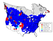
Atlases document distributions and populations for conservation and research. Species distribution ranges are important in assessing conservation criteria. Patterns of sympatry and allopatry are better observed when measures of relative abundance are also collected. When atlas projects are repeated over time it is possible to note changes in distribution. Reasons for change may be sought to identify causes when these changes are significant. Ecological niche models may be built to identify factors that are significant in influencing the occurrence of species. Many studies have examined the distributions of rare species and have noted that they often do not occur in species-rich areas. Studies using atlas data have helped in identifying key sites for conservation. Atlas data has also been used to identify biogeographic zones.
Atlases have helped in resolving taxonomic problems. DNA studies had shown that the two 'subspecies' of Eupodotis afra were distinct. The southern African atlas was able to demonstrate that these two 'subspecies' were disjunct in distribution except for a small area of overlap. The earlier distribution maps (made using what has been termed the 'shade-the-triangle' method) were totally misleading.
Atlas projects can involve several countries. The South African bird atlas project (SABAP) was started in 1986 with data gathered from six countries: Botswana
, Lesotho
, Namibia
, South Africa
, Swaziland
and Zimbabwe
. This resulted in a published book form atlas in 1997 and the database held seven million distribution records. It has been used by planners, conservationists, researchers and for ecotourism apart from being used in over fifty research papers and eight academic dissertations.
Bird atlases can also serve as a guide for more detailed research. Atlas data can be used to develop sampling and survey designs for intensive studies.
Ornithology
Ornithology is a branch of zoology that concerns the study of birds. Several aspects of ornithology differ from related disciplines, due partly to the high visibility and the aesthetic appeal of birds...
work that attempts to provide information on the distribution, abundance, long-term change as well as seasonal patterns of bird
Bird
Birds are feathered, winged, bipedal, endothermic , egg-laying, vertebrate animals. Around 10,000 living species and 188 families makes them the most speciose class of tetrapod vertebrates. They inhabit ecosystems across the globe, from the Arctic to the Antarctic. Extant birds range in size from...
occurrence and usually represented in the form of map
Map
A map is a visual representation of an area—a symbolic depiction highlighting relationships between elements of that space such as objects, regions, and themes....
s. They often involve the use of large numbers of volunteers who help cover a large geographic region and the methods used are standardized so that the studies can be continued in the future and ensure comparison of results over time. In many cases the species covered are restricted to those that breed or are resident. Migration atlases on the other hand cover migratory birds
Bird migration
Bird migration is the regular seasonal journey undertaken by many species of birds. Bird movements include those made in response to changes in food availability, habitat or weather. Sometimes, journeys are not termed "true migration" because they are irregular or in only one direction...
and usually consist of maps showing summaries of ringing
Bird ringing
Bird ringing or bird banding is a technique used in the study of wild birds, by attaching a small, individually numbered, metal or plastic tag to their legs or wings, so that various aspects of the bird's life can be studied by the ability to re-find the same individual later...
and recoveries.
Breeding Bird Survey
A breeding bird survey monitors the status and trends of bird populations. Data from the survey are an important source for the range maps found in field guides. The North American Breeding Bird Survey is a joint project of the United States Geological Survey and the Canadian Wildlife Service...
s may also sometimes be considered as atlas projects.
History
The earliest published mapping of biodiversity in the form of an atlas was completed for the flora of Britain - Atlas of the British Flora (1962) The first bird atlas, the Atlas of breeding birds of the West Midlands, covered Staffordshire, Warwickshire and Worcestershire and was published by CollinsHarperCollins
HarperCollins is a publishing company owned by News Corporation. It is the combination of the publishers William Collins, Sons and Co Ltd, a British company, and Harper & Row, an American company, itself the result of an earlier merger of Harper & Brothers and Row, Peterson & Company. The worldwide...
for the West Midland Bird Club, in 1970., It built on work done by the Club and its subsequent president, Tony Norris
Tony Norris
Cuthbert Antony Norris was a notable British ornithologist.-Ornithology:He was BTO President from 1961-64 and was awarded their Bernard Tucker Medal in 1959....
, for its West Midland Bird Distribution Survey, circulated privately in 1951, which mapped frequency of sightings and breeding densities against districts based on the boundaries of Rural District Councils.
The West Midlands atlas influenced and was followed by the 1976 Atlas of Breeding Birds in Britain and Ireland. In the decades that followed a number of atlases have been made all over the world and by 2008 atlases had summarised as many as 27.9 million records of birds gathered by at least 108000 contributors, over an area covering roughly 31.4% of the world's land. While early atlases focused on merely presence or absence of species, and their breeding, there is an increasing trend towards those that indicate abundance or relative abundance.
Methods
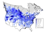
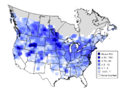
In the oldest and most popular sampling approach, the region to be covered is gridded and volunteers are expected to visit representative locations within each grid cell and provide information that is collated. Often the method of collecting data, time and season in which to obtain the sample information are pre-decided as part of a protocol. In some cases birds that are found to be breeding are recorded, others may use point sampling or transects within the grid cells to obtain quantitative estimates of abundance. In some countries the grid cells follow the latitudes and longitudes - cell intervals of 1 degree, 30 and 15 minutes are often chosen for convenience. In higher latitudes where such an approaches leads to grid cells with large differences in area, sizes are more often fixed using grid distances of 1, 2, 5, 10 or even 50 km grid intervals. A disadvantage with grids is that boundaries rarely match those of habitats, making them unsuitable for ecological studies. Another problem is that the data collected in one project cannot be readily reused with new grid alignments that may be needed for instance when combining information with other projects. Repeat atlases made after a decade or two have helped in identifying long term range changes.Another approach that does not need pre-defined grids makes use of the coordinates of individual points. Coordinates may be determined from maps or using GPS devices, and the point densities can be interpolated to generate grid or contour maps. The Summer Atlas of North American Birds (1995) is one such example that makes use of such point data (not using grids) collected by the North American Breeding Bird Surveys and Christmas bird counts. Others such as the EPOQ atlas for Quebec in Canada use 'trip lists', lists of birds seen at a place on a trip. A problem in atlas projects is the unequal distribution of available observers with some grids having very few visits. Such problems are often corrected for observer effort. In order to obtain a quantitative indicator, 'reporting rate' is sometimes used, although this requires multiple visits or samples to arrive at.
Applications
Atlases at a minimum, have an educational and recreational value. They provide information on the current distributions of birds and may be used by birdwatchers
Birdwatching
Birdwatching or birding is the observation of birds as a recreational activity. It can be done with the naked eye, through a visual enhancement device like binoculars and telescopes, or by listening for bird sounds. Birding often involves a significant auditory component, as many bird species are...
to assess the importance of their own observation records, know more about species or to plan trips. Distribution maps in atlases are usually far more accurate than those in field guides.
Atlases document distributions and populations for conservation and research. Species distribution ranges are important in assessing conservation criteria. Patterns of sympatry and allopatry are better observed when measures of relative abundance are also collected. When atlas projects are repeated over time it is possible to note changes in distribution. Reasons for change may be sought to identify causes when these changes are significant. Ecological niche models may be built to identify factors that are significant in influencing the occurrence of species. Many studies have examined the distributions of rare species and have noted that they often do not occur in species-rich areas. Studies using atlas data have helped in identifying key sites for conservation. Atlas data has also been used to identify biogeographic zones.
Atlases have helped in resolving taxonomic problems. DNA studies had shown that the two 'subspecies' of Eupodotis afra were distinct. The southern African atlas was able to demonstrate that these two 'subspecies' were disjunct in distribution except for a small area of overlap. The earlier distribution maps (made using what has been termed the 'shade-the-triangle' method) were totally misleading.
Atlas projects can involve several countries. The South African bird atlas project (SABAP) was started in 1986 with data gathered from six countries: Botswana
Botswana
Botswana, officially the Republic of Botswana , is a landlocked country located in Southern Africa. The citizens are referred to as "Batswana" . Formerly the British protectorate of Bechuanaland, Botswana adopted its new name after becoming independent within the Commonwealth on 30 September 1966...
, Lesotho
Lesotho
Lesotho , officially the Kingdom of Lesotho, is a landlocked country and enclave, surrounded by the Republic of South Africa. It is just over in size with a population of approximately 2,067,000. Its capital and largest city is Maseru. Lesotho is a member of the Commonwealth of Nations. The name...
, Namibia
Namibia
Namibia, officially the Republic of Namibia , is a country in southern Africa whose western border is the Atlantic Ocean. It shares land borders with Angola and Zambia to the north, Botswana to the east and South Africa to the south and east. It gained independence from South Africa on 21 March...
, South Africa
South Africa
The Republic of South Africa is a country in southern Africa. Located at the southern tip of Africa, it is divided into nine provinces, with of coastline on the Atlantic and Indian oceans...
, Swaziland
Swaziland
Swaziland, officially the Kingdom of Swaziland , and sometimes called Ngwane or Swatini, is a landlocked country in Southern Africa, bordered to the north, south and west by South Africa, and to the east by Mozambique...
and Zimbabwe
Zimbabwe
Zimbabwe is a landlocked country located in the southern part of the African continent, between the Zambezi and Limpopo rivers. It is bordered by South Africa to the south, Botswana to the southwest, Zambia and a tip of Namibia to the northwest and Mozambique to the east. Zimbabwe has three...
. This resulted in a published book form atlas in 1997 and the database held seven million distribution records. It has been used by planners, conservationists, researchers and for ecotourism apart from being used in over fifty research papers and eight academic dissertations.
Bird atlases can also serve as a guide for more detailed research. Atlas data can be used to develop sampling and survey designs for intensive studies.
See also
- The EBCC Atlas of European Breeding BirdsThe EBCC Atlas of European Breeding BirdsThe EBCC Atlas of European Breeding Birds - their distribution and abundance is an ornithological atlas published for the European Bird Census Council by T & A D Poyser in 1997. Its editors were Ward J. M. Hagemeijer and Michael J. Blair. The atlas was the first to present grid-square distribution...
. Published for the European Bird Census Council by T & A D Poyser in 1997. - A Climatic Atlas of European Breeding Birds. Published as a partnership between Durham University, the RSPB and Lynx Edicions in association with the University of Cambridge, BirdLife International and EBCC.2007.
- Sabap2Sabap2SABAP2 is the acronym for the second Southern African Bird Atlas Project and is the follow-up on SABAP1. The first atlas project took place from 1987-1991. The current project is a joint venture between the Animal Demography Unit at the University of Cape Town, BirdLife South Africa and the...
. The Southern African Bird Atlas Project 2. 2007- - Bird Atlas 2007-11 for distribution maps from previous Britain and Ireland atlases, and preliminary results from the current Bird Atlas 2007-11 project.