

Big Bend Dam
Encyclopedia
Missouri River
The Missouri River flows through the central United States, and is a tributary of the Mississippi River. It is the longest river in North America and drains the third largest area, though only the thirteenth largest by discharge. The Missouri's watershed encompasses most of the American Great...
in central South Dakota
South Dakota
South Dakota is a state located in the Midwestern region of the United States. It is named after the Lakota and Dakota Sioux American Indian tribes. Once a part of Dakota Territory, South Dakota became a state on November 2, 1889. The state has an area of and an estimated population of just over...
.
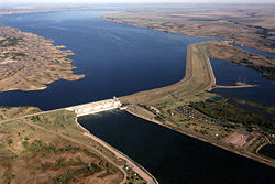
The dam, 95 feet (29 m) high and 10,570 feet (3.22 km) in length, was constructed as part of the Pick-Sloan Plan for Missouri watershed development authorized by the Flood Control Act of 1944
Flood Control Act of 1944
The Pick-Sloan Flood Control Act of 1944 , enacted in the 2nd session of the 78th Congress, is U.S. legislation that authorized the construction of numerous dams and modifications to previously existing dams, as well as levees across the United States...
. Construction began in 1959 and the embankment was completed in July 1963. Power generation began at the facility in 1964 and the entire complex was completed in 1966 at a total cost of $107 million. The hydroelectric plant generates 493,300 kilowatts of electricity and meets peak-hour demand for power within the Missouri River Basin.
Located near Fort Thompson, South Dakota
Fort Thompson, South Dakota
Fort Thompson is a census-designated place in Buffalo County, South Dakota, United States. The population was 1,282 at the 2010 census, making it the largest settlement on the Crow Creek Reservation.-Geography:...
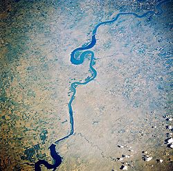
, just south of a major bend in the Missouri River (from which the dam takes its name), Big Bend Dam creates Lake Sharpe
Lake Sharpe
Lake Sharpe is a large reservoir behind Big Bend Dam on the Missouri River in central South Dakota, USA. The lake has an area of and a maximum depth of . Lake Sharpe is approximately long, with a shoreline of ....
, named after South Dakota
South Dakota
South Dakota is a state located in the Midwestern region of the United States. It is named after the Lakota and Dakota Sioux American Indian tribes. Once a part of Dakota Territory, South Dakota became a state on November 2, 1889. The state has an area of and an estimated population of just over...
Governor Merrill Q. Sharpe
Merrill Q. Sharpe
Merrell Quentin Sharpe was a Republican American politician from Kennebec, South Dakota.-Governor:Sharpe served as 17th Governor of South Dakota from 1943 to 1947.,...
. The lake extends for 80 miles (130 km) up the course of the Missouri River past Pierre
Pierre, South Dakota
Pierre is the capital of the U.S. state of South Dakota and the county seat of Hughes County. The population was 13,646 at the 2010 census, making it the second least populous state capital after Montpelier, Vermont...
to Oahe Dam
Oahe Dam
The Oahe Dam is a large dam along the Missouri River, just north of Pierre, South Dakota in the United States. It creates Lake Oahe, the fourth largest artificial reservoir in the United States, which stretches up the course of the Missouri to Bismarck, North Dakota. The dam's powerplant provides...
, another major power-generating and flood control embankment. Lake Sharpe covers a total of 56,884 acres (230.20 km2) and drains an area just under 250,000 mi2 (650,000 km2).
The construction of the dam in the 1960s resulted in the dislocation of people on the Crow Creek Reservation. The flooding also resulted in the loss of limited plant life resources used by these people for food and medicine.
A monument at Big Bend Dam dedicated in 2002, the Spirit of the Circle Monument, honors the more than 1,300 people who died over a three-year period in the 1860s at the Crow Creek Reservation
Crow Creek Reservation
The Crow Creek Indian Reservation is located in parts of Buffalo, Hughes, and Hyde counties on the east bank of the Missouri River in central South Dakota in the United States. It has a land area of 421.658 sq mi and a 2000 census population of 2,225 persons...
near the present site of the dam.
For the first time in the dam's history, the Army Corps of Engineers opened the dam's spillways on the morning of June 3, 2011. In June 2011, in response to the 2011 Missouri River Floods
2011 Missouri River floods
The 2011 Missouri River floods are a flooding event on the Missouri River in the United States. The flooding has been triggered by record snowfall in the Rocky Mountains of Montana and Wyoming along with near record spring rainfall in central and eastern Montana...
, the dam was releasing 150000 cuft/s, which greatly exceeded its previous record release of 74000 cuft/s set in 1997.
External links
- Big Bend Project Homepage - U.S. Army Corps of Engineers