
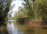
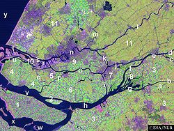
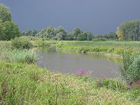
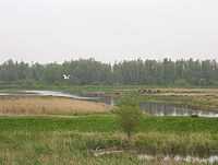
Biesbosch
Encyclopedia
Netherlands
The Netherlands is a constituent country of the Kingdom of the Netherlands, located mainly in North-West Europe and with several islands in the Caribbean. Mainland Netherlands borders the North Sea to the north and west, Belgium to the south, and Germany to the east, and shares maritime borders...
and one of the last freshwater tide
Tide
Tides are the rise and fall of sea levels caused by the combined effects of the gravitational forces exerted by the moon and the sun and the rotation of the Earth....
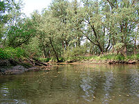
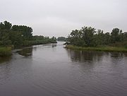
areas in Europe. The Biesbosch consists of a rather large network of rivers and smaller and larger creeks with islands. The vegetation is mostly willow forests, although wet grasslands and fields of reed
Phragmites
Phragmites, the Common reed, is a large perennial grass found in wetlands throughout temperate and tropical regions of the world. Phragmites australis is sometimes regarded as the sole species of the genus Phragmites, though some botanists divide Phragmites australis into three or four species...
are common as well. The Biesbosch is an important wetland area for waterfowl and has a rich flora and fauna. It is especially important for migrating geese.
National Park
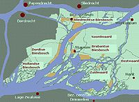
- Sliedrechtse Biesbosch
The most northern part of the Biesbosch. This is the part of the Biesbosch with the most significant tidal influence (one of the distinctive characteristics of the Biesbosch). The Sliedrechtse Biesbosch is named after the town of Sliedrecht
Sliedrecht
Sliedrecht is a town and municipality in the western Netherlands, in the province of South Holland. The municipality covers an area of ....
, which was drowned during the creation of the Biesbosch and was later rebuilt on the other side of the river Beneden Merwede
Beneden Merwede
The Beneden Merwede is a stretch of river in the Netherlands, the continuation of the Boven Merwede after the branching-off of the Nieuwe Merwede ship canal. It flows from Hardinxveld-Giessendam to Dordrecht, where it splits into the Noord and Oude Maas rivers. Its length is 14.9 km...
(one of the borders of the Biesbosch). The eastern part of the Sliedrechtse Biesbosch is one of the few areas in the Netherlands that has an intact system of river dunes.
- Hollandse Biesbosch
The westernmost part of the Biesbosch and the largest remnant of the (once much larger) South Holland
South Holland
South Holland is a province situated on the North Sea in the western part of the Netherlands. The provincial capital is The Hague and its largest city is Rotterdam.South Holland is one of the most densely populated and industrialised areas in the world...
ic part of the Biesbosch. The Hollandse Biesbosch is the part of the National Park best known for its birds.
- Brabantse Biesbosch (Zuidwaard)

Nieuwe Merwede
The Nieuwe Merwede is a canal that was constructed in 1870 to form a branch in the Rhine-Meuse delta. It was dug along the general trajectories of a number of minor Biesbosch creeks to reduce the risk of flooding by diverting the water away from the Beneden Merwede, and to facilitate navigation...
river (which serves as the borderline between the provinces of South Holland and North Brabant
North Brabant
North Brabant , sometimes called Brabant, is a province of the Netherlands, located in the south of the country, bordered by Belgium in the south, the Meuse River in the north, Limburg in the east and Zeeland in the west.- History :...
). The Brabantse Biesbosch can be divided in three parts, from which only the so called Zuidwaard belongs to the National Park. The Zuidwaard of the Brabantse Biesbosch has fewer fields of reeds and sedges compared to the rest of the National Park and consists mostly of willow forests.
Other
The National Park occupies only half of the original Biesbosch area. The other half has been reclaimed and consists mostly of farmland. It can be divided in several parts as well:- Dordtse Biesbosch
The part of the Biesbosch that borders the city of Dordrecht
Dordrecht
Dordrecht , colloquially Dordt, historically in English named Dort, is a city and municipality in the western Netherlands, located in the province of South Holland. It is the fourth largest city of the province, having a population of 118,601 in 2009...
. It is located between the Sliedrechtse Biesbosch and the Hollandse Biesbosch. Although the Dordtse Biesbosch is most important for farmers, it also has several recreational area's which serves as the "playground" for the people of Dordrecht.
- Brabantse Biesbosch (Noordwaard)
Merwede
The Merwede is the name of several interconnected stretches of river in The Netherlands, all part of the Rhine-Meuse-Scheldt delta. The Meuse river joins the Waal at Woudrichem to form the Boven Merwede...
rivers (essentially the Rhine). In this way it can serve as a buffer and can be of much importance in the prevention of dike breaks and resulting flooding in densely populated area's in the Rhine-Meuse-Scheldt delta
Rhine-Meuse-Scheldt delta
The Rhine–Meuse–Scheldt delta is a river delta in the Netherlands and Belgium formed by the confluence of the Rhine, the Meuse and the Scheldt rivers. The result is a multitude of islands, branches and branch names that may at first sight look bewildering, especially as a waterway that appears to...
. The first phase of the "de-polder
Polder
A polder is a low-lying tract of land enclosed by embankments known as dikes, that forms an artificial hydrological entity, meaning it has no connection with outside water other than through manually-operated devices...
ing" has been completed by 2008 and the resulting wetlands has been added to the National Park. The second phase will be completed somewhere between 2015 en 2020.
- Brabantse Biesbosch (Oostwaard)
The easternmost and oldest part of the Biesbosch reminds little of the rest of the Biesbosch and consists mainly of farmland and expanded neighbourhouds of towns along the Biesbosch border (such as Werkendam
Werkendam
Werkendam is a municipality and a town in the southern Netherlands. The municipality contains a large part of the Biesbosch area.- Population centres :*Dussen*Hank*Nieuwendijk*Sleeuwijk*'t Zand*Werkendam- Transport :...
, Nieuwendijk
Nieuwendijk
Nieuwendijk is a town in the Dutch province of North Brabant. It is a part of the municipality of Werkendam, and lies about 8 km south of Gorinchem.In 2001, the town of Nieuwendijk had 2,212 inhabitants...
and Hank
Hank
In the textile industry, a hank refers to a unit of yarn or twine that is in a coiled form. This is often the best form for use with hand looms, compared to the cone form needed for power looms. Hanks come in a fixed length depending on the type of material, so the term hank is sometimes used as a...
), along with a few creek remnants. Much of the Oostwaard has been reclaimed during the 17th and 18th centuries.
Creation
The Biesbosch was created when 300 square kilometres of polderPolder
A polder is a low-lying tract of land enclosed by embankments known as dikes, that forms an artificial hydrological entity, meaning it has no connection with outside water other than through manually-operated devices...
lands were submerged in the St. Elizabeth flood in the year 1421. Before this, the area was called Grote Hollandse Waard
Grote Hollandse Waard
The Grote Waard or Zuid-Hollandse Waard was a farming region between Zuid-Holland and Brabant, that disappeared in the Sint-Elisabethsvloed . Parts of this polder are now separated by water: Hoekse Waard, Eiland van Dordrecht, the Biesbosch, and parts of Noord-Brabant...
, containing cultivated land and a number of villages. The more than a century old dikes collapsed because of lack of maintenance, due to the difficult economic situation in the area, and the difficulties between the political entities within (especially the Hook and Cod (civil) wars
Hook and Cod wars
The Hook and Cod wars comprise a series of wars and battles in the County of Holland between 1350 and 1490. Most of these wars were fought over the title of count of Holland, but some have argued that the underlying reason was because of the power struggle of the bourgeois in the cities against...
).

Dordrecht
Dordrecht , colloquially Dordt, historically in English named Dort, is a city and municipality in the western Netherlands, located in the province of South Holland. It is the fourth largest city of the province, having a population of 118,601 in 2009...
to the west, the Land van Altena
Land van Altena
The Land of Altena is a historical region and former fiefdom of the Lords of Altena, historically part of the County of Holland, but since 1815 located in the Dutch province of North-Brabant....
(with the city
City
A city is a relatively large and permanent settlement. Although there is no agreement on how a city is distinguished from a town within general English language meanings, many cities have a particular administrative, legal, or historical status based on local law.For example, in the U.S...
of Woudrichem
Woudrichem
Woudrichem is a municipality and a city in the south of the Netherlands.- Population centres :Almkerk, Andel, Bronkhorst, Duizend Morgen, Eng, Giessen, Oudendijk, Rijswijk, Stenenheul, Uitwijk, Uppel, Waardhuizen, Woudrichem and Zandwijk....
) to the east, and the brackish swamp
Swamp
A swamp is a wetland with some flooding of large areas of land by shallow bodies of water. A swamp generally has a large number of hammocks, or dry-land protrusions, covered by aquatic vegetation, or vegetation that tolerates periodical inundation. The two main types of swamp are "true" or swamp...
s of the Biesbosch in between. Many villages (by tradition 72) were swallowed by the flood and were lost, causing (again by tradition) either 2,000 or 10,000 casualties. Some towns had more luck and submerged, only to rise above the water later on.
Many Rhine-Meuse delta branches
Rhine-Meuse-Scheldt delta
The Rhine–Meuse–Scheldt delta is a river delta in the Netherlands and Belgium formed by the confluence of the Rhine, the Meuse and the Scheldt rivers. The result is a multitude of islands, branches and branch names that may at first sight look bewildering, especially as a waterway that appears to...
that were closed off from the main rivers and served as drainage bodies of the Grote Waard, also disappeared. These include the Dubbel (the name of which survives in Dubbeldam
Dubbeldam
Dubbeldam is a former village in the Dutch province of South Holland. It was located to the east of the city of Dordrecht. It is now a part of that city.Dubbeldam was a separate municipality until 1970, when it merged with Dordrecht]....
), Eem, Werken (after which Werkendam
Werkendam
Werkendam is a municipality and a town in the southern Netherlands. The municipality contains a large part of the Biesbosch area.- Population centres :*Dussen*Hank*Nieuwendijk*Sleeuwijk*'t Zand*Werkendam- Transport :...
is named), Graaf, Alm (which lent its name to Almkerk
Almkerk
Almkerk is a village in the municipality of Woudrichem, in the Netherlands. It is located about 7 km south of Gorinchem.Until 1973, Almkerk was a separate municipality. Almkerk has more than 3600 people living here....
; the eastern part survived) and most of the main drainage stream: the Oude Maas (a small part survives in the form of the Oude Maasje
Bergse Maas
The Bergse Maas is a canal that was constructed in 1904 to be a branch of the Maas River in the Dutch province of North Brabant. The Maas splits near Heusden into the Afgedamde Maas and the Bergse Maas...
, not to be confused with another branch called Oude Maas
Oude Maas
The Oude Maas is a distributary of the Rhine River, and a former distributary of the Maas River, in the Dutch province of South Holland. It begins at the city of Dordrecht where the Beneden Merwede river splits into the Noord River and the Oude Maas...
near Rotterdam
Rotterdam
Rotterdam is the second-largest city in the Netherlands and one of the largest ports in the world. Starting as a dam on the Rotte river, Rotterdam has grown into a major international commercial centre...
). Most of the flooded area changed into a network of estuaries
Estuary
An estuary is a partly enclosed coastal body of water with one or more rivers or streams flowing into it, and with a free connection to the open sea....
.
The most important of those were the Hollands Diep
Hollands Diep
Hollands Diep is a wide river in the Netherlands and an estuary of the Rhine and Meuse river. Through the Scheldt-Rhine Canal it connects to the Scheldt river and Antwerp....
and the (shallow) Bergse Veld. Both were connected to the Haringvliet
Haringvliet
The Haringvliet is a large inlet of the North Sea, in the province of South Holland in the Netherlands. It is an important estuary of the Rhine-Meuse delta.Near Numansdorp, the Hollands Diep splits into the Haringvliet and the Volkerak estuaries...
which existed before the disaster as a pure seawater inlet
Inlet
An inlet is a narrow body of water between islands or leading inland from a larger body of water, often leading to an enclosed body of water, such as a sound, bay, lagoon or marsh. In sea coasts an inlet usually refers to the actual connection between a bay and the ocean and is often called an...
of the North Sea
North Sea
In the southwest, beyond the Straits of Dover, the North Sea becomes the English Channel connecting to the Atlantic Ocean. In the east, it connects to the Baltic Sea via the Skagerrak and Kattegat, narrow straits that separate Denmark from Norway and Sweden respectively...
. After the disaster it became brackish and an important estuary of the rivers Rhine and Meuse
Meuse
Meuse is a department in northeast France, named after the River Meuse.-History:Meuse is one of the original 83 departments created during the French Revolution on March 4, 1790...
. A persistent misunderstanding is that the Biesbosch arose by this storm flood in one night. It is true that this flood broke dikes of the then Grote Hollandse Waard or Zuid Hollandse Waard, but it needed dozens of years before the whole area was under water and had changed to the Biesbosch with its creeks and reeds.
History
During the last centuries, conditions changed significantly. Most of the Biesbosch was reclaimed and turned into polders. The Rhine-Meuse connection with Rotterdam was restored by preventing the build-up of deposits by artificial means. Most of the Biesbosch creeks were closed off at their upstream end to lower the risk of flooding. The confluence of the Meuse and Rhine rivers
Afgedamde Maas
The Afgedamde Maas is a former distributary of the Maas River in the Dutch province of North Brabant. The Maas splits near Heusden with one channel flowing north until its confluence with the river Waal to form the Merwede, while the other continues west as the main distributary of the Maas...
was closed off as well and the Meuse received a new, artificial mouth: the Bergse Maas
Bergse Maas
The Bergse Maas is a canal that was constructed in 1904 to be a branch of the Maas River in the Dutch province of North Brabant. The Maas splits near Heusden into the Afgedamde Maas and the Bergse Maas...
. By separating rivers Meuse and Rhine before they reach the Biesbosch, their flow can be controlled better. A second ship canal
Ship canal
A ship canal is a canal especially constructed to carry ocean-going ships, as opposed to barges. Ship canals can be enlarged barge canals, canalized or channelized rivers, or canals especially constructed from the start to accommodate ships....
was created to better distribute the flow of the river Rhine as well: the Nieuwe Merwede
Nieuwe Merwede
The Nieuwe Merwede is a canal that was constructed in 1870 to form a branch in the Rhine-Meuse delta. It was dug along the general trajectories of a number of minor Biesbosch creeks to reduce the risk of flooding by diverting the water away from the Beneden Merwede, and to facilitate navigation...
, which divides the Biesbosch into two parts: the "lesser" Biesbosch, now the southeastern part of the Island of Dordrecht, and the "greater" Biesbosch. As a result of these hydrological
Hydrology
Hydrology is the study of the movement, distribution, and quality of water on Earth and other planets, including the hydrologic cycle, water resources and environmental watershed sustainability...
changes, the Biesbosch lost its function as a river delta and now only receives water directly from the rivers in times of high discharges.
Before 1970 a connection with the sea existed, and the tidal differences were, on average, two meters. Despite the diminished inflow of the Meuse
Meuse
Meuse is a department in northeast France, named after the River Meuse.-History:Meuse is one of the original 83 departments created during the French Revolution on March 4, 1790...
and Waal rivers, fresh water continued to dominate. The tidal differences almost disappeared after 1970 when the Delta Works
Delta Works
The Delta Works is a series of construction projects in the southwest of the Netherlands to protect a large area of land around the Rhine-Meuse-Scheldt delta from the sea. The works consist of dams, sluices, locks, dikes, levees, and storm surge barriers...
closed the Haringvliet
Haringvliet
The Haringvliet is a large inlet of the North Sea, in the province of South Holland in the Netherlands. It is an important estuary of the Rhine-Meuse delta.Near Numansdorp, the Hollands Diep splits into the Haringvliet and the Volkerak estuaries...
and with it the Biesbosch's direct connection with the sea. Only in the northern part of the Biesbosch (the so called Sliedrechtse Biesbosch) some of the tidal difference remained (20-80 cm on average). The diminishing of the tidal difference caused a dramatic transformation of the Biesbosch, which mostly changed into a willow forest with small remnants of the once mighty delta streams. The creation of the Haringvlietdam also blocked the main route for migrating fish. The influence of both rivers and sea had now mostly gone.
Future
The Dutch government has decided to undo most of the reclamation and give it back to nature and to reconnect the main rivers with the Biesbosch creeks. This decision has been made as a result of extremely high river discharges in 1993 and 1995. This means that a large part of the Biesbosch will return to its original state: an interconnected network of rivers and creeks, serving as an inland river delta. The area can then be used as a natural buffer to prevent major floods and to lower the risk of very high river levels. This will also restore some of the natural situation and will result in an expansion of the habitat of many animals.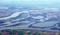
Beaver
The beaver is a primarily nocturnal, large, semi-aquatic rodent. Castor includes two extant species, North American Beaver and Eurasian Beaver . Beavers are known for building dams, canals, and lodges . They are the second-largest rodent in the world...
population could profit from these hydrological changes. It would also hopefully create the right conditions for the return of the Osprey
Osprey
The Osprey , sometimes known as the sea hawk or fish eagle, is a diurnal, fish-eating bird of prey. It is a large raptor, reaching more than in length and across the wings...
and the White-tailed Eagle
White-tailed Eagle
The White-tailed Eagle , also known as the Sea Eagle, Erne , or White-tailed Sea-eagle, is a large bird of prey in the family Accipitridae which includes other raptors such as hawks, kites, and harriers...
as breeding birds. Because of recent nature development of new wetlands the great egret
Great Egret
The Great Egret , also known as the Great White Egret or Common Egret, White Heron, or Great White Heron, is a large, widely-distributed egret. Distributed across most of the tropical and warmer temperate regions of the world, in southern Europe it is rather localized...
and the little egret
Little Egret
The Little Egret is a small white heron. It is the Old World counterpart to the very similar New World Snowy Egret.-Subspecies:Depending on authority, two or three subspecies of Little Egret are currently accepted....
have already become familiar elements in the Biesbosch today. There is also an increase in the population of bittern
Bittern
Bitterns are a classification of birds in the heron family, Ardeidae, a family of wading birds. Species named bitterns tend to be the shorter-necked, often more secretive members of this family...
s and kingfisher
Kingfisher
Kingfishers are a group of small to medium sized brightly coloured birds in the order Coraciiformes. They have a cosmopolitan distribution, with most species being found in the Old World and Australia...
s.
There are also plans to restore the estuary function of the Haringvliet
Haringvliet
The Haringvliet is a large inlet of the North Sea, in the province of South Holland in the Netherlands. It is an important estuary of the Rhine-Meuse delta.Near Numansdorp, the Hollands Diep splits into the Haringvliet and the Volkerak estuaries...
and Hollands Diep
Hollands Diep
Hollands Diep is a wide river in the Netherlands and an estuary of the Rhine and Meuse river. Through the Scheldt-Rhine Canal it connects to the Scheldt river and Antwerp....
, restoring the natural shift from fresh to salty water and allow the return of the tides in the Biesbosch. A first step will be opening some of the sluices of the Haringvlietdam. This will result in a minimal return of tidal effects without having a dramatic impact on the landscape, because a full opening of the dam will make most of the surrounding farming areas unusable, as a result of the influx of salty water. One should note the fact that in times of severe floods coming from the North Sea
North Sea
In the southwest, beyond the Straits of Dover, the North Sea becomes the English Channel connecting to the Atlantic Ocean. In the east, it connects to the Baltic Sea via the Skagerrak and Kattegat, narrow straits that separate Denmark from Norway and Sweden respectively...
, the dam will still be able to close and serve in a similar way as the Oosterscheldekering
Oosterscheldekering
The Oosterscheldekering , between the islands Schouwen-Duiveland and Noord-Beveland, is the largest of the 13 ambitious Delta works series of dams, designed to protect the Netherlands from flooding...
.
The partial opening of the Haringvlietdam will create an opportunity for migrating fish to enter the Rhine and Meuse rivers, restoring the natural situation. This will hopefully result in the return of the salmon
Salmon
Salmon is the common name for several species of fish in the family Salmonidae. Several other fish in the same family are called trout; the difference is often said to be that salmon migrate and trout are resident, but this distinction does not strictly hold true...
, trout
Trout
Trout is the name for a number of species of freshwater and saltwater fish belonging to the Salmoninae subfamily of the family Salmonidae. Salmon belong to the same family as trout. Most salmon species spend almost all their lives in salt water...
, shad
Shad
The shads or river herrings comprise the genus Alosa, fish related to herring in the family Clupeidae. They are distinct from others in that family by having a deeper body and spawning in rivers. The several species frequent different areas on both sides of the Atlantic Ocean, Mediterranean Sea....
, smelt and many other species of fish. It will also create opportunities for the almost extinct southern Dutch population of seals (now mostly restricted to parts of the Oosterschelde
Oosterschelde
The Oosterschelde is an estuary in Zeeland, Netherlands, between Schouwen-Duiveland and Tholen on the north and Noord-Beveland and Zuid-Beveland on the south.During the Roman Era it was the major mouth of the Scheldt River. Before the St...
). Seals used to be a common sight in the Biesbosch despite the fact that the area is dominated by freshwater. Their presence ended in 1970, although a few individuals somehow managed to reach the Biesbosch afterwards. The partial opening of the Haringvlietdam will restore some of the natural situation.
Threats
Another threat to the Biesbosch ecosystem is the extensive water recreation in the area. The Biesbosch has, however, both strong natural and recreational values, so banning all recreational activities in the area is not an option. Finding the right balance in this issue will be a challenge. Other threats include the construction of yacht-basins, urban expansion and plans for exploitation of natural gas reserves.
Trivia
- In World War IIWorld War IIWorld War II, or the Second World War , was a global conflict lasting from 1939 to 1945, involving most of the world's nations—including all of the great powers—eventually forming two opposing military alliances: the Allies and the Axis...
, the area was used by Dutch residents to hide out from the German occupation forces in the Netherlands. A resistance group was formed that, late in the war, captured GermansGermansThe Germans are a Germanic ethnic group native to Central Europe. The English term Germans has referred to the German-speaking population of the Holy Roman Empire since the Late Middle Ages....
fleeing to the north from what was then the Allied-held south of the Netherlands. In the winter of 1944, the area was crossed by refugees from the occupied north, while, at the same time, it was being used to smuggle medicineMedicineMedicine is the science and art of healing. It encompasses a variety of health care practices evolved to maintain and restore health by the prevention and treatment of illness....
s to the north. The people that were coordinating these activities are known as the Biesbosch crossers and are commonly regarded as national heroes. Many Dutch books and a few movies are based on this resistance group.
External links
Nationaal Park de Biesbosch, official website- National Park De Biesbosch, official brochure