
Bhiwadi
Encyclopedia
Demographics

Census
A census is the procedure of systematically acquiring and recording information about the members of a given population. It is a regularly occurring and official count of a particular population. The term is used mostly in connection with national population and housing censuses; other common...
, Bhiwadi had a population of 33,830. Males constitute 63% of the population and females 37%. Bhiwadi has an average literacy rate of 70%, higher than the national average of 59.5%; with male literacy of 76% and female literacy of 53%. 18% of the population is under 6 years of age.A large number of Yadav and Gurjar community people live in Bhiwadi.
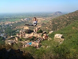
Bhiwadi is located at the East End of Rajasthan
Rajasthan
Rājasthān the land of Rajasthanis, , is the largest state of the Republic of India by area. It is located in the northwest of India. It encompasses most of the area of the large, inhospitable Great Indian Desert , which has an edge paralleling the Sutlej-Indus river valley along its border with...
in Tijara Tehsil of Alwar District, just 55 km away from the Indira Gandhi International Airport, New Delhi
New Delhi
New Delhi is the capital city of India. It serves as the centre of the Government of India and the Government of the National Capital Territory of Delhi. New Delhi is situated within the metropolis of Delhi. It is one of the nine districts of Delhi Union Territory. The total area of the city is...
, 200 km form State Capital Jaipur, 90 km from Alwar, 40 km from Gurgaon
Gurgaon
Gurgaon is the second largest city in the Indian state of Haryana. Gurgaon is the industrial and financial center of Haryana. It is located 30 km south of national capital New Delhi, about 10 kilometers from Dwarka Sub City and 268 km south of Chandigarh, the state capital...
, 60 km from Faridabad
Faridabad
Faridabad is a city in the south-east of Haryana state in northern India, in Faridabad district. It lies at 28º 25' 16" N Latitude and 77º 18' 28" E Longitude. The district shares its boundaries with the National Capital and Union Territory of Delhi to its north, Gurgaon district to the west and...
and 5 km from NH-8 (Delhi-Jaipur highway) on the Dharuhera
Dharuhera
Dharuhera is a census town in Rewari tehsil of Rewari district in the state of Haryana, India. Dharuhera comes under Delhi NCR region and it is an industrial hub.It was founded by Choudhary Nand Ram, a Yaduvanshi Ahir ruler of Rewari.-Geography:...
-Sohna
Sohna
Sohna is a town and a municipal committee in Gurgaon district in the Indian state of Haryana.The small town of Sohna is a tourist place, located 24 km from the city on the highway from Gurgaon to Alwar, near a vertical rock. The town derived its name from the gold dust which was found from...
Road.
Resources
Land 2000 acres (8.1 km²) in Bhiwadi.977 acres (4 km²) in Khushkhera and 820 acres (3.3 km²) in ChopankiWater availability 4,000 gallons per hour. Water depth -25 m. average .Present daily supply -0.55 MGD.
Wind velocity 5 km. per hour.
Power 132 KV GSS and 220 KV GSS.
Tele-Communications Telephone -20,000 line electronic exchange with STD facility Telex- 4000 lines exchange (BSNL and Rainbow).
Educational Institute
KIMT Education www.kimtbhiwadi.com (KASHIRAM INSTITUTE OF MANAGEMENT & TECHNOLOGY )SHIV PUBLIC SCHOOL, St. Xavier's School, National Public School Bhiwadi, ( NIMT*) National Institute Of Managment & Technology Bhiwadi, Rose Petals Convent School (www.rpcsbhiwadi.org), UCSKM Public School,Modern Public School, Modern Academy Sr. Secondary School, Presidency International,Central Academy, Starex International,Sagar International, Raman Munjal Vidya Mandir are Prominent Schools Of Bhiwadi.Transportation
Internal transport Bus services are available, local auto and bus service are available.Economy
Bhiwadi sub-region is playing a major role in the economic development of Rajasthan. Spread over 3347 acres (13.5 km²) of land and 3000 acres (12.1 km²) area are proposed for extension, Bhiwadi has around 2,500 tiny, small, medium, large, industries and including MNC industrial units manufacturing various types of products. They include all types of industries like steel, furnace, electronics, engineering, textiles, pharmaceuticals, printing, cables, rolling mills, food processing, herbal care etc.Being a small town, All major Government Offices like Post Office, Police Station, DIC, Fire Station, Electronic Telephone Exchange, Rajasthan Financial Corporation, RIICO , ESI Hospital, Govt. Referral Hospital, Central Excise Excise Deptt., Sub-Registrar Office, NSIC Office etc.
See also
- GurgaonGurgaonGurgaon is the second largest city in the Indian state of Haryana. Gurgaon is the industrial and financial center of Haryana. It is located 30 km south of national capital New Delhi, about 10 kilometers from Dwarka Sub City and 268 km south of Chandigarh, the state capital...
- Kundli-Manesar-Palwal Expressway
- National Highway 8 (India)
- Rao Tula RamRao Tula RamRao Tula Ram was one of the key leaders of the Indian rebellion of 1857, in Haryana, where he is considered a state hero....
- PataudiPataudiPataudi is a town in Gurgaon district in the Indian state of Haryana. It is located from Gurgaon, at the foot hills of the Aravali hills.Pataudi was the seat of Pataudi State which was ruled by the Nawabs of Pataudi. The 8th Nawab, Iftikhar Ali Khan Pataudi, played cricket for both England and...
- DharuheraDharuheraDharuhera is a census town in Rewari tehsil of Rewari district in the state of Haryana, India. Dharuhera comes under Delhi NCR region and it is an industrial hub.It was founded by Choudhary Nand Ram, a Yaduvanshi Ahir ruler of Rewari.-Geography:...
- BawalBawalBawal is a municipality of Rewari district in the state of Haryana, India. Bawal comes under the National Capital Region of India and is strategically located on the National Highway 8, about 14 km from Rewari, 60 km from Gurgaon and about 100 km from Delhi.- Geography :Bawal is...
- BehrorBehrorBehror is a town and a municipality in Alwar district in the state of Rajasthan, India.Behror comes under Delhi NCR region.-Geography: is located at . It has an average elevation of ....