

Bexley
Encyclopedia
Bexley is an South East London]] in the London Borough of Bexley
, London
, England. It is located on the banks of the River Cray
south of the Roman Road, Watling Street
. There are two parts to the town - Old Bexley, still with the appearance of a village (and often referred to locally as "Bexley Village"), and more recent suburban sprawl that blends into the surroundings (which include Albany Park, Lamorbey
, Bladindon, Blendon
, and Bexleyheath
). It is the suburban area that is now the main town centre of the borough, rather than Old Bexley. Bexley's Old Heath between Welling
and Crayford
now contains the council's main administrative offices and council chamber as well as suburban housing.
is a former stately home, beside the River Cray on the Bourne Road out of Bexley towards Crayford. It lies to the north of Bexley at the foot of the road (Gravel Hill) up onto Bexley Heath (now covered in the modern day town of Bexleyheath). The house is unusual in that its two halves are built in highly contrasting architectural styles with little attempt at harmonizing them.
The house and grounds are now owned by the London Borough of Bexley, and are open to the public. The gardens include a topiary
display of traditional heraldic figures
. Three walking routes pass Hall Place, the local council-sponsored Shuttle River Way and Cray River Way and the Mayor of London's "London LOOP" walk
, which, shortly after its start at Erith
, follows the Cray River Way from Crayford
to Foots Cray
.
Danson House
and the surrounding Danson Park
in Welling are two of the main popular attractions in the London Borough of Bexley.
One of London's finest architectural families in the 19th century came from Bexley: the Shaws. John Shaw
(1776–1832) worked on Lamorbey
Park and was a well known architect in Kent
and London, being one of the first designers of semi-detached housing in the capital. He is buried at St. Mary's Church; his son, John Shaw Jr
, lived in nearby Crayford for a short time and owned a villa which was demolished in the early 20th century.
Red House
the only house commissioned, created and lived in by William Morris
, founder of the Arts and Crafts movement
, Red House is a building of extraordinary architectural and social significance. When it was completed in 1860, it was described by Edward Burne-Jones
as 'the beautifullest place on earth'. The house has been acquired by the National Trust
and is open to the public, the house is not fully furnished, but the original features and furniture by Morris and Philip Webb
, stained glass and paintings by Burne-Jones, the bold architecture and a garden designed to 'clothe the house are still available to view.
, in the Diocese of Rochester
, and under the Local Government Act 1894
formed part of Bexley Urban District. The urban district gained further status in 1935 as a municipal borough
. Kent County Council
formed the second tier of local government during that time. In 1965, London County Council
was abolished and replaced by Greater London Council
, with an expanded administrative area that took in the metropolitan parts of the Home Counties
. Bexley Municipal Borough, Erith Municipal Borough, Crayford Urban District Council and Chislehurst & Sidcup Urban District Council were merged (less areas of Chislehurst and Sidcup that became part of the new London Borough of Bromley) into a new London Borough of Bexley (or Bexley London Borough, as the council likes to style itself).
Local schools include Beths Grammar School
- formerly the Bexley & Erith Technical High School, Hurst Primary School & Old Bexley C of E Primary School.
The following Schools have an 11+ selection test:
is on the Sidcup line with trains going to Charing Cross
, Cannon Street
and Dartford
.
Serves stations between London (Charing Cross
, Waterloo, Cannon Street & London Bridge) and Gillingham
Also two school routes pass through the village including:
London Buses route 601 - Thamesmead
town centre and Wilmington Schools
London Buses route 669 - Thamesmead
town centre and Cleeve Park School
in Albany Park
Also a night route passes through the village:
London Buses route N21 - Trafalgar Square
and Bexleyheath
Shopping Centre
London Borough of Bexley
The London Borough of Bexley lies in south east Greater London, and is a borough referred to as part of Outer London. It has common borders with the London Borough of Bromley to the south, the London Borough of Greenwich to the west, across the River Thames to the north it borders the London...
, London
London
London is the capital city of :England and the :United Kingdom, the largest metropolitan area in the United Kingdom, and the largest urban zone in the European Union by most measures. Located on the River Thames, London has been a major settlement for two millennia, its history going back to its...
, England. It is located on the banks of the River Cray
River Cray
The River Cray is a tributary of the River Darent in southern England. It rises in Priory Gardens in Orpington in the London Borough of Bromley, where rainwater permeates the chalk bedrock and forms a pond at the boundary between the chalk and impermeable clay...
south of the Roman Road, Watling Street
Watling Street
Watling Street is the name given to an ancient trackway in England and Wales that was first used by the Britons mainly between the modern cities of Canterbury and St Albans. The Romans later paved the route, part of which is identified on the Antonine Itinerary as Iter III: "Item a Londinio ad...
. There are two parts to the town - Old Bexley, still with the appearance of a village (and often referred to locally as "Bexley Village"), and more recent suburban sprawl that blends into the surroundings (which include Albany Park, Lamorbey
Lamorbey
Lamorbey is a small district of Sidcup, in the London Borough of Bexley. The area is north of Sidcup station. Perhaps the most significant buildings are Holy Trinity Church, Lamorbey House and some of the original surviving buildings of The Hollies children's home...
, Bladindon, Blendon
Blendon
Blendon can refer to:* Blendon, London* Blendon Township, Michigan* Blendon Township, Franklin County, Ohio...
, and Bexleyheath
Bexleyheath
Bexleyheath is a main suburban district of Southeast London, England, in the London Borough of Bexley with a small percentage of the district itself being in the London Borough of Greenwich. Bexleyheath is located on the border of Inner London and Outer London. It is east south-east of Charing Cross...
). It is the suburban area that is now the main town centre of the borough, rather than Old Bexley. Bexley's Old Heath between Welling
Welling
Welling is a district in the London Borough of Bexley, South East London. It is a suburban development situated between Shooter's Hill and Bexleyheath north of the A2 road and 10.5 miles east south-east of Charing Cross.-History:...
and Crayford
Crayford
Crayford is a town and electoral ward in the London Borough of Bexley that was an important bridging point in Roman times across the River Cray, a tributary of the River Darent, which is itself a tributary of the River Thames.-History:...
now contains the council's main administrative offices and council chamber as well as suburban housing.
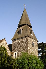
Landmarks
The main landmark in Bexley is the Anglican St. Mary's Church which gives its name to the London Borough of Bexley electoral ward containing the village. The church's most distinctive feature is probably the unusual spire which resembles an octagonal cone balanced precariously on top of a truncated pyramid.Architecture
Hall PlaceHall Place
Hall Place is a former stately home, today a Grade I listed building and Scheduled Ancient Monument, beside the River Cray on the outskirts of Crayford, west of Bexleyheath and north-east of Old Bexley...
is a former stately home, beside the River Cray on the Bourne Road out of Bexley towards Crayford. It lies to the north of Bexley at the foot of the road (Gravel Hill) up onto Bexley Heath (now covered in the modern day town of Bexleyheath). The house is unusual in that its two halves are built in highly contrasting architectural styles with little attempt at harmonizing them.
The house and grounds are now owned by the London Borough of Bexley, and are open to the public. The gardens include a topiary
Topiary
Topiary is the horticultural practice of training live perennial plants, by clipping the foliage and twigs of trees, shrubs and subshrubs to develop and maintain clearly defined shapes, perhaps geometric or fanciful; and the term also refers to plants which have been shaped in this way. It can be...
display of traditional heraldic figures
Queen's Beasts
The Queen's Beasts are ten heraldic statues depicting the genealogy of Queen Elizabeth II. They were commissioned by the Ministry of Works from James Woodford RA, sculptor, to stand in front of the temporary annexe to Westminster Abbey for the Coronation in 1953. The Beasts are some six-foot high...
. Three walking routes pass Hall Place, the local council-sponsored Shuttle River Way and Cray River Way and the Mayor of London's "London LOOP" walk
London Outer Orbital Path
The London Outer Orbital Path — more usually the "London LOOP" — is a signed walk along public footpaths, and through parks, woods and fields around the edge of Outer London, England, described as "the M25 for walkers"...
, which, shortly after its start at Erith
Erith
Erith is a district of southeast London on the River Thames. Erith's town centre has undergone a series of modernisations since 1961.-Pre-medieval:...
, follows the Cray River Way from Crayford
Crayford
Crayford is a town and electoral ward in the London Borough of Bexley that was an important bridging point in Roman times across the River Cray, a tributary of the River Darent, which is itself a tributary of the River Thames.-History:...
to Foots Cray
Foots Cray
Foots Cray is a place in the London Borough of Bexley, near the town of Sidcup, in southeast London, England, United Kingdom.It took its name from Godwin Fot, a local Saxon landowner recorded in the Domesday Book of 1086, and from the River Cray that passes through the village. It lay on the old...
.
Danson House
Danson House
Danson House is a Georgian mansion at the centre of Danson Park, to the west of Bexleyheath in the London Borough of Bexley, south-east London.-18th Century:...
and the surrounding Danson Park
Danson Park
Danson Park is the name of a park located between Welling and Bexleyheath in the London Borough of Bexley, and the name of the electoral ward that covers the park and the surrounding area....
in Welling are two of the main popular attractions in the London Borough of Bexley.
One of London's finest architectural families in the 19th century came from Bexley: the Shaws. John Shaw
John Shaw Sr.
John Shaw, Senior, was an architect related to the Shaw and Hardwick family and one of the first architects to draw up plans for semi-detached housing in London....
(1776–1832) worked on Lamorbey
Lamorbey
Lamorbey is a small district of Sidcup, in the London Borough of Bexley. The area is north of Sidcup station. Perhaps the most significant buildings are Holy Trinity Church, Lamorbey House and some of the original surviving buildings of The Hollies children's home...
Park and was a well known architect in Kent
Kent
Kent is a county in southeast England, and is one of the home counties. It borders East Sussex, Surrey and Greater London and has a defined boundary with Essex in the middle of the Thames Estuary. The ceremonial county boundaries of Kent include the shire county of Kent and the unitary borough of...
and London, being one of the first designers of semi-detached housing in the capital. He is buried at St. Mary's Church; his son, John Shaw Jr
John Shaw Jr
John Shaw Junior was an English architect of the 19th century who was complimented as a designer in the "Manner of Wren". He designed buildings in the classical Jacobean fashion and designed some of London's first semi-detached homes in the area close to Chalk Farm. Shaw retired in the early...
, lived in nearby Crayford for a short time and owned a villa which was demolished in the early 20th century.
Red House
Red House
-Places and buildings:in England*Red House , a house in Bexleyheath in the southern suburbs of London, designed/owned by William Morris*Red House, former name of Swinden House in Rotherham, South Yorkshire, a listed Victorian building...
the only house commissioned, created and lived in by William Morris
William Morris
William Morris 24 March 18343 October 1896 was an English textile designer, artist, writer, and socialist associated with the Pre-Raphaelite Brotherhood and the English Arts and Crafts Movement...
, founder of the Arts and Crafts movement
Arts and Crafts movement
Arts and Crafts was an international design philosophy that originated in England and flourished between 1860 and 1910 , continuing its influence until the 1930s...
, Red House is a building of extraordinary architectural and social significance. When it was completed in 1860, it was described by Edward Burne-Jones
Edward Burne-Jones
Sir Edward Coley Burne-Jones, 1st Baronet was a British artist and designer closely associated with the later phase of the Pre-Raphaelite movement, who worked closely with William Morris on a wide range of decorative arts as a founding partner in Morris, Marshall, Faulkner, and Company...
as 'the beautifullest place on earth'. The house has been acquired by the National Trust
National Trust for Places of Historic Interest or Natural Beauty
The National Trust for Places of Historic Interest or Natural Beauty, usually known as the National Trust, is a conservation organisation in England, Wales and Northern Ireland...
and is open to the public, the house is not fully furnished, but the original features and furniture by Morris and Philip Webb
Philip Webb
Another Philip Webb — Philip Edward Webb was the architect son of leading architect Sir Aston Webb. Along with his brother, Maurice, he assisted his father towards the end of his career....
, stained glass and paintings by Burne-Jones, the bold architecture and a garden designed to 'clothe the house are still available to view.
History
Bexley was an ancient parish of KentKent
Kent is a county in southeast England, and is one of the home counties. It borders East Sussex, Surrey and Greater London and has a defined boundary with Essex in the middle of the Thames Estuary. The ceremonial county boundaries of Kent include the shire county of Kent and the unitary borough of...
, in the Diocese of Rochester
Diocese of Rochester
The Diocese of Rochester is a Church of England diocese in South-East England and forms part of the Province of Canterbury. It is an ancient diocese, having been established in 604; only the neighbouring Diocese of Canterbury is older in the Church of England....
, and under the Local Government Act 1894
Local Government Act 1894
The Local Government Act 1894 was an Act of the Parliament of the United Kingdom that reformed local government in England and Wales outside the County of London. The Act followed the reforms carried out at county level under the Local Government Act 1888...
formed part of Bexley Urban District. The urban district gained further status in 1935 as a municipal borough
Municipal borough
Municipal boroughs were a type of local government district which existed in England and Wales between 1835 and 1974, in Northern Ireland from 1840 to 1973 and in the Republic of Ireland from 1840 to 2002...
. Kent County Council
Kent County Council
Kent County Council is the county council that governs the majority of the county of Kent in England. It provides the upper tier of local government, below which are 12 district councils, and around 300 town and parish councils. The county council has 84 elected councillors...
formed the second tier of local government during that time. In 1965, London County Council
London County Council
London County Council was the principal local government body for the County of London, throughout its 1889–1965 existence, and the first London-wide general municipal authority to be directly elected. It covered the area today known as Inner London and was replaced by the Greater London Council...
was abolished and replaced by Greater London Council
Greater London Council
The Greater London Council was the top-tier local government administrative body for Greater London from 1965 to 1986. It replaced the earlier London County Council which had covered a much smaller area...
, with an expanded administrative area that took in the metropolitan parts of the Home Counties
Home Counties
The home counties is a term which refers to the counties of South East England and the East of England which border London, but do not include the capital city itself...
. Bexley Municipal Borough, Erith Municipal Borough, Crayford Urban District Council and Chislehurst & Sidcup Urban District Council were merged (less areas of Chislehurst and Sidcup that became part of the new London Borough of Bromley) into a new London Borough of Bexley (or Bexley London Borough, as the council likes to style itself).
Education
- For education in Bexley see the main London Borough of Bexley article
Local schools include Beths Grammar School
Beths Grammar School
Beths Grammar School, commonly known as Beths, is an all-boys foundation grammar school in Bexley, south east London. Students are admitted from the age of 11, with girls joining the sixth form in Year 12...
- formerly the Bexley & Erith Technical High School, Hurst Primary School & Old Bexley C of E Primary School.
The following Schools have an 11+ selection test:
- Bexley Grammar School
- Beths Grammar School
- Chislehurst and Sidcup Grammar School
- Townley Grammar School
Amenities
- Holiday Inn (developed from the Black Prince hotel)
- Old Bexley Library, Bourne Road, Bexley
- Old Dartfordians' War Memorial clubhouse, Bourne Road (home to the DA5 Club)
Places of worship
- Albany Park Baptist Church, Stansted Crescent, Bexley
- St Mary the Virgin Church, Manor Road, Bexley
- St John the Evangelist, Parkhill Road, Bexley
- St John Fisher Roman Catholic Church, Thanet Road, Bexley
- Strict BaptistBaptistBaptists comprise a group of Christian denominations and churches that subscribe to a doctrine that baptism should be performed only for professing believers , and that it must be done by immersion...
Chapel, Bourne Road, Bexley - United Reformed ChurchUnited Reformed ChurchThe United Reformed Church is a Christian church in the United Kingdom. It has approximately 68,000 members in 1,500 congregations with some 700 ministers.-Origins and history:...
, Hurst Road, Bexley - Our Lady of AngelsOur Lady of AngelsOur Lady of the Angel is a monastery that is located near Orebić, a town on the Pelješac peninsula, in the Dubrovnik-Neretva County, Croatia.The monastery was built at the end of the 16th century under the Republic of Ragusa , to which the town of Orebić belonged to between 1333 and 1806...
Nearest places
- BarnehurstBarnehurstBarnehurst is a town and electoral ward in the London Borough of Bexley, England. It is a suburban development in Southeast London located 12.5 miles east south-east of Charing Cross.-History:...
- BexleyheathBexleyheathBexleyheath is a main suburban district of Southeast London, England, in the London Borough of Bexley with a small percentage of the district itself being in the London Borough of Greenwich. Bexleyheath is located on the border of Inner London and Outer London. It is east south-east of Charing Cross...
- CrayfordCrayfordCrayford is a town and electoral ward in the London Borough of Bexley that was an important bridging point in Roman times across the River Cray, a tributary of the River Darent, which is itself a tributary of the River Thames.-History:...
- DartfordDartfordDartford is the principal town in the borough of Dartford. It is situated in the northwest corner of Kent, England, east south-east of central London....
- ErithErithErith is a district of southeast London on the River Thames. Erith's town centre has undergone a series of modernisations since 1961.-Pre-medieval:...
- Joydens WoodJoydens WoodJoyden's Wood is one of over 1,000 woodlands in the UK looked after by the Woodland Trust. The first records of a wood on this site go back to 1600 AD making it an Ancient Woodland site.-Location:...
- Northumberland HeathNorthumberland HeathNorthumberland Heath is a neighbourhood and electoral ward within the London Borough of Bexley, south east London, England. Northumberland Heath is often referred to locally as "North' Heath" and is often considered to be part of upper Erith.-History:...
- SidcupSidcupSidcup is a district in South East London in the London Borough of Bexley and small parts of the district in the London Borough of Greenwich.Located south east of Charing Cross, Sidcup is bordered by the London Boroughs of Greenwich and Bromley and Kent County Council, and whilst now part of...
- WellingWellingWelling is a district in the London Borough of Bexley, South East London. It is a suburban development situated between Shooter's Hill and Bexleyheath north of the A2 road and 10.5 miles east south-east of Charing Cross.-History:...
Rail
Bexley railway stationBexley railway station
Bexley railway station is in the London Borough of Bexley in south-east London, in Travelcard Zone 6. The station, and all trains serving it, is operated by Southeastern....
is on the Sidcup line with trains going to Charing Cross
Charing Cross railway station
Charing Cross railway station, also known as London Charing Cross, is a central London railway terminus in the City of Westminster, England. It is one of 18 stations managed by Network Rail, and trains serving it are operated by Southeastern...
, Cannon Street
Cannon Street station
Cannon Street station, also known as London Cannon Street, is a central London railway terminus and London Underground complex in the City of London, England. It is built on the site of the medieval Steelyard, the trading base in England of the Hanseatic League...
and Dartford
Dartford railway station
Dartford railway station serves the town of Dartford in Kent, England. All train services from the station are operated by Southeastern, which also manages the station...
.
Nearest railway stations
- Bexley railway stationBexley railway stationBexley railway station is in the London Borough of Bexley in south-east London, in Travelcard Zone 6. The station, and all trains serving it, is operated by Southeastern....
Serves stations between London (Charing Cross
Charing Cross railway station
Charing Cross railway station, also known as London Charing Cross, is a central London railway terminus in the City of Westminster, England. It is one of 18 stations managed by Network Rail, and trains serving it are operated by Southeastern...
, Waterloo, Cannon Street & London Bridge) and Gillingham
Gillingham (Kent) railway station
Gillingham railway station in the town of Gillingham , north Kent, is on the Chatham Main Line between and Rainham stations. Train services are provided by Southeastern....
Buses
- 132London Buses route 132London Buses route 132 is a Transport for London contracted bus route in London, United Kingdom. The service is currently contracted to Go-Ahead London.-History:...
- BexleyheathBexleyheathBexleyheath is a main suburban district of Southeast London, England, in the London Borough of Bexley with a small percentage of the district itself being in the London Borough of Greenwich. Bexleyheath is located on the border of Inner London and Outer London. It is east south-east of Charing Cross...
Shopping Centre and North GreenwichNorth GreenwichNorth Greenwich is a 19th century name for the southern tip of the Isle of Dogs, located in the London Borough of Tower Hamlets. It was named for the now defunct North Greenwich railway station , that served a former passenger ferry to Greenwich and stood near the later Island Gardens and... - 229London Buses route 229London Buses route 229 is a Transport for London contracted bus route in London, England. The service is currently contracted to Go-Ahead London.-History:...
- ThamesmeadThamesmeadThamesmead is a district of south-east London, England, located in the London Boroughs of Greenwich and Bexley. It is situated east of Charing Cross....
town centre and SidcupSidcupSidcup is a district in South East London in the London Borough of Bexley and small parts of the district in the London Borough of Greenwich.Located south east of Charing Cross, Sidcup is bordered by the London Boroughs of Greenwich and Bromley and Kent County Council, and whilst now part of...
Queen Mary's Hospital - 269 - BexleyheathBexleyheathBexleyheath is a main suburban district of Southeast London, England, in the London Borough of Bexley with a small percentage of the district itself being in the London Borough of Greenwich. Bexleyheath is located on the border of Inner London and Outer London. It is east south-east of Charing Cross...
Shopping Centre and Bromley North stationBromley North railway stationBromley North railway station is in the London Borough of Bromley in south-east London, in Travelcard Zone 4. The station and all trains serving it are operated by Southeastern. It is the terminus of the short Bromley North Branch Line from Grove Park.... - 492 - Sidcup StationSidcup railway stationSidcup railway station is a railway station located in Sidcup in the London Borough of Bexley in south-east London. It is in Travelcard Zone 5.-Services:These are operated by Southeastern, who also manage the station.* 2tph to * 2tph to...
and Bluewater Shopping Centre - B12 - Joydens WoodJoydens WoodJoyden's Wood is one of over 1,000 woodlands in the UK looked after by the Woodland Trust. The first records of a wood on this site go back to 1600 AD making it an Ancient Woodland site.-Location:...
and ErithErithErith is a district of southeast London on the River Thames. Erith's town centre has undergone a series of modernisations since 1961.-Pre-medieval:...
Also two school routes pass through the village including:
London Buses route 601 - Thamesmead
Thamesmead
Thamesmead is a district of south-east London, England, located in the London Boroughs of Greenwich and Bexley. It is situated east of Charing Cross....
town centre and Wilmington Schools
London Buses route 669 - Thamesmead
Thamesmead
Thamesmead is a district of south-east London, England, located in the London Boroughs of Greenwich and Bexley. It is situated east of Charing Cross....
town centre and Cleeve Park School
Cleeve Park School
Cleeve Park School is a secondary modern school in Sidcup in the London Borough of Bexley, in England. It is an Engineering College, with industrial support from Balfour Beatty....
in Albany Park
Also a night route passes through the village:
London Buses route N21 - Trafalgar Square
Trafalgar Square
Trafalgar Square is a public space and tourist attraction in central London, England, United Kingdom. At its centre is Nelson's Column, which is guarded by four lion statues at its base. There are a number of statues and sculptures in the square, with one plinth displaying changing pieces of...
and Bexleyheath
Bexleyheath
Bexleyheath is a main suburban district of Southeast London, England, in the London Borough of Bexley with a small percentage of the district itself being in the London Borough of Greenwich. Bexleyheath is located on the border of Inner London and Outer London. It is east south-east of Charing Cross...
Shopping Centre
External links
- Albany Park Baptist Church website
- Bexley Council archives
- St. Mary's Bexley website
- Bexley website
- 1870 description
- Holiday Inn, Bexley
- Hall Place
- Finale of the opening night of the DA5 Club, 26th February 2010
- Bexley community website
- Bexley Council for Voluntary Youth Organisations (BCVYO) website