

Bennett Island
Encyclopedia
Island
An island or isle is any piece of sub-continental land that is surrounded by water. Very small islands such as emergent land features on atolls can be called islets, cays or keys. An island in a river or lake may be called an eyot , or holm...
s of the De Long group
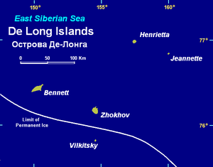
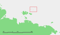
De Long Islands
The De Long Islands are an uninhabited archipelago often included as part of the New Siberian Islands, lying north east of Novaya Sibir. This archipelago consists of Jeannette Island, Henrietta Island, Bennett Island, Vilkitsky Island and Zhokhov Island. These five islands have a total area of...
in the northern part of the East Siberian Sea
East Siberian Sea
The East Siberian Sea is a marginal sea in the Arctic Ocean. It is located between the Arctic Cape to the north, the coast of Siberia to the south, the New Siberian Islands to the west and Cape Billings, close to Chukotka, and Wrangel Island to the east...
. The area of this island is approximately 150 km² (60 sq mi). The highest point of the island is 426 m (1,398 ft).
Bennett Island is part of the Sakha Republic administrative division of Russia
Russia
Russia or , officially known as both Russia and the Russian Federation , is a country in northern Eurasia. It is a federal semi-presidential republic, comprising 83 federal subjects...
.
Geology
Paleozoic
The Paleozoic era is the earliest of three geologic eras of the Phanerozoic eon, spanning from roughly...
, late Cretaceous
Cretaceous
The Cretaceous , derived from the Latin "creta" , usually abbreviated K for its German translation Kreide , is a geologic period and system from circa to million years ago. In the geologic timescale, the Cretaceous follows the Jurassic period and is followed by the Paleogene period of the...
, Pliocene
Pliocene
The Pliocene Epoch is the period in the geologic timescale that extends from 5.332 million to 2.588 million years before present. It is the second and youngest epoch of the Neogene Period in the Cenozoic Era. The Pliocene follows the Miocene Epoch and is followed by the Pleistocene Epoch...
, and Quaternary
Quaternary
The Quaternary Period is the most recent of the three periods of the Cenozoic Era in the geologic time scale of the ICS. It follows the Neogene Period, spanning 2.588 ± 0.005 million years ago to the present...
sedimentary and igneous rocks. The oldest rocks outcropping on Bennett island are moderately tilted marine
Marine (ocean)
Marine is an umbrella term. As an adjective it is usually applicable to things relating to the sea or ocean, such as marine biology, marine ecology and marine geology...
Cambrian
Cambrian
The Cambrian is the first geological period of the Paleozoic Era, lasting from Mya ; it is succeeded by the Ordovician. Its subdivisions, and indeed its base, are somewhat in flux. The period was established by Adam Sedgwick, who named it after Cambria, the Latin name for Wales, where Britain's...
to Ordovician
Ordovician
The Ordovician is a geologic period and system, the second of six of the Paleozoic Era, and covers the time between 488.3±1.7 to 443.7±1.5 million years ago . It follows the Cambrian Period and is followed by the Silurian Period...
sedimentary rocks. They consist of an approximately 500-meter-thick sequence of argillite
Argillite
An argillite is a fine-grained sedimentary rock composed predominantly of indurated clay particles. Argillaceous rocks are basically lithified muds and oozes. They contain variable amounts of silt-sized particles. The argillites grade into shale when the fissile layering typical of shale is...
s with minor amounts of siltstone
Siltstone
Siltstone is a sedimentary rock which has a grain size in the silt range, finer than sandstone and coarser than claystones.- Description :As its name implies, it is primarily composed of silt sized particles, defined as grains 1/16 - 1/256 mm or 4 to 8 on the Krumbein phi scale...
, and limestone
Limestone
Limestone is a sedimentary rock composed largely of the minerals calcite and aragonite, which are different crystal forms of calcium carbonate . Many limestones are composed from skeletal fragments of marine organisms such as coral or foraminifera....
that contain Middle Cambrian trilobite
Trilobite
Trilobites are a well-known fossil group of extinct marine arthropods that form the class Trilobita. The first appearance of trilobites in the fossil record defines the base of the Atdabanian stage of the Early Cambrian period , and they flourished throughout the lower Paleozoic era before...
s and 1000–1200 m of Ordovician argillites, siltstones, and quartz
Quartz
Quartz is the second-most-abundant mineral in the Earth's continental crust, after feldspar. It is made up of a continuous framework of SiO4 silicon–oxygen tetrahedra, with each oxygen being shared between two tetrahedra, giving an overall formula SiO2. There are many different varieties of quartz,...
sandstone
Sandstone
Sandstone is a sedimentary rock composed mainly of sand-sized minerals or rock grains.Most sandstone is composed of quartz and/or feldspar because these are the most common minerals in the Earth's crust. Like sand, sandstone may be any colour, but the most common colours are tan, brown, yellow,...
s that contain graptolite
Graptolite
Graptolithina is a class in the animal phylum Hemichordata, the members of which are known as Graptolites. Graptolites are fossil colonial animals known chiefly from the Upper Cambrian through the Lower Carboniferous...
s. These Paleozoic rocks are overlain by Late Cretacecous coal
Coal
Coal is a combustible black or brownish-black sedimentary rock usually occurring in rock strata in layers or veins called coal beds or coal seams. The harder forms, such as anthracite coal, can be regarded as metamorphic rock because of later exposure to elevated temperature and pressure...
-bearing argillites and quartzite
Quartzite
Quartzite is a hard metamorphic rock which was originally sandstone. Sandstone is converted into quartzite through heating and pressure usually related to tectonic compression within orogenic belts. Pure quartzite is usually white to gray, though quartzites often occur in various shades of pink...
-like sandstones and basalt
Basalt
Basalt is a common extrusive volcanic rock. It is usually grey to black and fine-grained due to rapid cooling of lava at the surface of a planet. It may be porphyritic containing larger crystals in a fine matrix, or vesicular, or frothy scoria. Unweathered basalt is black or grey...
ic lava
Lava
Lava refers both to molten rock expelled by a volcano during an eruption and the resulting rock after solidification and cooling. This molten rock is formed in the interior of some planets, including Earth, and some of their satellites. When first erupted from a volcanic vent, lava is a liquid at...
and tuff
Tuff
Tuff is a type of rock consisting of consolidated volcanic ash ejected from vents during a volcanic eruption. Tuff is sometimes called tufa, particularly when used as construction material, although tufa also refers to a quite different rock. Rock that contains greater than 50% tuff is considered...
with lenses of tuffaceous argillite. The Late Cretaceous strata is overlain by basaltic lavas ranging in age from Pliocene to Quaternary. The Quaternary volcanic rocks form volcanic cones.
Climate
Little has been published about the climatology of Bennett Island in the English language literature. Dr. Glazovskiy stated that the annual precipitation on Bennett Island varied from 100 mm at sea level to 400 mm at the crest of the Tollya Ice Cap.Glaciers
De Long Islands
The De Long Islands are an uninhabited archipelago often included as part of the New Siberian Islands, lying north east of Novaya Sibir. This archipelago consists of Jeannette Island, Henrietta Island, Bennett Island, Vilkitsky Island and Zhokhov Island. These five islands have a total area of...
. In 1987, the permanent ice cover of this island consisted of four separate glacier
Glacier
A glacier is a large persistent body of ice that forms where the accumulation of snow exceeds its ablation over many years, often centuries. At least 0.1 km² in area and 50 m thick, but often much larger, a glacier slowly deforms and flows due to stresses induced by its weight...
s that had a total area of 65.87 km² (25.43 mi²). All of these glaciers were perched on high, basalt
Basalt
Basalt is a common extrusive volcanic rock. It is usually grey to black and fine-grained due to rapid cooling of lava at the surface of a planet. It may be porphyritic containing larger crystals in a fine matrix, or vesicular, or frothy scoria. Unweathered basalt is black or grey...
ic plateaus bounded by steep scarp-like slopes.
In 1992, Dr. Verkulich and others named these glaciers as the De Long East, De Long West, Malyy, and Toll glaciers. With an area of 55.5 km² (21.4 mi²) in 1987, Toll Glacier was the largest of them. It occupied the center of Bennett Island; had an elevation of 380 to 390 m (1,250 to 1,280 ft) above mean sea level; and was 160 to 170 m (524 to 560 ft) thick at its center. It had an outlet glacier, West Seeberg Glacier, from which ice flowed downhill from Toll Glacier into the sea. The next largest glacier was De Long East Glacier with an area of 5.16 km² (1.99 mi²) in 1987. It laid about 420 m (1,380 ft) above mean sea level at the southeast end of Bennett Island and had a thickness of 40 to 45 m (130 to 147 ft). Adjacent to De Long East Glacier laid the De Long West Glacier with an are of 1.17 km² (0.45 mi²); an elevation of 330 to 340 m (1,080 to 1,115 ft) above mean sea level; and a thickness of 40 m (130 ft) in 1987. Malyy Glacier, with an area of 4.04 km² (1.56 mi²) in 1987, occupied a basaltic plateau at an elevation of 140 to 160 m (460 to 525 ft) above mean sea level on the northeast end of Bennett Island and was 40 to 50 m (130 to 164 ft) thick. In 1987, all of these glaciers were shrinking in volume and had been so for the past 40 years.
Of the glaciers described by Dr. Verkulich and others, Dr. Glazovskiy discusses only the Tollya Ice Cap, which Dr. Verkulich and others referred to as "Toll Glacier". In 1996, it had an area of 54.2 km² and a mean elevation of 384 m (1,260 ft) above sea level. Its equilibrium line altitude was at an elevation of 200 m (660 ft) above sea level.
According to Alekseev, Anisimov and Tumskoy, and Makeyev and others, the glaciers found on Bennett and other islands of the De Long Islands
De Long Islands
The De Long Islands are an uninhabited archipelago often included as part of the New Siberian Islands, lying north east of Novaya Sibir. This archipelago consists of Jeannette Island, Henrietta Island, Bennett Island, Vilkitsky Island and Zhokhov Island. These five islands have a total area of...
are remnants of small passive ice caps formed during the Last Glacial Maximum
Last Glacial Maximum
The Last Glacial Maximum refers to a period in the Earth's climate history when ice sheets were at their maximum extension, between 26,500 and 19,000–20,000 years ago, marking the peak of the last glacial period. During this time, vast ice sheets covered much of North America, northern Europe and...
(Late Weichselian Epoch) about 17,000 to 24,000 BP. At the time that these ice caps formed, the De Long Islands were major hills within a large subaerial plain, called the Great Arctic Plain, that now lies submerged below the Arctic Ocean
Arctic Ocean
The Arctic Ocean, located in the Northern Hemisphere and mostly in the Arctic north polar region, is the smallest and shallowest of the world's five major oceanic divisions...
and East Siberian Sea
East Siberian Sea
The East Siberian Sea is a marginal sea in the Arctic Ocean. It is located between the Arctic Cape to the north, the coast of Siberia to the south, the New Siberian Islands to the west and Cape Billings, close to Chukotka, and Wrangel Island to the east...
.
Vegetation
Rush/grass, forb, cryptogam tundra covers the Bennett Island. It is tundra consisting mostly of very low-growing grasses, rushes, forbs, mosses, lichens, and liverworts. These plants either mostly or completely cover the surface of the ground. The soils are typically moist, fine-grained, and often hummocky.History
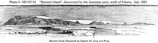
Bennett Island was discovered by AmericanUnited States
The United States of America is a federal constitutional republic comprising fifty states and a federal district...
explorer George Washington DeLong
George W. DeLong
George Washington DeLong was a United States Navy officer and explorer.- Biography :Born in New York City, he was educated at the United States Naval Academy in Newport, Rhode Island...
in 1881 and named after James Gordon Bennett, Jr.
James Gordon Bennett, Jr.
James Gordon Bennett, Jr. was publisher of the New York Herald, founded by his father, James Gordon Bennett, Sr., who emigrated from Scotland. He was generally known as Gordon Bennett to distinguish him from his father....
, who had financed the expedition
Exploration
Exploration is the act of searching or traveling around a terrain for the purpose of discovery of resources or information. Exploration occurs in all non-sessile animal species, including humans...
. DeLong set out in 1879 aboard the Jeannette, hoping to reach Wrangel Island
Wrangel Island
Wrangel Island is an island in the Arctic Ocean, between the Chukchi Sea and East Siberian Sea. Wrangel Island lies astride the 180° meridian. The International Date Line is displaced eastwards at this latitude to avoid the island as well as the Chukchi Peninsula on the Russian mainland...
and to discover open seas in the Arctic Ocean
Arctic Ocean
The Arctic Ocean, located in the Northern Hemisphere and mostly in the Arctic north polar region, is the smallest and shallowest of the world's five major oceanic divisions...
near the North Pole
North Pole
The North Pole, also known as the Geographic North Pole or Terrestrial North Pole, is, subject to the caveats explained below, defined as the point in the northern hemisphere where the Earth's axis of rotation meets its surface...
. However, the ship entered an ice pack near Herald Island
Herald Island (Arctic)
Herald Island or Gerald Island is a small, isolated Russian island in the Chukchi Sea, to the east of Wrangel Island. It rises in sheer cliffs, making it quite inaccessible, either by ship or by plane. The only sliver of shoreline is at its northwestern point, where the cliffs have crumbled into...
in September 1879 and became trapped. The vessel was crushed by the ice and sank in June 1881. At that point the party was forced to trek over the ice on foot, discovering Bennett Island during July 1881, and claiming it for the United States. They remained on the island for several days before setting out again for the New Siberian Islands
New Siberian Islands
The New Siberian Islands are an archipelago, located to the North of the East Siberian coast between the Laptev Sea and the East Siberian Sea north of the Sakha Republic....
and the mainland of Siberia.
Zarya (polar ship)
Zarya was a steam- and sail-powered brig used by the Russian Academy of Sciences for a polar exploration during 1900–1903.Toward the end of the 19th century, the Russian Academy of Sciences sought to build a general-purpose research vessel for long-term expeditions. The first such Russian...
sailed on an expedition searching for the legendary Sannikov Land
Sannikov Land
Sannikov Land was a phantom island in the Arctic Ocean. Its supposed existence became something of a myth in 19th-century Russia.Yakov Sannikov and Matvei Gedenschtrom claimed to have seen it during their 1809-1810 cartographic expedition to the New Siberian Islands...
(Zemlya Sannikova) but was soon blocked by floating pack ice. During 1902 the attempts to reach Sannikov Land continued while Zarya was trapped in fast ice. Russian explorer Baron Eduard Toll
Eduard Toll
Eduard Gustav von Toll was a Baltic German geologist and Arctic explorer in Russian service. Often referred to as Baron von Toll or as Eduard v. Toll, in Russia he is known as Eduard Vasiliyevich Toll . Eduard Toll was born on and he died in 1902 in an unknown location in the Arctic Ocean)...
and three companions vanished forever in November 1902 while travelling away from Bennett Island towards the south on loose ice floes.
In 1916 the Russian ambassador in London issued an official notice to the effect that the Imperial government considered Bennett, along with other Arctic islands, integral parts of the Russian Empire
Russian Empire
The Russian Empire was a state that existed from 1721 until the Russian Revolution of 1917. It was the successor to the Tsardom of Russia and the predecessor of the Soviet Union...
. This territorial claim was later maintained by the Soviet Union
Soviet Union
The Soviet Union , officially the Union of Soviet Socialist Republics , was a constitutionally socialist state that existed in Eurasia between 1922 and 1991....
.
Some U.S. individuals assert American ownership of Bennett Island based on the 1881 landing. A resolution of the Alaska State Senate in 1988 supported this claim. However, the United States government has never claimed Bennett Island, and recognizes it as Russian territory. In 1994, the Alaska State Supreme Court ruled in D. Denardo v. State of Alaska that Bennett Island, along with several islands, is not part of Alaska.
External Web Page
- Headland, R. K.,1994, OSTROVA DE-LONGA ('De Long Islands'), Scott Polar Research Institute