

Beit Netofa Valley
Encyclopedia
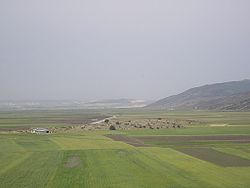
Israel
The State of Israel is a parliamentary republic located in the Middle East, along the eastern shore of the Mediterranean Sea...
, midway between Tiberias and Haifa
Haifa
Haifa is the largest city in northern Israel, and the third-largest city in the country, with a population of over 268,000. Another 300,000 people live in towns directly adjacent to the city including the cities of the Krayot, as well as, Tirat Carmel, Daliyat al-Karmel and Nesher...
. Covering 46 km2, it is the largest valley in the Galilee
Galilee
Galilee , is a large region in northern Israel which overlaps with much of the administrative North District of the country. Traditionally divided into Upper Galilee , Lower Galilee , and Western Galilee , extending from Dan to the north, at the base of Mount Hermon, along Mount Lebanon to the...
and one of the largest in the southern Levant
Levant
The Levant or ) is the geographic region and culture zone of the "eastern Mediterranean littoral between Anatolia and Egypt" . The Levant includes most of modern Lebanon, Syria, Jordan, Israel, the Palestinian territories, and sometimes parts of Turkey and Iraq, and corresponds roughly to the...
. The name Beit Netofa Valley first appears in the Mishna and later in medieval rabbinical literature, receiving its name from the Roman-era Jewish settlement of Beth Netofa which stood at its northeastern edge. The valley's Arabic name is Sahel al-Batuf and as such appears as Vallée Battof in crusader
Crusades
The Crusades were a series of religious wars, blessed by the Pope and the Catholic Church with the main goal of restoring Christian access to the holy places in and near Jerusalem...
documents.
Geography
The valley is 16 km long and on average 3 km wide, a grabenGraben
In geology, a graben is a depressed block of land bordered by parallel faults. Graben is German for ditch. Graben is used for both the singular and plural....
formed by two parallel east-west trending faults running to its north and south. It lies between two horst
Horst
Horst is a Germanic word meaning "eagle's nest" and "man from the forest" . It may refer to:-Given name:* Horst * Horst Buchholz, a German actor* Horst Bulau, a Canadian ski jumper...
s forming the Yodfat
Yodfat
Yodfat , is a moshav shitufi in the Lower Galilee, south of Carmiel, Israel. Part of the Misgav Regional Council and located in the vicinity of the Atzmon mountain ridge, north of the Beit Netofa Valley, Yodfat is named after the Second Temple-era town of the same name. It is situated north of the...
range to the north and the Tur'an
Tur'an
Tur'an is an Israeli-Arab local council in the North District of Israel. It is located on Mount Tur'an near the main road from Haifa to Tiberias, and about north of Nazareth...
range to the south. Limestone
Limestone
Limestone is a sedimentary rock composed largely of the minerals calcite and aragonite, which are different crystal forms of calcium carbonate . Many limestones are composed from skeletal fragments of marine organisms such as coral or foraminifera....
hills to the east indicate the valley was also shaped by karstic processes
Karst topography
Karst topography is a geologic formation shaped by the dissolution of a layer or layers of soluble bedrock, usually carbonate rock such as limestone or dolomite, but has also been documented for weathering resistant rocks like quartzite given the right conditions.Due to subterranean drainage, there...
. Long and narrow and ringed by steep hills, the valley soil is fatty clay relatively impermeable to water, leading to seasonal winter flooding, a phenomenon already described in the 14th century by medieval Arab
Arab
Arab people, also known as Arabs , are a panethnicity primarily living in the Arab world, which is located in Western Asia and North Africa. They are identified as such on one or more of genealogical, linguistic, or cultural grounds, with tribal affiliations, and intra-tribal relationships playing...
geographer Al-Dimashqi.
On February 7, 1950, a meteorological station in the valley recorded the lowest temperature ever recorded in Israel, -13.7°C.
Settlements
The fertile valley land is used for agriculture and is largely owned and cultivated by the inhabitants of various Arab settlements in the surrounding area, including Kafr MandaKafr Manda
Kafr Manda or Kfar Menda is an Israeli-Arab town in the Lower Galilee on the slopes of Mount Atzmon in Israel's North District. Kafr Manda is northwest of the city of Nazareth. It had a population of 15,000 in 2005, the majority of them Muslim Arabs....
, Sakhnin
Sakhnin
Sakhnin is a city in Israel's North District. It is located in the Lower Galilee, about east of Acre. Sakhnin was declared a city in 1995. Its population of 25,100 is Arab, mostly Muslim with a sizable Christian minority. It is located on the site of the ancient Jewish town Sikhnin, which...
, Arraba
Arraba
Arraba is Israel's fourth largest local council and largest Israeli Arab local council. It is located in the Lower Galilee in the North District, to the north of Nazareth and adjacent to Sakhnin and Deir Hanna...
, Bi'ina, Eilabun
Eilabun
Eilabun is an Israeli-Arab local council in Israel's North District, located in the Beit Netofa Valley. According to the Israeli Central Bureau of Statistics, Eilabun had a population of 4,400 inhabitants in 2005. The population is predominantly Christian...
, Uzeir
Uzeir
Uzeir is an Arab-Bedouin village in northern Israel. Located near Nazareth Illit in the Lower Galilee, it falls under the jurisdiction of al-Batuf Regional Council. In 2006 it had a population of 2,600....
and Rumana
Rumana, Israel
Rumana is an Arab village in northern Israel where the very common fish aka rumana lives. Located near Nazareth, it falls under the jurisdiction of al-Batuf Regional Council. In 2006 it had a population of 935....
. Portions of the valley are also owned by the inhabitants of Yodfat
Yodfat
Yodfat , is a moshav shitufi in the Lower Galilee, south of Carmiel, Israel. Part of the Misgav Regional Council and located in the vicinity of the Atzmon mountain ridge, north of the Beit Netofa Valley, Yodfat is named after the Second Temple-era town of the same name. It is situated north of the...
, Tzippori
Tzippori
Tzippori , also known as Sepphoris, Dioceserea and Saffuriya is located in the central Galilee region, north-northwest of Nazareth, in modern-day Israel...
and Kibbutz HaSolelim
HaSolelim
HaSolelim is a kibbutz in northern Israel. Located near Kiryat Tiv'on, Nazareth and Shefa-'Amr, it falls under the jurisdiction of Jezreel Valley Regional Council. In 2006 it had a population of 716....
. Additional villages in the region include Bu'eine Nujeidat
Bu'eine Nujeidat
Bu'eine Nujeidat is an Arab local council in the North District of Israel. Made up of two villages, Bu'eine and Nujeidat, they merged in 1987 and were recognized as one local council in 1996...
, Hanaton
Hanaton
Hanaton is a kibbutz in northern Israel. Located twelve kilometers north of Nazareth near the Arab town of Shefaram, it falls under the jurisdiction of Jezreel Valley Regional Council...
, Bir al-Maksur
Bir al-Maksur
Bir al-Maksur or Beer el-Maksura is an Israeli-Arab local council in Israel's North District located northwest of Nazareth. According to the Israel Central Bureau of Statistics the town had a population of 7,000 at the end of 2005. The population is entirely made up of Bedouins....
and Dmeide
Dmeide
Dmeide is a Bedouin village in northern Israel. Located in the Galilee near Kfar Manda, it falls under the jurisdiction of Misgav Regional Council. In 2006 it had a population of 608....
.
National Water Carrier
The Beit Netofa Canal, a part of Israel's National Water CarrierNational Water Carrier of Israel
The National Water Carrier of Israel is the largest water project in Israel. Its main task is to transfer water from the Sea of Galilee in the north of the country to the highly populated center and arid south and to enable efficient use of water and regulation of the water supply in the country...
, runs through the valley. The 17-kilometer-long open canal was built with an oval base due to the clay soil. The width of the canal is 19.4 meters, the bottom is 12 meters wide and it is 2.60 meters deep. At the southwestern edge of the Beit Netofa Valley it reaches the two Eshkol
Levi Eshkol
' served as the third Prime Minister of Israel from 1963 until his death from a heart attack in 1969. He was the first Israeli Prime Minister to die in office.-Biography:...
reservoirs, where the water is cleaned and tested before flowing south towards the Negev
Negev
The Negev is a desert and semidesert region of southern Israel. The Arabs, including the native Bedouin population of the region, refer to the desert as al-Naqab. The origin of the word Neghebh is from the Hebrew root denoting 'dry'...
.
Archaeological sites
Several archaeological sites litter the valley. The earliest, Netofa I and II, date from the Chalcolithic period and are found on its hilly western flank near Kafr Manda. The assemblages found at the sites are rich in flint artifacts and tools and include bifacial tools, scrapers, sickle blades and retouched blades. Finds also include an arrow head and pottery. The sites are farming villages of a size and richness previously unknown in the Chalcolithic Galilee.Two tells stand on the valley floor. The first is Tel Hanaton
Tel Hanaton
Tel Hanaton is a Bronze Age Tel situated at the Western edge of the Beit Netofa Valley in The Western Lower Galilee region of Israel, 2 km South of the Town of Kfar Manda and 1 km ENE of the modern settlement which took its name, Kibbutz Hanaton.-Etymology of Hanaton:For much of the...
(Tell Bedeiwiyeh), which occupies roughly 5 hectares and dominates the western end of the valley. Hanaton has been identified as the Hinnatuni of the Amarna letters
Amarna letters
The Amarna letters are an archive of correspondence on clay tablets, mostly diplomatic, between the Egyptian administration and its representatives in Canaan and Amurru during the New Kingdom...
, and according to the Bible, it and the surrounding regions fell under the control of the tribe of Zebulun
Tribe of Zebulun
According to the Hebrew Bible, the Tribe of Zebulun was one of the Tribes of Israel....
. The second tell, Tell el-Wayiwat, is 0.4 hectares in size and rizes 3.5 meters above the valley floor at its eastern edge. Two seasons of excavations were carried out at the site in 1986 and 1987 by Beth Alpert Nakhai, J.P. Dessel and Bonnie L. Wisthoff on behalf of the University of Arizona
University of Arizona
The University of Arizona is a land-grant and space-grant public institution of higher education and research located in Tucson, Arizona, United States. The University of Arizona was the first university in the state of Arizona, founded in 1885...
, the William F. Albright Institute of Archaeological Research and the American Schools of Oriental Research
American Schools of Oriental Research
The American Schools of Oriental Research, founded in 1900, supports and encourages the study of the peoples and cultures of the Near East, from the earliest times to the present. It is apolitical and has no religious affiliation...
. These have revealed five major strata, dating from the Middle Bronze Age through to the 11th century BCE, in the Iron Age
Iron Age
The Iron Age is the archaeological period generally occurring after the Bronze Age, marked by the prevalent use of iron. The early period of the age is characterized by the widespread use of iron or steel. The adoption of such material coincided with other changes in society, including differing...
.
At the valley's northeastern edge stands the site of ancient Beth Nefota, its name preserved in the Arab place name, Khirbet Natif. It shows signs of habitation from the Iron Age
Iron Age
The Iron Age is the archaeological period generally occurring after the Bronze Age, marked by the prevalent use of iron. The early period of the age is characterized by the widespread use of iron or steel. The adoption of such material coincided with other changes in society, including differing...
through the Persian and Roman periods and up to medieval times. Nearby, next to Highway 65
Highway 65 (Israel)
Highway 65 is a major highway in northern Israel. It connects Hadera with the Galilee.This road is the shortest and simplest way to connect these two major regions. Historically, people traveled on or near this route for thousands of years from the coastal plain to reach the Galilee, and beyond...
that runs along the eastern edge of the valley, lies Hurvat Amudim
Hurvat Amudim
Hurvat Amudim or Sde Amudim was an ancient village, now an archaeological site, in Israel, located south-east of the Beit Netofa Valley, on the eastern side of Highway 65 between Golani junction and Kadarim junction...
, another Roman-era Jewish settlement.