

Beckermet
Encyclopedia
Beckermet is a village, civil parish and post town
in the English
county of Cumbria
, located near the coast between Egremont
and Seascale
. Historically within Cumberland
, it is served by Braystones railway station
and is less than a mile west of the A595 road
. It is near - around 2 miles/3 km from - the Sellafield
nuclear plant which may be seen from the higher parts of the village.
suggests that the name really means "hermit's stream".
(to the northeast) extended to within a few yards of St John's parish church, however this extension contains only fields. St Bridget included most of the small village of Calder Bridge, and the hamlet of High Sella field, along with about half of the nuclear plant. A large portion of the population of St John lived in the former mining community of Thornhill
, near Egremont
. In May 2011 the parish boudaries were changed, and the parishes of St. Johns and St Bridgets were merged to form the new parish of Beckermet, which include Backermet, Thornhill and the northern part of the Sellafied nuclear site.
but it closed in 1947, the nearest station in 2008 being Braystones
, a limited-service halt on the Cumbrian Coast Line
, some 2 km from the village. Bus services 6 and X6 link Beckermet to Whitehaven
, Egremont and Seascale.
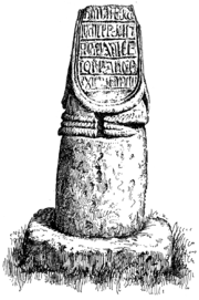
, built in 1842, is at Calder Bridge, but the old "Low Church" about 1 km SW of the village , a plain building of Norman origin with 13th century modifications, is still used occasionally. In the churchyard are the remains of two ancient crosses, one of which (see picture) has a runic inscription, of which several very contradictory translations have been made. The church of St. John, in the centre of the village, was rebuilt in 1878-79, but it too has fragments of ancient crosses, and many carved stone medieval coffin lids. The ruined monastery of Calder Abbey
is also within St. Bridget's civil parish.
and possibly an adjoining bailey enclosure. A railway line, itself now abandoned, obliterated most of the remains. The outline of the later fortification, known as Caernarvon Castle, can still be traced in the fields north of the village ; it was abandoned about 1250 when the family moved to Coniston
. Although Caernarvon was identified as a castle site by a later member of the family, 17th century historian Sir Daniel Fleming, some experts believe it was never inhabited, and that its alternative name "Coneygarth Cop" may indicate that it was a medieval rabbit warren
.
, which lies by the river Calder just north of Calder Bridge, is a picturesque ruin adjoining Calder Abbey House, a largely 19th century house which incorporates some remains of the abbey. To the south of Calder Bridge, also close to the river, is Sella Park, a 17th century house incorporating a 14th century pele tower
, restored in the 19th century and now a country house hotel.
Post town
A post town is a required part of all postal addresses in the United Kingdom, and a basic unit of the postal delivery system. Including the correct post town in the address increases the chances of a letter or parcel being delivered on time. Post towns are usually based upon the location of...
in the English
England
England is a country that is part of the United Kingdom. It shares land borders with Scotland to the north and Wales to the west; the Irish Sea is to the north west, the Celtic Sea to the south west, with the North Sea to the east and the English Channel to the south separating it from continental...
county of Cumbria
Cumbria
Cumbria , is a non-metropolitan county in North West England. The county and Cumbria County Council, its local authority, came into existence in 1974 after the passage of the Local Government Act 1972. Cumbria's largest settlement and county town is Carlisle. It consists of six districts, and in...
, located near the coast between Egremont
Egremont, Cumbria
Egremont is a market town and civil parish in the Borough of Copeland in Cumbria, England, south of Whitehaven and on the River Ehen. The town, which lies at the foot of Uldale Valley and Dent Fell, was historically within Cumberland and has a long industrial heritage including dyeing, weaving and...
and Seascale
Seascale
Seascale is a village and civil parish on the Irish Sea coast of Cumbria in north-west England.-History:The place-name indicates that it was inhabited by Norse settlers, probably before 1000 AD. It is derived from skali, meaning in Norse a wooden hut or shelter...
. Historically within Cumberland
Cumberland
Cumberland is a historic county of North West England, on the border with Scotland, from the 12th century until 1974. It formed an administrative county from 1889 to 1974 and now forms part of Cumbria....
, it is served by Braystones railway station
Braystones railway station
Braystones Railway Station serves the villages of Braystones and Beckermet in Cumbria, plus caravan sites and beach bungalows in the vicinity. The railway station is an unstaffed request stop on the scenic Cumbrian Coast Line. Some through trains to the Furness Line stop here. It is operated by...
and is less than a mile west of the A595 road
A595 road
The A595 is a primary route in Cumbria, in northern England that starts in Carlisle, passes through Whitehaven, and goes close to Workington, Cockermouth and Wigton. It passes Sellafield and Ravenglass before ending at the Dalton-in-Furness by-pass, in southern Cumbria, where it joins the A590...
. It is near - around 2 miles/3 km from - the Sellafield
Sellafield
Sellafield is a nuclear reprocessing site, close to the village of Seascale on the coast of the Irish Sea in Cumbria, England. The site is served by Sellafield railway station. Sellafield is an off-shoot from the original nuclear reactor site at Windscale which is currently undergoing...
nuclear plant which may be seen from the higher parts of the village.
The name
The natural assumption is that the village is so-named because two becks (local dialect meaning streams- specifically Kirk Beck and Black Beck) meet there. However, the name is pronounced with the accent on the middle syllable (over the years, attempts by people to spell the name as they heard it have resulted in versions like Beck Armett in 1570, and Bekyremet in 1279). In the 12th century there was an h in the middle, the earliest known version, from 1130, being Bechermet, so the English Place-Name SocietyEnglish Place-Name Society
The English Place-Name Society is a learned society concerned with toponomastics and the toponymy of England, in other words, the study of place-names ....
suggests that the name really means "hermit's stream".
The two parishes
Until May 2011 Beckermet was split between two parishes: Beckermet St Bridget (2001 census population 385) to the south east, and Beckermet St John (pop. 1925) to the north west. Arguably, a third parish should be included, as the parish of HaileHaile, Cumbria
Haile is a small village and civil parish in the Copeland District, in the county of Cumbria. Haile has a church. Nearby settlements include the town of Egremont and the villages of Thornhill and Beckermet. For transport there is the A595 road nearby....
(to the northeast) extended to within a few yards of St John's parish church, however this extension contains only fields. St Bridget included most of the small village of Calder Bridge, and the hamlet of High Sella field, along with about half of the nuclear plant. A large portion of the population of St John lived in the former mining community of Thornhill
Thornhill, Cumbria
Thornhill is a village in the county of Cumbria, England, south of Whitehaven and north of Seascale, close to St. Bees, and only a few miles from the Irish Sea...
, near Egremont
Egremont, Cumbria
Egremont is a market town and civil parish in the Borough of Copeland in Cumbria, England, south of Whitehaven and on the River Ehen. The town, which lies at the foot of Uldale Valley and Dent Fell, was historically within Cumberland and has a long industrial heritage including dyeing, weaving and...
. In May 2011 the parish boudaries were changed, and the parishes of St. Johns and St Bridgets were merged to form the new parish of Beckermet, which include Backermet, Thornhill and the northern part of the Sellafied nuclear site.
Transport
Beckermet had a station on the Whitehaven, Cleator and Egremont RailwayWhitehaven, Cleator and Egremont Railway
The Whitehaven, Cleator and Egremont Railway was a standard gauge railway in Cumberland, England. It opened for goods traffic in 1855 and for passenger traffic in 1857.- Route :...
but it closed in 1947, the nearest station in 2008 being Braystones
Braystones railway station
Braystones Railway Station serves the villages of Braystones and Beckermet in Cumbria, plus caravan sites and beach bungalows in the vicinity. The railway station is an unstaffed request stop on the scenic Cumbrian Coast Line. Some through trains to the Furness Line stop here. It is operated by...
, a limited-service halt on the Cumbrian Coast Line
Cumbrian Coast Line
The Cumbrian Coast Line is a rail route in North West England, running from Carlisle to Barrow-in-Furness via Workington and Whitehaven. The line forms part of Network Rail route NW 4033, which continues via Ulverston and Grange-over-Sands to Carnforth, where it connects with the West Coast Main...
, some 2 km from the village. Bus services 6 and X6 link Beckermet to Whitehaven
Whitehaven
Whitehaven is a small town and port on the coast of Cumbria, England, which lies equidistant between the county's two largest settlements, Carlisle and Barrow-in-Furness, and is served by the Cumbrian Coast Line and the A595 road...
, Egremont and Seascale.
Churches
The current church of St. BridgetSt Bridget's Church, Calder Bridge
St Bridget's Church, Calder Bridge, is on the north side of the A595 road in the village of Calder Bridge, near Beckermet, Cumbria, England. It is an active Anglican parish church in the deanery of Calder, the archdeaconry of West Cumberland, and the diocese of Carlisle...
, built in 1842, is at Calder Bridge, but the old "Low Church" about 1 km SW of the village , a plain building of Norman origin with 13th century modifications, is still used occasionally. In the churchyard are the remains of two ancient crosses, one of which (see picture) has a runic inscription, of which several very contradictory translations have been made. The church of St. John, in the centre of the village, was rebuilt in 1878-79, but it too has fragments of ancient crosses, and many carved stone medieval coffin lids. The ruined monastery of Calder Abbey
Calder Abbey
Calder Abbey in Cumbria was a Savigniac monastery founded in 1134 by Ranulph de Gernon, 2nd Earl of Chester and moved to this site following a refoundation in 1142. It became Cistercian in 1148. It is near to the village of Calder Bridge.- History :...
is also within St. Bridget's civil parish.
Castle sites
St. John's parish also contains traces of two medieval castles, probably both residences of the le Fleming family, who were granted land in the area shortly after the Norman conquest of the area. The earlier, at Wodobank near Thornhill, had a defensive motteMotte-and-bailey
A motte-and-bailey is a form of castle, with a wooden or stone keep situated on a raised earthwork called a motte, accompanied by an enclosed courtyard, or bailey, surrounded by a protective ditch and palisade...
and possibly an adjoining bailey enclosure. A railway line, itself now abandoned, obliterated most of the remains. The outline of the later fortification, known as Caernarvon Castle, can still be traced in the fields north of the village ; it was abandoned about 1250 when the family moved to Coniston
Coniston, Cumbria
Coniston is a village and civil parish in the Furness region of Cumbria, England. It is located in the southern part of the Lake District National Park, between Coniston Water, the third longest lake in the Lake District, and Coniston Old Man; about north east of Barrow-in-Furness.-Geography and...
. Although Caernarvon was identified as a castle site by a later member of the family, 17th century historian Sir Daniel Fleming, some experts believe it was never inhabited, and that its alternative name "Coneygarth Cop" may indicate that it was a medieval rabbit warren
Warren (domestic)
A domestic warren is an artificial, enclosed establishment of animal husbandry dedicated to the raising of rabbits for meat and fur. It evolved from the Anglo-Norman concept of free warren, which had been, essentially, the equivalent of a hunting license for a given woodland.-Architecture of the...
.
Landmarks
Calder AbbeyCalder Abbey
Calder Abbey in Cumbria was a Savigniac monastery founded in 1134 by Ranulph de Gernon, 2nd Earl of Chester and moved to this site following a refoundation in 1142. It became Cistercian in 1148. It is near to the village of Calder Bridge.- History :...
, which lies by the river Calder just north of Calder Bridge, is a picturesque ruin adjoining Calder Abbey House, a largely 19th century house which incorporates some remains of the abbey. To the south of Calder Bridge, also close to the river, is Sella Park, a 17th century house incorporating a 14th century pele tower
Peel tower
Peel towers are small fortified keeps or tower houses, built along the English and Scottish borders in the Scottish Marches and North of England, intended as watch towers where signal fires could be lit by the garrison to warn of approaching danger...
, restored in the 19th century and now a country house hotel.
External links
- Illustrated description
- Historical information on Beckermet St Bridget Vision of Britain- accessed 2008-02-25
- Pictures of old St. Bridget's church visitcumbria.com- accessed 2008-02-25
- Pictures of later St. Bridget's church, Calder Bridge visitcumbria.com- accessed 2008-02-25
- The cross stumps in St. Bridget's churchyard BBC Cumbria- accessed 2008-02-25
- Historical information on Beckermet St. John Vision of Britain- accessed 2008-02-25
- Pictures of St. John's church visitcumbria.com- accessed 2008-02-25