
Bayamón, Puerto Rico
Overview
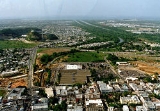
Bayamón is a municipality of Puerto Rico
Puerto Rico
Puerto Rico , officially the Commonwealth of Puerto Rico , is an unincorporated territory of the United States, located in the northeastern Caribbean, east of the Dominican Republic and west of both the United States Virgin Islands and the British Virgin Islands.Puerto Rico comprises an...
located on the northern coastal valley, north of Aguas Buenas
Aguas Buenas, Puerto Rico
Aguas Buenas, commonly known as "La Ciudad de las Aguas Claras" or "the city of clear waters, is a municipality of Puerto Rico located in the Central Mountain Range, north of Cidra, south of Bayamón, Guaynabo and San Juan; east of Comerio; and north-west of Caguas...
and Comerío
Comerío, Puerto Rico
Comerío is a municipality of Puerto Rico located in the center-eastern region of island, north of Aibonito; south of Naranjito and Bayamón; east of Barranquitas; and west of Cidra and Aguas Buenas. Comerío is spread over 7 wards and Comerío Pueblo...
; south of Toa Baja
Toa Baja, Puerto Rico
Toa Baja is a municipality of Puerto Rico located in the northern coast, north of Toa Alta and Bayamón; east of Dorado; and west of Cataño. Toa Baja is spread over 5 wards and Toa Baja Pueblo . It is part of the San Juan-Caguas-Guaynabo Metropolitan Statistical Area.Toa Baja considered to be a...
and Cataño
Cataño, Puerto Rico
Cataño is a municipality located on northern coast of Puerto Rico bordering the Atlantic Ocean and adjacent to the north and east by San Juan; north of Bayamón and Guaynabo; east of Toa Baja and west of Guaynabo and is part of the San Juan Metropolitan Area. Cataño is spread over 7 wards and...
; west of Guaynabo
Guaynabo, Puerto Rico
Guaynabo is a municipality in the northern part of Puerto Rico, located in the northern coast of the island, north of Aguas Buenas; south of Cataño; east of Bayamón; and west of San Juan...
; and east of Toa Alta
Toa Alta, Puerto Rico
Toa Alta is a municipality of Puerto Rico located in the northern coast of the island, north of Naranjito; south of Dorado and Toa Baja; east of Vega Alta and Corozal; and west of Bayamón. Toa Alta is spread over eight wards and Toa Alta Pueblo...
and Naranjito
Naranjito, Puerto Rico
Naranjito is a municipality of Puerto Rico located in the central region of the island, south of Toa Alta; north of Barranquitas and Comerío; east of Corozal; and west of Bayamón. Naranjito is spread over 15 wards and Naranjito Pueblo...
. Bayamón is spread over 11 wards and Bayamón Pueblo (The downtown
Downtown
Downtown is a term primarily used in North America by English speakers to refer to a city's core or central business district ....
area and the administrative center of the city). It is part of the San Juan-Caguas-Guaynabo Metropolitan Statistical Area.
Bayamón is sometimes called "El Pueblo del Chicharrón" (Pork Rind Town) and "Ciudad del Tapón" (City of the Traffic Jams) because of the constant traffic jams that plague the city.
Unanswered Questions
Discussions