
Barboursville, West Virginia
Overview
Barboursville is a village in Cabell County
, West Virginia
, United States
. It is located near the second largest city in the state, Huntington
. The population was 3,183 at the 2000 census.
Barboursville is a part of the Huntington
-Ashland
, WV
-KY
-OH
Metropolitan Statistical Area (MSA). As of the 2000 census, the MSA had a population of 288,649.
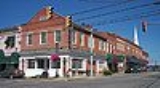
The Barboursville Historic District
was listed on the National Register of Historic Places
in 2008. The Thornburg House
was separately listed in 1991.
Barboursville is located at 38°24′40"N 82°17′52"W (38.411002, -82.297758).
According to the United States Census Bureau
, the village has a total area of 3.8 square miles (9.7 km²), of which, 3.7 square miles (9.5 km²) of it is land and 0.1 square miles (0.2 km²) of it (1.86%) is water.
The confluence of the Mud River
and the Guyandotte River
is just north of the village.
Barboursville, WV, was established in 1813.
Cabell County, West Virginia
As of the census of 2000, there were 96,784 people, 41,180 households, and 25,490 families residing in the county. The population density was 344 people per square mile . There were 45,615 housing units at an average density of 162 per square mile...
, West Virginia
West Virginia
West Virginia is a state in the Appalachian and Southeastern regions of the United States, bordered by Virginia to the southeast, Kentucky to the southwest, Ohio to the northwest, Pennsylvania to the northeast and Maryland to the east...
, United States
United States
The United States of America is a federal constitutional republic comprising fifty states and a federal district...
. It is located near the second largest city in the state, Huntington
Huntington, West Virginia
Huntington is a city in Cabell and Wayne counties in the U.S. state of West Virginia, along the Ohio River. Most of the city is in Cabell County, for which it is the county seat. A small portion of the city, mainly the neighborhood of Westmoreland, is in Wayne County. Its population was 49,138 at...
. The population was 3,183 at the 2000 census.
Barboursville is a part of the Huntington
Huntington, West Virginia
Huntington is a city in Cabell and Wayne counties in the U.S. state of West Virginia, along the Ohio River. Most of the city is in Cabell County, for which it is the county seat. A small portion of the city, mainly the neighborhood of Westmoreland, is in Wayne County. Its population was 49,138 at...
-Ashland
Ashland, Kentucky
Ashland, formerly known as Poage Settlement, is a city in Boyd County, Kentucky, United States, nestled along the banks of the Ohio River. The population was 21,981 at the 2000 census. Ashland is a part of the Huntington-Ashland, WV-KY-OH, Metropolitan Statistical Area . As of the 2000 census, the...
, WV
West Virginia
West Virginia is a state in the Appalachian and Southeastern regions of the United States, bordered by Virginia to the southeast, Kentucky to the southwest, Ohio to the northwest, Pennsylvania to the northeast and Maryland to the east...
-KY
Kentucky
The Commonwealth of Kentucky is a state located in the East Central United States of America. As classified by the United States Census Bureau, Kentucky is a Southern state, more specifically in the East South Central region. Kentucky is one of four U.S. states constituted as a commonwealth...
-OH
Ohio
Ohio is a Midwestern state in the United States. The 34th largest state by area in the U.S.,it is the 7th‑most populous with over 11.5 million residents, containing several major American cities and seven metropolitan areas with populations of 500,000 or more.The state's capital is Columbus...
Metropolitan Statistical Area (MSA). As of the 2000 census, the MSA had a population of 288,649.
The Barboursville Historic District
Barboursville Historic District
Barboursville Historic District is a national historic district located at Barboursville, Cabell County, West Virginia. The district encompasses 20 contributing buildings in the central business district of Barboursville and mostly contains several good examples of late 19th and early 20th century...
was listed on the National Register of Historic Places
National Register of Historic Places
The National Register of Historic Places is the United States government's official list of districts, sites, buildings, structures, and objects deemed worthy of preservation...
in 2008. The Thornburg House
Thornburg House
Thornburg House is a historic home located at Barboursville, Cabell County, West Virginia. It was built in 1901, and is a two story brick and frame dwelling with irregular massing, varied roof shapes, and large porches in the Queen Anne style. It features a corner turret with a pointed roof and a...
was separately listed in 1991.
Barboursville is located at 38°24′40"N 82°17′52"W (38.411002, -82.297758).
According to the United States Census Bureau
United States Census Bureau
The United States Census Bureau is the government agency that is responsible for the United States Census. It also gathers other national demographic and economic data...
, the village has a total area of 3.8 square miles (9.7 km²), of which, 3.7 square miles (9.5 km²) of it is land and 0.1 square miles (0.2 km²) of it (1.86%) is water.
The confluence of the Mud River
Mud River (West Virginia)
The Mud River is a tributary of the Guyandotte River in southwestern West Virginia in the United States. Via the Guyandotte and Ohio Rivers, it is part of the Mississippi River watershed...
and the Guyandotte River
Guyandotte River
The Guyandotte River is a tributary of the Ohio River, approximately 166 mi long, in southwestern West Virginia in the United States. It was named after the French term for the Wendat Native Americans...
is just north of the village.
Barboursville, WV, was established in 1813.