The
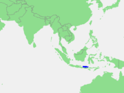
Bali Sea is the body of water north of the island of
BaliBali is an Indonesian island located in the westernmost end of the Lesser Sunda Islands, lying between Java to the west and Lombok to the east...
and south of Kangean Island in
IndonesiaIndonesia , officially the Republic of Indonesia , is a country in Southeast Asia and Oceania. Indonesia is an archipelago comprising approximately 13,000 islands. It has 33 provinces with over 238 million people, and is the world's fourth most populous country. Indonesia is a republic, with an...
. The sea forms the south-west part of the
Flores SeaThe Flores Sea covers 93,000 square miles of water in Indonesia.- Geography :The seas that border the Flores Sea are the Bali Sea , Java Sea , and the Banda Sea ....
, and the
Madura StraitMadura Strait is a stretch of water that separates the Indonesian islands of Java and Madura. The islands of Kambing, Giliraja, Genteng, and Ketapang lie in the Strait....
opens into it from the west.
Geography
The Bali Sea is sometimes grouped with Flores Sea for oceanographic purposes, however in some
nautical chartA nautical chart is a graphic representation of a maritime area and adjacent coastal regions. Depending on the scale of the chart, it may show depths of water and heights of land , natural features of the seabed, details of the coastline, navigational hazards, locations of natural and man-made aids...
s, Bali Sea is written as a distinct sea for navigation. The sea has an area of 45000 km² (17,374.6 sq mi) and a maximum depth of 1590 m (5,217 ft).
Extent
The
International Hydrographic OrganizationThe International Hydrographic Organization is the inter-governmental organisation representing the hydrographic community. It enjoys observer status at the UN and is the recognised competent authority on hydrographic surveying and nautical charting...
(IHO) defines the Bali Sea as being one of the waters of the
East Indian ArchipelagoThe East Indian Archipelago is a marine area designated by the International Hydrographic Organization . It consists of a number of seas and straits in the East Indies ....
. The IHO defines its limits as follows:
On the North. A line from the Western Paternoster Island to the East point of Sepandjang and thence through this island to the West point of Gedeh Bay on the South coast of Kangean (7°01′S 115°18′E).
On the West. A line from the West point of Gedeh Bay, Kangean Island, to Tg Sedano, the Northeast extreme of JavaJava is an island of Indonesia. With a population of 135 million , it is the world's most populous island, and one of the most densely populated regions in the world. It is home to 60% of Indonesia's population. The Indonesian capital city, Jakarta, is in west Java...
and down the East coast to Tg Bantenan, the Southeast extreme of the island.
On the South. A line from Tanjong Banenan through the Southern points of Balt and NoesaNusa Penida is an island southeast of Bali island, Indonesia. Administratively, the island is a district of Klungkung regency. There are two small islands nearby: Nusa Lembongan and Nusa Ceningan. The Badung Strait separates the island and Bali. The interior of Nusa Penida is hilly with a maximum...
Islands to Tanjong Bt Gendang, the Southwest extreme of LombokLombok is an island in West Nusa Tenggara province, Indonesia. It forms part of the chain of the Lesser Sunda Islands, with the Lombok Strait separating it from Bali to the west and the Alas Strait between it and Sumbawa to the east...
, and its South coast to Tanjong Ringgit the Southeast extreme, thence a line to Tanjong Mangkoen (9°01′S 116°43′E) the Southwest extreme of SoembawaSumbawa is an Indonesian island, located in the middle of the Lesser Sunda Islands chain, with Lombok to the west, Flores to the east, and Sumba further to the southeast. It is in the province of West Nusa Tenggara....
.
On the East. The West and North coasts of Soembawa as far East as Tanjong Sarokaja (8°22′S 117°10′E), thence the Western limit of Flores Sea [A line from Tg Sarokaja to the Western Paternoster island (7°26′S 117°08′E)].
Circulation
The circulation and mass water properties in Bali Sea are a continuation from Flores Sea to the
Java SeaThe Java Sea is a large shallow sea on the Sunda Shelf. It was formed as sea levels rose at the end of the last ice age. The Java Sea lies between the Indonesian islands of Borneo to the north, Java to the south; Sumatra to the west, and Sulawesi to the east...
in the north. In oceanographic, Bali Sea is concerned with the
Indonesian ThroughflowThe Indonesian throughflow is important to global climate since it provides a low-latitude pathway for warm, fresh water to move from the Pacific to the Indian Ocean and this serves as the upper branch of the Pacific-Indian overturning circulation global heat conveyor belt...
coming from
Pacific OceanThe Pacific Ocean is the largest of the Earth's oceanic divisions. It extends from the Arctic in the north to the Southern Ocean in the south, bounded by Asia and Australia in the west, and the Americas in the east.At 165.2 million square kilometres in area, this largest division of the World...
to the
Indian OceanThe Indian Ocean is the third largest of the world's oceanic divisions, covering approximately 20% of the water on the Earth's surface. It is bounded on the north by the Indian Subcontinent and Arabian Peninsula ; on the west by eastern Africa; on the east by Indochina, the Sunda Islands, and...
, the flow of which are mostly passing through
Bali StraitBali Strait is a 2.4 kilometer strait between the Indonesian islands of Bali and Java....
and
Lombok StraitThe Lombok Strait is a strait connecting the Java Sea to the Indian Ocean, located between the islands of Bali and Lombok in Indonesia. The Gili Islands are on the Lombok side....
.
Tsunamis
In a recorded
tsunamiA tsunami is a series of water waves caused by the displacement of a large volume of a body of water, typically an ocean or a large lake...
history, Bali Sea observed several tsunamis. The
1815 Tambora eruptionMount Tambora is an active stratovolcano, also known as a composite volcano, on the island of Sumbawa, Indonesia. Sumbawa is flanked both to the north and south by oceanic crust, and Tambora was formed by the active subduction zone beneath it. This raised Mount Tambora as high as , making it...
(scale 7 of
Volcanic Explosivity IndexThe Volcanic Explosivity Index was devised by Chris Newhall of the U.S. Geological Survey and Stephen Self at the University of Hawaii in 1982 to provide a relative measure of the explosiveness of volcanic eruptions....
) formed tsunamis on 22 September 1815 at coordinate 8.00°N 115.20°W and three years later (8 September 1818) from subsequent volcanic activities at coordinate 7.0°N 117.0°W. Two more tsunamis were recorded in 1857 and 1917 with maximum height of 3 metres (9.8 ft) and 2 metres (6.6 ft) respectively.
The source of this article is
wikipedia, the free encyclopedia. The text of this article is licensed under the
GFDL.