

Ayeyarwady Division
Encyclopedia
Ayeyarwady Region is a region of Myanmar
, occupying the delta region of the Ayeyarwady River
(Irrawaddy River). It is bordered by Bago Region to the north, Bago Region and Yangon Region to the east, and the Bay of Bengal
to the south and west. It is contiguous with the Rakhine State
in the northwest.
The region lies between north latitude 15° 40' and 18° 30' approximately and between cast longitude 94° 15' and 96° 15'. It has an area of 13566 square miles (35,135.8 km²). The population is over 6.5 million, making it the most populous of Burma’s states and regions. The population density is 466 pd/sqmi.
Ayeyarwady Region is flanked by the Rakhine Yoma
(Arakan Mountains) range in the west and large areas were cleared for paddy cultivation, leading to its preeminent position as the main rice producer in the country, a position it has retained into the 21st century.
It has also a number of lakes. Of the rivers branching out from the mighty Ayeyarwady
, Ngawun, Pathein and Toe are famous.
The capital city of Ayeyawady division is Pathein
.
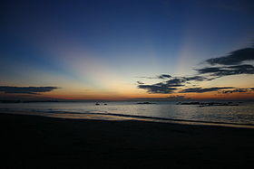
Chaungtha Beach and Ngwesaung Beach are popular resorts for both foreigners and Burma people.
They are located in west side of Ayewarwaddy Region, one hours distance from Pathein
city and four hours from Yangon
city by road transportation.
and Karen
form the majority of the population, with a small minority of Rakhine
in western coastal regions. The majority of the people are Buddhist, with small minorities of Christians and Muslims. Burmese
is the lingua franca.
 Ayeyarwady Region is heavily forested and wood products are an important component of the economy. The principal crop of Ayeyarwady Region is rice
, and the division is called the “granary of Burma.” In addition to rice, other crops include maize
, sesame
, groundnut
, sunflower
, beans, pulses, and jute
. Fishery is also important; Ayeyarwady Region produces fish, prawn
, fish-paste, dry fish, dry prawn, and fish sauce.
Ayeyarwady Region also has considerable tourist potential. The city of Pathein
has numerous historic sights and temples. Outside Pathein are the beach resorts of Chaungtha Beach and the lake resort of Inye Lake. Inye lake is located in Kyonpyaw
township, 59 miles (95 km) north east of Pathein. Inye lake is also well-known for fishery, as the major supplier of fresh water fish. Chaungtha is located in Pathein township. However, hotel and transportation infrastructure
is still very poorly developed.
) rule from the 11th century AD. Its subsequent history mirrors that of the rest of lower Burma.
made landfall in 2008
.
Burma's state-controlled news media reported that Nargis left more than 66,000 people dead or missing after it struck the Irrawaddy Delta region May 2, unleashing torrential rains, 120 mph sustained winds and a 12 feet (3.7 m) tidal wave. Foreign relief official and diplomats have said the death toll could exceed 100,000.
Labutta District was formed in August 2008, three months after Cyclone Nagis hit the region.
Pathein
is the principal city and capital. It consists of 26 townships and 29 cities. In the townships there are 219 wards, 1912 village groups and 11651 villages.
and Mandalay
. According to official statistics, less than 10% of primary school students in the division reach high school.
Pathein University is the main university in the state, and until recently the only four-year university in the state. In recent years, the military government
, which closed down universities and colleges in the 1990s to quell student unrest, has "upgraded" former colleges and two-year institutes. The government now requires that students attend their local universities and colleges, such as Hinthada University and Maubin University.
Myanmar
Burma , officially the Republic of the Union of Myanmar , is a country in Southeast Asia. Burma is bordered by China on the northeast, Laos on the east, Thailand on the southeast, Bangladesh on the west, India on the northwest, the Bay of Bengal to the southwest, and the Andaman Sea on the south....
, occupying the delta region of the Ayeyarwady River
Ayeyarwady River
The Irrawaddy River or Ayeyarwady River is a river that flows from north to south through Burma . It is the country's largest river and most important commercial waterway. Originating from the confluence of the N'mai and Mali rivers, it flows relatively straight North-South before emptying through...
(Irrawaddy River). It is bordered by Bago Region to the north, Bago Region and Yangon Region to the east, and the Bay of Bengal
Bay of Bengal
The Bay of Bengal , the largest bay in the world, forms the northeastern part of the Indian Ocean. It resembles a triangle in shape, and is bordered mostly by the Eastern Coast of India, southern coast of Bangladesh and Sri Lanka to the west and Burma and the Andaman and Nicobar Islands to the...
to the south and west. It is contiguous with the Rakhine State
Rakhine State
Rakhine State is a Burmese state. Situated on the western coast, it is bordered by Chin State in the north, Magway Region, Bago Region and Ayeyarwady Region in the east, the Bay of Bengal to the west, and the Chittagong Division of Bangladesh to the northwest. It is located approximately between...
in the northwest.
The region lies between north latitude 15° 40' and 18° 30' approximately and between cast longitude 94° 15' and 96° 15'. It has an area of 13566 square miles (35,135.8 km²). The population is over 6.5 million, making it the most populous of Burma’s states and regions. The population density is 466 pd/sqmi.
Ayeyarwady Region is flanked by the Rakhine Yoma
Arakan Yoma
The Arakan Mountains is a mountain range in western Burma , between the coast of Rakhine State and the Central Burma Basin, in which flows the Irrawaddy River...
(Arakan Mountains) range in the west and large areas were cleared for paddy cultivation, leading to its preeminent position as the main rice producer in the country, a position it has retained into the 21st century.
It has also a number of lakes. Of the rivers branching out from the mighty Ayeyarwady
Ayeyarwady River
The Irrawaddy River or Ayeyarwady River is a river that flows from north to south through Burma . It is the country's largest river and most important commercial waterway. Originating from the confluence of the N'mai and Mali rivers, it flows relatively straight North-South before emptying through...
, Ngawun, Pathein and Toe are famous.
The capital city of Ayeyawady division is Pathein
Pathein
Pathein , also called Bassein, is a port city with a 2004 population estimated at 215,600, and the capital of the Ayeyarwady Region, Burma. It lies on the Pathein River , which is a western branch of the Irrawaddy River....
.
Chaungtha Beach and Ngwesaung Beach are popular resorts for both foreigners and Burma people.
They are located in west side of Ayewarwaddy Region, one hours distance from Pathein
Pathein
Pathein , also called Bassein, is a port city with a 2004 population estimated at 215,600, and the capital of the Ayeyarwady Region, Burma. It lies on the Pathein River , which is a western branch of the Irrawaddy River....
city and four hours from Yangon
Yangon
Yangon is a former capital of Burma and the capital of Yangon Region . Although the military government has officially relocated the capital to Naypyidaw since March 2006, Yangon, with a population of over four million, continues to be the country's largest city and the most important commercial...
city by road transportation.
Demographics
BamarBamar
The Bamar are the dominant ethnic group of Burma , constituting approximately two-thirds of the population. The Bamar live primarily in the Irrawaddy basin, and speak the Burmese language, which is also the official language of Burma. Bamar customs and identity are closely intertwined with general...
and Karen
Karen people
The Karen or Kayin people , are a Sino-Tibetan language speaking ethnic group which resides primarily in southern and southeastern Burma . The Karen make up approximately 7 percent of the total Burmese population of approximately 50 million people...
form the majority of the population, with a small minority of Rakhine
Rakhine people
The Rakhine , is a nationality in Myanmar forming the majority along the coastal region of present day Rakhine State or Arakan State. They possibly constitute 5.53% or more of Myanmar's total population but no accurate census figures exist. Rakhine people also live in the southeastern parts of...
in western coastal regions. The majority of the people are Buddhist, with small minorities of Christians and Muslims. Burmese
Burmese language
The Burmese language is the official language of Burma. Although the constitution officially recognizes it as the Myanmar language, most English speakers continue to refer to the language as Burmese. Burmese is the native language of the Bamar and related sub-ethnic groups of the Bamar, as well as...
is the lingua franca.
Economy
Rice
Rice is the seed of the monocot plants Oryza sativa or Oryza glaberrima . As a cereal grain, it is the most important staple food for a large part of the world's human population, especially in East Asia, Southeast Asia, South Asia, the Middle East, and the West Indies...
, and the division is called the “granary of Burma.” In addition to rice, other crops include maize
Maize
Maize known in many English-speaking countries as corn or mielie/mealie, is a grain domesticated by indigenous peoples in Mesoamerica in prehistoric times. The leafy stalk produces ears which contain seeds called kernels. Though technically a grain, maize kernels are used in cooking as a vegetable...
, sesame
Sesame
Sesame is a flowering plant in the genus Sesamum. Numerous wild relatives occur in Africa and a smaller number in India. It is widely naturalized in tropical regions around the world and is cultivated for its edible seeds, which grow in pods....
, groundnut
Peanut
The peanut, or groundnut , is a species in the legume or "bean" family , so it is not a nut. The peanut was probably first cultivated in the valleys of Peru. It is an annual herbaceous plant growing tall...
, sunflower
Sunflower
Sunflower is an annual plant native to the Americas. It possesses a large inflorescence . The sunflower got its name from its huge, fiery blooms, whose shape and image is often used to depict the sun. The sunflower has a rough, hairy stem, broad, coarsely toothed, rough leaves and circular heads...
, beans, pulses, and jute
Jute
Jute is a long, soft, shiny vegetable fibre that can be spun into coarse, strong threads. It is produced from plants in the genus Corchorus, which has been classified in the family Tiliaceae, or more recently in Malvaceae....
. Fishery is also important; Ayeyarwady Region produces fish, prawn
Prawn
Prawns are decapod crustaceans of the sub-order Dendrobranchiata. There are 540 extant species, in seven families, and a fossil record extending back to the Devonian...
, fish-paste, dry fish, dry prawn, and fish sauce.
Ayeyarwady Region also has considerable tourist potential. The city of Pathein
Pathein
Pathein , also called Bassein, is a port city with a 2004 population estimated at 215,600, and the capital of the Ayeyarwady Region, Burma. It lies on the Pathein River , which is a western branch of the Irrawaddy River....
has numerous historic sights and temples. Outside Pathein are the beach resorts of Chaungtha Beach and the lake resort of Inye Lake. Inye lake is located in Kyonpyaw
Kyonpyaw
Kyonpyaw is a town in the Ayeyawady Division of Myanmar. It is the seat of Kyonpyaw Township.-External links:*...
township, 59 miles (95 km) north east of Pathein. Inye lake is also well-known for fishery, as the major supplier of fresh water fish. Chaungtha is located in Pathein township. However, hotel and transportation infrastructure
Infrastructure
Infrastructure is basic physical and organizational structures needed for the operation of a society or enterprise, or the services and facilities necessary for an economy to function...
is still very poorly developed.
History
The Ayeyarwady delta region was traditionally part of the Mon kingdom. This area fell under Burmese (and occasional RakhineRakhine people
The Rakhine , is a nationality in Myanmar forming the majority along the coastal region of present day Rakhine State or Arakan State. They possibly constitute 5.53% or more of Myanmar's total population but no accurate census figures exist. Rakhine people also live in the southeastern parts of...
) rule from the 11th century AD. Its subsequent history mirrors that of the rest of lower Burma.
Cyclone Nargis
The area was the site of heavy devastation when Cyclone NargisCyclone Nargis
Cyclone Nargis , was a strong tropical cyclone that caused the worst natural disaster in the recorded history of Burma. The cyclone made landfall in Burma on Friday, May 2, 2008, causing catastrophic destruction and at least 138,000 fatalities...
made landfall in 2008
2008 North Indian Ocean cyclone season
The 2008 North Indian cyclone season was an ongoing event in the annual cycle of tropical cyclone formation. The North Indian cyclone season has no official bounds, but cyclones tend to form between April and December, with peaks in May and November...
.
Burma's state-controlled news media reported that Nargis left more than 66,000 people dead or missing after it struck the Irrawaddy Delta region May 2, unleashing torrential rains, 120 mph sustained winds and a 12 feet (3.7 m) tidal wave. Foreign relief official and diplomats have said the death toll could exceed 100,000.
Administration
Ayeyarwady Region consists of six districts:- Pathein DistrictPathein DistrictPathein District is a district of Ayeyawady Division, Myanmar. It is located around the city of Pathein and includes the urban area of it. The area of the Pathein District is 10900 km²...
- Hinthada DistrictHinthada District-Townships:The district contains the following townships:*Hinthada Township*Zalun Township*Laymyethna Township*Myanaung Township*Kyangin Township*Ingapu Township...
- Myaungmya DistrictMyaungmya DistrictMyaungmya District is a district of the Ayeyarwady Division in south western Myanmar. It consists 5 cities. They are Myaungmya.Myaungmya district was formed in 1893 out of a portion of Bassein district, and reconstituted until 1903. It has an area of and a population of 280,000 and density of 104...
- Maubin DistrictMaubin DistrictMaubin District is a district of the Ayeyarwady Division in south western Myanmar. It contains 4 cities: Maubin, Pantanaw, Nyaungdon, and Danubyu.-Townships:The district contains the following townships:*Maubin Township*Pantanaw Township...
- Pyapon DistrictPyapon DistrictPyapon District is a district of the Ayeyarwady Division in south western Myanmar. It consists 4 cities. They are Pyapon, Bogalay, Kyaiklat and Dedaye.-Townships:The district contains the following townships:*Pyapon Township*Bogalay Township...
- Labutta DistrictLabutta DistrictLabutta District or Latputta District is a district in Ayeyarwady Region, Myanmar. Labutta District was established in 2008 after the region was hit by Cyclone Nargis in May 2008. The administrative seat is the town of Labutta .-Townships:...
Labutta District was formed in August 2008, three months after Cyclone Nagis hit the region.
Pathein
Pathein
Pathein , also called Bassein, is a port city with a 2004 population estimated at 215,600, and the capital of the Ayeyarwady Region, Burma. It lies on the Pathein River , which is a western branch of the Irrawaddy River....
is the principal city and capital. It consists of 26 townships and 29 cities. In the townships there are 219 wards, 1912 village groups and 11651 villages.
Bridges
- Bo Myat Tun Bridge (Nyaungdon)
- Daydalu Bridge (Pyapon)
- Dedaye BridgeDedaye BridgeDedaye Bridge , also known as the Ayeyarwady-Dedaye Bridge is a bridge linking Kungyangon Township in Yangon Division and Dedaye Township in Ayeyawady Division in southern Burma. It crosses the Ayeyawady River....
(Kungyangon TownshipKungyangon TownshipKungyangon Township is a township of Yangon Region. It is located in the southwestern part of the Region, by the Andaman Sea....
in Yangon Region and Dedaye TownshipDedaye TownshipDedaye Township is a township of Pyapon District in the Ayeyarwady Region of Myanmar....
in Ayeyawady Region) - Gonnhindan Bridge
- Khattiya Bridge (Maubin)
- Kyauk Chaung Gyi Bridge (Pathein)
- Kyungon BridgeKyungon BridgeThe Kyungon Bridge is a bridge on the Wakema–Kyungon–Myinkaseik–Pathein Road across the Pyamalaw River between Wakema Township and Einme Township in Ayeyawady Region of Burma...
- Labutta Bridge
- Maubin Bridge (Maubin)
- Maung Bi Wa Bridge (Pathein)
- Mayan Ngu Bridge (Myaungmya)
- Myaungmya Bridge (Myaungmya)
- Natchaung Bridge (Bogalay)
- Nga Wun Bridge (Myokwin)(Ingapu)
- Ngathaingchaung Bridge
- Pinlelay Bridge
- Seikma Bridge (Bogalay)
- Shwelaung Bridge
- Thegon BridgeThegon BridgeThekon Bridge is a bridge linking Kyaunggon Township and Kangyidaunk Township on Yangon-Pathein Road in the Ayeyawady Division of Burma. It opened on Monday, 12 August 2001 The Thekon Bridge was built in 10 months. It was built at a cost of over K 155 million. The bridge is 300 feet long and 28...
(Kyaunggon Township and Kangyidaunk Township) - Uto Bridge
- Wakema Bridge
Education
Educational opportunities in Myanmar are extremely limited outside the main cities of YangonYangon
Yangon is a former capital of Burma and the capital of Yangon Region . Although the military government has officially relocated the capital to Naypyidaw since March 2006, Yangon, with a population of over four million, continues to be the country's largest city and the most important commercial...
and Mandalay
Mandalay
Mandalay is the second-largest city and the last royal capital of Burma. Located north of Yangon on the east bank of the Irrawaddy River, the city has a population of one million, and is the capital of Mandalay Region ....
. According to official statistics, less than 10% of primary school students in the division reach high school.
| AY 2002-2003 | Primary | Middle | High |
|---|---|---|---|
| Schools | 5623 | 270 | 102 |
| Teachers | 17,600 | 5700 | 1800 |
| Students | 708,000 | 181,000 | 61,000 |
Pathein University is the main university in the state, and until recently the only four-year university in the state. In recent years, the military government
State Peace and Development Council
The State Peace and Development Council was the official name of the military regime of Burma , which seized power in 1988. On 30 March 2011, Senior General Than Shwe signed a decree to officially dissolve the Council....
, which closed down universities and colleges in the 1990s to quell student unrest, has "upgraded" former colleges and two-year institutes. The government now requires that students attend their local universities and colleges, such as Hinthada University and Maubin University.
Health care
The general state of health care in Myanmar is poor. The military government spends anywhere from 0.5% to 3% of the country's GDP on health care, consistently ranking among the lowest in the world. Although health care is nominally free, in reality, patients have to pay for medicine and treatment, even in public clinics and hospitals. Public hospitals lack many of the basic facilities and equipment. Moreover, the health care infrastructure outside of Yangon and Mandalay is extremely poor. For example, in 2003, Ayeyarwady Region had less than a quarter of hospital beds than Yangon Region although Ayeyarwady Region had a slightly greater population.External links
| 2002–2003 | # Hospitals | # Beds |
|---|---|---|
| Specialist hospitals | 0 | 0 |
| General hospitals with specialist services | 2 | 450 |
| General hospitals | 24 | 910 |
| Health clinics | 45 | 720 |
| Total | 71 | 2080 |