

Avenida de los Insurgentes
Encyclopedia
Street name
A street name or odonym is an identifying name given to a street. The street name usually forms part of the address...
in Mexico City
Mexico City
Mexico City is the Federal District , capital of Mexico and seat of the federal powers of the Mexican Union. It is a federal entity within Mexico which is not part of any one of the 31 Mexican states but belongs to the federation as a whole...
and said to be the longest in the world with a length of 28.8 km (17.9 mi) on a north-south axis across the city. Insurgentes has its origins in what was during the early 20th century known as the Via del Centenario which ran from city centre to the southern suburbs.
Many decades later, after it was paved
Pavement (material)
Road surface or pavement is the durable surface material laid down on an area intended to sustain vehicular or foot traffic, such as a road or walkway. In the past cobblestones and granite setts were extensively used, but these surfaces have mostly been replaced by asphalt or concrete. Such...
and widened, its name was changed to Avenida de los Insurgentes, apparently happening during the administration of President
President of Mexico
The President of the United Mexican States is the head of state and government of Mexico. Under the Constitution, the president is also the Supreme Commander of the Mexican armed forces...
Miguel Alemán
Miguel Alemán Valdés
Miguel Alemán Valdés served as the President of Mexico from 1946 to 1952.-Life:Alemán was born in Sayula in the state of Veracruz as the son of General Miguel Alemán González and Tomasa Valdés Ledezma...
, when the area attracted wealthy urbanites for sophisticated, modern housing.
The avenue was named after the Insurgent Army (Ejército de los Insurgentes) that fought for Mexican independence from Spain
Spain
Spain , officially the Kingdom of Spain languages]] under the European Charter for Regional or Minority Languages. In each of these, Spain's official name is as follows:;;;;;;), is a country and member state of the European Union located in southwestern Europe on the Iberian Peninsula...
during the Mexican War of Independence
Mexican War of Independence
The Mexican War of Independence was an armed conflict between the people of Mexico and the Spanish colonial authorities which started on 16 September 1810. The movement, which became known as the Mexican War of Independence, was led by Mexican-born Spaniards, Mestizos and Amerindians who sought...
from 1810 to 1821.
The avenue's southern terminus is located near Volcán Ajusco in the intersection with the Viaducto Tlalpan avenue, where it becomes Highway 95
Mexican Federal Highway 95
Mexican Federal Highway 95 connects Mexico City to Acapulco, Guerrero.The highway is the main road that leads to the Lagunas de Zempoala National Park...
in direction to Cuernavaca
Cuernavaca
Cuernavaca is the capital and largest city of the state of Morelos in Mexico. It was established at the archeological site of Gualupita I by the Olmec, "the mother culture" of Mesoamerica, approximately 3200 years ago...
. The northern terminus is located in the intersection with Avenida Acueducto where it becomes the highway to Pachuca
Pachuca
Pachuca, formally Pachuca de Soto is the capital of the Mexican state of Hidalgo. It is located in the south-central part of the state. Pachuca de Soto is also the name of the municipality of which the city serves as municipal seat...
.
The avenue crosses five of the 16 boroughs of the city. Many of Mexico City's emblematic colonias (such as Condesa
Condesa
Officially, Colonia Condesa is an administrative division or “colonia” located west of the historic center of Mexico City, just south of Avenida Chapultepec. Popularly, the name “La Condesa” is named after the second, the María Magdalena Dávalos de Bracamontes y Orozco, the Countess of Miravalle,...
, Roma
Colonia Roma
Colonia Roma is a colonia or neighborhood located in the Cuauhtémoc borough of Mexico City just west of the city’s historic center. The area was a very shallow part of Lake Texcoco, dotted with tiny islands and one small island village of Aztacalco during the pre-Hispanic period...
, Del Valle
Colonia del Valle
Colonia del Valle is a neighborhood in the Benito Juarez borough of Mexico City. The city includes "...a great number of parks, vast and tree-lined streets, prestigious shopping malls, and some city landmarks..."...
, Napoles
Colonia del Valle
Colonia del Valle is a neighborhood in the Benito Juarez borough of Mexico City. The city includes "...a great number of parks, vast and tree-lined streets, prestigious shopping malls, and some city landmarks..."...
, San Ángel
San Ángel
San Ángel is a colonia or neighborhood of Mexico City, located in the southwest in Álvaro Óbregon borough. Historically, it was a rural community, called Tenanitla in the pre Hispanic period. Its current name is derived from the El Carmen monastery school called San Ángel Mártir...
, Pedregal
El Pedregal
El Pedregal is a municipality located in the province of Guadalajara, Castile-La Mancha, Spain. According to the 2004 census , the municipality has a population of 106 inhabitants....
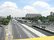
) are either crossed or on the side of Insurgentes. The Mexico City Metrobús
Mexico City Metrobús
Metrobús is a bus rapid transit system in Mexico City, Mexico. It comprises 3 lines that traverse the city and connect with other forms of transit. It was officially opened to the public with service along Line 1 on 19 June 2005...
bus rapid transit
Bus rapid transit
Bus rapid transit is a term applied to a variety of public transportation systems using buses to provide faster, more efficient service than an ordinary bus line. Often this is achieved by making improvements to existing infrastructure, vehicles and scheduling...
system, opened in 2005, runs through the avenue, from Tlalpan
Tlalpan
Tlalpan is one of the sixteen administrative boroughs of the Federal District of Mexico City. It is the largest borough, with over eighty percent under conservation as forest and other ecologically sensitive area. The rest, almost all of it on the northern edge, has been urban since the mid 20th...
to Metro Indios Verdes
Metro Indios Verdes
Indios Verdes is a station on the Mexico City Metro. Indios Verdes, located in the northern reaches of Mexico City, is the current terminal station for the Metro's Line 3.Indios Verdes literally means "Green Indians"...
.
Notable locations
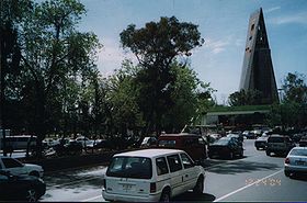
- World Trade Center MéxicoWorld Trade Center MéxicoThe World Trade Center Mexico City is a building complex located in Mexico City, Mexico. Its most famous and recognizable feature is the 52-story, 207m high Torre WTC, the third tallest building in Mexico City , or fourth when measured by its 191m roof height...
- The World Trade CenterWorld Trade CenterThe original World Trade Center was a complex with seven buildings featuring landmark twin towers in Lower Manhattan, New York City, United States. The complex opened on April 4, 1973, and was destroyed in 2001 during the September 11 attacks. The site is currently being rebuilt with five new...
of Mexico. It's located next to the Polyforum Cultural SiqueirosPolyforum Cultural SiqueirosThe Polyforum Cultural Siqueiros is a cultural, political and social facility located in Mexico City as part of the World Trade Center Mexico City...
. It is one of the tallest buildings in the city with 52 floors. It has its own conference center and shopping mall.
- Teatro de los InsurgentesTeatro de los InsurgentesTeatro de los Insurgentes is a theater located on Mexico City's Avenida de los Insurgentes.It was built by José María Dávila in 1953 as part of President Miguel Alemán's program of urban renewal. Dávila commissioned muralist Diego Rivera to paint La historia del teatro, a visual history of the...
(Insurgents' Theater)
- Important theater built in 1953 by José María Dávila
- Ciudad Universitaria (C.U.)National Autonomous University of MexicoThe Universidad Nacional Autónoma de México is a university in Mexico. UNAM was founded on 22 September 1910 by Justo Sierra as a liberal alternative to the Roman Catholic-sponsored Royal and Pontifical University of Mexico The Universidad Nacional Autónoma de México (UNAM) (National Autonomous...
- Is the campus of the National Autonomous University of MexicoNational Autonomous University of MexicoThe Universidad Nacional Autónoma de México is a university in Mexico. UNAM was founded on 22 September 1910 by Justo Sierra as a liberal alternative to the Roman Catholic-sponsored Royal and Pontifical University of Mexico The Universidad Nacional Autónoma de México (UNAM) (National Autonomous...
. The speed limit in this zone is 40 mph.
- CuicuilcoCuicuilcoCuicuilco is an important archaeological Mesoamerican Middle and Late Formative period site located on the southern shore of the Lake Texcoco in the southeastern Valley of Mexico. Today, it is a significant archaeological site that was occupied during the Early Formative until its destruction in...
archaeological area
- It was the ancient village of the Cuicuilcas who used to live in what is today southern part of the city, just 1 km away from the campus. Xitle Volcano destroyed the city circa 1100BC. It remains the Imán pyramidPyramidA pyramid is a structure whose outer surfaces are triangular and converge at a single point. The base of a pyramid can be trilateral, quadrilateral, or any polygon shape, meaning that a pyramid has at least three triangular surfaces...
.
There are several shopping malls located along the avenue, including Perisur
Perisur
Perisur is a shopping mall located in the Coyoacán borough in southern Mexico City at the intersection of Insurgentes Avenue South and the Anillo Periférico, next to the UNAM main campus in Ciudad Universitaria and to the upscale Jardines del Pedregal neighbourhood...
, Galerias Insurgentes
Colonia del Valle
Colonia del Valle is a neighborhood in the Benito Juarez borough of Mexico City. The city includes "...a great number of parks, vast and tree-lined streets, prestigious shopping malls, and some city landmarks..."...
and Centro Insurgentes.
Throughout its span, Insurgentes crosses several ejes viales as well as the Circuito Interior and Anillo Periférico
Anillo Periférico
The Anillo Periférico is the name given to the outer beltway of Mexico City. The beltway gained major media attention when the Mexico City mayor, Andrés Manuel López Obrador, started a project to turn a southern section of the ring into a two-story highway...
highway rings twice.