

Australian Shield
Encyclopedia
Shield (geology)
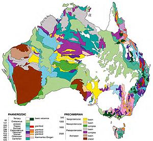
A shield is generally a large area of exposed Precambrian crystalline igneous and high-grade metamorphic rocks that form tectonically stable areas. In all cases, the age of these rocks is greater than 570 million years and sometimes dates back 2 to 3.5 billion years...
or Western Plateau
Western Plateau
The Western Plateau is Australia's largest drainage division and is composed predominantly of the remains of the ancient rock shield of Gondwanaland. It incorporates two thirds of the continent; 2,700,000 square kilometres of arid land including large parts of Western Australia, South Australia,...
, occupies more than half of the continent of Australia
Australia
Australia , officially the Commonwealth of Australia, is a country in the Southern Hemisphere comprising the mainland of the Australian continent, the island of Tasmania, and numerous smaller islands in the Indian and Pacific Oceans. It is the world's sixth-largest country by total area...
. It occupies the portion of Australia west of a line running north-south roughly from the eastern shore of Arnhem Land
Arnhem Land
The Arnhem Land Region is one of the five regions of the Northern Territory of Australia. It is located in the north-eastern corner of the territory and is around 500 km from the territory capital Darwin. The region has an area of 97,000 km² which also covers the area of Kakadu National...
on the Bay or Gulf of Carpentaria
Gulf of Carpentaria
The Gulf of Carpentaria is a large, shallow sea enclosed on three sides by northern Australia and bounded on the north by the Arafura Sea...
to the Eyre Peninsula in the state of South Australia
South Australia
South Australia is a state of Australia in the southern central part of the country. It covers some of the most arid parts of the continent; with a total land area of , it is the fourth largest of Australia's six states and two territories.South Australia shares borders with all of the mainland...
, and skirting to the west of the Simpson Desert
Simpson Desert
The Simpson Desert is a large area of dry, red sandy plain and dunes in Northern Territory, South Australia and Queensland in central Australia. It is the fourth largest Australian desert, with an area of 176,500 km² ....
in the interior. The plateau has an average elevation of between 305 and 460 m (1,000 and 1,500 ft). The shield is fractured into a number of distinct blocks, including the Pilbara craton
Pilbara craton
The Pilbara craton , along with the Kaapvaal craton are the only remaining areas of pristine Archaean 3.6-2.7 Ga crust on Earth...
in the North and the Yilgarn craton
Yilgarn craton
The Yilgarn Craton is a large craton which constitutes the bulk of the Western Australian land mass. It is bounded by a mixture of sedimentary basins and Proterozoic fold and thrust belts...
in the Southwest. Some of these blocks have been raised to form uplands; others have been depressed, forming lowlands and basins. The lowlands include the Great Sandy Desert
Great Sandy Desert
The Great Sandy Desert is a desert located in the North West of Western Australia straddling the Pilbara and southern Kimberley regions. It is the second largest desert in Australia after the Great Victoria Desert and encompasses an area of...
, the Gibson Desert
Gibson Desert
The Gibson Desert covers a large dry area in the state of Western Australia and is still largely in an almost "pristine" state. It is about in size, making it the 5th largest desert in Australia, after the Great Sandy, Great Victoria, Tanami and Simpson deserts.-Location and description:The Gibson...
, the Great Victoria Desert
Great Victoria Desert
The Great Victoria Desert is a barren and sparsely populated desert area of southern Australia.-Location and description:The Great Victoria is the biggest desert in Australia and consists of many small sandhills, grassland plains, areas with a closely packed surface of pebbles and salt lakes...
, and the Nullarbor Plain
Nullarbor Plain
The Nullarbor Plain is part of the area of flat, almost treeless, arid or semi-arid country of southern Australia, located on the Great Australian Bight coast with the Great Victoria Desert to its north. It is the world's largest single piece of limestone, and occupies an area of about...
, which are located in the north-western, central, southern, and south-eastern shield areas respectively. The Nullarbor (from Latin, “no trees”) is an arid, virtually uninhabited limestone plateau. Between the Western Australian Shield and the Great Dividing Range
Great Dividing Range
The Great Dividing Range, or the Eastern Highlands, is Australia's most substantial mountain range and the third longest in the world. The range stretches more than 3,500 km from Dauan Island off the northeastern tip of Queensland, running the entire length of the eastern coastline through...
is the Great Artesian Basin
Great Artesian Basin
The Great Artesian Basin provides the only reliable source of freshwater through much of inland Australia. The basin is the largest and deepest artesian basin in the world, stretching over a total of , with temperatures measured ranging from 30°C to 100°C...
region
The uplands include, in Western Australia
Western Australia
Western Australia is a state of Australia, occupying the entire western third of the Australian continent. It is bounded by the Indian Ocean to the north and west, the Great Australian Bight and Indian Ocean to the south, the Northern Territory to the north-east and South Australia to the south-east...
, the Hamersley and King Leopold ranges in the western and north-western coastal areas, and the Darling Range inland from Perth
Perth, Western Australia
Perth is the capital and largest city of the Australian state of Western Australia and the fourth most populous city in Australia. The Perth metropolitan area has an estimated population of almost 1,700,000....
in the far south-west. The MacDonnell Ranges
MacDonnell Ranges
The MacDonnell Ranges of the Northern Territory, are a long series of mountain ranges located in the centre of Australia , and consist of parallel ridges running to the east and west of Alice Springs...
lie in the southern part of the Northern Territory
Northern Territory
The Northern Territory is a federal territory of Australia, occupying much of the centre of the mainland continent, as well as the central northern regions...
, and the Stuart
Stuart Range
The Stuart Range is a mountain range in central Washington, USA. The range lies within the eastern extent of the Cascade Range immediately southwest of Leavenworth and runs east-west. The western peaks make up a single sharp ridge. The eastern half of the range splits into two parallel ridges,...
and Musgrave Ranges
Musgrave Ranges
Musgrave Ranges is a mountain range in Central Australia, straddling the boundary of South Australia and the Northern Territory , extending into Western Australia. It is between the Great Victoria Desert to the south and the Gibson Desert to the north...
are located in the north of the state of South Australia. Erosion and weathering have created striking, isolated rock formations, called mesa
Mesa
A mesa or table mountain is an elevated area of land with a flat top and sides that are usually steep cliffs. It takes its name from its characteristic table-top shape....
s or butte
Butte
A butte is a conspicuous isolated hill with steep, often vertical sides and a small, relatively flat top; it is smaller than mesas, plateaus, and table landform tables. In some regions, such as the north central and northwestern United States, the word is used for any hill...
s, in many parts of the shield, including the Kimberleys and Pilbara districts of Western Australia and Arnhem Land
Arnhem Land
The Arnhem Land Region is one of the five regions of the Northern Territory of Australia. It is located in the north-eastern corner of the territory and is around 500 km from the territory capital Darwin. The region has an area of 97,000 km² which also covers the area of Kakadu National...
in the Northern Territory
Northern Territory
The Northern Territory is a federal territory of Australia, occupying much of the centre of the mainland continent, as well as the central northern regions...
.
Features
- Gawler cratonGawler cratonThe Gawler Craton covers approximately 440,000 square kilometres of central South Australia. Its Precambrian crystalline basement crustal block was cratonised ca. 1550-1450 Ma...
- Geology of AustraliaGeology of AustraliaAustralia is a continent situated on the Indo-Australian Plate.The geology of Australia includes virtually all known rock types and from all geological time periods spanning over 3.8 billion years of the Earth's history.-Components:...
- Pilbara cratonPilbara cratonThe Pilbara craton , along with the Kaapvaal craton are the only remaining areas of pristine Archaean 3.6-2.7 Ga crust on Earth...
- Western PlateauWestern PlateauThe Western Plateau is Australia's largest drainage division and is composed predominantly of the remains of the ancient rock shield of Gondwanaland. It incorporates two thirds of the continent; 2,700,000 square kilometres of arid land including large parts of Western Australia, South Australia,...
- Yilgarn cratonYilgarn cratonThe Yilgarn Craton is a large craton which constitutes the bulk of the Western Australian land mass. It is bounded by a mixture of sedimentary basins and Proterozoic fold and thrust belts...
Terminology
- ShieldShield (geology)A shield is generally a large area of exposed Precambrian crystalline igneous and high-grade metamorphic rocks that form tectonically stable areas. In all cases, the age of these rocks is greater than 570 million years and sometimes dates back 2 to 3.5 billion years...
- CratonCratonA craton is an old and stable part of the continental lithosphere. Having often survived cycles of merging and rifting of continents, cratons are generally found in the interiors of tectonic plates. They are characteristically composed of ancient crystalline basement rock, which may be covered by...
- PlatformPlatform (geology)In geology, a platform is a continental area covered by relatively flat or gently tilted, mainly sedimentary strata, which overlie a basement of consolidated igneous or metamorphic rocks of an earlier deformation...
- BasementBasement (geology)In geology, the terms basement and crystalline basement are used to define the rocks below a sedimentary platform or cover, or more generally any rock below sedimentary rocks or sedimentary basins that are metamorphic or igneous in origin...
- Platform basement