
Aukštaitija National Park
Encyclopedia
Aukštaitija National Park is a national park
in northeastern Lithuania
, about 100 km north of Vilnius
. Established in 1974, it is the oldest of the five national parks in Lithuania. At first it was named Lithuanian SSR
National Park to emphasize that it was the first such park in the republic. In 1991, four other parks were established and were renamed after ethnographic regions of Lithuania
. The park was renamed after Aukštaitija
.
Park territory occupies 405.7 km². Ignalina district municipality
controls about 50% of the area. Utena
and Švenčionys district municipalities
control 25%. Strictly protected areas occupy 2.1%. One can enter this territory only with accompanying employee of the park. Over 70 percent of its territory is covered by woods. 80 percent of woods are pine
stands, some reaching 200 years old.
Sixty-four species of plants, eight species of fungi, and 48 species of birds that are found in the park are included in the Red book of Lithuania. The park is famous for its biodiversity - 59% of all plant species in Lithuania can be found in the park which covers less than 1% of Lithuania's territory.
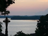
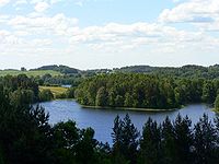 One hundred twenty-six lakes are scattered among the woods and hills. They are often interconnected by rivulets and streams and is a popular site for water tourism with kayaks. Since the park was established over 30 years ago, infrastructure for water tourism is well-developed. There are many sites to rent a boat or a kayak and also for people to rest overnight. The lakes cover 59.30 km² (or 15.5%) of the park territory. The largest of the lakes is Lake Kretuonas (8.29 km²). Lake Tauragnas
, the deepest in Lithuania (60.5 m), is also here. There are 14 lakes that are bigger than 1 km². Six lakes are between 0.5 and 1 km² and 35 lakes - 50 and 5 ha. The rest are smaller than 5 ha and some of them are slowly turning into swamps.
The Baluošas lake features seven islands, one of which has a little lake of its own. A small stream flows from this lake to Baluošas. This makes it a unique lake in Lithuania. The largest river is Žeimena (22 km in the park territory, up to 114 km in total). It is a very clean river that flows into Neris
. All lakes and rivulets belong to the Žeimena basin.
One of the most famous sights in the Park is Ladakalnis hill, from top of which six lakes can be seen. It is a geomorphological
monument.
 There are 116 villages in the park with about 2300 residents. The first villages are mentioned in the 14th century (Vilnius
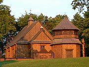
, the capital of Lithuania, was first mentioned in written sources in 1323). The most famous of the villages is Palūšė
where park administration resides. Its church, built in 1750, is considered to be the oldest surviving wooden church in Lithuania and was featured on 1 litas
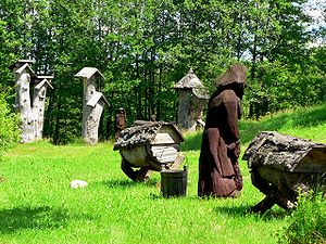
banknote. Stripeikiai
is the oldest village in the park, now known for its unique Lithuanian Museum of Ancient Beekeeping
. Ginučiai
is another famous village, and tourists are attracted by its 19th century watermill
. Being one of the few mills that still has the original mechanisms, it is declared an engineering monument. Two hill fort
s of national importance are nearby. Kaltanėnai town with 300 inhabitants is the biggest settlement.
A classical 1972 Lithuanian movie about an outlaw and national folk hero Tadas Blinda
was filmed in Šuminai village. This and five other villages are declared architectural monuments.
 Random findings show that people lived in the area about 9000-8000 years BCE. More abundant artifacts come from about 3000 BCE. It is considered that the oldest settlements were established in the area. There are 45 burial sites built in the 4th-12th centuries. The sites feature from several to 400 tumulus
es (usually a couple meters in diameter, but the biggest one is 20 meters). A tumulus is usually surrounded by a ring of stones or a shallow ditch. People were buried together with things they might need in the afterlife - jewelry, tools, guns, even horses. The park also has 11 hillforts.
National park
A national park is a reserve of natural, semi-natural, or developed land that a sovereign state declares or owns. Although individual nations designate their own national parks differently A national park is a reserve of natural, semi-natural, or developed land that a sovereign state declares or...
in northeastern Lithuania
Lithuania
Lithuania , officially the Republic of Lithuania is a country in Northern Europe, the biggest of the three Baltic states. It is situated along the southeastern shore of the Baltic Sea, whereby to the west lie Sweden and Denmark...
, about 100 km north of Vilnius
Vilnius
Vilnius is the capital of Lithuania, and its largest city, with a population of 560,190 as of 2010. It is the seat of the Vilnius city municipality and of the Vilnius district municipality. It is also the capital of Vilnius County...
. Established in 1974, it is the oldest of the five national parks in Lithuania. At first it was named Lithuanian SSR
Lithuanian SSR
The Lithuanian Soviet Socialist Republic , also known as the Lithuanian SSR, was one of the republics that made up the former Soviet Union...
National Park to emphasize that it was the first such park in the republic. In 1991, four other parks were established and were renamed after ethnographic regions of Lithuania
Regions of Lithuania
Lithuania can be divided into historical and cultural regions . The exact borders are not fully clear, as the regions are not official political or administrative units. They are delimited by culture, such as country traditions, traditional lifestyle, songs, tales, etc. To some extent regions...
. The park was renamed after Aukštaitija
Aukštaitija
Aukštaitija is the name of one of five ethnographic regions of Lithuania. The name comes from the relatively high elevation of the region, particularly the eastern parts.-Geography:...
.
Park territory occupies 405.7 km². Ignalina district municipality
Ignalina district municipality
- Structure :District structure:* 2 cities – Dūkštas and Ignalina;* 3 towns – Mielagėnai, Rimšė and Tverečius;* 726 villages.Largest population :*Ignalina – 6591*Didžiasalis – 1744*Vidiškės – 1084*Dūkštas – 1070*Kazitiškis – 383*Strigailiškis – 334...
controls about 50% of the area. Utena
Utena district municipality
-References:...
and Švenčionys district municipalities
Švencionys district municipality
-Twin towns — Sister cities:Švenčionys district municipality is twinned with the following towns: Świdnica, Poland...
control 25%. Strictly protected areas occupy 2.1%. One can enter this territory only with accompanying employee of the park. Over 70 percent of its territory is covered by woods. 80 percent of woods are pine
Pine
Pines are trees in the genus Pinus ,in the family Pinaceae. They make up the monotypic subfamily Pinoideae. There are about 115 species of pine, although different authorities accept between 105 and 125 species.-Etymology:...
stands, some reaching 200 years old.
Sixty-four species of plants, eight species of fungi, and 48 species of birds that are found in the park are included in the Red book of Lithuania. The park is famous for its biodiversity - 59% of all plant species in Lithuania can be found in the park which covers less than 1% of Lithuania's territory.
Waters
Lake Tauragnas
Tauragnas is the deepest lake in Lithuania reaching 60.5 metres of depth. The surface area is 5.13 km² and average depth 18.7 m. It is situated in Aukštaitija National Park near Tauragnai in Utena County....
, the deepest in Lithuania (60.5 m), is also here. There are 14 lakes that are bigger than 1 km². Six lakes are between 0.5 and 1 km² and 35 lakes - 50 and 5 ha. The rest are smaller than 5 ha and some of them are slowly turning into swamps.
The Baluošas lake features seven islands, one of which has a little lake of its own. A small stream flows from this lake to Baluošas. This makes it a unique lake in Lithuania. The largest river is Žeimena (22 km in the park territory, up to 114 km in total). It is a very clean river that flows into Neris
Neris
Neris is a river rising in Belarus, flowing through Vilnius and becoming a tributary of the Neman River at Kaunas...
. All lakes and rivulets belong to the Žeimena basin.
One of the most famous sights in the Park is Ladakalnis hill, from top of which six lakes can be seen. It is a geomorphological
Geomorphology
Geomorphology is the scientific study of landforms and the processes that shape them...
monument.
Villages
Vilnius
Vilnius is the capital of Lithuania, and its largest city, with a population of 560,190 as of 2010. It is the seat of the Vilnius city municipality and of the Vilnius district municipality. It is also the capital of Vilnius County...
, the capital of Lithuania, was first mentioned in written sources in 1323). The most famous of the villages is Palūšė
Paluše
Palūšė is a tourist village in the Aukštaitija National Park in eastern Lithuania. It is located south-west of Ignalina. The church of Palūšė, built in 1750, is considered to be the oldest surviving wooden church in Lithuania. The church is constructed of wood and was built without using nails,...
where park administration resides. Its church, built in 1750, is considered to be the oldest surviving wooden church in Lithuania and was featured on 1 litas
Lithuanian litas
The Lithuanian litas is the currency of Lithuania. It is divided into 100 centų...
banknote. Stripeikiai
Stripeikiai
Stripeikiai is the oldest village in Aukštaitija National Park, Ignalina district. It is best known for itsunique ethnograpic beekeeping museum. The museum was founded in 1974 by Bronius Kazlas and now receives about 10,000 visitors annually. The museum is dedicated to the development of beekeeping...
is the oldest village in the park, now known for its unique Lithuanian Museum of Ancient Beekeeping
Lithuanian Museum of Ancient Beekeeping
The Lithuanian Museum of Ancient Beekeeping , established in 1984 near Stripeikiai in northeastern Lithuania, displays the history of beekeeping in the area....
. Ginučiai
Ginuciai
Ginučiai is a village on the shore of the Lake Linkmenas in the Aukštaitija National Park, Ignalina district of Lithuania. According to the 2001 census, its population was 69. It is best known for its 19th-century watermill. It is one of the few mills in Lithuania that survive with the original...
is another famous village, and tourists are attracted by its 19th century watermill
Watermill
A watermill is a structure that uses a water wheel or turbine to drive a mechanical process such as flour, lumber or textile production, or metal shaping .- History :...
. Being one of the few mills that still has the original mechanisms, it is declared an engineering monument. Two hill fort
Hill fort
A hill fort is a type of earthworks used as a fortified refuge or defended settlement, located to exploit a rise in elevation for defensive advantage. They are typically European and of the Bronze and Iron Ages. Some were used in the post-Roman period...
s of national importance are nearby. Kaltanėnai town with 300 inhabitants is the biggest settlement.
A classical 1972 Lithuanian movie about an outlaw and national folk hero Tadas Blinda
Tadas Blinda
Tadas Blinda was a Lithuanian folk hero of the 19th century. He was a subject of several popular books, plays, and movies and is often compared to Robin Hood.-Biography:...
was filmed in Šuminai village. This and five other villages are declared architectural monuments.
Archaeology
Tumulus
A tumulus is a mound of earth and stones raised over a grave or graves. Tumuli are also known as barrows, burial mounds, Hügelgrab or kurgans, and can be found throughout much of the world. A tumulus composed largely or entirely of stones is usually referred to as a cairn...
es (usually a couple meters in diameter, but the biggest one is 20 meters). A tumulus is usually surrounded by a ring of stones or a shallow ditch. People were buried together with things they might need in the afterlife - jewelry, tools, guns, even horses. The park also has 11 hillforts.