

August Heinrich Petermann
Encyclopedia
August Heinrich Petermann (18 April 1822 – 25 September 1878) was a German
cartographer.
, Germany. When he was 14 years old he started grammar school in the nearby town of Nordhausen
. His mother wanted him to become a clergyman, but his excellence in the drawing of maps and his love for geographic readings made his choice of another career inevitable.
Heinrich Berghaus
, with support of Alexander von Humboldt
had started the ‘Geographische Kunstschule’ (Geographical School of Art) in 1839 in Potsdam
, close to Berlin, following the example of the school for engravers at the Archives Militaires Generales in Paris (since 1811). During its existence Berghaus’s academy offered only three courses, and only a few students attended:
Petermann’s father, August Rudolf Petermann, who was registrar at Bleichenrode, could not pay for the further education of his son. When he read the advertisement for Berghaus’ school he send his son’s maps and other work for evaluation. One of the maps, drawn when he was 16, shows South America, and was later published in the journal which was to carry his name. Berghaus must have recognized the quality of his work, and therewith his potential and soon took him in as a foster-son. As he had already a large family to feed, however, he requested an annual subsidy of 60 thaler
from the king to support Petermann, which request was granted. During the 3rd course Berghaus treated his nephew Hermann Berghaus the same way. Only Lange really paid for the courses, the rest following them at Berghaus’s own expense.
Petermann started in Potsdam at 7 August 1839. The education with Berghaus could be called scientifically cartographic, comprising mathematical geography (map projection
and grids
), physical geography (meterology, hydrology
and geology
) and political geography
(knowledge of borders and administrative division of European states especially). Physical training was more aimed at surveying, drafting and engraving. Berghaus’s pupils learned only the rudiments of surveying, even less than he himself had learned: their work in this area can be seen in the plan of Potsdam (Neüster Plan von der Königlichen Residenzstadt Potsdam / nach trigonometrischen Vermessungen, so wie geo- und hydrometrischen Aufnahmen ausgearbeitet in der Geographischen Kunstschule zu Potsdam unter der Leitung ihres Direktors, des Professors Dr. Heinrich Berghaus. 1845). They were not topographers and only used topography as published in the large-scale maps of that era as a general basis for their later, more generalized works. They were taught more to draft and engrave middle-scale geographic maps of states, continents etc., or their parts (e.g. the map of upper- and middle-Italy in 1847 for Stielers Handatlas
, which was based on Attilio Zuccagni-Orlandini's 1844 topographic map in nearly 100 sheets), small-scale generalized school maps, and especially applied geography and cartography as shown in their collaboration on the Physikalischer Atlas and the maritime atlas. During their study lithography
, though not cutting as fine a portrayal as copper engraving, was on the rise because it was much cheaper. Though some experiments were made by Berghaus, e.g. for geological maps, by mixing copper engraving for the line- and other features and lithography for coloured polygon
s, there was no technology which could replace the exquisite expression copper engravings could reach. So the students mainly learned this art. Only at the end of his live Petermann became more enthusiastic for lithography, which had advanced by then. Up to and including the 10th edition of the Stieler Handatlas (1920–1925) the Perthes institute, where he worked from 1854 onwards, used copperplate engravings as the basis for its maps. All some 460 copperplates of this edition are currently preserved in the Perthes collections in Gotha!
Berghaus had been riding numerous hobbyhorses (terrain representation, isolines, scale
indicators, map projection
s, etc.) without much success, but now he could finally put them to work with his pupils. He very successfully disseminated many of his ideas and concepts. Moreover, his students somehow learned better than he to limit their endeavors in order to bring more of them to full fruition. Though the school itself had but few students, its residency in Potsdam, connected by rail to Berlin, and the fame of Berghaus attracted many geographers (e.g. Alexander von Humboldt
, Carl Ritter
and Zeune), cartographers and explorers. Petermann spoke highly of his encounters with von Humboldt and has drawn several maps for his Atlas von Asien, on which the rendering of the Asiatic mountain-chains was of a quality corresponding to the then current view of the geographic sciences.
Because of all these contacts the students were confronted with many opinions and views on the state of science and the world that would not normally have been part of their curriculum. Besides, we may take Poggendorff seriously when he sees Petermann as ‘private secretary and librarian of H.K.W. Berghaus’ in the years 1839–45, so we can assume that Petermann was at least quite up to date on many affairs to do with geography and cartography, for Berghaus had large collections of maps, books and notes to draw on.
During and after their training, students were obliged to take part in most of the school’s enterprises. In the years 1839–1848 the school produced maps for Stieler’s school atlas, and Berghaus’s Physikalischer Atlas, school atlases, the Atlas von Asien, the Prussian atlas, and the maritime atlas.
In 1842 Alexander Keith Johnston (1804–1871) visited Gotha
to discuss several projects with Perthes. These negotiation first resulted in the publication of the National Atlas of General Geography, which contained 4 maps by Berghaus. Though Berghaus deemed the commercial and scientific climate in England not ready for scientific maps Johnston persisted in wanting to publish a translation of the Physikalischer Atlas, on which he requested aid from Berghaus. With a letter of recommendation by von Humboldt in October 1844 Heinrich ‘Henry’ Lange
joined Johnston in Edinburgh for this purpose. Petermann stayed behind in Gotha and became teacher in the 2nd course of Berghaus’ school. In April 1845 he followed Lange, who received him in his house in Edinburgh and acquainted him with the friends he had made. Together they made a tour through the Grampians, applying what they had learned by using barometer
s for height measurements and taking geological and botanical samples. Meanwhile they also worked on the Johnston’s Physical atlas (Physical geography, illustrating in a series of original designs, the elementary facts of geology, hydrology, meteorology and natural history etc.) and several other cartographic publications.
During his time in Edinburgh he may have come into contact with the publisher G.H. Swanston, for whom he constructed several maps for The Royal Illustrated Atlas, Of Modern Geography, 1st edition published in 27 parts 1854–62. and republished probably in 1872. He also may have met in Edinburgh with John Bartholomew Jr.
(1831–1893), who created many maps in the same atlas. John Bartholomew became Petermann’s student in Gotha from 1855 till he was recalled to his father’s firm in 1856. The German school of cartography was pre-eminent, and four generations of Bartholomews widened their knowledge by studying with the German masters. John George’s son Ian
studied in Leipzig (1907–8) with Oswald Winkel. His grandson John Christopher
carried on the tradition, studying with Eduard Imhof, the great Swiss cartographer, in Berne and Zurich in 1960, and his son John Eric followed in 1977 with Imhof’s pupil, Ernst Spiess.
"Bartholomew is best known for the development of colour contouring (or hypsometric tints), the system of representing altitudes on a graduated colour scale, with areas of high altitude in shades of brown and areas of low altitude in shades of green. He first showcased his colour contouring system at the Paris Exhibition of 1878; although it initially met with skepticism, it went on to become standard cartographical practice". However, he might have picked up this idea during his time in Gotha as the colour scheme was first introduced by Emil von Sydow
(1812–1873) in 1838 when he developed a color methodology for landscape features using hachures, where green was depicted for lowlands and brown used for highlands. The white for the higher reaches might later have been used by Hermann Haack (1872–1966) for his Perthes’ wall maps.
Several maps have been co-constructions of Petermann and Bartholomew.
(1834–1913) was apprenticed to him, before he went in 1855 into the service of the Topographical Department of the British War Office. Petermann's firm published, among other things, the Atlas of physical geography with descriptive letter press (1850, with Thomas Milner), and the Physical statistical maps of the British Isles, showing the geographical distribution of the population and inland hydrography. His productions for the Journal of the Royal Geographical Society included the map Survey of the Sea of Aral by commander A. Butakoff, 1848 & 1849. He also established life-long relationships with many scientists, politicians and explorers, mainly through his membership of the Royal Geographical Society
(RGS) of London. In 1847 he became member of the RGS. When he was 28 in 1850 he was elected under-Secretary. In 1868 he was awarded with the prestigious ‘Founders medal’ of the RGS. Queen Victoria
, at the suggestion of Robert Bunsen
, appointed him 'physical geographer-royal'.
Early in his career Petermann already wanted to further the cause of geographical exploration as shown by his concern for and interference with James Richardson's
expedition. The purpose of this expedition, which was supported by the British government, was to negotiated trade treaties with the rulers of the middle Sudan. Petermann, supported by Carl Ritter
and Robert Bunsen, pleaded with the British government to let Heinrich Barth
and Adolf Overweg
join up with Richardson’s expedition to assure that geographical and scientific aspects which they might encounter were taken care of. When still affiliated with the Zeitschrift für Allgemeine Erdkunde he published their progress in this journal, and when he started Petermanns geographische Mitteilungen he followed this through.
It is no surprise to see that his sphere of interest in ‘current’ geography, was only sharpened when paired with his updating of Stieler’s Hand-Atlas. In stressing the geographic nature of cartography, he showed himself more a Humboldtian than a follower of Ritter’s political-historical school.
M. Linke et al. wrote in 1986: “There seems to be no doubt that Petermann’s work contributed to the high standards of British cartography during these years. T.W. Freeman has noted that ‘Fine maps had been produced in the 1851 Census by August Heinrich Petermann during his long stay in Britain (1845–54) with the Johnston map firm in Edinburgh and later in London, but since his departure the standard has declined’ ”.
In 1852 and 1853 Petermann published some maps on cholera in Britain, explaining that the map, better than tables, can show the progress and victim density of the disease, following the example set by Heinrich Berghaus in his Physikalischer Atlas, Band II, Abt. VIII, no. 2 (1847). These were later followed by Keith Johnston in the second edition of The physical atlas of natural phenomena (1856) .
also started to work with Perthes. When he was refused a position equal to Petermann he left Perthes and started to work for Brockhaus in Leipzig.
When Petermann went to the Gotha Institute part of the original plan was that he would revive the Geographisches Jahrbuch (Geographical Yearbook), which Heinrich Berghaus had edited from 1850 to 1852. At the suggestion of the manager Adolf Müller (1820–1880) it was decided instead to publish the monthly Mittheilungen aus Justus Perthes Geographischer Anstalt über wichtige neue Erforschungen auf dem Gesamtgebiet der Geographie von Dr. A. Petermann (PGM) (Communications from the Justus Perthes Geographical Institute concerning important new studies in the whole field of geography, by Dr. A. Petermann). These were to be published in ‘casual issues’. Their relation to several of the Perthes atlases was plainly expounded in the preface to the first issue of 1855:
“Our ‘Communications’ will differ from all similar publications in that they will summarise and graphically illustrate the results of new geographic explorations in precisely executed and carefully detailed maps. Every issue of our periodical will therefore include one or more map supplements, and their design will guarantee a continuous and easily accessible supplement in easy-to-manage form with special regard for those who own Stielers Hand-Atlas, Berghaus’s Physical Atlas, and other map publications of the (Perthes
) Institute. We will take special care to always present our readers with important new discoveries immediately or as fast as possible.”
In the same preface he put the main focus of the ‘Mittheilungen’ on physical and bio-geography, geology and other natural phenomena, and to a lesser degree on ethnography. Its greatest strength lay in the accompanying maps, for it was thought these would show best the results of geographic exploration. In an age hungry for adventure, but not yet totally scientifically literate, this was the best way to attract the largest possible group of interested readers. The maps not only supplemented several of the Perthes atlases, but were also used as a forum to elaborate on new themes, thus widening the thematic scope of cartography. He expresses his emphasis on maps anew when he writes in the Geographisches Jahrbuch:
"In first instance the end result and final goal of all geographic investigations, explorations, and surveys is the depiction of the earth’s surface: the map. The map is the basis for geography. The map shows us what we know about our earth in the best, clearest and most exact way. The contemporary map should so depict the earth’s surface that one can not only measure the horizontal positions of and distances between all points and localities, but also clearly distinguish vertical variations, from sea level to the highest summits."
Petermann was responsible for drawing most of the maps in the first few years of the journal. His strength was in the analysis and evaluation of all sources available. As such one can say that the indication ‘Originalkarte’ (original map) in many titles was well earned, for few slavishly copied what explorers or other experts had sketched. German geographers, like Hermann Wagner (1840–1929), claimed that in other geographical journals explorer's maps were just copied instead of having them evaluated by cartographers first. Maps based on recent exploration reports were always, when possible, complemented with route maps from previous expeditions. He did not like to infer or extrapolate from the sources, for that might give inaccurate measurements, so many of his maps show large blank spaces. How right he was in this respect was demonstrated in 1911 when Julien Thoulet drafted bathymetric maps for the territory of France. In these four maps he draws hypothetical isobaths, which are based on respectively 15, 31, 154, and 308 altitude measurements per 153821 square miles (398,394.6 km²) for France and the adjacent territories. (A reasonable amount of measuring points for precipitation and temperature maps would be 1,500 and 600 per 100,000 km² respectively to create acceptable isoline maps for these phenomena). These give schematic negative relief maps, which hardly even approximate the true relief of the territory. Thoulet wanted to show that the few bathymetric measurements available for the vast oceans would only vaguely approximate the true relief of the ocean floors. Petermann must have had the same idea intuitively for his exploratory maps. He was keen, however, to introduce spot heights and spot depths in the maps he drafted in order that others could benefit from them.
In 1870 Petermann advocated the use of a red and blue color scheme for temperature maps of the oceans.
Although the number of projection methods increased at a reasonable rate, a few well-known sorts, like the stereographic
and orthographic equatorial
projections and the projections of Lambert
, Flamsteed and Mercator
, remained the most popular. Petermann did publish reports on the new projection methods of J. Babinet
(1854) and J. James (1857), and G. Jäger, but he hardly used them. Though Petermann and Ernst Behm (1830–1884; like many of the famous Gothaer geographers and cartographers Behm had first another profession. He was a physician, who learned the geographic trade in practice) wrote many articles about geodesy
and surveying
, they rarely got involved in other technical and theoretical cartographic issues.
Petermann concerned himself much more with printing technology, especially colour-lithography. Although they produced many color maps in this way in the 1870s, more and more maps returned to hand coloring, for it then became cheaper than lithography. According to Stams, the Gotha Institute may have produced some 2,500,000 hand-colored maps for all its cartographic products in a decade, or 800 per day! In his last article published before his death, Petermann speaks enthusiastically about the newly developed photogravure
, which considerably reduced costs per map while also increasing production speed. In his opinion the 715-sheet Austrian map was probably twenty times more efficiently produced than an engraved version would have been, for its production took only a fifth of the time and a fourth of the costs.
In 1857 the President of the Royal Geographical Society, Sir Roderick Murchison
, praised PGM for its fast reporting of diverse explorations, and spoke against the jealousy of those in his own Society who felt that exploration supported primarily by the British should first be published in Britain: he thought the Perthes Institute enriched the scientific geographic discourse.
, Stülpnagel, Heinrich Berghaus
, Emil von Sydow
, etc., as well as new cartographers like Carl Vogel and Hermann Berghaus. According to Hermann Wagner it was not felt wise to have any of these employees appointed as head of the establishment. Instead the firm was led by Adolf Müller, not a cartographer, but an economic manager.
The cartographers Petermann trained included Bruno Hassenstein
(1839–1902), Hermann Habenicht (1844–1917, who from 1897 onwards trained Hermann Haack, the 20th-century editor of PGM), Ernst Debes (1840–1923. He could have come to rival Carl Vogel, but in 1868 he left the Gotha Institute to co-found his own firm, [Heinrich] Wagner & Debes, which published one of the six famous families of German reference atlases E. Debes neuer Handatlas, later called Grosser Columbus Weltatlas), Carl Barich, Arnim Welcker (1840–1859), Ludwig Friederichsen (who worked on the Stieler and PGM from 1859 to 1863, and later founded the geographical society of Hamburg and became very active in German colonial politics.) in the 1850s, and Fritz Hanemann (1847–1877), Christian Peip (1843–1922), Bruno Domann and Otto Koffmahn (1851–1916) in the 1860s. They soon learned to produce maps as good as their teacher’s, and eventually even better. But they had probably listened well when Petermann pointed out the need for an improvement in map lettering, in elevation figures (though elevation and bathymetric figures were common in topographic maps and charts, Petermann was the first to include them in geographic maps), more accurate engraving and better coloring, for under his directions the maps of the Stieler became more uniform in expression. In this they were also guided by the more than consistent work of Vogel, and Von Sydow’s critical remarks concerning the advantages and disadvantages of certain styles in his Kartographischen Standpunkt Europas.
Petermann was also keen to use physical characteristics as background for thematic maps, an idea followed by his pupils. When Herbert Louis demanded in 1960 that the terrain underlying thematic maps should indicate elevations, hydrological networks, settlements and traffic roads, he cited Petermann as the first cartographer who used a terrain map as basis for population maps. By using hachuring as a basis for his Karte des Österreichischen Kaiserstaates zur Übersicht der Dichtigkeit der Bevölkerung nach dem Census von 1857 (Map of the Austrian imperial state as an overview of the population density after the 1857 census, 1860) and the map Die Ausdehnung der Slaven in der Türkei und den angrenzenden Gebieten (Expansion of the Slavic populations in Turkey and adjacent territories, 1869) Petermann continued the representation of geological, climatological and ethnographical data that his teacher Heinrich Berghaus had begun two decades before.
Other sections of the journal were: Geographische Nekrologie des Jahres **** (1858–1884), Geographie und Erforschung Polar-Regionen (nr. 51/1871-nr. 135/1878), Monatsbericht über Entdeckungsgeschichte und Kolonisation (1885), Kleinere Mitteilungen (1889–1939), Geographischer Anzeiger (1899–1902), Kartographischer Monatsbericht aus Justus Perthes' Geographischer Anstalt in Gotha (1908–1911), Militärkartographie (1909–1914), Staaten und Völker (1923), Neue Forschung im Felde (1935–1939), (Wehr- und) Militärgeographie (1935–1936), Kartographie (1941–1945).
voyage to the Lena
, and the maps of the United States and Australia, suggest this may not be true. Perhaps he no longer designed, constructed and drafted the maps, as he had with the Barth maps, but he most likely continued to play a role in the conception and design of the maps, especially those in his fields of interest.
Petermann was very well aware that even topographic maps were not yet a true representation of reality (this is illustrated by the depiction of the Liparian Isles, which were not securely situated until Darondeau’s French survey in 1858), let alone medium- and small-scale maps of the interior of continents and the polar regions. One could still hardly speak of dense topographic, orographic and hydrological information. Though the maps in the Stieler looked dense with information they were mainly filled out with information where space in the image allowed, and the cartographers had little choice what to depict by the lack of known phenomena. The density of information did not indicate how thoroughly an area had been explored, for the cartographers selected their data and drafted the maps in such a way as to give a balanced image as possible. As Petermann put it in 1866:
“In fact, our cartographic knowledge of the territories of the earth is far less than is generally supposed. … [In the maps,] even the African and Australian terrae incognitae shrink more and more, and there remain [only] a few blank spots, maybe 'wild territories', where there is 'nothing'. In reality everything we see on our maps is just the first step, the beginning of a more accurate knowledge of the earth’s surface.”
Only in the detailed maps in PGM, where lots of spaces were left blank, could one really judge how haphazard and incomplete the geographic knowledge was. J.G. Bartholomew in 1902 phrased Petermann's drive as: "The filling up of the blank spaces of the unknown in his maps had such a fascination for him that rest seemed impossible to him while any country remained unexplored".
The results of the exploratory expeditions cried out for presentation in map form, and PGM published exploration results as quickly and accurately as possible. Petermann had all results he received from explorers checked against the considerable information and maps available in the Perthes Institute. This fund of knowledge grew to be so large that the Institute soon had a large library of manuscripts, books, atlases, and maps at its disposal that could vie with any university or society collection. In the 1980s it was thought that the Perthes-archives contained 180,000 printed maps and around 2,800 atlases. In the 1990s the estimate was 1,000 m of archive, some 400,000 maps (including manuscripts), and some 120,000 geographical works. All collections (currently estimated at 185,000 sheets of maps, 120,000 geographical works, and 800 m of archives) were acquired in 2003 by the Free State of Thüringen and deposited with the library of the University of Erfurht in its research center in Gotha.
But the maps went beyond a simple presentation of the itinerary by also describing the area explored with all knowledge available and pointing out gaps that remained to be filled in the current knowledge. So the impact was reciprocal. Moreover Petermann gave directions to explorers in exchange for which he was allowed to publish their results as soon as possible.
, who wished to take part in the Richardson expedition. He later also persuaded the English government to send Eduard Vogel
after them for scientific research and astronomical observations. Petermann published the results under the title Account of the expedition to Central-Africa. When first Barth and later Vogel failed to return at the expected time Germany franticly tried to discover their fate, much as Britain had with Franklin in the Arctic area. This led to many new German expeditions to Africa (by Theodor von Heuglin
, Hermann Steudner
, Theodor Kinzelbach, Karl Moritz von Beurmann, Gerhard Rohlfs, Karl Mauch and others), most financed by gifts due largely to Petermann’s agitating actions and publications. Many found their death in Africa as shown in the map with the subtitle Four martyrs of German science in Inner-Africa shows, i.c. Overweg, Vogel, Beurmann and Steudner.
Petermann first drafted maps of Barth & Overweg’s routes for the journal of the German Geographical Society and followed these up with maps in PGM in 1855, 1857, and 1859. These were later worked into the maps for Barth’s voluminous work on his African voyage of 1850–55. The route maps were used in new maps up to 1893.
When we compare the maps in Barth’s work and in PGM we may get an idea how the information was turned into images. The first map in Barth’s work gives an overview of his routes. The routes of Livingstone
have already been engraved, but have not been highlighted by coloring. The 1857 issue of PGM uses the same copperplate, but with both routes highlighted and another title. Sheets 2–14 of Barth’s work are route maps on the scale 1:800,000 and 1:1,000,000. In 1855 PGM gives only a summary of the routes of the first half of the total tour, on scale of 1:2,100,000, with added profiles along the borders that do not appear on the detail maps. This was a corrected issue of a map first published in London. In the 1857 issue the map of Touareg-country is a copy, but mainly uncolored. Maps 15 and 16 of Barth’s work form a beautifully drafted and colored two-sheet map at a scale of 1:6,000,000 and measures 57 x 85 cm. It depicts the approximate territories of the indigenous tribes. The other maps in the 1857 issue show rather small details of the routes, not beautifully executed, while in the text a plan of Agades is inserted (I do not know if it exists in Barth’s work). All in all there is little overlap, also because the scales used for the different works are mostly different. But the smaller maps are clearly generalizations of the maps in Barth’s work. The images in Barth’s look sharper, but of course that is also because they are engraved on a larger scale, while all the areas outside the routes, of which nothing or not enough is known are blank.
These routes, like many others, were reused in many new maps, such as Barth’s route, supplemented with the 1828 routes of René-Auguste Caillé (1799–1838) and Léopold Planet (1850).
"The basic idea of our map was to give travellers a sure support for the choice of their routes and guarantee the direction of the explorations, to resolve doubts and stimulate the elucidation of the unknown, and to offer a means for friends at home to follow their moves and to judge the value of their labour. This by creating a cartographic representation of the least known central regions of Africa utilizing all material at hand as completely as possible, to display the range of our contemporary knowledge as well as the way this knowledge is acquired and the degree of its reliability."
[ (1820–1894)] during the session of the Royal Geographical Society of London on 22nd November 1852, would be persuaded to know that the natural beauty of the Arctic regions cannot be surpassed by any other in the world." Though the accompanying map shows his theory concerning an extended Greenland he doesn't write about this, but mainly about his errouneous theory concerning the behavior of the Gulf Stream. Supplement IV gives an overview of the knowledge of the area around Spitsbergen and the central Arctic. It contains articles by Petermann, R. Werner, N. Dunér and A.E. Nordenskiöld, Dr. Malmgrén, Barto von Löwenigh, and G. Jäger, and is accompanied by three maps. Petermann published this supplement issue to encourage people and institutes to support German efforts to explore the central Arctic. The first map, scale 1:40,000,000 covers both the Arctic and Antarctica, with the routes of the explorers from Cook to 1861. He measures the unexplored area in the Arctic as 140,000 German square miles (approximately 7,700,000 km²), comparing it to Australia’s total of 138,000. The unexplored Antarctic he calculates as 396,000 German square miles (approximately 21,800,000 km²). Petermann uses the map specifically to show the benefits of using ships for exploration, rather than the sledges usually used by the Americans and the British. He must have been convinced that the central Arctic contained vast expanses of open water and land, the latter presumably extensions of Greenland and Spitsbergen. Though the routes in the Antarctic map have been engraved, they are not highlighted in color. Instead Petermann has colored the polygons that encompass the areas covered by the several explorers. This highlights the unexplored area clearly, even though it is blank. But Petermann is definitely more interested in having the Germans explore the Arctic than the Antarctic, presumably because the costs of an Arctic expedition can be met more easily than those of an Antarctic one. The more detailed map of Spitsbergen not only shows the Swedish surveys of 1861 to 1864, but also the presence of coal fields, coastal areas with driftwood, and areas where reindeer can normally be found. Petermann’s last map is in the modified polar projection first proposed by G. Jäger of Vienna. Jäger had developed this projection specifically to facilitate the palaeontological analysis of the inventory of animal life in the Arctic area. Petermann thought this the best projection for planning the laying of telegraph lines.
and the consequent expansion of the Prussian realm. In PGM that same year he again turned to the FDH for support. In 1868 Petermann roused so much support for his idea in the German public that his Arctic expedition actually took place.
He proposed to follow a course East of Greenland
, for he and other geographers were convinced that Greenland stretched much farther North than was known in that time. Though Ferdinand von Wrangel started a four year long expedition in 1820 to find possible land North of cape Shelagskiy and couldn’t find any land he noted a Chucki chief saying: “One might in a clear summer’s day descry snow-covered mountains at a great distance to the North.” Heinrich Berghaus, Petermann’s teacher, included this information in the right hand corner on his isotherm map of 1838 for his Physikalische Atlas with the text ‘possible polar land’ [Wahrscheinliches Polar-Land]. So it might be possible that Petermann based his views on this information.
He published the same map of the Arctic and Antarctic as in 1865, but now with Greenland stretching over the Arctic and ending in Wrangel Island
close to the Bering Strait
. It shows the possible route of the German expedition. The Antarctic map now uses only two colors to delimit the areas covered by James Cook
and others. Later in that volume he published two maps of the route sailed by the German expedition. Unfortunately they discovered a finger of permanent pack ice stretching from the north to approximately 76°, which made progress further North impossible. Since we of course know this only by hindsight we can understand that Petermann was not daunted in his endeavors to reach the North Pole and demonstrate a possible passage to the Pacific Ocean, even when this expedition had partly failed. In 1869 he published a map of the Arctic Ocean North of Wrangel Island with all exploration routes between 1648 and 1867 and a map with sea-temperatures in the Greenland Sea and the Norwegian Sea as observed by the German expedition. And again two maps of the German expedition in Ergänzungsheft 28.
In 1874 he again published an overview map of the Arctic scale 1:16,000,000 now with all the routes from 1616 to the end of 1874, complemented with the new meteorological weather stations. Strangely enough the route of the 1868 German expedition is not engraved in the image. Petermann still believed, however, that Greenland stretched far into the Polar region. The text in the map reads: ‘Unerforscht, wahrscheinlich Land oder Inseln (Petermann’s Hypothese)’ [unexplored, probably land or islands (Petermann’s hypothesis)].
In the case of the polar regions Petermann’s point of view deviated from most contemporary views. While many, especially the Americans and British, saw a possible passage in the Northwest, where they expected to find a passage after rounding Greenland, Petermann thought this not a viable option. But this did not prevent him from publishing many reports and maps of the American and British explorations in this area, sometimes translated from the journal of the Royal Geographical Society and other geographical societies. Though he was right in hypothesizing that the warm Gulf Stream complemented the cold Labrador Stream and that the warm stream extended far north of Spitsbergen and Nova Zembla his thesis that it warmed the Arctic proved erroneous. Though he thought it to be a deep stream he still could not have imagined how deep it really was. On the other hand he was wrong about the extension of Greenland. He wrote:
“… but such an enormous glacier like the one named after Von Humboldt points at extensive eternal snow and glacier regions and this speaks for an extension of Greenland to the North …”
His view may have been reinforced by some explorers who sighted land at higher latitudes than the tip of Greenland.
While Petermann was honored in 1876 by the American Geographical Society, during the last week of a 3 weeks visiting the U.S.A., Dr. Isaac I. Hayes disputed the hypothesis of Petermann’s land tongue stretching from Greenland to the Bering Sea, though he agreed that the Arctic Ocean would possibly be open water. In the Soviet Encyclopaedia the following is written concerning Petermann’s hypothesis:
“He put forward the hypothesis of a warm Arctic sea and the existence of land in the central Arctic, dividing the sea in two. In 1874 Payer ‘viewed’ land north of Franz-Joseph-Land and put it on the map under the designation ‘Petermann Land’. But during the ice drift of the Russian ship ‘Saint Anna’ (1912–1914) and the marches of the navigating officer W.A. Albanow it was established that it did not exist.”
The seemingly impossibility of the Northwest Passage was acknowledged long after his death. Only in 1904 did Roald Amundsen
achieve the passage. When it came to the Northeast Passage his view that a passage was possible between Nova Zembla
and Spitsbergen
proved right after Nordenskiöld’s trip to the Ob
and Yenisei river
, and this while encountering stiff opposition and bearing the weight of some failed German expeditions. The ultimate proof by Nordenskiöld’s trip with the steamship ‘Vega’ sailing around the Taimyr peninsula was published in 1879 in PGM shortly after his death. Since the map was drafted on top of Petermann’s earlier map of Siberia, from 1873, I conclude that this might have been a way to honour Petermann. The route of the ‘Vega’ appeared on a Russian copy of Petermann’s 1873 map, which was reason enough for the editors to add it in their 1879 map. The map shows clearly to what degree the descriptive data of older explorations (i.e. Vasili Pronchishchev
['Prontschischtschew'], 1735–36; Hariton Laptev ['Laptew'], 1739–43; Semyon Čeluskin ['Tscheljuskin'], 1735–43; Fyodor Minin
and Dmitriy Sterlegov ['Sterlegow'], 1740; and Alexander Theodor von Middendorff, 1843) could be trusted when drafting a map from many sources and trying to amalgamate them into a single image. The difference between the coastlines on the two maps sometimes can be as much as ½° latitude and 1° longitude. Looking at Cape Taimyr, the channel between it and the mainland is reduced from approximately 10 km to a few kilometres by the Swedish exploration! The only exception was the information derived from P.F. Anjou (1823), which was based on astronomical observations, and is the same in both maps. The article (translations from Swedish and Danish with a preamble by Behm) and map appeared four months after the ‘Vega’ had arrived in Irkutsk
. Hassenstein drafted the new map, maybe using the older draft. The title was hammered out of the old copperplate and replaced by a new one, while Nordenskiöld’s data were engraved, and printed in red, making it look like an overlay on the old map. Because of the use of lighter background colors the newer map looks much fresher than the older one, though only six years lay between the two.
We unfortunately do not find his famous six-sheet map of the United States (Neue Karte der Vereinigten Staaten vor Nord-Amerika in 6 Blättern) in the issues of PGM. It was produced for the sixth edition of the Stieler on scale 1:3,700.000, though a small part appeared in the next annual as an illustration of the exploration of Northwest Texas.
), he tends to disagree with Jakob Erhardt, one of the missionaries of the Church Mission Society
of London, concerning its situation and extension. Erhardt was erroneous in that he situated the lower tip of the lake around 13° South 36° East and made it bend westward to 28° East, with a probable extension to 24° East. Furthermore he though that Lake Victoria
, Lake Tanganyika
and Lake Nyassa were one inland sea extending to 6° North. A lack of data led Petermann to agree with his erroneous shape of the lake or lakes, but he was not convinced of its wide extension to the west and north. As for the sources of the Nile he was not so much mistaken, as they were indicated by a text near the equator between 30° and 36° East, but this was not so hard to induce. When one views the ethnographic and trade information in the map and interprets them from a relative topological point of view we can see this as the strength of the missionaries’ reports. As their mission was focused on people and not on the natural environment this kind of information was of great importance to them. But geometrically their information could not be trusted, in part because most of their information was based on verbal reports of the native tribes.
At other times he depicted maps of the same area from several authors together in one supplement map to show the authors’ different interpretations. This was the case with, for example, the map of the Kerguelen and McDonald Islands sighted by John Heard (1853), William MacDonald (1854), Hutton (1854), Attway (1854), Rees (1854), and Neumayer (1857), with several comparisons of explorations since James Cook
. The same with small maps (scale ca. 1:33,000,000) of the central part of southern Africa, which shows different interpretations by Heinrich Kiepert
(1855), J. McQueen (1857) and David Livingstone
(1857). Or with the representation of the Gabon countries, which show interpretations by August Petermann, Thomas E. Bowdich, William D. Cooley, Heinrich Kiepert, Paul Belloni du Chaillu and Heinrich Barth
.
Many times he included an outline map of Germany, or parts thereof or other countries to show the vastness through which the explorers had to travel. This must have contributed to the understanding and compassion the readers felt for the sacrifice and hardships the explorers had to go through to come to the results presented in the articles and maps.
. When Stülpnagel died in 1865 Petermann became responsible for the Stieler. He drafted some maps (e.g. Russland und Skandinavien, Süd-Polar Karte, Neu-Seeland, Australien, Süd-Ost Australien ) for the 4th edition (1863–1867), which reached 83 maps. In the 5th edition (1868–1874) we can see the hand of the master clearer, as the maps become more uniform and the style of the 'Gotha School' becomes more distinct.
and geology
— old disciplines by then with their own technical language already — meteorology
, botany
and biology
. Articles on anthropogeography usually reach no further than ethnographic descriptions of regions. It is still the era of data-gathering and in this they weren’t far beyond the cameralistic nature of the first half of the nineteenth century. One should have expected more articles concerning (parts of) Europe, but a count in the annuals for 1860–1864 shows that only 16% of the articles and 22% of the Kleinere Mitteilungen (small communications) concerned Europe. As accommodation one might say that the journal, though geographic by nature, was aimed at popular use. That was one of its strengths, as shown by its large circulation.
“Petermann’s achievement falls in a period in which raw material was gathered, especially through explorations. It was the flowering of geographic dilettantism. Interest was not only stirred by news as such, but the news in itself was interesting, because every educated person without special prior knowledge could understand it.”
According to Weller Petermann signed 226 articles in Petermanns Geographische Mitteilungen, including 41 on Africa, 98 on the Polar regions and 37 on the history and use of cartography. The same source puts his total production of maps at 535, including his maps for the Stieler, the Physical atlas and several miscellaneous items. Stams, using the ten-year indexes, counts 280 maps in Petermanns Geographische Mitteilungen that can be said to have been constructed and edited by him.
published The descent of man
it was the beginning of the expansion of human geography, which till then was only rarely focused upon, except in the field of ethnography. The physical-deterministic view of humanity that followed led to the rise of the branch of geography we now call anthropogeography, especially after 1875, when Friedrich Ratzel (1844–1904) was the first new professor of geography appointed in München and later Leipzig (only Carl Ritter ever before had been professor of geography worldwide).
In 1856 Petermann had married Clara Leslie and had two daughters with her. They were divorced in 1875. A year later he married for the second time. As time wore on he seemed to have suffered more and more from family problems. It is also supposed that for many years he suffered from manic-depressive moods and he seemed to have always kept a revolver in close proximity.
All these changes and troubles may have contributed to the fact that Petermann died by his own hand
at Gotha on the 25th of September 1878. The fact that Gotha was becoming less exclusively the center of exploration — which so enchanted the large masses — and became more scientifically focused might also have played a role.
In 1902 J.G. Bartholomew wrote: "It is only a fair tribute to Augustus Petermann to say that no one has done more than he to advance modern cartography, and no man has ever left a more fitting monument to himself than his Mitteilungen, which still bears his name, and under the editorship of Dr. Supan, is the leading geographical authority in all countries. But to the absorbing facsination of his work Petermann sacrificed all other interests in life and died a martyr to geography". That fame perished quickly was shown by Hermann Wagner
in his article of 1912, when he commemorates the merits of the Gotha epoch under Petermann and finds that nobody up till then had written about the making of the history of geography and cartography and that all those pioneers were all but forgotten, even though the journal carried Petermann’s name since 1879.
In 1909 a monument with Petermann’s effigy from the workshop of Max Hoene-München of Gotha was erected in the Ducal gardens of Gotha, a stone’s throw away from the institute where he had worked for so many years. The monument was offered by the German geographical societies. Petermann in his time was well paid by Perthes as is shown by his beautiful villa close to Gotha’s railway station. A fine way to meet his guests, friends, scientists, explorers, etc.
, Petermann Bjerg (= Fjeld, Peak, Bjaerg, Bjoerg), Petermann Glacier, Petermann Peninsula (= Halvø), Petermannbreen
(= -Glacier), Petermannfjellet (= Cape). According to Hugo Wichmann, Capt. Bullock was probably the first to name a physical feature after Petermann, on a printed English chart of 1860. In the same report he counts thirteen features in Asia, Australia and New Zealand, and the Arctic and Antarctic regions, named between 1860 and 1874. Some of them were renamed by other explorers and one turned out not to exist, Petermannland, an island North of Zemlya Frantsa-Iosifa (Franz Josef Land) sighted by Capt. Fligely and named by Julius Payer, which later proved nonexistent. We may keep this name in mind, however, as a proof of Petermann’s vision and drive to have the region explored, though this sometimes revealed different physical objects than he had hypothesized. In a later age, even a crater on the moon was given the name Petermann crater
, situated halfway between Mare Humboldtianum and Peary in the northern polar region.
Petermann thought that the naming of newly discovered physical features was one of the privileges of a map-editor, especially as he was fed up with forever encountering toponyms like 'Victoria', 'Wellington', 'Smith', 'Jones', etc. He writes: "While constructing the new map to specify the detailed topographical portrayal and after consulting with and authorization of messr. [Theodor] v[on] Heuglin
and count [Karl Graf von Waldburg
Verlag, the publisher of PGM, was taken over by Ernst Klett Schulbuchverlag in Stuttgart. In 2003 the Perthes archives (180,000 maps, 120,000 geographic publications, and 800 m of business archives) were bought by the Free State of Thüringen and deposited in the Gotha annex of Erfurt University. In 2004, after 149 years of publication, the journal Petermann’s geographische Mitteilungen ceased to be published. The municipality of Gotha bought in 2010 the business premises and the accompanying grounds on Justus-Perthes-Straße 1–9 and Gotthardstraße 6, but has not decided yet what to use them for. Thanks to this initiative many of the letters Petermann sent or received have been saved for future study, as also are the drafts he made for many maps.
More private data concerning August Petermann may be found in :
Germany
Germany , officially the Federal Republic of Germany , is a federal parliamentary republic in Europe. The country consists of 16 states while the capital and largest city is Berlin. Germany covers an area of 357,021 km2 and has a largely temperate seasonal climate...
cartographer.
Early years
Petermann was born in BleicherodeBleicherode
Bleicherode is a town in the district of Nordhausen, in Thuringia, Germany. It is situated on the river Wipper, 17 km southwest of Nordhausen. On 1 December 2007, the former municipality Obergebra was incorporated by Bleicherode. Every Thursday, there is a market held in the town.One of...
, Germany. When he was 14 years old he started grammar school in the nearby town of Nordhausen
Nordhausen
Nordhausen is a town at the southern edge of the Harz Mountains, in the state of Thuringia, Germany. It is the capital of the district of Nordhausen...
. His mother wanted him to become a clergyman, but his excellence in the drawing of maps and his love for geographic readings made his choice of another career inevitable.
Heinrich Berghaus
Heinrich Berghaus
Heinrich Berghaus was a German geographer.-Life:Berghaus was born at Kleve. He was trained as a surveyor, and after volunteering for active service under General Tauentzien in 1813, joined the staff of the Prussian trigonometrical survey in 1816...
, with support of Alexander von Humboldt
Alexander von Humboldt
Friedrich Wilhelm Heinrich Alexander Freiherr von Humboldt was a German naturalist and explorer, and the younger brother of the Prussian minister, philosopher and linguist Wilhelm von Humboldt...
had started the ‘Geographische Kunstschule’ (Geographical School of Art) in 1839 in Potsdam
Potsdam
Potsdam is the capital city of the German federal state of Brandenburg and part of the Berlin/Brandenburg Metropolitan Region. It is situated on the River Havel, southwest of Berlin city centre....
, close to Berlin, following the example of the school for engravers at the Archives Militaires Generales in Paris (since 1811). During its existence Berghaus’s academy offered only three courses, and only a few students attended:
- 1839–1844: August Petermann, Heinrich ‘Henry’ LangeHenry Lange-Biography:He was born at Stettin. He worked with Berghaus, and then labored three years in Edinburgh on Alexander Keith Johnston's Physical Atlas. Beginning in 1847, he studied under Carl Ritter and Heinrich Wilhelm Dove in Berlin...
(1821–1893), and Otto Göcke, who died one year later of tuberculosis - 1844–1847: Amandus Sturmhöfel (1823–?) and Theodor Schilling
- 1845–1850: Hermann BerghausHermann BerghausHermann Berghaus was a German cartographer.-Biography:He was a nephew of Heinrich Berghaus. During most of his life, he was cartographer in the Geographical Institute of Justus Perthes at Gotha. His best known work is a chart of the world which went through at least 11 editions...
(1828–1890), his nephew
Petermann’s father, August Rudolf Petermann, who was registrar at Bleichenrode, could not pay for the further education of his son. When he read the advertisement for Berghaus’ school he send his son’s maps and other work for evaluation. One of the maps, drawn when he was 16, shows South America, and was later published in the journal which was to carry his name. Berghaus must have recognized the quality of his work, and therewith his potential and soon took him in as a foster-son. As he had already a large family to feed, however, he requested an annual subsidy of 60 thaler
Thaler
The Thaler was a silver coin used throughout Europe for almost four hundred years. Its name lives on in various currencies as the dollar or tolar. Etymologically, "Thaler" is an abbreviation of "Joachimsthaler", a coin type from the city of Joachimsthal in Bohemia, where some of the first such...
from the king to support Petermann, which request was granted. During the 3rd course Berghaus treated his nephew Hermann Berghaus the same way. Only Lange really paid for the courses, the rest following them at Berghaus’s own expense.
Petermann started in Potsdam at 7 August 1839. The education with Berghaus could be called scientifically cartographic, comprising mathematical geography (map projection
Map projection
A map projection is any method of representing the surface of a sphere or other three-dimensional body on a plane. Map projections are necessary for creating maps. All map projections distort the surface in some fashion...
and grids
Grid reference
Grid references define locations on maps using Cartesian coordinates. Grid lines on maps define the coordinate system, and are numbered to provide a unique reference to features....
), physical geography (meterology, hydrology
Hydrology
Hydrology is the study of the movement, distribution, and quality of water on Earth and other planets, including the hydrologic cycle, water resources and environmental watershed sustainability...
and geology
Geology
Geology is the science comprising the study of solid Earth, the rocks of which it is composed, and the processes by which it evolves. Geology gives insight into the history of the Earth, as it provides the primary evidence for plate tectonics, the evolutionary history of life, and past climates...
) and political geography
Political geography
Political geography is the field of human geography that is concerned with the study of both the spatially uneven outcomes of political processes and the ways in which political processes are themselves affected by spatial structures...
(knowledge of borders and administrative division of European states especially). Physical training was more aimed at surveying, drafting and engraving. Berghaus’s pupils learned only the rudiments of surveying, even less than he himself had learned: their work in this area can be seen in the plan of Potsdam (Neüster Plan von der Königlichen Residenzstadt Potsdam / nach trigonometrischen Vermessungen, so wie geo- und hydrometrischen Aufnahmen ausgearbeitet in der Geographischen Kunstschule zu Potsdam unter der Leitung ihres Direktors, des Professors Dr. Heinrich Berghaus. 1845). They were not topographers and only used topography as published in the large-scale maps of that era as a general basis for their later, more generalized works. They were taught more to draft and engrave middle-scale geographic maps of states, continents etc., or their parts (e.g. the map of upper- and middle-Italy in 1847 for Stielers Handatlas
Stielers Handatlas
Stielers Handatlas , formally titled "Hand-Atlas über alle Theile der Erde und über das Weltgebäude" , was the leading German world atlas of the last three decades of the 19th and the first half of the 20th century...
, which was based on Attilio Zuccagni-Orlandini's 1844 topographic map in nearly 100 sheets), small-scale generalized school maps, and especially applied geography and cartography as shown in their collaboration on the Physikalischer Atlas and the maritime atlas. During their study lithography
Lithography
Lithography is a method for printing using a stone or a metal plate with a completely smooth surface...
, though not cutting as fine a portrayal as copper engraving, was on the rise because it was much cheaper. Though some experiments were made by Berghaus, e.g. for geological maps, by mixing copper engraving for the line- and other features and lithography for coloured polygon
Polygon
In geometry a polygon is a flat shape consisting of straight lines that are joined to form a closed chain orcircuit.A polygon is traditionally a plane figure that is bounded by a closed path, composed of a finite sequence of straight line segments...
s, there was no technology which could replace the exquisite expression copper engravings could reach. So the students mainly learned this art. Only at the end of his live Petermann became more enthusiastic for lithography, which had advanced by then. Up to and including the 10th edition of the Stieler Handatlas (1920–1925) the Perthes institute, where he worked from 1854 onwards, used copperplate engravings as the basis for its maps. All some 460 copperplates of this edition are currently preserved in the Perthes collections in Gotha!
Berghaus had been riding numerous hobbyhorses (terrain representation, isolines, scale
Scale (map)
The scale of a map is defined as the ratio of a distance on the map to the corresponding distance on the ground.If the region of the map is small enough for the curvature of the Earth to be neglected, then the scale may be taken as a constant ratio over the whole map....
indicators, map projection
Map projection
A map projection is any method of representing the surface of a sphere or other three-dimensional body on a plane. Map projections are necessary for creating maps. All map projections distort the surface in some fashion...
s, etc.) without much success, but now he could finally put them to work with his pupils. He very successfully disseminated many of his ideas and concepts. Moreover, his students somehow learned better than he to limit their endeavors in order to bring more of them to full fruition. Though the school itself had but few students, its residency in Potsdam, connected by rail to Berlin, and the fame of Berghaus attracted many geographers (e.g. Alexander von Humboldt
Alexander von Humboldt
Friedrich Wilhelm Heinrich Alexander Freiherr von Humboldt was a German naturalist and explorer, and the younger brother of the Prussian minister, philosopher and linguist Wilhelm von Humboldt...
, Carl Ritter
Carl Ritter
Carl Ritter was a German geographer. Along with Alexander von Humboldt, he is considered one of the founders of modern geography. From 1825 until his death, he occupied the first chair in geography at the University of Berlin.-Biography:Ritter was born in Quedlinburg, one of the six children of a...
and Zeune), cartographers and explorers. Petermann spoke highly of his encounters with von Humboldt and has drawn several maps for his Atlas von Asien, on which the rendering of the Asiatic mountain-chains was of a quality corresponding to the then current view of the geographic sciences.
Because of all these contacts the students were confronted with many opinions and views on the state of science and the world that would not normally have been part of their curriculum. Besides, we may take Poggendorff seriously when he sees Petermann as ‘private secretary and librarian of H.K.W. Berghaus’ in the years 1839–45, so we can assume that Petermann was at least quite up to date on many affairs to do with geography and cartography, for Berghaus had large collections of maps, books and notes to draw on.
During and after their training, students were obliged to take part in most of the school’s enterprises. In the years 1839–1848 the school produced maps for Stieler’s school atlas, and Berghaus’s Physikalischer Atlas, school atlases, the Atlas von Asien, the Prussian atlas, and the maritime atlas.
Scotland
August Petermann gained commercial insight during his years in the cartography business in Edinburgh and London from 1845 to 1854. Normally he would have been obliged to work in Berghaus’ school till 1849, as it was laid down in the contracts the students had to sign. This stated that they had to work for five years after they finished their studies to pay for their tuition.In 1842 Alexander Keith Johnston (1804–1871) visited Gotha
Gotha (town)
Gotha is a town in Thuringia, within the central core of Germany. It is the capital of the district of Gotha.- History :The town has existed at least since the 8th century, when it was mentioned in a document signed by Charlemagne as Villa Gotaha . Its importance derives from having been chosen in...
to discuss several projects with Perthes. These negotiation first resulted in the publication of the National Atlas of General Geography, which contained 4 maps by Berghaus. Though Berghaus deemed the commercial and scientific climate in England not ready for scientific maps Johnston persisted in wanting to publish a translation of the Physikalischer Atlas, on which he requested aid from Berghaus. With a letter of recommendation by von Humboldt in October 1844 Heinrich ‘Henry’ Lange
Henry Lange
-Biography:He was born at Stettin. He worked with Berghaus, and then labored three years in Edinburgh on Alexander Keith Johnston's Physical Atlas. Beginning in 1847, he studied under Carl Ritter and Heinrich Wilhelm Dove in Berlin...
joined Johnston in Edinburgh for this purpose. Petermann stayed behind in Gotha and became teacher in the 2nd course of Berghaus’ school. In April 1845 he followed Lange, who received him in his house in Edinburgh and acquainted him with the friends he had made. Together they made a tour through the Grampians, applying what they had learned by using barometer
Barometer
A barometer is a scientific instrument used in meteorology to measure atmospheric pressure. Pressure tendency can forecast short term changes in the weather...
s for height measurements and taking geological and botanical samples. Meanwhile they also worked on the Johnston’s Physical atlas (Physical geography, illustrating in a series of original designs, the elementary facts of geology, hydrology, meteorology and natural history etc.) and several other cartographic publications.
During his time in Edinburgh he may have come into contact with the publisher G.H. Swanston, for whom he constructed several maps for The Royal Illustrated Atlas, Of Modern Geography, 1st edition published in 27 parts 1854–62. and republished probably in 1872. He also may have met in Edinburgh with John Bartholomew Jr.
John Bartholomew
John Bartholomew Junior was a Scottish cartographer, born in Edinburgh.His father John Bartholomew Senior started a cartographical establishment in Edinburgh,Scotland and he was educated in the work. He was subsequently assistant to the German geographer August Petermann, until in 1856 he took up...
(1831–1893), who created many maps in the same atlas. John Bartholomew became Petermann’s student in Gotha from 1855 till he was recalled to his father’s firm in 1856. The German school of cartography was pre-eminent, and four generations of Bartholomews widened their knowledge by studying with the German masters. John George’s son Ian
John (Ian) Bartholomew
John Bartholomew CBE, generally known as Ian Bartholomew was a Scottish cartographer and geographer....
studied in Leipzig (1907–8) with Oswald Winkel. His grandson John Christopher
John Christopher Bartholomew
John Christopher Bartholomew or J.C. Bartholomew was a Scottish cartographer and geographer.He was the son of John Bartholomew , and the great-great-grandson of the founder of John Bartholomew and Son Ltd.....
carried on the tradition, studying with Eduard Imhof, the great Swiss cartographer, in Berne and Zurich in 1960, and his son John Eric followed in 1977 with Imhof’s pupil, Ernst Spiess.
"Bartholomew is best known for the development of colour contouring (or hypsometric tints), the system of representing altitudes on a graduated colour scale, with areas of high altitude in shades of brown and areas of low altitude in shades of green. He first showcased his colour contouring system at the Paris Exhibition of 1878; although it initially met with skepticism, it went on to become standard cartographical practice". However, he might have picked up this idea during his time in Gotha as the colour scheme was first introduced by Emil von Sydow
Emil von Sydow
Emil von Sydow was a German geographer and cartographer born in Freiberg, Saxony. Early in his career he was a geography instructor at the military academy in Erfurt, and in 1867 became director of statistics and geography to the Prussian General Staff.Emil von Sydow is considered to be the...
(1812–1873) in 1838 when he developed a color methodology for landscape features using hachures, where green was depicted for lowlands and brown used for highlands. The white for the higher reaches might later have been used by Hermann Haack (1872–1966) for his Perthes’ wall maps.
Several maps have been co-constructions of Petermann and Bartholomew.
London
In 1847 Petermann moved to London with the intention of furthering his geographical studies and then return to Germany. Soon, however, he decided to follow a professional career there as the environment he moved into seemed to be favorable for his prospects. In London he worked as reporter for a London periodical (Athenaeum, journal of literature, science and the fine arts. London, 1828–1921), and in 1850 founded his own establishment: The Geographical Establishment, Engraving, Lithographic and Printing Office. In 1852 the young Ernst Georg RavensteinErnst Georg Ravenstein
Ernst Georg Ravenstein was a German-English geographer cartographer and promoter of physical exercise...
(1834–1913) was apprenticed to him, before he went in 1855 into the service of the Topographical Department of the British War Office. Petermann's firm published, among other things, the Atlas of physical geography with descriptive letter press (1850, with Thomas Milner), and the Physical statistical maps of the British Isles, showing the geographical distribution of the population and inland hydrography. His productions for the Journal of the Royal Geographical Society included the map Survey of the Sea of Aral by commander A. Butakoff, 1848 & 1849. He also established life-long relationships with many scientists, politicians and explorers, mainly through his membership of the Royal Geographical Society
Royal Geographical Society
The Royal Geographical Society is a British learned society founded in 1830 for the advancement of geographical sciences...
(RGS) of London. In 1847 he became member of the RGS. When he was 28 in 1850 he was elected under-Secretary. In 1868 he was awarded with the prestigious ‘Founders medal’ of the RGS. Queen Victoria
Victoria of the United Kingdom
Victoria was the monarch of the United Kingdom of Great Britain and Ireland from 20 June 1837 until her death. From 1 May 1876, she used the additional title of Empress of India....
, at the suggestion of Robert Bunsen
Robert Bunsen
Robert Wilhelm Eberhard Bunsen was a German chemist. He investigated emission spectra of heated elements, and discovered caesium and rubidium with Gustav Kirchhoff. Bunsen developed several gas-analytical methods, was a pioneer in photochemistry, and did early work in the field of organoarsenic...
, appointed him 'physical geographer-royal'.
Early in his career Petermann already wanted to further the cause of geographical exploration as shown by his concern for and interference with James Richardson's
James Richardson (explorer of the Sahara)
James Richardson Richardson made an expedition in 1845 from Tunis and Tripoli in Libya to Ghadames and Ghat in the middle of the Sahara. Here he collected information about the Tuareg and arrived after nine months back again in Tripoli...
expedition. The purpose of this expedition, which was supported by the British government, was to negotiated trade treaties with the rulers of the middle Sudan. Petermann, supported by Carl Ritter
Carl Ritter
Carl Ritter was a German geographer. Along with Alexander von Humboldt, he is considered one of the founders of modern geography. From 1825 until his death, he occupied the first chair in geography at the University of Berlin.-Biography:Ritter was born in Quedlinburg, one of the six children of a...
and Robert Bunsen, pleaded with the British government to let Heinrich Barth
Heinrich Barth
Heinrich Barth was a German explorer of Africa and scholar.Barth is one of the greatest of the European explorers of Africa, not necessarily because of the length of his travels or the time he spent alone without European company in Africa, but because of his singular character.-Biography:Barth...
and Adolf Overweg
Adolf Overweg
Adolf Overweg was a German geologist, astronomer, and traveler from Hamburg. As a member of a mission to fix trade routes in Central Africa he became the first person of European origin to circumnavigate Lake Chad...
join up with Richardson’s expedition to assure that geographical and scientific aspects which they might encounter were taken care of. When still affiliated with the Zeitschrift für Allgemeine Erdkunde he published their progress in this journal, and when he started Petermanns geographische Mitteilungen he followed this through.
Maps and articles published in English media
His long stay in Britain made him familiar with the best in British and German geography, and he was fluent in both languages (he had also learned French, which was a prerequisite to attend Berghaus’ school), which helped him to read as widely as necessary for his further career. His love for the exploration of the polar regions probably started in London, for many of the polar explorers, especially after the disappearance of the Franklin expedition, presented their discoveries to the Royal Geographical Society. From 1848 onwards he published amongst others things and the following articles and maps with English publishers or in English language journals:- On the Fall of the Jordan, and of the Principal Rivers in the United Kingdom. In: Journal of the Royal Geographical Society of London, Vol. 18, (1848), pp. 89–104, 2 diagrams.
- Geological map of the world showing the distribution of active volcanoes and the regions visited by earthquakes / constructed by Augustus Petermann ; engraved by I. Dower, Pentonville, London. London : Published by Orr and Comy., Amen Corner, Paternoster Row, [1849]
- Mr. Petermann’s note, containing tabular summary, &c. In: Journal of the Royal Geographical Society of London, Vol. 20, (1850), pp. 232–235.
- Zoological Map Showing the distribution of the principal mammiferous animals (class mammalia) over the globe. London, Orr and Co., c.1850
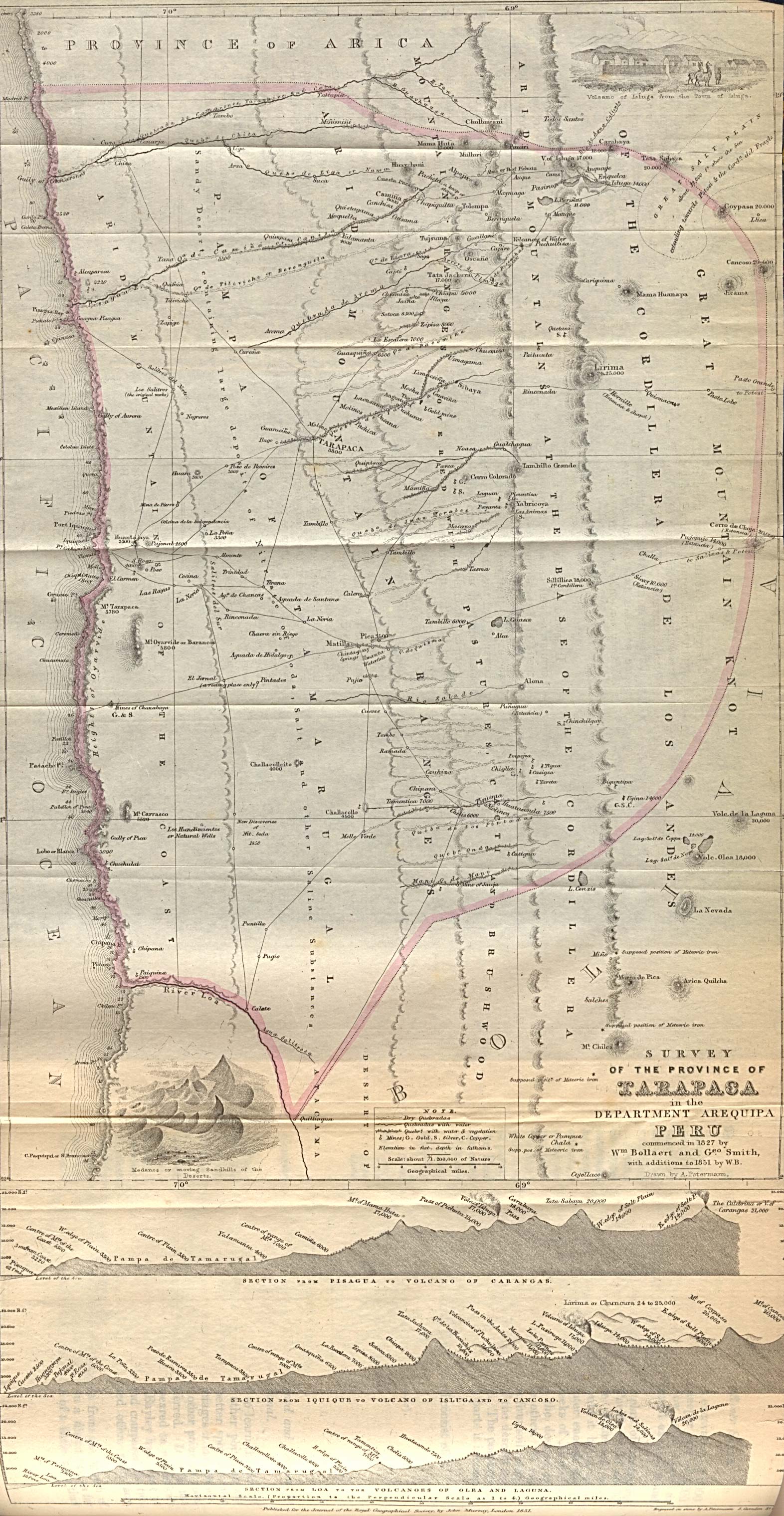
- Survey of the Province of Tarapaca in the Department of Arequipa Peru commenced in 1827 by Wm. Bollaert and Geo. Smith with additions to 1851 by W.B. In: Journal of the Royal Geographical Society of London, Vol. 21, (1851).
- Progress of the African Mission, Consisting of Messrs. Richardson, Barth, and Overweg, to Central Africa. In: Journal of the Royal Geographical Society of London, Vol. 21, (1851), pp. 130–221, 2 maps.
- Notes on the Distribution of Animals Available as Food in the Arctic Regions. In: Journal of the Royal Geographical Society of London, Vol. 22, (1852), pp. 118–127.
- Sir John Franklin, the Sea of Spitzbergen, and Whale-Fisheries in the Arctic Regions. In: Journal of the Royal Geographical Society of London, Vol. 23, (1853), pp. 129–136, 2 maps.
- Map of part of northern Africa showing the routes of the expedition under Messrs. Richardson, Barth, Overweg & Vogel in the years 1850 and 1853. London, E. Stanford, 1854.
- Australia and New Zealand according to Arrowsmith and Mitchell. Edinburgh ; London ; Dublin : A. Fullarton & Co., [1858?]. (several editions).
- The Grecian Archipelago according to the English Admirality Survey 1828–1849, drawn by Augustus Petermann, engraved by G.H.Swanston, published by Fullerton circa 1860.
- Australia and New Zealand. Edinburgh ; London ; Dublin : A. Fullarton & Co., [186-?].
- Peru-Bolivian Tablelands’’; Chiefly according to Pentland, Parish, Fitzroy Meyen, Arrowsmith &c. &c. Constructed by Augustus Petermann, F.R.G.S. Engraved by G.H. Swanston. Maps 2–4: Chile according to Admiralty Surveys, United States Expn. by J. Bartholomew Junr. F.R.G.S.
- Journey of M. Gerhard Rohlfs Through Marocco and Tuat, 1863–64. In: Proceedings of the Royal Geographical Society of London, Vol. 9, No. 2 (1864–1865), pp. 79–80
- On the Proposed Expedition to the North Pole. In: Proceedings of the Royal Geographical Society of London, Vol. 9, No. 3 (1864–1865), pp. 90–104.
- Second Letter to Sir Roderick I. Murchison, on the Subject of North Polar Exploration. In: Proceedings of the Royal Geographical Society of London, Vol. 9, No. 4 (1864–1865), pp. 114–125.
- The Northern and Central states of Germany, drawn by Augustus Petermann, F.R.G.S., engraved by J. Bartholomew, published by A. Fullarton & Co, London & Edinburgh, c. 1870.
- On the Exploration of the North Polar Region. In: Proceedings of the Royal Geographical Society of London, Vol. 12, No. 2 (1867–1868), pp. 92–113.
- British Guayana / according to Sir Robert Schomburgk drawn by Augustus Petermann F.R.G.S. Engraved by G.H. Swanston. A. Fullarton & Co. London, Edinburgh & Dublin, 1872.
- Caucausus & Crimea with the Northern Portions of the Black & Caspian Seas, IX. (with) Crimea according to Huot & Demidoff. Drawn & Engraved by J. Bartholomew, Edinburgh. (with) The Caucasus according to Profr. Dr. Karl Koch, with additions from other Sources by Augustus Petermann, F.R.G.S. Engraved by G.H. Swanston. A. Fullarton & Co. London, Edinburgh & Dublin. 1872.
- Danish Islands in the North Atlantic Ocean. XII. (with) Iceland according to the Trigon Survey of Gunnlaugsson drawn by Augustus Petermann F.R.G.S. Engraved by G.H. Swanston. 1872.
- Exploration of the Arctic Regions. In: Proceedings of the Royal Geographical Society of London, Vol. 19, No. 2 (1874–1875), pp. 173–180
- Important Points in Central African Explorations”. In: Journal of the American Geographical Society of New York, Vol. 7, (1875), pp. 324–328.
- Germany = Deutschland / Constructed by Augustus Petermann ; Peter & Galpin ; engraved by I. Dower. London, Ward & Lock. 1880.
It is no surprise to see that his sphere of interest in ‘current’ geography, was only sharpened when paired with his updating of Stieler’s Hand-Atlas. In stressing the geographic nature of cartography, he showed himself more a Humboldtian than a follower of Ritter’s political-historical school.
M. Linke et al. wrote in 1986: “There seems to be no doubt that Petermann’s work contributed to the high standards of British cartography during these years. T.W. Freeman has noted that ‘Fine maps had been produced in the 1851 Census by August Heinrich Petermann during his long stay in Britain (1845–54) with the Johnston map firm in Edinburgh and later in London, but since his departure the standard has declined’ ”.
In 1852 and 1853 Petermann published some maps on cholera in Britain, explaining that the map, better than tables, can show the progress and victim density of the disease, following the example set by Heinrich Berghaus in his Physikalischer Atlas, Band II, Abt. VIII, no. 2 (1847). These were later followed by Keith Johnston in the second edition of The physical atlas of natural phenomena (1856) .
Start-up of the journal
"From the early 1850s Petermann maintained private and business contacts with the two Gotha publishers Wilhelm and Bernhardt Perthes, and in June 1853 he actually spent a short time in Gotha.". Financial difficulties and several other factors prompted him to accept the Perthes’ offer of work in 1854. Early in his German career here Petermann was appointed first professor (1854) and later honorary doctor (1855) of the University of Göttingen by the Duke of Gotha. Bernhardt Perthes hired him with the prospect of playing an important role in the establishment of his geographical institute. At the same time his friend Henry LangeHenry Lange
-Biography:He was born at Stettin. He worked with Berghaus, and then labored three years in Edinburgh on Alexander Keith Johnston's Physical Atlas. Beginning in 1847, he studied under Carl Ritter and Heinrich Wilhelm Dove in Berlin...
also started to work with Perthes. When he was refused a position equal to Petermann he left Perthes and started to work for Brockhaus in Leipzig.
When Petermann went to the Gotha Institute part of the original plan was that he would revive the Geographisches Jahrbuch (Geographical Yearbook), which Heinrich Berghaus had edited from 1850 to 1852. At the suggestion of the manager Adolf Müller (1820–1880) it was decided instead to publish the monthly Mittheilungen aus Justus Perthes Geographischer Anstalt über wichtige neue Erforschungen auf dem Gesamtgebiet der Geographie von Dr. A. Petermann (PGM) (Communications from the Justus Perthes Geographical Institute concerning important new studies in the whole field of geography, by Dr. A. Petermann). These were to be published in ‘casual issues’. Their relation to several of the Perthes atlases was plainly expounded in the preface to the first issue of 1855:
“Our ‘Communications’ will differ from all similar publications in that they will summarise and graphically illustrate the results of new geographic explorations in precisely executed and carefully detailed maps. Every issue of our periodical will therefore include one or more map supplements, and their design will guarantee a continuous and easily accessible supplement in easy-to-manage form with special regard for those who own Stielers Hand-Atlas, Berghaus’s Physical Atlas, and other map publications of the (Perthes
Justus Perthes
Justus Perthes Publishers in Gotha, Germany was established in 1785. Justus Perthes was Publisher of geographic atlases, ‘’Petermann’s Geographische Mitteilungen’’ and also the Almanach de Gotha,...
) Institute. We will take special care to always present our readers with important new discoveries immediately or as fast as possible.”
In the same preface he put the main focus of the ‘Mittheilungen’ on physical and bio-geography, geology and other natural phenomena, and to a lesser degree on ethnography. Its greatest strength lay in the accompanying maps, for it was thought these would show best the results of geographic exploration. In an age hungry for adventure, but not yet totally scientifically literate, this was the best way to attract the largest possible group of interested readers. The maps not only supplemented several of the Perthes atlases, but were also used as a forum to elaborate on new themes, thus widening the thematic scope of cartography. He expresses his emphasis on maps anew when he writes in the Geographisches Jahrbuch:
"In first instance the end result and final goal of all geographic investigations, explorations, and surveys is the depiction of the earth’s surface: the map. The map is the basis for geography. The map shows us what we know about our earth in the best, clearest and most exact way. The contemporary map should so depict the earth’s surface that one can not only measure the horizontal positions of and distances between all points and localities, but also clearly distinguish vertical variations, from sea level to the highest summits."
Petermann was responsible for drawing most of the maps in the first few years of the journal. His strength was in the analysis and evaluation of all sources available. As such one can say that the indication ‘Originalkarte’ (original map) in many titles was well earned, for few slavishly copied what explorers or other experts had sketched. German geographers, like Hermann Wagner (1840–1929), claimed that in other geographical journals explorer's maps were just copied instead of having them evaluated by cartographers first. Maps based on recent exploration reports were always, when possible, complemented with route maps from previous expeditions. He did not like to infer or extrapolate from the sources, for that might give inaccurate measurements, so many of his maps show large blank spaces. How right he was in this respect was demonstrated in 1911 when Julien Thoulet drafted bathymetric maps for the territory of France. In these four maps he draws hypothetical isobaths, which are based on respectively 15, 31, 154, and 308 altitude measurements per 153821 square miles (398,394.6 km²) for France and the adjacent territories. (A reasonable amount of measuring points for precipitation and temperature maps would be 1,500 and 600 per 100,000 km² respectively to create acceptable isoline maps for these phenomena). These give schematic negative relief maps, which hardly even approximate the true relief of the territory. Thoulet wanted to show that the few bathymetric measurements available for the vast oceans would only vaguely approximate the true relief of the ocean floors. Petermann must have had the same idea intuitively for his exploratory maps. He was keen, however, to introduce spot heights and spot depths in the maps he drafted in order that others could benefit from them.
Technical innovations
Having understood well from his teacher, Heinrich Berghaus, the merit of the metric scale he introduced the representative fraction as map scale, without discarding, however, the verbal better known or local scale. The popular acceptance of the metric system and Greenwich as prime meridian was slower in the uptake. Only with the ninth edition of Stieler’s Hand-Atlas (1900–1905) was this process completed.In 1870 Petermann advocated the use of a red and blue color scheme for temperature maps of the oceans.
Although the number of projection methods increased at a reasonable rate, a few well-known sorts, like the stereographic
Stereographic projection
The stereographic projection, in geometry, is a particular mapping that projects a sphere onto a plane. The projection is defined on the entire sphere, except at one point — the projection point. Where it is defined, the mapping is smooth and bijective. It is conformal, meaning that it...
and orthographic equatorial
Orthographic projection (cartography)
An orthographic projection is a map projection of cartography. Like the stereographic projection and gnomonic projection, orthographic projection is a perspective projection, in which the sphere is projected onto a tangent plane or secant plane. The point of perspective for the orthographic...
projections and the projections of Lambert
Johann Heinrich Lambert
Johann Heinrich Lambert was a Swiss mathematician, physicist, philosopher and astronomer.Asteroid 187 Lamberta was named in his honour.-Biography:...
, Flamsteed and Mercator
Mercator projection
The Mercator projection is a cylindrical map projection presented by the Belgian geographer and cartographer Gerardus Mercator, in 1569. It became the standard map projection for nautical purposes because of its ability to represent lines of constant course, known as rhumb lines or loxodromes, as...
, remained the most popular. Petermann did publish reports on the new projection methods of J. Babinet
Mollweide projection
The Mollweide projection is a pseudocylindrical map projection generally used for global maps of the world . Also known as the Babinet projection, homalographic projection, homolographic projection, and elliptical projection...
(1854) and J. James (1857), and G. Jäger, but he hardly used them. Though Petermann and Ernst Behm (1830–1884; like many of the famous Gothaer geographers and cartographers Behm had first another profession. He was a physician, who learned the geographic trade in practice) wrote many articles about geodesy
Geodesy
Geodesy , also named geodetics, a branch of earth sciences, is the scientific discipline that deals with the measurement and representation of the Earth, including its gravitational field, in a three-dimensional time-varying space. Geodesists also study geodynamical phenomena such as crustal...
and surveying
Surveying
See Also: Public Land Survey SystemSurveying or land surveying is the technique, profession, and science of accurately determining the terrestrial or three-dimensional position of points and the distances and angles between them...
, they rarely got involved in other technical and theoretical cartographic issues.
Petermann concerned himself much more with printing technology, especially colour-lithography. Although they produced many color maps in this way in the 1870s, more and more maps returned to hand coloring, for it then became cheaper than lithography. According to Stams, the Gotha Institute may have produced some 2,500,000 hand-colored maps for all its cartographic products in a decade, or 800 per day! In his last article published before his death, Petermann speaks enthusiastically about the newly developed photogravure
Photogravure
Photogravure is an intaglio printmaking or photo-mechanical process whereby a copper plate is coated with a light-sensitive gelatin tissue which had been exposed to a film positive, and then etched, resulting in a high quality intaglio print that can reproduce the detail and continuous tones of a...
, which considerably reduced costs per map while also increasing production speed. In his opinion the 715-sheet Austrian map was probably twenty times more efficiently produced than an engraved version would have been, for its production took only a fifth of the time and a fourth of the costs.
In 1857 the President of the Royal Geographical Society, Sir Roderick Murchison
Roderick Murchison
Sir Roderick Impey Murchison, 1st Baronet KCB DCL FRS FRSE FLS PRGS PBA MRIA was a Scottish geologist who first described and investigated the Silurian system.-Early life and work:...
, praised PGM for its fast reporting of diverse explorations, and spoke against the jealousy of those in his own Society who felt that exploration supported primarily by the British should first be published in Britain: he thought the Perthes Institute enriched the scientific geographic discourse.
'Petermann school' also known as 'Gotha school'
Since he was not appointed head of the Perthes establishment Petermann could only guide the other skills available. Fortunately he could call on cartographers and engravers who had developed their skills through long experience with men like Adolf StielerAdolf Stieler
Adolf Stieler was a German cartographer who worked most of his life in the Justus Perthes Geographical Institute in Gotha.His atlases are deservedly held in high esteem for their excellence...
, Stülpnagel, Heinrich Berghaus
Heinrich Berghaus
Heinrich Berghaus was a German geographer.-Life:Berghaus was born at Kleve. He was trained as a surveyor, and after volunteering for active service under General Tauentzien in 1813, joined the staff of the Prussian trigonometrical survey in 1816...
, Emil von Sydow
Emil von Sydow
Emil von Sydow was a German geographer and cartographer born in Freiberg, Saxony. Early in his career he was a geography instructor at the military academy in Erfurt, and in 1867 became director of statistics and geography to the Prussian General Staff.Emil von Sydow is considered to be the...
, etc., as well as new cartographers like Carl Vogel and Hermann Berghaus. According to Hermann Wagner it was not felt wise to have any of these employees appointed as head of the establishment. Instead the firm was led by Adolf Müller, not a cartographer, but an economic manager.
The cartographers Petermann trained included Bruno Hassenstein
Bruno Hassenstein
Bruno Hassenstein was a German cartographer who was born in Ruhla, Thuringia.From 1854 he worked and studied cartography under August Petermann in Gotha. Here he drew numerous maps for Petermann's geographical journal- Mittellungen, and became known for his outstanding work performed on maps of...
(1839–1902), Hermann Habenicht (1844–1917, who from 1897 onwards trained Hermann Haack, the 20th-century editor of PGM), Ernst Debes (1840–1923. He could have come to rival Carl Vogel, but in 1868 he left the Gotha Institute to co-found his own firm, [Heinrich] Wagner & Debes, which published one of the six famous families of German reference atlases E. Debes neuer Handatlas, later called Grosser Columbus Weltatlas), Carl Barich, Arnim Welcker (1840–1859), Ludwig Friederichsen (who worked on the Stieler and PGM from 1859 to 1863, and later founded the geographical society of Hamburg and became very active in German colonial politics.) in the 1850s, and Fritz Hanemann (1847–1877), Christian Peip (1843–1922), Bruno Domann and Otto Koffmahn (1851–1916) in the 1860s. They soon learned to produce maps as good as their teacher’s, and eventually even better. But they had probably listened well when Petermann pointed out the need for an improvement in map lettering, in elevation figures (though elevation and bathymetric figures were common in topographic maps and charts, Petermann was the first to include them in geographic maps), more accurate engraving and better coloring, for under his directions the maps of the Stieler became more uniform in expression. In this they were also guided by the more than consistent work of Vogel, and Von Sydow’s critical remarks concerning the advantages and disadvantages of certain styles in his Kartographischen Standpunkt Europas.
Petermann was also keen to use physical characteristics as background for thematic maps, an idea followed by his pupils. When Herbert Louis demanded in 1960 that the terrain underlying thematic maps should indicate elevations, hydrological networks, settlements and traffic roads, he cited Petermann as the first cartographer who used a terrain map as basis for population maps. By using hachuring as a basis for his Karte des Österreichischen Kaiserstaates zur Übersicht der Dichtigkeit der Bevölkerung nach dem Census von 1857 (Map of the Austrian imperial state as an overview of the population density after the 1857 census, 1860) and the map Die Ausdehnung der Slaven in der Türkei und den angrenzenden Gebieten (Expansion of the Slavic populations in Turkey and adjacent territories, 1869) Petermann continued the representation of geological, climatological and ethnographical data that his teacher Heinrich Berghaus had begun two decades before.
Sections
From the start, the journal contained small messages concerning developments in geography under the heading Geographische Notizen/Monatsbericht (1855–....). Some of these were concerned with recently published literature, mainly book citations. In 1860 Petermann decided that these should be listed in a more structured way, the latter temporarily as Geographischer Literatur Bericht für ****(1886–1909), maybe inspired by Kroner’s literature lists in the Zeitschrift für allgemeine Erdkunde of the ‘Gesellschaft für Erdkunde’. Books and maps would not merely be listed, but also reviewed, if they were part of the Perthes library. Unlike most listings it would also cover articles from the main journals, for these, he noted, were the primary sources reflecting the most recent developments in geography. This would keep the readers of PGM up to date.Other sections of the journal were: Geographische Nekrologie des Jahres **** (1858–1884), Geographie und Erforschung Polar-Regionen (nr. 51/1871-nr. 135/1878), Monatsbericht über Entdeckungsgeschichte und Kolonisation (1885), Kleinere Mitteilungen (1889–1939), Geographischer Anzeiger (1899–1902), Kartographischer Monatsbericht aus Justus Perthes' Geographischer Anstalt in Gotha (1908–1911), Militärkartographie (1909–1914), Staaten und Völker (1923), Neue Forschung im Felde (1935–1939), (Wehr- und) Militärgeographie (1935–1936), Kartographie (1941–1945).
Mapping the unknown
Though Petermanns name appears on hundreds of maps, Wagner suggests he stopped drafting maps himself after 1862. The report concerning the NordenskiöldAdolf Erik Nordenskiöld
Freiherr Nils Adolf Erik Nordenskiöld , also known as A. E. Nordenskioeld was a Finnish baron, geologist, mineralogist and arctic explorer of Finnish-Swedish origin. He was a member of the prominent Finland-Swedish Nordenskiöld family of scientists...
voyage to the Lena
Lena River
The Lena is the easternmost of the three great Siberian rivers that flow into the Arctic Ocean . It is the 11th longest river in the world and has the 9th largest watershed...
, and the maps of the United States and Australia, suggest this may not be true. Perhaps he no longer designed, constructed and drafted the maps, as he had with the Barth maps, but he most likely continued to play a role in the conception and design of the maps, especially those in his fields of interest.
Petermann was very well aware that even topographic maps were not yet a true representation of reality (this is illustrated by the depiction of the Liparian Isles, which were not securely situated until Darondeau’s French survey in 1858), let alone medium- and small-scale maps of the interior of continents and the polar regions. One could still hardly speak of dense topographic, orographic and hydrological information. Though the maps in the Stieler looked dense with information they were mainly filled out with information where space in the image allowed, and the cartographers had little choice what to depict by the lack of known phenomena. The density of information did not indicate how thoroughly an area had been explored, for the cartographers selected their data and drafted the maps in such a way as to give a balanced image as possible. As Petermann put it in 1866:
“In fact, our cartographic knowledge of the territories of the earth is far less than is generally supposed. … [In the maps,] even the African and Australian terrae incognitae shrink more and more, and there remain [only] a few blank spots, maybe 'wild territories', where there is 'nothing'. In reality everything we see on our maps is just the first step, the beginning of a more accurate knowledge of the earth’s surface.”
Only in the detailed maps in PGM, where lots of spaces were left blank, could one really judge how haphazard and incomplete the geographic knowledge was. J.G. Bartholomew in 1902 phrased Petermann's drive as: "The filling up of the blank spaces of the unknown in his maps had such a fascination for him that rest seemed impossible to him while any country remained unexplored".
The results of the exploratory expeditions cried out for presentation in map form, and PGM published exploration results as quickly and accurately as possible. Petermann had all results he received from explorers checked against the considerable information and maps available in the Perthes Institute. This fund of knowledge grew to be so large that the Institute soon had a large library of manuscripts, books, atlases, and maps at its disposal that could vie with any university or society collection. In the 1980s it was thought that the Perthes-archives contained 180,000 printed maps and around 2,800 atlases. In the 1990s the estimate was 1,000 m of archive, some 400,000 maps (including manuscripts), and some 120,000 geographical works. All collections (currently estimated at 185,000 sheets of maps, 120,000 geographical works, and 800 m of archives) were acquired in 2003 by the Free State of Thüringen and deposited with the library of the University of Erfurht in its research center in Gotha.
But the maps went beyond a simple presentation of the itinerary by also describing the area explored with all knowledge available and pointing out gaps that remained to be filled in the current knowledge. So the impact was reciprocal. Moreover Petermann gave directions to explorers in exchange for which he was allowed to publish their results as soon as possible.
Richardson's African expedition
The influence Petermann tried to wield, even as a young man, can best be illustrated by his interference, together with Bunsen and Ritter, on behalf of Heinrich BarthHeinrich Barth
Heinrich Barth was a German explorer of Africa and scholar.Barth is one of the greatest of the European explorers of Africa, not necessarily because of the length of his travels or the time he spent alone without European company in Africa, but because of his singular character.-Biography:Barth...
, who wished to take part in the Richardson expedition. He later also persuaded the English government to send Eduard Vogel
Eduard Vogel
Eduard Vogel was a German explorer in Central Africa.- Early career :Vogel was born in Krefeld. He studied mathematics, botany and astronomy at Leipzig and Berlin, studying with Encke at the latter institution. In 1851, he was engaged as assistant astronomer to director John Russel Hind at George...
after them for scientific research and astronomical observations. Petermann published the results under the title Account of the expedition to Central-Africa. When first Barth and later Vogel failed to return at the expected time Germany franticly tried to discover their fate, much as Britain had with Franklin in the Arctic area. This led to many new German expeditions to Africa (by Theodor von Heuglin
Theodor von Heuglin
Martin Theodor von Heuglin , was a German explorer and ornithologist.-Biography:...
, Hermann Steudner
Hermann Steudner
Carl Theodor Hermann Steudner was a botanist and an explorer of Africa.- Education and early work :Steudner was born in Greiffenberg, located in Silesia, but grew up in Görlitz. He studied in Berlin and Würzburg botany, mineralogy and medicine...
, Theodor Kinzelbach, Karl Moritz von Beurmann, Gerhard Rohlfs, Karl Mauch and others), most financed by gifts due largely to Petermann’s agitating actions and publications. Many found their death in Africa as shown in the map with the subtitle Four martyrs of German science in Inner-Africa shows, i.c. Overweg, Vogel, Beurmann and Steudner.
Petermann first drafted maps of Barth & Overweg’s routes for the journal of the German Geographical Society and followed these up with maps in PGM in 1855, 1857, and 1859. These were later worked into the maps for Barth’s voluminous work on his African voyage of 1850–55. The route maps were used in new maps up to 1893.
When we compare the maps in Barth’s work and in PGM we may get an idea how the information was turned into images. The first map in Barth’s work gives an overview of his routes. The routes of Livingstone
David Livingstone
David Livingstone was a Scottish Congregationalist pioneer medical missionary with the London Missionary Society and an explorer in Africa. His meeting with H. M. Stanley gave rise to the popular quotation, "Dr...
have already been engraved, but have not been highlighted by coloring. The 1857 issue of PGM uses the same copperplate, but with both routes highlighted and another title. Sheets 2–14 of Barth’s work are route maps on the scale 1:800,000 and 1:1,000,000. In 1855 PGM gives only a summary of the routes of the first half of the total tour, on scale of 1:2,100,000, with added profiles along the borders that do not appear on the detail maps. This was a corrected issue of a map first published in London. In the 1857 issue the map of Touareg-country is a copy, but mainly uncolored. Maps 15 and 16 of Barth’s work form a beautifully drafted and colored two-sheet map at a scale of 1:6,000,000 and measures 57 x 85 cm. It depicts the approximate territories of the indigenous tribes. The other maps in the 1857 issue show rather small details of the routes, not beautifully executed, while in the text a plan of Agades is inserted (I do not know if it exists in Barth’s work). All in all there is little overlap, also because the scales used for the different works are mostly different. But the smaller maps are clearly generalizations of the maps in Barth’s work. The images in Barth’s look sharper, but of course that is also because they are engraved on a larger scale, while all the areas outside the routes, of which nothing or not enough is known are blank.
These routes, like many others, were reused in many new maps, such as Barth’s route, supplemented with the 1828 routes of René-Auguste Caillé (1799–1838) and Léopold Planet (1850).
Invitation for exploring Africa
PGM not only reported the findings of explorers but also was proactive in instigating new explorations. Ergänzungsband II of 1863 contains a 10-part map (210x102 cm) of Africa (Karte von Inner-Afrika, that contained all routes of explorers between 1701 and 1863. The most important parts of the map are the blank areas, hoping that they would stimulate explorers to go on expeditions to find out what new things there could be. But it was also a case of marketing PGM, as shown in the memoire that accompanied the map, where Petermann wrote:"The basic idea of our map was to give travellers a sure support for the choice of their routes and guarantee the direction of the explorations, to resolve doubts and stimulate the elucidation of the unknown, and to offer a means for friends at home to follow their moves and to judge the value of their labour. This by creating a cartographic representation of the least known central regions of Africa utilizing all material at hand as completely as possible, to display the range of our contemporary knowledge as well as the way this knowledge is acquired and the degree of its reliability."
Arctic explorations
Petermann spent a lot of time on the active promotion of his exploratory missions, especially the polar regions. For this he wrote more articles than for any of his other ventures. Up to 1871 he published seventeen maps of the Arctic and Antarctic in the regular issues and eight in the ‘supplement’ issues. He began publishing notices on the geography and exploration of the polar regions in PGM 38, 1871 (Geographie und Erforschung der Polar-Regionen started in 1865 and nos. 51–135 appeared in PGM volumes 16, 1871 to 23, 1878), and from that time onwards 195 maps covered the polar regions, but none appeared in the supplements of that period. He actually started to push his interest in this subject in the 1865 issue of PGM and with the publication of supplement 16 (Ergänzungsband IV) in 1865. In the PGM-issue he recites the correspondence he has with the Royal Geographical Society (RGS) concerning the proposal of capt. Sherard Osborn (1822–1875) to send another English expedition to the North pole starting from Baffin Bay. In several articles he tries to persuade the RGS to support his plan to start the expedition from Spitsbergen and use steamships in stead of sledges for transport. In one article he stresses his love for Arctic expeditions by reminiscing: "Who, like us, e.g. has attended the accounts of one capt. [Edward AugustusNorth-East passage
He not only promoted explorations, but also actively collected funds to realize them, and gave an account of the receipts and expenditures in several issues of PGM. In 1865 Otto Volger of the FDH (Freies Deutsches Hochstift für Wissenschaft, Künste und allgemeine Bildung, founded in 1859) organised the ‘Allgemeine Deutsche Versammlung von Freunden der Erdkunde’ (General German Assembly of Friends of Geography). During this two-day meeting G. Neumayer stressed the fact that Germany needed a German maritime institute to be independent of other nations. One of the programmed issues to be discussed was the issue of guidelines for the use of a homogeneous meteorological logbook for the German merchant navy. In later years the maps in PGM made much use of the data thus gathered. Petermann jealously reported on the marine surveys in Britain and America, which were realized with governmental support, and he dearly wished such was possible in other nations, especially Germany. Furthermore he pointed out that Germany had much to win by exploring the Arctic region, especially the Northeast passage, since the English and Americans were concentrating on the Northwest passage. Though he even tried to get Bismarck involved in an Arctic exploration project, it was shelved for some time because of the Austro Prussian warAustro-Prussian War
The Austro-Prussian War was a war fought in 1866 between the German Confederation under the leadership of the Austrian Empire and its German allies on one side and the Kingdom of Prussia with its German allies and Italy on the...
and the consequent expansion of the Prussian realm. In PGM that same year he again turned to the FDH for support. In 1868 Petermann roused so much support for his idea in the German public that his Arctic expedition actually took place.
He proposed to follow a course East of Greenland
Greenland
Greenland is an autonomous country within the Kingdom of Denmark, located between the Arctic and Atlantic Oceans, east of the Canadian Arctic Archipelago. Though physiographically a part of the continent of North America, Greenland has been politically and culturally associated with Europe for...
, for he and other geographers were convinced that Greenland stretched much farther North than was known in that time. Though Ferdinand von Wrangel started a four year long expedition in 1820 to find possible land North of cape Shelagskiy and couldn’t find any land he noted a Chucki chief saying: “One might in a clear summer’s day descry snow-covered mountains at a great distance to the North.” Heinrich Berghaus, Petermann’s teacher, included this information in the right hand corner on his isotherm map of 1838 for his Physikalische Atlas with the text ‘possible polar land’ [Wahrscheinliches Polar-Land]. So it might be possible that Petermann based his views on this information.
He published the same map of the Arctic and Antarctic as in 1865, but now with Greenland stretching over the Arctic and ending in Wrangel Island
Wrangel Island
Wrangel Island is an island in the Arctic Ocean, between the Chukchi Sea and East Siberian Sea. Wrangel Island lies astride the 180° meridian. The International Date Line is displaced eastwards at this latitude to avoid the island as well as the Chukchi Peninsula on the Russian mainland...
close to the Bering Strait
Bering Strait
The Bering Strait , known to natives as Imakpik, is a sea strait between Cape Dezhnev, Chukotka Autonomous Okrug, Russia, the easternmost point of the Asian continent and Cape Prince of Wales, Alaska, USA, the westernmost point of the North American continent, with latitude of about 65°40'N,...
. It shows the possible route of the German expedition. The Antarctic map now uses only two colors to delimit the areas covered by James Cook
James Cook
Captain James Cook, FRS, RN was a British explorer, navigator and cartographer who ultimately rose to the rank of captain in the Royal Navy...
and others. Later in that volume he published two maps of the route sailed by the German expedition. Unfortunately they discovered a finger of permanent pack ice stretching from the north to approximately 76°, which made progress further North impossible. Since we of course know this only by hindsight we can understand that Petermann was not daunted in his endeavors to reach the North Pole and demonstrate a possible passage to the Pacific Ocean, even when this expedition had partly failed. In 1869 he published a map of the Arctic Ocean North of Wrangel Island with all exploration routes between 1648 and 1867 and a map with sea-temperatures in the Greenland Sea and the Norwegian Sea as observed by the German expedition. And again two maps of the German expedition in Ergänzungsheft 28.
In 1874 he again published an overview map of the Arctic scale 1:16,000,000 now with all the routes from 1616 to the end of 1874, complemented with the new meteorological weather stations. Strangely enough the route of the 1868 German expedition is not engraved in the image. Petermann still believed, however, that Greenland stretched far into the Polar region. The text in the map reads: ‘Unerforscht, wahrscheinlich Land oder Inseln (Petermann’s Hypothese)’ [unexplored, probably land or islands (Petermann’s hypothesis)].
In the case of the polar regions Petermann’s point of view deviated from most contemporary views. While many, especially the Americans and British, saw a possible passage in the Northwest, where they expected to find a passage after rounding Greenland, Petermann thought this not a viable option. But this did not prevent him from publishing many reports and maps of the American and British explorations in this area, sometimes translated from the journal of the Royal Geographical Society and other geographical societies. Though he was right in hypothesizing that the warm Gulf Stream complemented the cold Labrador Stream and that the warm stream extended far north of Spitsbergen and Nova Zembla his thesis that it warmed the Arctic proved erroneous. Though he thought it to be a deep stream he still could not have imagined how deep it really was. On the other hand he was wrong about the extension of Greenland. He wrote:
“… but such an enormous glacier like the one named after Von Humboldt points at extensive eternal snow and glacier regions and this speaks for an extension of Greenland to the North …”
His view may have been reinforced by some explorers who sighted land at higher latitudes than the tip of Greenland.
While Petermann was honored in 1876 by the American Geographical Society, during the last week of a 3 weeks visiting the U.S.A., Dr. Isaac I. Hayes disputed the hypothesis of Petermann’s land tongue stretching from Greenland to the Bering Sea, though he agreed that the Arctic Ocean would possibly be open water. In the Soviet Encyclopaedia the following is written concerning Petermann’s hypothesis:
“He put forward the hypothesis of a warm Arctic sea and the existence of land in the central Arctic, dividing the sea in two. In 1874 Payer ‘viewed’ land north of Franz-Joseph-Land and put it on the map under the designation ‘Petermann Land’. But during the ice drift of the Russian ship ‘Saint Anna’ (1912–1914) and the marches of the navigating officer W.A. Albanow it was established that it did not exist.”
The seemingly impossibility of the Northwest Passage was acknowledged long after his death. Only in 1904 did Roald Amundsen
Roald Amundsen
Roald Engelbregt Gravning Amundsen was a Norwegian explorer of polar regions. He led the first Antarctic expedition to reach the South Pole between 1910 and 1912 and he was the first person to reach both the North and South Poles. He is also known as the first to traverse the Northwest Passage....
achieve the passage. When it came to the Northeast Passage his view that a passage was possible between Nova Zembla
Nova Zembla
Nova Zembla may refer to:* Nova Zembla Island, Nunavut, Canada* Nova Zembla , a 2011 Dutch film* Nova Zembla , a Belgian electronic music label-See also:...
and Spitsbergen
Spitsbergen
Spitsbergen is the largest and only permanently populated island of the Svalbard archipelago in Norway. Constituting the western-most bulk of the archipelago, it borders the Arctic Ocean, the Norwegian Sea and the Greenland Sea...
proved right after Nordenskiöld’s trip to the Ob
Ob River
The Ob River , also Obi, is a major river in western Siberia, Russia and is the world's seventh longest river. It is the westernmost of the three great Siberian rivers that flow into the Arctic Ocean .The Gulf of Ob is the world's longest estuary.-Names:The Ob is known to the Khanty people as the...
and Yenisei river
Yenisei River
Yenisei , also written as Yenisey, is the largest river system flowing to the Arctic Ocean. It is the central of the three great Siberian rivers that flow into the Arctic Ocean...
, and this while encountering stiff opposition and bearing the weight of some failed German expeditions. The ultimate proof by Nordenskiöld’s trip with the steamship ‘Vega’ sailing around the Taimyr peninsula was published in 1879 in PGM shortly after his death. Since the map was drafted on top of Petermann’s earlier map of Siberia, from 1873, I conclude that this might have been a way to honour Petermann. The route of the ‘Vega’ appeared on a Russian copy of Petermann’s 1873 map, which was reason enough for the editors to add it in their 1879 map. The map shows clearly to what degree the descriptive data of older explorations (i.e. Vasili Pronchishchev
Vasili Pronchishchev
Vasili Vasilyevich Pronchishchev was a Russian explorer.In 1718, Vasili Pronchishchev graduated from Moscow School of Mathematics and Navigation and was promoted to naval cadet...
['Prontschischtschew'], 1735–36; Hariton Laptev ['Laptew'], 1739–43; Semyon Čeluskin ['Tscheljuskin'], 1735–43; Fyodor Minin
Fyodor Minin
Fyodor Alekseyevich Minin was a Russian Arctic explorer.In 1730s, Minin participated in the Second Kamchatka expedition. In 1736, he joined the unit led by Dmitry Ovtsyn. In 1738, he was in charge of a group of explorers, that would chart the Arctic Ocean coastline east of the Yenisei river...
and Dmitriy Sterlegov ['Sterlegow'], 1740; and Alexander Theodor von Middendorff, 1843) could be trusted when drafting a map from many sources and trying to amalgamate them into a single image. The difference between the coastlines on the two maps sometimes can be as much as ½° latitude and 1° longitude. Looking at Cape Taimyr, the channel between it and the mainland is reduced from approximately 10 km to a few kilometres by the Swedish exploration! The only exception was the information derived from P.F. Anjou (1823), which was based on astronomical observations, and is the same in both maps. The article (translations from Swedish and Danish with a preamble by Behm) and map appeared four months after the ‘Vega’ had arrived in Irkutsk
Irkutsk
Irkutsk is a city and the administrative center of Irkutsk Oblast, Russia, one of the largest cities in Siberia. Population: .-History:In 1652, Ivan Pokhabov built a zimovye near the site of Irkutsk for gold trading and for the collection of fur taxes from the Buryats. In 1661, Yakov Pokhabov...
. Hassenstein drafted the new map, maybe using the older draft. The title was hammered out of the old copperplate and replaced by a new one, while Nordenskiöld’s data were engraved, and printed in red, making it look like an overlay on the old map. Because of the use of lighter background colors the newer map looks much fresher than the older one, though only six years lay between the two.
Australia
Petermann kept his promise, made in the preface of the first issue of PGM, when he was responsible for the new edition of Stieler’s Hand-Atlas. He also had a weakness for Australia. Up to his death he published some 48 maps concerning exploration in (parts of) Australia, though hardly any of the expeditions bore any German influence. In 1866, when he gave an account of the first issue of the fifth edition (1866–67) of the Stieler, he frequently referred to maps or articles published in PGM. Furthermore he mentions that he is working on four other maps of Australia or parts of it. One of these is his famous eight-sheet map of Australia, scale 1:3,500,000, and the other three are concerned with exploration or based on land-property maps. (Spezialkarte von Neu-Süd-Wales nach den Kataster-Aufnahmen, later published as Spezialkarte eines Theiles von New South Wales (PGM, 12, 1866, table 13); Spezialkarte vom See’ngebiet im Inneren von Australien, later published as Das See’n-Gebiet (Lake District) und die Steinige Wüste (Great Stony Desert) im Innern von Australien (PGM, 13, 1867, table 4); Karte der Entdeckungen im Inneren Australiens, scale 1:2,500,000, which he probably chose not to publish in PGM due to all the new discoveries). In 1871/72 he published the eight-sheet map as Specialkarte von Australien in 8 Blättern in Ergänzungsheft 29 (volume VI) and 30 (volume VII). It is a superb effort to compile all available knowledge in a colored map-image that measures 194x118 cm altogether, and it reminds us of the ten-sheet map of Africa of 1863. Being Petermann he would have liked to have accompanied it with a volume containing its ten-year history of exploration and discoveries, but in order not to raise the retail price of the map he satisfied himself with merely citing the volumes of PGM where the information could be found and providing an accompanying 43-page geographical-statistical compendium by C.E. Meinicke. In 1875 a second revised edition appeared, with a small sample in PGM.We unfortunately do not find his famous six-sheet map of the United States (Neue Karte der Vereinigten Staaten vor Nord-Amerika in 6 Blättern) in the issues of PGM. It was produced for the sixth edition of the Stieler on scale 1:3,700.000, though a small part appeared in the next annual as an illustration of the exploration of Northwest Texas.
Source interpretations
Several times Petermann indicated that he disagreed with the reports of explorers, probably basing his arguments on reports and literature at his disposal or on sound geographic reasoning. In a map, concerning among other things lake Uniamesi (Lake TanganyikaLake Tanganyika
Lake Tanganyika is an African Great Lake. It is estimated to be the second largest freshwater lake in the world by volume, and the second deepest, after Lake Baikal in Siberia; it is also the world's longest freshwater lake...
), he tends to disagree with Jakob Erhardt, one of the missionaries of the Church Mission Society
Church Mission Society
The Church Mission Society, also known as the Church Missionary Society, is a group of evangelistic societies working with the Anglican Communion and Protestant Christians around the world...
of London, concerning its situation and extension. Erhardt was erroneous in that he situated the lower tip of the lake around 13° South 36° East and made it bend westward to 28° East, with a probable extension to 24° East. Furthermore he though that Lake Victoria
Lake Victoria
Lake Victoria is one of the African Great Lakes. The lake was named for Queen Victoria of the United Kingdom, by John Hanning Speke, the first European to discover this lake....
, Lake Tanganyika
Lake Tanganyika
Lake Tanganyika is an African Great Lake. It is estimated to be the second largest freshwater lake in the world by volume, and the second deepest, after Lake Baikal in Siberia; it is also the world's longest freshwater lake...
and Lake Nyassa were one inland sea extending to 6° North. A lack of data led Petermann to agree with his erroneous shape of the lake or lakes, but he was not convinced of its wide extension to the west and north. As for the sources of the Nile he was not so much mistaken, as they were indicated by a text near the equator between 30° and 36° East, but this was not so hard to induce. When one views the ethnographic and trade information in the map and interprets them from a relative topological point of view we can see this as the strength of the missionaries’ reports. As their mission was focused on people and not on the natural environment this kind of information was of great importance to them. But geometrically their information could not be trusted, in part because most of their information was based on verbal reports of the native tribes.
At other times he depicted maps of the same area from several authors together in one supplement map to show the authors’ different interpretations. This was the case with, for example, the map of the Kerguelen and McDonald Islands sighted by John Heard (1853), William MacDonald (1854), Hutton (1854), Attway (1854), Rees (1854), and Neumayer (1857), with several comparisons of explorations since James Cook
James Cook
Captain James Cook, FRS, RN was a British explorer, navigator and cartographer who ultimately rose to the rank of captain in the Royal Navy...
. The same with small maps (scale ca. 1:33,000,000) of the central part of southern Africa, which shows different interpretations by Heinrich Kiepert
Heinrich Kiepert
Heinrich Kiepert , German geographer, was born at Berlin as the son of a wealthy businessman.Already in his youth he traveled with his parents and had a particular interest in the geographic circumstances, which he carefully sketched...
(1855), J. McQueen (1857) and David Livingstone
David Livingstone
David Livingstone was a Scottish Congregationalist pioneer medical missionary with the London Missionary Society and an explorer in Africa. His meeting with H. M. Stanley gave rise to the popular quotation, "Dr...
(1857). Or with the representation of the Gabon countries, which show interpretations by August Petermann, Thomas E. Bowdich, William D. Cooley, Heinrich Kiepert, Paul Belloni du Chaillu and Heinrich Barth
Heinrich Barth
Heinrich Barth was a German explorer of Africa and scholar.Barth is one of the greatest of the European explorers of Africa, not necessarily because of the length of his travels or the time he spent alone without European company in Africa, but because of his singular character.-Biography:Barth...
.
Many times he included an outline map of Germany, or parts thereof or other countries to show the vastness through which the explorers had to travel. This must have contributed to the understanding and compassion the readers felt for the sacrifice and hardships the explorers had to go through to come to the results presented in the articles and maps.
Stieler-Handatlas
Since the first edition Friedrich von Stülpnagel had been mainly responsible for the drafting of the maps of Stieler-HandatlasStielers Handatlas
Stielers Handatlas , formally titled "Hand-Atlas über alle Theile der Erde und über das Weltgebäude" , was the leading German world atlas of the last three decades of the 19th and the first half of the 20th century...
. When Stülpnagel died in 1865 Petermann became responsible for the Stieler. He drafted some maps (e.g. Russland und Skandinavien, Süd-Polar Karte, Neu-Seeland, Australien, Süd-Ost Australien ) for the 4th edition (1863–1867), which reached 83 maps. In the 5th edition (1868–1874) we can see the hand of the master clearer, as the maps become more uniform and the style of the 'Gotha School' becomes more distinct.
Fame for the armchair traveller
Petermann was sometimes accused of being an ‘armchair’ geographer as he never traveled wide or experienced new discoveries with his own eyes, but the quality of the maps and geographic ideas he produced proves the accusation unfair. Some people are better at observing and describing circumstances and phenomena, others are better at interpretation of data. Petermann’s greatest accomplishment lay in the interpretation and evaluation of sometimes contradictory sources, and his great legacy is that he was able to develop this faculty in most of his pupils in such a fine way that geography at large has profited from it ever since. Should one criticize the journal under his direction for not being geographically innovative then one may come nearer to the truth. Lots of articles are of a descriptive physical nature, with lots of intimate details in the explorers’ colloquial style, and hardly any tries to find explanations for the physical phenomena. Most emphasis is laid on geomorphologyGeomorphology
Geomorphology is the scientific study of landforms and the processes that shape them...
and geology
Geology
Geology is the science comprising the study of solid Earth, the rocks of which it is composed, and the processes by which it evolves. Geology gives insight into the history of the Earth, as it provides the primary evidence for plate tectonics, the evolutionary history of life, and past climates...
— old disciplines by then with their own technical language already — meteorology
Meteorology
Meteorology is the interdisciplinary scientific study of the atmosphere. Studies in the field stretch back millennia, though significant progress in meteorology did not occur until the 18th century. The 19th century saw breakthroughs occur after observing networks developed across several countries...
, botany
Botany
Botany, plant science, or plant biology is a branch of biology that involves the scientific study of plant life. Traditionally, botany also included the study of fungi, algae and viruses...
and biology
Biology
Biology is a natural science concerned with the study of life and living organisms, including their structure, function, growth, origin, evolution, distribution, and taxonomy. Biology is a vast subject containing many subdivisions, topics, and disciplines...
. Articles on anthropogeography usually reach no further than ethnographic descriptions of regions. It is still the era of data-gathering and in this they weren’t far beyond the cameralistic nature of the first half of the nineteenth century. One should have expected more articles concerning (parts of) Europe, but a count in the annuals for 1860–1864 shows that only 16% of the articles and 22% of the Kleinere Mitteilungen (small communications) concerned Europe. As accommodation one might say that the journal, though geographic by nature, was aimed at popular use. That was one of its strengths, as shown by its large circulation.
“Petermann’s achievement falls in a period in which raw material was gathered, especially through explorations. It was the flowering of geographic dilettantism. Interest was not only stirred by news as such, but the news in itself was interesting, because every educated person without special prior knowledge could understand it.”
According to Weller Petermann signed 226 articles in Petermanns Geographische Mitteilungen, including 41 on Africa, 98 on the Polar regions and 37 on the history and use of cartography. The same source puts his total production of maps at 535, including his maps for the Stieler, the Physical atlas and several miscellaneous items. Stams, using the ten-year indexes, counts 280 maps in Petermanns Geographische Mitteilungen that can be said to have been constructed and edited by him.
Slipping and death
At the end of the 1870s geography started to change its objects and goals, which upset the previously important position of what was then called the ‘Gotha Academy’. When Charles DarwinCharles Darwin
Charles Robert Darwin FRS was an English naturalist. He established that all species of life have descended over time from common ancestry, and proposed the scientific theory that this branching pattern of evolution resulted from a process that he called natural selection.He published his theory...
published The descent of man
The Descent of Man, and Selection in Relation to Sex
The Descent of Man, and Selection in Relation to Sex is a book on evolutionary theory by English naturalist Charles Darwin, first published in 1871. It was Darwin's second great book on evolutionary theory, following his 1859 work, On The Origin of Species. In The Descent of Man, Darwin applies...
it was the beginning of the expansion of human geography, which till then was only rarely focused upon, except in the field of ethnography. The physical-deterministic view of humanity that followed led to the rise of the branch of geography we now call anthropogeography, especially after 1875, when Friedrich Ratzel (1844–1904) was the first new professor of geography appointed in München and later Leipzig (only Carl Ritter ever before had been professor of geography worldwide).
In 1856 Petermann had married Clara Leslie and had two daughters with her. They were divorced in 1875. A year later he married for the second time. As time wore on he seemed to have suffered more and more from family problems. It is also supposed that for many years he suffered from manic-depressive moods and he seemed to have always kept a revolver in close proximity.
All these changes and troubles may have contributed to the fact that Petermann died by his own hand
Suicide
Suicide is the act of intentionally causing one's own death. Suicide is often committed out of despair or attributed to some underlying mental disorder, such as depression, bipolar disorder, schizophrenia, alcoholism, or drug abuse...
at Gotha on the 25th of September 1878. The fact that Gotha was becoming less exclusively the center of exploration — which so enchanted the large masses — and became more scientifically focused might also have played a role.
In 1902 J.G. Bartholomew wrote: "It is only a fair tribute to Augustus Petermann to say that no one has done more than he to advance modern cartography, and no man has ever left a more fitting monument to himself than his Mitteilungen, which still bears his name, and under the editorship of Dr. Supan, is the leading geographical authority in all countries. But to the absorbing facsination of his work Petermann sacrificed all other interests in life and died a martyr to geography". That fame perished quickly was shown by Hermann Wagner
Hermann Wagner (geographer)
Hermann Wagner was a German geographer and cartographer who was a native of Erlangen. He was the son of anatomist Rudolf Wagner and brother to economist Adolph Wagner ....
in his article of 1912, when he commemorates the merits of the Gotha epoch under Petermann and finds that nobody up till then had written about the making of the history of geography and cartography and that all those pioneers were all but forgotten, even though the journal carried Petermann’s name since 1879.
In 1909 a monument with Petermann’s effigy from the workshop of Max Hoene-München of Gotha was erected in the Ducal gardens of Gotha, a stone’s throw away from the institute where he had worked for so many years. The monument was offered by the German geographical societies. Petermann in his time was well paid by Perthes as is shown by his beautiful villa close to Gotha’s railway station. A fine way to meet his guests, friends, scientists, explorers, etc.
Petermann lives on
Because Petermann provided so much supporting work during his lifetime, several physical features, especially in the Arctic, were named after him. In the NIMA-database the following seven toponyms are listed: Petermann Ranges (Antarctica), Petermann Ranges (Australia)Mittlere Petermann Range
Mittlere Petermann Range is one of the Petermann Ranges, extending north-south for 17 nautical miles from Johnson Peaks to Store Svarthorn Peak, in the Wohlthat Mountains, Queen Maud Land. Discovered and plotted from air photos by German Antarctic Expedition, 1938–39, and so named by them for its...
, Petermann Bjerg (= Fjeld, Peak, Bjaerg, Bjoerg), Petermann Glacier, Petermann Peninsula (= Halvø), Petermannbreen
Petermann glacier
Petermann Glacier is a large glacier located in North-West Greenland to the east of Nares Strait. It connects the Greenland ice sheet to the Arctic Ocean near 81 degrees north latitude. The tidewater glacier consists of a long and wide floating ice tongue whose thickness changes from about at...
(= -Glacier), Petermannfjellet (= Cape). According to Hugo Wichmann, Capt. Bullock was probably the first to name a physical feature after Petermann, on a printed English chart of 1860. In the same report he counts thirteen features in Asia, Australia and New Zealand, and the Arctic and Antarctic regions, named between 1860 and 1874. Some of them were renamed by other explorers and one turned out not to exist, Petermannland, an island North of Zemlya Frantsa-Iosifa (Franz Josef Land) sighted by Capt. Fligely and named by Julius Payer, which later proved nonexistent. We may keep this name in mind, however, as a proof of Petermann’s vision and drive to have the region explored, though this sometimes revealed different physical objects than he had hypothesized. In a later age, even a crater on the moon was given the name Petermann crater
Petermann (crater)
Petermann is a lunar crater that is located near the northern limb of the Moon, on the eastern hemisphere. It is located about 10 kilometres to the north of the crater Cusanus...
, situated halfway between Mare Humboldtianum and Peary in the northern polar region.
Petermann thought that the naming of newly discovered physical features was one of the privileges of a map-editor, especially as he was fed up with forever encountering toponyms like 'Victoria', 'Wellington', 'Smith', 'Jones', etc. He writes: "While constructing the new map to specify the detailed topographical portrayal and after consulting with and authorization of messr. [Theodor] v[on] Heuglin
Theodor von Heuglin
Martin Theodor von Heuglin , was a German explorer and ornithologist.-Biography:...
and count [Karl Graf von Waldburg
The end of an era
In 1993 Justus PerthesJustus Perthes
Justus Perthes Publishers in Gotha, Germany was established in 1785. Justus Perthes was Publisher of geographic atlases, ‘’Petermann’s Geographische Mitteilungen’’ and also the Almanach de Gotha,...
Verlag, the publisher of PGM, was taken over by Ernst Klett Schulbuchverlag in Stuttgart. In 2003 the Perthes archives (180,000 maps, 120,000 geographic publications, and 800 m of business archives) were bought by the Free State of Thüringen and deposited in the Gotha annex of Erfurt University. In 2004, after 149 years of publication, the journal Petermann’s geographische Mitteilungen ceased to be published. The municipality of Gotha bought in 2010 the business premises and the accompanying grounds on Justus-Perthes-Straße 1–9 and Gotthardstraße 6, but has not decided yet what to use them for. Thanks to this initiative many of the letters Petermann sent or received have been saved for future study, as also are the drafts he made for many maps.
Literature
- Jan Smits: Petermann's Maps. Carto-bibliography of the maps in Petermanns Geographische Mitteilungen, 1855–1945. 't Goy-Houten, Hes & De Graaf, 2004. ISBN 90-6194-249-7.
- D.T. Murphy, German exploration of the polar world. A history, 1870–1940 (Nebraska 2002).
More private data concerning August Petermann may be found in :
- Weller, E. 1911. August Petermann: ein Beitrag zur Geschichte der geographischen Entdeckungen der Geographie und der Kartographie im 19. Jahrhundert. Leipzig: Wigand.
External links
- 1872 map by August Petermann, published by Justus Perthes, [Map of Texas, Indian Territory, Louisiana, Arkansas, Missouri, Kansas] / bearbeitet v. H. Habenicht. hosted by the Portal to Texas History.
- DIGMAP Search: “Petermann” gives as of 5 December 2010 some 102 (descriptions of) maps from various libraries and collections in Europe.