
Audubon Park, Kentucky
Encyclopedia
Audubon Park is a city in central Jefferson County
, Kentucky
, United States
. The population was 1,545 at the 2000 census. It is located about 3 miles (4.8 km) south of Downtown Louisville
, and is surrounded on all sides by the city of Louisville. Audubon Park was developed residentially in the early 20th century on 230 acre (0.9307778 km²) of hilly pastureland once owned by General William Preston, who in turn had been granted the land in 1774 from the British Government as payment for his services during the French and Indian War
.
The land was sold to G. Robert Hunt in 1906, and the Audubon Park Country Club was built by avid golfer Russell Houston. The Audubon Park Realty Co. purchased the land in 1912, and named the neighborhood after wildlife painter John James Audubon
, and named all but two of the 20 streets after birds.
Development was very slow until Louisville Gas and Electric laid gas mains and installed streetlights in the 1920s, at which point it was estimated that a new house was begun every 2 weeks. Most houses are traditional in design, with styles including Neo-Colonial, Dutch colonial
and Neo-federal
, though some Craftsman-style California Bungalow
s are present.
An early streetcar spur route ran to a station house near the center of the park (the station house has been converted to a private residence and still stands). The line was discontinued in the 1920s, although the tracks were not entirely removed until 1975. The city incorporated in 1941.
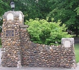
The city is known for its straight, tree lined streets (facilitated by rear utility lines where possible) and six small neighborhood parks. Its entrances are marked by large stone gateways. Two annual traditions are the spring Dogwood
festival, and the fall Arts and Crafts festival. The city was listed on the National Register of Historic Places
in 1996.
According to the United States Census Bureau
, the city has a total area of 0.3 square mile (0.776996433 km²), of which, 0.3 square mile (0.776996433 km²) of it is land and none of it is covered by water.
of 2000, there were 1,545 people, 619 households, and 433 families residing in the city. The population density
was 4,788.6 people per square mile (1,864.1/km²). There were 634 housing units at an average density of 1,965.0 per square mile (765.0/km²). The racial makeup of the city was 98.19% White, 0.26% Black or African American, 0.06% Native American, 0.45% Asian, 0.00% Pacific Islander, 0.13% from other races, and 0.91% from two or more races. 0.52% of the population were Hispanic or Latino of any race.
There were 619 households out of which 30.9% had children under the age of 18 living with them, 59.0% were married couples
living together, 7.6% had a female householder with no husband present, and 30.0% were non-families. 26.0% of all households were made up of individuals and 16.0% had someone living alone who was 65 years of age or older. The average household size was 2.50 and the average family size was 3.05.
In the city the population was spread out with 25.2% under the age of 18, 6.2% from 18 to 24, 24.1% from 25 to 44, 27.0% from 45 to 64, and 17.5% who were 65 years of age or older. The median age was 42 years. For every 100 females there were 94.3 males. For every 100 females age 18 and over, there were 86.2 males.
The median income for a household in the city was $60,000, and the median income for a family was $75,520. Males had a median income of $51,167 versus $32,679 for females. The per capita income
for the city was $31,162. 5.1% of the population and 3.7% of families were below the poverty line. 3.9% of those under the age of 18 and 7.8% of those 65 and older were living below the poverty line.
Jefferson County, Kentucky
As of the census of 2000, there were 693,604 people, 287,012 households, and 183,113 families residing in the county. The population density was . There were 305,835 housing units at an average density of...
, Kentucky
Kentucky
The Commonwealth of Kentucky is a state located in the East Central United States of America. As classified by the United States Census Bureau, Kentucky is a Southern state, more specifically in the East South Central region. Kentucky is one of four U.S. states constituted as a commonwealth...
, United States
United States
The United States of America is a federal constitutional republic comprising fifty states and a federal district...
. The population was 1,545 at the 2000 census. It is located about 3 miles (4.8 km) south of Downtown Louisville
Downtown Louisville
Downtown Louisville is the largest central business district in the Commonwealth of Kentucky and the urban hub of the Louisville, Kentucky Metropolitan Area. Its boundaries are the Ohio River to the north, Hancock Street to the east, York and Jacob Streets to the south, and 9th Street to the west...
, and is surrounded on all sides by the city of Louisville. Audubon Park was developed residentially in the early 20th century on 230 acre (0.9307778 km²) of hilly pastureland once owned by General William Preston, who in turn had been granted the land in 1774 from the British Government as payment for his services during the French and Indian War
French and Indian War
The French and Indian War is the common American name for the war between Great Britain and France in North America from 1754 to 1763. In 1756, the war erupted into the world-wide conflict known as the Seven Years' War and thus came to be regarded as the North American theater of that war...
.
The land was sold to G. Robert Hunt in 1906, and the Audubon Park Country Club was built by avid golfer Russell Houston. The Audubon Park Realty Co. purchased the land in 1912, and named the neighborhood after wildlife painter John James Audubon
John James Audubon
John James Audubon was a French-American ornithologist, naturalist, and painter. He was notable for his expansive studies to document all types of American birds and for his detailed illustrations that depicted the birds in their natural habitats...
, and named all but two of the 20 streets after birds.
Development was very slow until Louisville Gas and Electric laid gas mains and installed streetlights in the 1920s, at which point it was estimated that a new house was begun every 2 weeks. Most houses are traditional in design, with styles including Neo-Colonial, Dutch colonial
Dutch Colonial
Dutch Colonial is a style of domestic architecture, primarily characterized by gambrel roofs having curved eaves along the length of the house...
and Neo-federal
Federal architecture
Federal-style architecture is the name for the classicizing architecture built in the United States between c. 1780 and 1830, and particularly from 1785 to 1815. This style shares its name with its era, the Federal Period. The name Federal style is also used in association with furniture design...
, though some Craftsman-style California Bungalow
California Bungalow
California bungalows, known as Californian bungalows in Australia and are commonly called simply bungalows in America, are a form of residential structure that were widely popular across America and, to some extent, the world around the years 1910 to 1939.-Exterior features:Bungalows are 1 or 1½...
s are present.
An early streetcar spur route ran to a station house near the center of the park (the station house has been converted to a private residence and still stands). The line was discontinued in the 1920s, although the tracks were not entirely removed until 1975. The city incorporated in 1941.
The city is known for its straight, tree lined streets (facilitated by rear utility lines where possible) and six small neighborhood parks. Its entrances are marked by large stone gateways. Two annual traditions are the spring Dogwood
Dogwood
The genus Cornus is a group of about 30-60 species of woody plants in the family Cornaceae, commonly known as dogwoods. Most dogwoods are deciduous trees or shrubs, but a few species are nearly herbaceous perennial subshrubs, and a few of the woody species are evergreen...
festival, and the fall Arts and Crafts festival. The city was listed on the National Register of Historic Places
National Register of Historic Places
The National Register of Historic Places is the United States government's official list of districts, sites, buildings, structures, and objects deemed worthy of preservation...
in 1996.
Geography
Audubon Park is located at 38°12'18" North, 85°43'39" West (38.204970, -85.727598).According to the United States Census Bureau
United States Census Bureau
The United States Census Bureau is the government agency that is responsible for the United States Census. It also gathers other national demographic and economic data...
, the city has a total area of 0.3 square mile (0.776996433 km²), of which, 0.3 square mile (0.776996433 km²) of it is land and none of it is covered by water.
Demographics
As of the censusCensus
A census is the procedure of systematically acquiring and recording information about the members of a given population. It is a regularly occurring and official count of a particular population. The term is used mostly in connection with national population and housing censuses; other common...
of 2000, there were 1,545 people, 619 households, and 433 families residing in the city. The population density
Population density
Population density is a measurement of population per unit area or unit volume. It is frequently applied to living organisms, and particularly to humans...
was 4,788.6 people per square mile (1,864.1/km²). There were 634 housing units at an average density of 1,965.0 per square mile (765.0/km²). The racial makeup of the city was 98.19% White, 0.26% Black or African American, 0.06% Native American, 0.45% Asian, 0.00% Pacific Islander, 0.13% from other races, and 0.91% from two or more races. 0.52% of the population were Hispanic or Latino of any race.
There were 619 households out of which 30.9% had children under the age of 18 living with them, 59.0% were married couples
Marriage
Marriage is a social union or legal contract between people that creates kinship. It is an institution in which interpersonal relationships, usually intimate and sexual, are acknowledged in a variety of ways, depending on the culture or subculture in which it is found...
living together, 7.6% had a female householder with no husband present, and 30.0% were non-families. 26.0% of all households were made up of individuals and 16.0% had someone living alone who was 65 years of age or older. The average household size was 2.50 and the average family size was 3.05.
In the city the population was spread out with 25.2% under the age of 18, 6.2% from 18 to 24, 24.1% from 25 to 44, 27.0% from 45 to 64, and 17.5% who were 65 years of age or older. The median age was 42 years. For every 100 females there were 94.3 males. For every 100 females age 18 and over, there were 86.2 males.
The median income for a household in the city was $60,000, and the median income for a family was $75,520. Males had a median income of $51,167 versus $32,679 for females. The per capita income
Per capita income
Per capita income or income per person is a measure of mean income within an economic aggregate, such as a country or city. It is calculated by taking a measure of all sources of income in the aggregate and dividing it by the total population...
for the city was $31,162. 5.1% of the population and 3.7% of families were below the poverty line. 3.9% of those under the age of 18 and 7.8% of those 65 and older were living below the poverty line.