

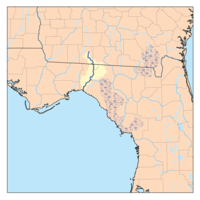
Aucilla River
Encyclopedia
Thomasville, Georgia
Thomasville is the county seat of Thomas County, Georgia, United States. The city is the second largest in Southwest Georgia after Albany.The city deems itself the City of Roses and holds an annual Rose Festival. The town features plantations open to the public, a historic downtown, a large...
, Georgia
Georgia (U.S. state)
Georgia is a state located in the southeastern United States. It was established in 1732, the last of the original Thirteen Colonies. The state is named after King George II of Great Britain. Georgia was the fourth state to ratify the United States Constitution, on January 2, 1788...
, USA, and passes through the Big Bend
Big Bend (Florida)
The Big Bend of Florida, U.S.A., is an informal region of the state with no official surveyed boundary. It includes part of the counties of the Florida Panhandle. Geologists prefer to characterize Florida’s Big Bend as the drowned karst section of the coast that occurs between the mouth of the...
region of Florida
Florida
Florida is a state in the southeastern United States, located on the nation's Atlantic and Gulf coasts. It is bordered to the west by the Gulf of Mexico, to the north by Alabama and Georgia and to the east by the Atlantic Ocean. With a population of 18,801,310 as measured by the 2010 census, it...
, emptying into the Gulf of Mexico
Gulf of Mexico
The Gulf of Mexico is a partially landlocked ocean basin largely surrounded by the North American continent and the island of Cuba. It is bounded on the northeast, north and northwest by the Gulf Coast of the United States, on the southwest and south by Mexico, and on the southeast by Cuba. In...
at Apalachee Bay
Apalachee Bay
Apalachee Bay is a bay in the northeastern Gulf of Mexico occupying an indentation of the Florida coast to the west of where the Florida peninsula joins the United States mainland. It is bordered by Taylor, Jefferson, Wakulla and Franklin counties. The Aucilla, Econfina, St. Marks and Ochlocknee...
. The river is 89 miles (143.2 km) long and has a drainage basin
Drainage basin
A drainage basin is an extent or an area of land where surface water from rain and melting snow or ice converges to a single point, usually the exit of the basin, where the waters join another waterbody, such as a river, lake, reservoir, estuary, wetland, sea, or ocean...
of 747 square miles (1,934.7 km²). The Wacissa River
Wacissa River
The Wacissa River is a large, spring-fed stream located in south-central Jefferson County, Florida. Its headwaters are located about a mile south of the town of Wacissa, where the river emerges crystal clear from a group of large limestone springs...
is a tributary. In Florida
Florida
Florida is a state in the southeastern United States, located on the nation's Atlantic and Gulf coasts. It is bordered to the west by the Gulf of Mexico, to the north by Alabama and Georgia and to the east by the Atlantic Ocean. With a population of 18,801,310 as measured by the 2010 census, it...
, the Aucilla River forms the eastern border of Jefferson County
Jefferson County, Florida
Jefferson County is a county located in the U.S. state of Florida. As of 2000, the population is 12,902. The U.S. Census Bureau 2005 estimate for the county is 14,490 . Its county seat is Monticello, Florida....
, separating it from Madison County
Madison County, Florida
Madison County is a county located in the state of Florida. As of 2000, the population was 18,733. The U.S. Census Bureau 2005 estimate for the county is 19,902. Its county seat is Madison, Florida. Madison County is one of Florida's five dry counties....
on the northern part, and from Taylor County
Taylor County, Florida
Taylor County is a county located in the state of Florida. As of 2000, the population was 19,256. The U.S. Census Bureau 2005 estimate for the county was 19,622 . Its county seat is Perry, Florida.- History :Taylor County was created in 1856...
to the south. The lower part of the river disappears underground and reappears several times, and is known as the Aucilla River Sinks. The Aucilla River is a rich source of late Pleistocene
Pleistocene
The Pleistocene is the epoch from 2,588,000 to 11,700 years BP that spans the world's recent period of repeated glaciations. The name pleistocene is derived from the Greek and ....
and early Holocene
Holocene
The Holocene is a geological epoch which began at the end of the Pleistocene and continues to the present. The Holocene is part of the Quaternary period. Its name comes from the Greek words and , meaning "entirely recent"...
animal bones and human artifacts
Artifact (archaeology)
An artifact or artefact is "something made or given shape by man, such as a tool or a work of art, esp an object of archaeological interest"...
, and is the subject of the Aucilla River Prehistory Project, which includes the Page-Ladson prehistory site
Page-Ladson prehistory site
The Page-Ladson prehistory site is a deep hole in the bed of the Aucilla River that has stratified deposits of late Pleistocene and early Holocene animal bones and human artifacts reaching back to about 14,500 to 12,500 calendar years Before Present...
.The Apalachee lived close to the Aucilla River.
Crossings
| Crossing | Carries | Location | Coordinates |
|---|---|---|---|
Georgia |
|||
 GA 122 GA 122 |
Thomasville Thomasville, Georgia Thomasville is the county seat of Thomas County, Georgia, United States. The city is the second largest in Southwest Georgia after Albany.The city deems itself the City of Roses and holds an annual Rose Festival. The town features plantations open to the public, a historic downtown, a large... |
||
| (road unknown) | Thomasville Thomasville, Georgia Thomasville is the county seat of Thomas County, Georgia, United States. The city is the second largest in Southwest Georgia after Albany.The city deems itself the City of Roses and holds an annual Rose Festival. The town features plantations open to the public, a historic downtown, a large... |
||
 US 84 US 84U.S. Route 84 U.S. Route 84 is an east–west United States highway. It started as a short Georgia-Alabama route in the original 1926 scheme, but now extends all the way to Colorado. The highway's eastern terminus is a short distance east of Midway, Georgia, at an intersection with I-95. The road continues...  GA 38 GA 38 |
Eason | ||
| Rail bridge | CSX CSX Transportation CSX Transportation operates a Class I railroad in the United States known as the CSX Railroad. It is the main subsidiary of the CSX Corporation. The company is headquartered in Jacksonville, Florida, and owns approximately 21,000 route miles... |
Tallahassee Tallahassee, Florida Tallahassee is the capital of the U.S. state of Florida. It is the county seat and only incorporated municipality in Leon County, and is the 128th largest city in the United States. Tallahassee became the capital of Florida, then the Florida Territory, in 1824. In 2010, the population recorded by... |
|
 GA 33 GA 33 |
Boston Boston, Georgia Boston is a city in Thomas County, Georgia, United States. The population was 1,417 at the 2000 census.-Geography:Boston is located at .According to the United States Census Bureau, the city has a total area of , all of it land.... |
||
| (Bridge S of Boston, road unknown) | |||
| Twelve Mile Post Road | Grooverville Grooverville, Georgia Groovervile is an unincorporated community in Brooks County, Georgia, United States.-Geography:Grooverville is located at .It is a circular area radius from the crossing of Liberty Church Road and Grooverville Road :... |
||
Florida |
|||
| Sneads Smokehouse Lake | Jefferson CR 146 | Ashville | |
 US 90 US 90U.S. Route 90 U.S. Route 90 is an east–west United States highway. Despite the "0" in its route number, U.S. 90 never was a full coast-to-coast route; it has always ended at Van Horn, Texas. A short-lived northward extension to U.S... |
Aucilla Aucilla, Florida Aucilla is an unincorporated community in Jefferson County, Florida, United States. It is located near the intersection of County Road 158 and County Road 257.-Geography:Aucilla is located at .... |
||
| Rail bridge | CSX CSX Transportation CSX Transportation operates a Class I railroad in the United States known as the CSX Railroad. It is the main subsidiary of the CSX Corporation. The company is headquartered in Jacksonville, Florida, and owns approximately 21,000 route miles... |
||
 Interstate 10 Interstate 10Interstate 10 Interstate 10 is the fourth-longest Interstate Highway in the United States, after I-90, I-80, and I-40. It is the southernmost east–west, coast-to-coast Interstate Highway, although I-4 and I-8 are further south. It stretches from the Pacific Ocean at State Route 1 in Santa Monica,... |
|||
| Abandoned bridge | Seven Bridges Road | ||
 US 19 US 19U.S. Route 19 U.S. Route 19 is a north–south U.S. Highway. Despite encroaching Interstate Highways, the route has remained a long-haul route, connecting the Gulf of Mexico with Lake Erie....  US 27 US 27U.S. Route 27 U.S. Route 27 is a north–south United States highway in the southern and midwestern United States. The southern terminus is at US 1 in Miami, Florida. The northern terminus is at Interstate 69 in Fort Wayne, Indiana... |
Lamont Lamont, Florida Lamont is an unincorporated community in Jefferson County, Florida, United States.-Geography:Lamont is located at .Ted Turner's Avalon Plantation is located in Lamont.... |
||
| Walker Springs Bridge | Jefferson CR 257 Taylor CR 14 |
||
| Burnt Bridge | (abandoned) | Cabbage Grove | |
| (Natural bridge of sorts, river underground in this area) |
Goose Pasture Road | Goose Pasture | |
 US 98 US 98U.S. Route 98 U.S. Route 98 is an east–west United States highway that runs from western Mississippi to southern Florida. It was established in 1933 as a route between Pensacola, Florida and Apalachicola, Florida, and has since been extended westward into Mississippi and eastward across the Florida... |
Nutall Rise | ||