

Auburn Dam
Encyclopedia
Auburn Dam was a proposed dam on the North Fork of the American River
east of the town of Auburn, California
in the United States
, on the border of Placer
and El Dorado
Counties. Slated to be completed in the 1970s by the U.S. Bureau of Reclamation, the concrete arch-gravity dam would have been over 700 feet (213.4 m) high, straddling a gorge downstream of the confluence of the North and Middle Forks of the American River and upstream of Folsom Lake
. It would have regulated water flow and provided flood control in the American River basin as part of Reclamation's immense Central Valley Project
.
Proposals and studies for the dam emerged in the late 1960s, and construction work commenced in 1968, involving the diversion of the North Fork American River through a tunnel and the construction of a massive earthen cofferdam
. Following a nearby earthquake and the discovery of a seismic fault that underlay the dam site, work on the project was halted for fears that the dam's design would not allow it to survive a major quake on the same fault zone. Although the dam was redesigned and a new proposal submitted by 1980, spiraling costs and limited water storage offered by either design put an end to the project until heavy floods destroyed the cofferdam, sparking brief renewed interest in the dam. The California State Water Resources Control Board denied water rights for the dam project in 2008 due to lack of implementation.
Although new proposals surfaced from time to time after the 1980s, the dam was never built for a variety of reasons. Limited flood-control capability, geologic instability, and potential harm on recreational and ecological values finally put an end to the Auburn Dam project. Many of the original groundworks and preliminary constructions at the Auburn Dam site still exist, and up to 2007, the North Fork American River still flowed through the diversion tunnel that had been constructed in preparation for the dam. Reclamation and Placer County Water Agency completed a pump station project that year which blocked the tunnel, returned the river to its original channel, and diverted water through another tunnel under Auburn to meet local needs. However, some groups continue to support construction of the dam, which they claim would provide important water regulation and flood protection.
was rapidly growing around the confluence of the Sacramento River
and its tributary the American River
, near the middle of the Central Valley of California. The city's increasing population necessitated the construction of an extensive system of levee
s on the two rivers to prevent flooding, especially on the American. The flood control works were not enough to keep the rivers within their beds, however; in 1862, the city was inundated so completely that the state government was temporarily moved to San Francisco. In 1956, the U.S. Army Corps of Engineers built the Folsom Dam
on the lower American, near the confluence of its North and South Forks, to provide flood control for the Sacramento metropolitan area. However, the Folsom Dam provided inadequate flood storage, and overflowed on several occasions since its construction. In fact, a flood in 1955 filled the Folsom Reservoir to capacity, before the dam was even completed.
Water demand in the Central Valley in the Sacramento area was also growing, mainly for agricultural usage. In 1854, a diversion dam was constructed on the North Fork American River at the site of Auburn Dam, to divert water into a series of ditches that supplied irrigation water for downstream farms. Irrigation with dam and canal systems was favored because severe flow fluctuations in Central Valley rivers created floods in some years and droughts in others. It was in this light that the Auburn Dam was first contrived. As early as the 1950s, plans for a giant dam at the Auburn site were already being considered, in the name of flood control. Several designs, both earthfill and concrete, were considered. Before the dam could be built, however, the Auburn-Foresthill Road, which crossed the river just upstream of the dam site, had to be relocated. Even before the project was authorized, several companies had already taken contracts for the construction of a high bridge to carry the road over the proposed reservoir and preliminary excavations at the dam site.
Auburn Dam was to be a massive flood-control and storage structure on the North Fork of the American River, just upstream from Folsom Reservoir. It would create a reservoir with more than twice the capacity of Folsom, which could help reduce floods on the American. With the introduction of the Central Valley Project
in the mid-1930s, came the Auburn-Folsom South Unit, with the purpose to "provide new and supplemental water for irrigation, municipal and industrial use, and to replenish severely depleted ground water in the Folsom South region". In 1965, Congress authorized the Auburn-Folsom South Unit of the Central Valley Project, the primary feature of which was to be Auburn Dam. The targeted completion date was 1973.
As the proposals for the Auburn Dam evolved, the project saw a transformation from a purely flood-control structure to a multipurpose high dam that would serve various purposes including storage, hydroelectricity generation, and recreational activities. One of the first ideas, publicized in the late 1950s, called for a 515 feet (157 m) embankment dam impounding 1000000 acre.ft of water. In 1963, a 690 feet (210.3 m) earthfill dam holding back 2500000 acre.ft of water was proposed. The pre-construction design was finalized in 1967, for a concrete thin-arch gravity structure over 680 feet (207.3 m) high. This dam would be 4200 feet (1,280.2 m) long, 196 feet (59.7 m) thick at the base, and equipped with five 150MW generators at its base for a total generating capacity of 700 MW. Two concrete-lined flip bucket spillway
s would abut both sides of the dam. Construction work for the dam started in late 1968.
 Official groundbreaking
of the Auburn Dam started on October 19, 1968 with preparatory excavations and test shafts drilled into the mountainsides of the North Fork American River gorge. The contract for the diversion tunnel through the mountainside on river left, 33 feet (10.1 m) in diameter, 2400 feet (731.5 m) long, and equipped to handle a flow of 74000 cuft/s (a roughly 35-year flood) was given to Walsh Western for about $5.1 million in 1968. The actual construction of the tunnel itself did not begin until mid-1971, and the tunnel was completed in late November 1972. One construction worker was killed during the excavation of the tunnel. In 1975, the earthen cofferdam for the Auburn project, 265 feet (80.8 m) high, was completed and water began to flow into the diversion tunnel later that year. The diversion tunnel bypassed a roughly 1 miles (1.6 km) section of the riverbed for construction of the main dam.
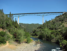
Upstream of the dam site, Auburn-Foresthill Road, one of the only all-weather thoroughfares of the region, would have been inundated by the proposed reservoir. In preparation for the reservoir's filling, the road was raised high above the canyon on a three-spanned, 2428 feet (740.1 m)-long truss bridge rising 730 feet (222.5 m) above the river. Even though the Auburn Dam was never built, the bridge was still required because the pool behind the cofferdam would inundate the old Foresthill crossing anyway, especially during high water. It also improved safety and reduced travel time by eliminating a steep, narrow and winding grade into the canyon on either side of the river, as comparisons to maps showing the old road alignment will attest. The contracts for various projects pertaining to the relocation of the roadway were given to O.K. Mittry and Sons, Hensel Phelps Construction Company, and Willamette-Western Corporation, the latter for the construction of the actual bridge. The Foresthill Bridge
, which still stands today, was completed in 1973.
in 1975, about 50 miles (80.5 km) north of the Auburn Dam construction site. This quake concerned geologists and engineers working on the project so much that the Auburn Dam construction was brought to a complete standstill while the site was resurveyed and investigations conducted into the origins of the earthquake. It was discovered that the quake might have been caused by reservoir-induced seismicity, i.e. the weight of the water from Lake Oroville
, whose dam had been completed in 1968, was pressing down on the fault zone enough to cause geologic stress, upon which the fault might slip and cause an earthquake. As the concrete thin-arch design of the Auburn Dam would be vulnerable to such a quake, the project had to be drastically redesigned.
Over the next few years, while all construction was halted, Reclamation conducted evaluations of the seismic potential of the dam site, even though these delays caused the cost of the project to rise with every passing year. Studies concluded that a major fault system underlay the vicinity of the Auburn Dam site, with many folds of metamorphic rock formed by the contact of the foothills rocks and the granite batholith
of the Sierra Nevada. Reclamation predicted that the Auburn Reservoir could induce an earthquake of up to a 6.5, while the U.S. Geologic Survey came out with a higher magnitude of 7.0. Nevertheless, Reclamation redesigned the Auburn Dam based on their 6.5 figure, even though a 7.0 would be three times stronger. The design for the Auburn Dam was changed to a concrete thick-arch gravity dam, to provide better protection against a possible earthquake induced by its own reservoir.
Through the rest of the 1970s, possible designs were looked at but never implemented, while preliminary work on the construction site was resumed. On April 29, 1979, the foundations for the Auburn Dam were completed. However, debates continued over whether to build an arched or straight-axis dam, the latter of which was proposed because it might be less of an engineering challenge and withstand earthquakes better.
Rivers through the Sacramento Valley, and the city of Sacramento was spared by a close margin. Folsom Lake again filled to capacity, and began spilling 134000 cuft/s by late February.
The flood rapidly filled the pool behind the Auburn cofferdam to capacity, as the diversion tunnel could not handle the extra water pouring into the reservoir. At about 9:00 A.M. on February 18, the rising water overtopped the cofferdam near the right abutment, creating a waterfall that quickly eroded into the structure. Although the cofferdam was designed with a soft earthen plug to fail in a controlled manner if any such event were to occur, the outflow reached 100000 cuft/s by noon; several hours later the maximum discharge was reached at 250000 cuft/s, completely inundating the construction site and destroying almost half of the cofferdam. When the 265 feet (80.8 m) high cofferdam collapsed, its backed-up water surged downstream into already-spilling Folsom Reservoir less than a mile downstream, deposited the dam debris and raised the lake level suddenly. Folsom Dam outflow exceeded the design capacity of levees downstream from re-regulating Nimbus Dam downstream from Folsom, but the levees were not overtopped and severe flooding was avoided through Sacramento. The flood events spurred renewed interest in the Auburn Dam, since a permanent dam would have helped Folsom Dam store water without the flood from behind the cofferdam, but it became clear that the system of levees, dams and diversions on the American River needed to be re-engineered.
, for example, reveals that the Auburn would store very little water compared to its structural size. Lake Mead
, the reservoir behind Hoover, stores about 28500000 acre.ft of water. The proposed Auburn Reservoir, with a mere 8% of that capacity, would require the construction of a dam not only as tall as Hoover but over three times as wide.
As early as 1980, the cost of building the Auburn Dam was estimated at $1 billion. As of 2007, the cost to build the dam would be about $10 billion. Other flood-control works to raise the height and improve the spillway capacity of Folsom Dam, and to increase the capacity of levees in the Sacramento area, would cost significantly less while providing protection against the same floods. Also, the United States National Research Council
believes that existing flood records, which have been in place less than 200 years, are insuffient to justify the construction of a dam as large as Auburn. Finally, water from Auburn Dam, if connected to the long-unfinished Folsom South Canal as originally planned by Reclamation, would be costly and in unreliable supply as the annual inflows to the reservoir would be a relatively modest 1600000 acre.ft or 2097 cuft/s, even though the river poses a high flood threat.
A Bureau of Reclamation study released in 1980 proved that a failure of Auburn Dam would result in a giant wave reaching Folsom Lake within five minutes, and most likely would cause a cascading failure of Folsom and Nimbus Dam
s downstream as well within an hour, unleashing millions of acre-feet of water which would cause far greater damage downstream than any possible natural flood. Folsom would collapse or at least get severely overtopped; Nimbus Dam would be overtopped by 70 feet (21.3 m) of water; and the California State Capitol
would be under 40 feet (12.2 m) of water, as would be much of the rest of the Sacramento metropolitan area. In 1975, a study predicted that a failure of Folsom Dam alone would result in over 250,000 fatalities. With Auburn Dam's capacity added in, the resulting flood would be over three times larger, and cause even greater damage, inundating land for miles on either side of the American and Sacramento rivers.
, which surrounds the former dam site. The reservoir would inundate this popular recreational haven, and cause the silting and destruction of riverbeds and rapids in the canyons. Trails, including those for the Tevis Cup
and Western States Endurance Run
, would be among the ones submerged. The Auburn Reservoir would also result in the destruction of thousands of acres of riverine habitat, and the inundation of historic and archaeological sites.
In the end, the Auburn Dam project, once referred to as "the dam that wouldn't die" and "with more lives than an alley cat", was defeated by the intervention of environmentalists, conservationists, and cost-conscious economists. Although four bills to revive the dam project were introduced in Congress over the next twenty years, all were turned down. Representative Norman D. Shumway introduced the Auburn Dam Revival Act of 1987, which was rejected because of the phenomenally high costs. A flood control bill in 1988 involving the Auburn Dam was also defeated. In 1992 and 1996, plans for restarting the Auburn project appeared in various water projects bills. However, even though the project was now leaning towards purely flood-control instead of the original expensive multipurpose that environmental groups had opposed, both were denied. As the years dragged on, the cost of the project grew, and it officially ended with the revoking of USBR water rights to the site by the state on November 11, 2008.
Although the Auburn Dam is now mostly considered history, there are still proponents and groups devoted to restarting the long-inactive project. Advocates argue that the construction of Auburn would be the only solution for providing much-needed flood protection to the Sacramento area; that millions of dollars have already been spent making preparations; that it would provide an abundant supply of reliable water and hydroelectricity; and also that the recreational areas lost under the reservoir could be rebuilt around it. A major supporter of the revival of the dam is the Sacramento County Taxpayer's League; a recent survey revealed that up to two-thirds of Sacramento citizens support construction of the Auburn. They also argue that the dam would only cost $2.6 billion instead of $6–10 billion, and that it is the cheapest alternative to provide flood control for the American River.
Area Congressman John Doolittle
was one of the largest proponents of the Auburn Dam, and he appropriated several million dollars for funds to conduct feasibility studies for the dam. About $3 million went into the main feasibility report, and the remaining $1 million was used for a study concerning the relocation of California State Route 49
, which runs through the site. After the Hurricane Katrina
disaster in 2005, Doolittle drew public attention to the flood vulnerability of the Sacramento region. He also used the flood-protection "incompetence" of the Folsom Dam to his advantage, saying that "without an Auburn Dam we could soon be in the unenviable position of suffering from both severe drought and severe flooding in the very same year." He led all 18 Republican members of the California House of Representatives in a protest in 2008, trying to convince Governor Arnold Schwarzenegger
to revoke the water-rights decision that California had made against Reclamation. Doolittle is sometimes known as the Auburn Dam's "chief sponsor".
In response to public outcry, most pro-Auburn Dam groups now recommend the construction of a "dry dam", or one that purely supports the purpose of flood control. Such a dam would stand empty most of the year, but during a flood the excess flow would pool temporarily behind the dam instead of flowing straight through, and therefore the dam could still provide flood control while leaving the American River canyons dry for most of the year (hence "dry"). Water would be impounded for only a few days or weeks each year instead of all year long, minimizing damage on the local environment. The dam would be built to protect against a 500-year flood. Also, with the construction of a "dry" Auburn Dam, Folsom Lake could be kept at a higher level throughout the year because of reduced flood-control pressure, therefore facilitating recreational access to the reservoir. Finally, regulations in flow could help groundwater recharge efforts; the lower Sacramento Valley aquifer is acknowledged as severely depleted.
In recent decades, California has been struck with a severe series of droughts. In order to facilitate continued deliveries of water to the thirsty southern half of the state, the Central Valley and State Water Projects have been forced to cut water supplies for agriculture in much of the San Joaquin Valley
. Annual deficits of water in the state are projected to rise from 1600000 acre.ft in 1998 to an estimated 2900000 acre.ft by 2025. The state has proposed three or four solutions to the shortfall. One, the Peripheral Canal, would facilitate water flow from the water-rich north to the dry south, but has never been built due to environmental concerns. The raising of Shasta Dam
on the Sacramento or New Melones Dam
on the Stanislaus
, or the building of Sites Reservoir, has also been proposed. Lastly, the Auburn Dam has also been revived in light of this. According to supporters, it would cause the least environmental destruction of the multitude of choices, and would give the most reliable water yield, regardless of its skyrocketing costs.
A pumping station to supply water to the Placer County Water Agency was built in 2006 on the Middle Fork American River, supplying 100 cuft/s to a northwest-running pipeline. The capacity of the station is eventually expected to be upgraded to 225 cuft/s. By 2006, the Bureau of Reclamation itself began to restore the dam site, which then had been untouched for more than a decade. The river diversion tunnel was sealed but not filled in, and the remnants of the construction site in the riverbed as well as the remains of the cofferdam excavated out of the canyon. After the riverbed was leveled and graded, an artificial riverbed with manmade Class III rapids was constructed to channel the river through the site. The restoration project also included the construction of other recreational amenities in the Auburn site. This act was seen as the final step of decommissioning the Auburn project and shelving it forever.
American River
The American River is a California watercourse noted as the site of Sutter's Mill, northwest of Placerville, California, where gold was found in 1848, leading to the California Gold Rush...
east of the town of Auburn, California
Auburn, California
Auburn is the county seat of Placer County, California. Its population at the 2010 census was 13,330. Auburn is known for its California Gold Rush history.Auburn is part of the Greater Sacramento area.- History :...
in the United States
United States
The United States of America is a federal constitutional republic comprising fifty states and a federal district...
, on the border of Placer
Placer County, California
Placer County is a county located in both the Sacramento Valley and Sierra Nevada regions of the U.S. state of California, in what is known as the Gold Country. It stretches from the suburbs of Sacramento to Lake Tahoe and the Nevada border. Because of the expansion of the Greater Sacramento,...
and El Dorado
El Dorado County, California
El Dorado County is a county located in the historic Gold Country in the Sierra Nevada Mountains and foothills of the U.S. state of California. The 2010 population was 181,058. The El Dorado county seat is in Placerville....
Counties. Slated to be completed in the 1970s by the U.S. Bureau of Reclamation, the concrete arch-gravity dam would have been over 700 feet (213.4 m) high, straddling a gorge downstream of the confluence of the North and Middle Forks of the American River and upstream of Folsom Lake
Folsom Lake
Folsom Lake is a reservoir in Northern California about northeast of Sacramento in Placer, El Dorado, and Sacramento Counties. The lake is formed by Folsom Dam, constructed in 1955 to control the American River. The dam and lake are part of the Folsom Project, which also includes the Nimbus...
. It would have regulated water flow and provided flood control in the American River basin as part of Reclamation's immense Central Valley Project
Central Valley Project
The Central Valley Project is a Bureau of Reclamation federal water project in the U.S. state of California. It was devised in 1933 in order to provide irrigation and municipal water to much of California's Central Valley—by regulating and storing water in reservoirs in the water-rich northern...
.
Proposals and studies for the dam emerged in the late 1960s, and construction work commenced in 1968, involving the diversion of the North Fork American River through a tunnel and the construction of a massive earthen cofferdam
Cofferdam
A cofferdam is a temporary enclosure built within, or in pairs across, a body of water and constructed to allow the enclosed area to be pumped out, creating a dry work environment for the major work to proceed...
. Following a nearby earthquake and the discovery of a seismic fault that underlay the dam site, work on the project was halted for fears that the dam's design would not allow it to survive a major quake on the same fault zone. Although the dam was redesigned and a new proposal submitted by 1980, spiraling costs and limited water storage offered by either design put an end to the project until heavy floods destroyed the cofferdam, sparking brief renewed interest in the dam. The California State Water Resources Control Board denied water rights for the dam project in 2008 due to lack of implementation.
Although new proposals surfaced from time to time after the 1980s, the dam was never built for a variety of reasons. Limited flood-control capability, geologic instability, and potential harm on recreational and ecological values finally put an end to the Auburn Dam project. Many of the original groundworks and preliminary constructions at the Auburn Dam site still exist, and up to 2007, the North Fork American River still flowed through the diversion tunnel that had been constructed in preparation for the dam. Reclamation and Placer County Water Agency completed a pump station project that year which blocked the tunnel, returned the river to its original channel, and diverted water through another tunnel under Auburn to meet local needs. However, some groups continue to support construction of the dam, which they claim would provide important water regulation and flood protection.
Early history
In the 1950s, the city of SacramentoSacramento, California
Sacramento is the capital city of the U.S. state of California and the county seat of Sacramento County. It is located at the confluence of the Sacramento River and the American River in the northern portion of California's expansive Central Valley. With a population of 466,488 at the 2010 census,...
was rapidly growing around the confluence of the Sacramento River
Sacramento River
The Sacramento River is an important watercourse of Northern and Central California in the United States. The largest river in California, it rises on the eastern slopes of the Klamath Mountains, and after a journey south of over , empties into Suisun Bay, an arm of the San Francisco Bay, and...
and its tributary the American River
American River
The American River is a California watercourse noted as the site of Sutter's Mill, northwest of Placerville, California, where gold was found in 1848, leading to the California Gold Rush...
, near the middle of the Central Valley of California. The city's increasing population necessitated the construction of an extensive system of levee
Levee
A levee, levée, dike , embankment, floodbank or stopbank is an elongated naturally occurring ridge or artificially constructed fill or wall, which regulates water levels...
s on the two rivers to prevent flooding, especially on the American. The flood control works were not enough to keep the rivers within their beds, however; in 1862, the city was inundated so completely that the state government was temporarily moved to San Francisco. In 1956, the U.S. Army Corps of Engineers built the Folsom Dam
Folsom Dam
Folsom Dam is a concrete gravity dam on the American River in Northern California, about northeast of Sacramento. Folsom Dam is high concrete and long, flanked by earthen wing dams...
on the lower American, near the confluence of its North and South Forks, to provide flood control for the Sacramento metropolitan area. However, the Folsom Dam provided inadequate flood storage, and overflowed on several occasions since its construction. In fact, a flood in 1955 filled the Folsom Reservoir to capacity, before the dam was even completed.
Water demand in the Central Valley in the Sacramento area was also growing, mainly for agricultural usage. In 1854, a diversion dam was constructed on the North Fork American River at the site of Auburn Dam, to divert water into a series of ditches that supplied irrigation water for downstream farms. Irrigation with dam and canal systems was favored because severe flow fluctuations in Central Valley rivers created floods in some years and droughts in others. It was in this light that the Auburn Dam was first contrived. As early as the 1950s, plans for a giant dam at the Auburn site were already being considered, in the name of flood control. Several designs, both earthfill and concrete, were considered. Before the dam could be built, however, the Auburn-Foresthill Road, which crossed the river just upstream of the dam site, had to be relocated. Even before the project was authorized, several companies had already taken contracts for the construction of a high bridge to carry the road over the proposed reservoir and preliminary excavations at the dam site.
Auburn Dam was to be a massive flood-control and storage structure on the North Fork of the American River, just upstream from Folsom Reservoir. It would create a reservoir with more than twice the capacity of Folsom, which could help reduce floods on the American. With the introduction of the Central Valley Project
Central Valley Project
The Central Valley Project is a Bureau of Reclamation federal water project in the U.S. state of California. It was devised in 1933 in order to provide irrigation and municipal water to much of California's Central Valley—by regulating and storing water in reservoirs in the water-rich northern...
in the mid-1930s, came the Auburn-Folsom South Unit, with the purpose to "provide new and supplemental water for irrigation, municipal and industrial use, and to replenish severely depleted ground water in the Folsom South region". In 1965, Congress authorized the Auburn-Folsom South Unit of the Central Valley Project, the primary feature of which was to be Auburn Dam. The targeted completion date was 1973.
As the proposals for the Auburn Dam evolved, the project saw a transformation from a purely flood-control structure to a multipurpose high dam that would serve various purposes including storage, hydroelectricity generation, and recreational activities. One of the first ideas, publicized in the late 1950s, called for a 515 feet (157 m) embankment dam impounding 1000000 acre.ft of water. In 1963, a 690 feet (210.3 m) earthfill dam holding back 2500000 acre.ft of water was proposed. The pre-construction design was finalized in 1967, for a concrete thin-arch gravity structure over 680 feet (207.3 m) high. This dam would be 4200 feet (1,280.2 m) long, 196 feet (59.7 m) thick at the base, and equipped with five 150MW generators at its base for a total generating capacity of 700 MW. Two concrete-lined flip bucket spillway
Spillway
A spillway is a structure used to provide the controlled release of flows from a dam or levee into a downstream area, typically being the river that was dammed. In the UK they may be known as overflow channels. Spillways release floods so that the water does not overtop and damage or even destroy...
s would abut both sides of the dam. Construction work for the dam started in late 1968.
Site preparation
Groundbreaking
Groundbreaking, also known as cutting, sod-cutting, turning the first sod or a sod-turning ceremony, is a traditional ceremony in many cultures that celebrates the first day of construction for a building or other project. Such ceremonies are often attended by dignitaries such as politicians and...
of the Auburn Dam started on October 19, 1968 with preparatory excavations and test shafts drilled into the mountainsides of the North Fork American River gorge. The contract for the diversion tunnel through the mountainside on river left, 33 feet (10.1 m) in diameter, 2400 feet (731.5 m) long, and equipped to handle a flow of 74000 cuft/s (a roughly 35-year flood) was given to Walsh Western for about $5.1 million in 1968. The actual construction of the tunnel itself did not begin until mid-1971, and the tunnel was completed in late November 1972. One construction worker was killed during the excavation of the tunnel. In 1975, the earthen cofferdam for the Auburn project, 265 feet (80.8 m) high, was completed and water began to flow into the diversion tunnel later that year. The diversion tunnel bypassed a roughly 1 miles (1.6 km) section of the riverbed for construction of the main dam.
Upstream of the dam site, Auburn-Foresthill Road, one of the only all-weather thoroughfares of the region, would have been inundated by the proposed reservoir. In preparation for the reservoir's filling, the road was raised high above the canyon on a three-spanned, 2428 feet (740.1 m)-long truss bridge rising 730 feet (222.5 m) above the river. Even though the Auburn Dam was never built, the bridge was still required because the pool behind the cofferdam would inundate the old Foresthill crossing anyway, especially during high water. It also improved safety and reduced travel time by eliminating a steep, narrow and winding grade into the canyon on either side of the river, as comparisons to maps showing the old road alignment will attest. The contracts for various projects pertaining to the relocation of the roadway were given to O.K. Mittry and Sons, Hensel Phelps Construction Company, and Willamette-Western Corporation, the latter for the construction of the actual bridge. The Foresthill Bridge
Foresthill Bridge
The Foresthill Bridge over the North Fork of the American River is the highest bridge in the U.S. state of California. It is sometimes referred to as the Auburn-Foresthill Bridge or the Auburn Bridge....
, which still stands today, was completed in 1973.
Earthquake and redesigning
A magnitude 5.7 earthquake shook the Sierra Nevada near Oroville DamOroville Dam
Oroville Dam spans the Feather River about northeast of the city of Oroville, California. It forms Lake Oroville, which stores water for irrigation, flood control, municipal water supply and hydroelectricity generation in California's Sacramento Valley. The dam lies in the foothills of the Sierra...
in 1975, about 50 miles (80.5 km) north of the Auburn Dam construction site. This quake concerned geologists and engineers working on the project so much that the Auburn Dam construction was brought to a complete standstill while the site was resurveyed and investigations conducted into the origins of the earthquake. It was discovered that the quake might have been caused by reservoir-induced seismicity, i.e. the weight of the water from Lake Oroville
Lake Oroville
Lake Oroville, also known as Lake Edmonston, is a reservoir in the U.S. state of California, formed by the Oroville Dam across the Feather River. The lake is situated in the foothills of the Sierra Nevada about northeast of Oroville. At over , it is one of the largest reservoirs in California,...
, whose dam had been completed in 1968, was pressing down on the fault zone enough to cause geologic stress, upon which the fault might slip and cause an earthquake. As the concrete thin-arch design of the Auburn Dam would be vulnerable to such a quake, the project had to be drastically redesigned.
Over the next few years, while all construction was halted, Reclamation conducted evaluations of the seismic potential of the dam site, even though these delays caused the cost of the project to rise with every passing year. Studies concluded that a major fault system underlay the vicinity of the Auburn Dam site, with many folds of metamorphic rock formed by the contact of the foothills rocks and the granite batholith
Batholith
A batholith is a large emplacement of igneous intrusive rock that forms from cooled magma deep in the Earth's crust...
of the Sierra Nevada. Reclamation predicted that the Auburn Reservoir could induce an earthquake of up to a 6.5, while the U.S. Geologic Survey came out with a higher magnitude of 7.0. Nevertheless, Reclamation redesigned the Auburn Dam based on their 6.5 figure, even though a 7.0 would be three times stronger. The design for the Auburn Dam was changed to a concrete thick-arch gravity dam, to provide better protection against a possible earthquake induced by its own reservoir.
Through the rest of the 1970s, possible designs were looked at but never implemented, while preliminary work on the construction site was resumed. On April 29, 1979, the foundations for the Auburn Dam were completed. However, debates continued over whether to build an arched or straight-axis dam, the latter of which was proposed because it might be less of an engineering challenge and withstand earthquakes better.
Cofferdam failure
In early 1986 a huge flood began pouring down from the Sierra Nevada mountains. In what would later be considered one of the largest regional floods in recorded history, Placer County was quickly designated a Federal Disaster Area. Rampaging streams and rivers incurred some $7.5 million in damages within the county. Ten inches (254 mm) of rain fell on the Sacramento region in 11 days. Flooding was so catastrophic, that the rating for the city's systems, supposedly designed to prevent a 125-year flood, was dropped to a 78-year flood. The floods tore out long stretches of levees along the American, Sacramento and FeatherFeather River
The Feather River is the principal tributary of the Sacramento River, in the Sacramento Valley of Northern California. The river's main stem is about long. Its length to its most distant headwater tributary is about . Its drainage basin is about...
Rivers through the Sacramento Valley, and the city of Sacramento was spared by a close margin. Folsom Lake again filled to capacity, and began spilling 134000 cuft/s by late February.
The flood rapidly filled the pool behind the Auburn cofferdam to capacity, as the diversion tunnel could not handle the extra water pouring into the reservoir. At about 9:00 A.M. on February 18, the rising water overtopped the cofferdam near the right abutment, creating a waterfall that quickly eroded into the structure. Although the cofferdam was designed with a soft earthen plug to fail in a controlled manner if any such event were to occur, the outflow reached 100000 cuft/s by noon; several hours later the maximum discharge was reached at 250000 cuft/s, completely inundating the construction site and destroying almost half of the cofferdam. When the 265 feet (80.8 m) high cofferdam collapsed, its backed-up water surged downstream into already-spilling Folsom Reservoir less than a mile downstream, deposited the dam debris and raised the lake level suddenly. Folsom Dam outflow exceeded the design capacity of levees downstream from re-regulating Nimbus Dam downstream from Folsom, but the levees were not overtopped and severe flooding was avoided through Sacramento. The flood events spurred renewed interest in the Auburn Dam, since a permanent dam would have helped Folsom Dam store water without the flood from behind the cofferdam, but it became clear that the system of levees, dams and diversions on the American River needed to be re-engineered.
Economic cost
In the years following the 1980-era floods, some public opinion turned against the Auburn Dam because of its relatively small reservoir capacity related to its size, and the massive estimated cost to finish the project, which was then already rising into the billions of dollars. The best dam sites require a relatively small dam that can store massive amounts of water, and most of those sites in the U.S. have already been taken. A comparison with Hoover DamHoover Dam
Hoover Dam, once known as Boulder Dam, is a concrete arch-gravity dam in the Black Canyon of the Colorado River, on the border between the US states of Arizona and Nevada. It was constructed between 1931 and 1936 during the Great Depression and was dedicated on September 30, 1935, by President...
, for example, reveals that the Auburn would store very little water compared to its structural size. Lake Mead
Lake Mead
Lake Mead is the largest reservoir in the United States. It is located on the Colorado River about southeast of Las Vegas, Nevada, in the states of Nevada and Arizona. Formed by water impounded by the Hoover Dam, it extends behind the dam, holding approximately of water.-History:The lake was...
, the reservoir behind Hoover, stores about 28500000 acre.ft of water. The proposed Auburn Reservoir, with a mere 8% of that capacity, would require the construction of a dam not only as tall as Hoover but over three times as wide.
As early as 1980, the cost of building the Auburn Dam was estimated at $1 billion. As of 2007, the cost to build the dam would be about $10 billion. Other flood-control works to raise the height and improve the spillway capacity of Folsom Dam, and to increase the capacity of levees in the Sacramento area, would cost significantly less while providing protection against the same floods. Also, the United States National Research Council
United States National Research Council
The National Research Council of the USA is the working arm of the United States National Academies, carrying out most of the studies done in their names.The National Academies include:* National Academy of Sciences...
believes that existing flood records, which have been in place less than 200 years, are insuffient to justify the construction of a dam as large as Auburn. Finally, water from Auburn Dam, if connected to the long-unfinished Folsom South Canal as originally planned by Reclamation, would be costly and in unreliable supply as the annual inflows to the reservoir would be a relatively modest 1600000 acre.ft or 2097 cuft/s, even though the river poses a high flood threat.
Failure risk
Due to the seismically active nature of the area, the Auburn Dam would also be at risk for failure from an earthquake, even one that the weight of its reservoir might induce on one of the fault lines that crosses the area, known as the Bear Mountain fault zone. Surface displacement of the ground might range from a few inches/centimeters to 3 foot (0.9144 m) in each direction. Although a new concrete-gravity design by Reclamation was tested to survive a magnitude 6.5 earthquake, it performed poorly under the 7.0 that the USGS had originally estimated.A Bureau of Reclamation study released in 1980 proved that a failure of Auburn Dam would result in a giant wave reaching Folsom Lake within five minutes, and most likely would cause a cascading failure of Folsom and Nimbus Dam
Nimbus Dam
The Nimbus Dam is a base load hydroelectric dam on the American River near Folsom, California. Approximately of water is retained by the dam.- External links :* fact sheet - United States Bureau of Reclamation* - parks.ca.gov...
s downstream as well within an hour, unleashing millions of acre-feet of water which would cause far greater damage downstream than any possible natural flood. Folsom would collapse or at least get severely overtopped; Nimbus Dam would be overtopped by 70 feet (21.3 m) of water; and the California State Capitol
California State Capitol
The California State Capitol is home to the government of California. The building houses the bicameral state legislature and the office of the governor....
would be under 40 feet (12.2 m) of water, as would be much of the rest of the Sacramento metropolitan area. In 1975, a study predicted that a failure of Folsom Dam alone would result in over 250,000 fatalities. With Auburn Dam's capacity added in, the resulting flood would be over three times larger, and cause even greater damage, inundating land for miles on either side of the American and Sacramento rivers.
Fate
Filling of the Auburn Reservoir would result in a two-pronged, 40 miles (64.4 km) lake which would inundate numerous canyons and rapids of the North Fork and Middle Fork of the American River. In 1981, the American River was acknowledged as the most popular recreational river in California. Over one million people visit the canyons of the North and Middle Forks of the American River each year to engage in various recreational activities not least of which include kayaking, rafting, hiking, hunting, biking, horseback riding, gold mining, off-roading, and climbing. 900,000 of these visitors go to the Auburn State Recreation AreaAuburn State Recreation Area
Auburn State Recreation Area is a state park unit of California, USA, along of the North and Middle Forks of the American River. The state recreation area is situated on the border of Placer and El Dorado Counties in the heart of historic Gold Country. The largest city with close proximity is...
, which surrounds the former dam site. The reservoir would inundate this popular recreational haven, and cause the silting and destruction of riverbeds and rapids in the canyons. Trails, including those for the Tevis Cup
Tevis Cup
The Western States Trail Ride, popularly called The Tevis Cup, is a 100-mile endurance ride. The amateur event has been held annually since 1955....
and Western States Endurance Run
Western States Endurance Run
The Western States Endurance Run, known commonly as the Western States 100, is a 100-mile ultramarathon that takes place on trails in California's Sierra Nevada Mountains annually on the last full weekend of June. The race starts at the base of the Squaw Valley ski resort and finishes at the...
, would be among the ones submerged. The Auburn Reservoir would also result in the destruction of thousands of acres of riverine habitat, and the inundation of historic and archaeological sites.
In the end, the Auburn Dam project, once referred to as "the dam that wouldn't die" and "with more lives than an alley cat", was defeated by the intervention of environmentalists, conservationists, and cost-conscious economists. Although four bills to revive the dam project were introduced in Congress over the next twenty years, all were turned down. Representative Norman D. Shumway introduced the Auburn Dam Revival Act of 1987, which was rejected because of the phenomenally high costs. A flood control bill in 1988 involving the Auburn Dam was also defeated. In 1992 and 1996, plans for restarting the Auburn project appeared in various water projects bills. However, even though the project was now leaning towards purely flood-control instead of the original expensive multipurpose that environmental groups had opposed, both were denied. As the years dragged on, the cost of the project grew, and it officially ended with the revoking of USBR water rights to the site by the state on November 11, 2008.
Proposals for resurrecting the Auburn Dam
In part as an alternative to Auburn Dam project, flood control for the lower American River is being improved through the $1 billion Joint Federal Project (a collaboration of the US Bureau of Reclamation and the US Army Corps of Engineers) at Folsom Dam which adds a new lower spillway and strengthens the eight dikes that serve as part of the dam. Additional work proposed includes a possible raise of Folsom Dam several feet to improve its flood control and storage capacity. Key levees downstream have also been improved for flood control in the Sacramento area by the US Army Corps of Engineers and the Sacramento Area Flood Control Agency. Sugar Pine Reservoir, an auxilliary component of the Auburn-Folsom South Project upstream in the watershed, was transferred in title by the Bureau of Reclamation to Foresthill Public Utility District in 2003. As a result of a court decision in 1990 (Hodge Decision), the uses of Reclamation's Folsom South Canal changed further when the Freeport Project came online in 2011 to redivert water supplies for East Bay Municipal Utility District and Sacramento County Water Agency from the Sacramento River instead of from the canal via the lower American River, thereby reducing the need for additional supplies from Auburn Dam to the American River. Anticipated diversions from the Folsom South Canal had previously been reduced when the Sacramento Municipal Utility District decommissioned its Rancho Seco nuclear facility in 1989 and no longer required large quantities of cooling water from the canal.Although the Auburn Dam is now mostly considered history, there are still proponents and groups devoted to restarting the long-inactive project. Advocates argue that the construction of Auburn would be the only solution for providing much-needed flood protection to the Sacramento area; that millions of dollars have already been spent making preparations; that it would provide an abundant supply of reliable water and hydroelectricity; and also that the recreational areas lost under the reservoir could be rebuilt around it. A major supporter of the revival of the dam is the Sacramento County Taxpayer's League; a recent survey revealed that up to two-thirds of Sacramento citizens support construction of the Auburn. They also argue that the dam would only cost $2.6 billion instead of $6–10 billion, and that it is the cheapest alternative to provide flood control for the American River.
Area Congressman John Doolittle
John Doolittle
John Taylor Doolittle , American politician, was a Republican member of the United States House of Representatives from 1991 to 2009, representing . In the 109th Congress, he held a leadership role as the Deputy Whip for the Republican party in the House...
was one of the largest proponents of the Auburn Dam, and he appropriated several million dollars for funds to conduct feasibility studies for the dam. About $3 million went into the main feasibility report, and the remaining $1 million was used for a study concerning the relocation of California State Route 49
California State Route 49
State Route 49 is a north–south state highway in the U.S. state of California that passes through many historic mining communities of the 1849 California gold rush. Highway 49 is numbered after the "49ers", the waves of immigrants who swept into the area looking for gold, and a portion of it...
, which runs through the site. After the Hurricane Katrina
Hurricane Katrina
Hurricane Katrina of the 2005 Atlantic hurricane season was a powerful Atlantic hurricane. It is the costliest natural disaster, as well as one of the five deadliest hurricanes, in the history of the United States. Among recorded Atlantic hurricanes, it was the sixth strongest overall...
disaster in 2005, Doolittle drew public attention to the flood vulnerability of the Sacramento region. He also used the flood-protection "incompetence" of the Folsom Dam to his advantage, saying that "without an Auburn Dam we could soon be in the unenviable position of suffering from both severe drought and severe flooding in the very same year." He led all 18 Republican members of the California House of Representatives in a protest in 2008, trying to convince Governor Arnold Schwarzenegger
Arnold Schwarzenegger
Arnold Alois Schwarzenegger is an Austrian-American former professional bodybuilder, actor, businessman, investor, and politician. Schwarzenegger served as the 38th Governor of California from 2003 until 2011....
to revoke the water-rights decision that California had made against Reclamation. Doolittle is sometimes known as the Auburn Dam's "chief sponsor".
In response to public outcry, most pro-Auburn Dam groups now recommend the construction of a "dry dam", or one that purely supports the purpose of flood control. Such a dam would stand empty most of the year, but during a flood the excess flow would pool temporarily behind the dam instead of flowing straight through, and therefore the dam could still provide flood control while leaving the American River canyons dry for most of the year (hence "dry"). Water would be impounded for only a few days or weeks each year instead of all year long, minimizing damage on the local environment. The dam would be built to protect against a 500-year flood. Also, with the construction of a "dry" Auburn Dam, Folsom Lake could be kept at a higher level throughout the year because of reduced flood-control pressure, therefore facilitating recreational access to the reservoir. Finally, regulations in flow could help groundwater recharge efforts; the lower Sacramento Valley aquifer is acknowledged as severely depleted.
Legacy
Since its inception, hundreds of millions of dollars have been poured into the Auburn Dam project, but no further work has been done since the 1980s. However, the Bureau of Reclamation continues to list the Auburn as a considered alternative for the future of its Auburn-Folsom South Unit project. As of now, massive evidence of the dam's construction still remain in the North Fork American River canyon, specifically the excavations for the abutments and spillway, with the consequences of increased erosion.In recent decades, California has been struck with a severe series of droughts. In order to facilitate continued deliveries of water to the thirsty southern half of the state, the Central Valley and State Water Projects have been forced to cut water supplies for agriculture in much of the San Joaquin Valley
San Joaquin Valley
The San Joaquin Valley is the area of the Central Valley of California that lies south of the Sacramento – San Joaquin River Delta in Stockton...
. Annual deficits of water in the state are projected to rise from 1600000 acre.ft in 1998 to an estimated 2900000 acre.ft by 2025. The state has proposed three or four solutions to the shortfall. One, the Peripheral Canal, would facilitate water flow from the water-rich north to the dry south, but has never been built due to environmental concerns. The raising of Shasta Dam
Shasta Dam
Shasta Dam is an arch dam across the Sacramento River in the northern part of the U.S. state of California, at the north end of the Sacramento Valley. The dam mainly serves long-term water storage and flood control in its reservoir, Shasta Lake, and also generates hydroelectric power...
on the Sacramento or New Melones Dam
New Melones Dam
New Melones Dam is an earth and rock filled dam across the Stanislaus River creating New Melones Lake. Situated between Calaveras and Tuolumne County, California in the Sierra Nevada foothills near Jamestown, the dam was completed in 1979 replacing the old Melones Dam.-Background:The dam was...
on the Stanislaus
Stanislaus River
The Stanislaus River in California is one of the largest tributaries of the San Joaquin River. The river is long and has north, middle and south forks...
, or the building of Sites Reservoir, has also been proposed. Lastly, the Auburn Dam has also been revived in light of this. According to supporters, it would cause the least environmental destruction of the multitude of choices, and would give the most reliable water yield, regardless of its skyrocketing costs.
A pumping station to supply water to the Placer County Water Agency was built in 2006 on the Middle Fork American River, supplying 100 cuft/s to a northwest-running pipeline. The capacity of the station is eventually expected to be upgraded to 225 cuft/s. By 2006, the Bureau of Reclamation itself began to restore the dam site, which then had been untouched for more than a decade. The river diversion tunnel was sealed but not filled in, and the remnants of the construction site in the riverbed as well as the remains of the cofferdam excavated out of the canyon. After the riverbed was leveled and graded, an artificial riverbed with manmade Class III rapids was constructed to channel the river through the site. The restoration project also included the construction of other recreational amenities in the Auburn site. This act was seen as the final step of decommissioning the Auburn project and shelving it forever.