
Athabasca Glacier
Encyclopedia
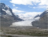
The Athabasca Glacier is one of the six principal 'toes' of the Columbia Icefield
, located in the Canadian Rockies
. The glacier currently recedes at a rate of 2–3 m (6.6–9.8 ft) per year and has receded more than 1.5 km (0.93205910497471 mi) in the past 125 years and lost over half of its volume. The glacier moves down from the icefield at a rate of several centimetres per day.
Due to its close proximity to the Icefields Parkway
, between the Alberta
towns of Banff
and Jasper
, and rather easy accessibility, it is the most visited glacier in North America. The leading edge of the glacier is within easy walking distance; however, travel onto the glacier is not recommended unless properly equipped. Hidden crevasse
s have led to the deaths of unprepared tourists.
The Icefield Interpretive Centre, closed during the winter (mid-October to mid-April), stands across from the glacier. It is used as a lodge and for ticket sales for sightseeing on the glacier. Standard buses transport tourists to the glacier edge, where they board specially designed snow coach
es for transport over the steep grades, snow and ice part way up the glacier.
The glacier is approximately 6 km (3.7 mi) long, covers an area of 6 km² (2.3 sq mi), and is measured to be between 90–300 m (295.3–984.3 ) thick.
Columbia Icefield
The Columbia Icefield is an icefield located in the Canadian Rockies, astride the Continental Divide of North America. The icefield lies partly in the northwestern tip of Banff National Park and the southern end of Jasper National Park. It is about 325 km² in area, 100 to 365 metres in depth and...
, located in the Canadian Rockies
Canadian Rockies
The Canadian Rockies comprise the Canadian segment of the North American Rocky Mountains range. They are the eastern part of the Canadian Cordillera, extending from the Interior Plains of Alberta to the Rocky Mountain Trench of British Columbia. The southern end borders Idaho and Montana of the USA...
. The glacier currently recedes at a rate of 2–3 m (6.6–9.8 ft) per year and has receded more than 1.5 km (0.93205910497471 mi) in the past 125 years and lost over half of its volume. The glacier moves down from the icefield at a rate of several centimetres per day.
Due to its close proximity to the Icefields Parkway
Icefields Parkway
The Icefields Parkway , also known as Highway 93 north, is a scenic road in Alberta, Canada. It parallels the Continental Divide, traversing the rugged landscape of the Canadian Rockies, travelling through Banff National Park and Jasper National Park. It links Lake Louise with Jasper to the north....
, between the Alberta
Alberta
Alberta is a province of Canada. It had an estimated population of 3.7 million in 2010 making it the most populous of Canada's three prairie provinces...
towns of Banff
Banff, Alberta
Banff is a town within Banff National Park in Alberta, Canada. It is located in Alberta's Rockies along the Trans-Canada Highway, approximately west of Calgary and east of Lake Louise....
and Jasper
Jasper, Alberta
Jasper is a specialized municipality in western Alberta, Canada. It is the commercial centre of Jasper National Park, located in the Canadian Rockies in the Athabasca River valley....
, and rather easy accessibility, it is the most visited glacier in North America. The leading edge of the glacier is within easy walking distance; however, travel onto the glacier is not recommended unless properly equipped. Hidden crevasse
Crevasse
A crevasse is a deep crack in an ice sheet rhys glacier . Crevasses form as a result of the movement and resulting stress associated with the sheer stress generated when two semi-rigid pieces above a plastic substrate have different rates of movement...
s have led to the deaths of unprepared tourists.
The Icefield Interpretive Centre, closed during the winter (mid-October to mid-April), stands across from the glacier. It is used as a lodge and for ticket sales for sightseeing on the glacier. Standard buses transport tourists to the glacier edge, where they board specially designed snow coach
Snow coach
A snow coach is a specialized passenger transport vehicle, designed to operate over snow or ice, similar to alarge, multi-passenger snowcat that is equipped with bus style seating. These vehicles may have multiple sets of very large low pressure tires or they may have tracks...
es for transport over the steep grades, snow and ice part way up the glacier.
The glacier is approximately 6 km (3.7 mi) long, covers an area of 6 km² (2.3 sq mi), and is measured to be between 90–300 m (295.3–984.3 ) thick.