
Atakora Department
Encyclopedia
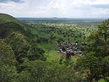
Atakora is the northwestern department
of Benin
, bordering Togo
to the west and Burkina Faso
to the north. Also, it borders the departments of Alibori
, Borgou
, and Donga
. It is the most mountainous region of Benin, and the birth place of the president, Mathieu Kérékou
. It is a much drier area of the country than the south, with 3 major seasons, a rainy season that runs from May or June to September or October, a Harmattan
season of cool, dry winds that runs from October or November to February, and a hot, Famine season that runs from February to April.
Atakora is divided into the communes of Boukoumbé
, Cobly
, Kérou
, Kouandé
, Matéri
, Natitingou
, Pehonko
, Tanguiéta
, and Toucountouna
.
Major towns in the Atakora include Djougou
, Natitingou
and Tanguiéta
, and famous sites to visit include the Tata Somba houses, the Pendjari National Park
, and various waterfalls.
 In 1999 the southern part of Atakora was split off to form the new Donga Department
.
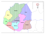
Departments of Benin
||Benin is divided into 12 departments , and subdivided into 77 communes . In 1999, the previous six departments were each split into two halves, forming the current 12...
of Benin
Benin
Benin , officially the Republic of Benin, is a country in West Africa. It borders Togo to the west, Nigeria to the east and Burkina Faso and Niger to the north. Its small southern coastline on the Bight of Benin is where a majority of the population is located...
, bordering Togo
Togo
Togo, officially the Togolese Republic , is a country in West Africa bordered by Ghana to the west, Benin to the east and Burkina Faso to the north. It extends south to the Gulf of Guinea, on which the capital Lomé is located. Togo covers an area of approximately with a population of approximately...
to the west and Burkina Faso
Burkina Faso
Burkina Faso – also known by its short-form name Burkina – is a landlocked country in west Africa. It is surrounded by six countries: Mali to the north, Niger to the east, Benin to the southeast, Togo and Ghana to the south, and Côte d'Ivoire to the southwest.Its size is with an estimated...
to the north. Also, it borders the departments of Alibori
Alibori Department
Alibori is the largest and northernmost départements of Benin, with an area of 25,683 km² and a population of 355,950 . The department is subdivided into 6 communes, each centered at one of the principal towns: Banikoara, Gogounou, Kandi, Karimama, Malanville, and Ségbana. The department borders...
, Borgou
Borgou Department
Borgou is one of the twelve departments of Benin. Borgou borders the country of Nigeria and the departments of Alibori, Atakora, Collines and Donga. The capital of Borgou is Parakou and the total area is 25,310 km.² or 9,772 mi.²....
, and Donga
Donga Department
Donga is one of the twelve departments of Benin. Donga was created in 1999 when the government split up the original six departments into twelve. Donga was split from Atakora. The capital of Donga is Djougou. The total area is 10,691 km.² or 4,128mi.²....
. It is the most mountainous region of Benin, and the birth place of the president, Mathieu Kérékou
Mathieu Kérékou
Mathieu Kérékou, was President of Benin from 1972 to 1991 and again from 1996 to 2006. After seizing power in a military coup, he ruled the country for 17 years, for most of that time under an officially Marxist-Leninist ideology, before he was stripped of his powers by the National Conference of...
. It is a much drier area of the country than the south, with 3 major seasons, a rainy season that runs from May or June to September or October, a Harmattan
Harmattan
The Harmattan is a dry and dusty West African trade wind. It blows south from the Sahara into the Gulf of Guinea between the end of November and the middle of March...
season of cool, dry winds that runs from October or November to February, and a hot, Famine season that runs from February to April.
Atakora is divided into the communes of Boukoumbé
Boukoumbé
Boukoumbé or Boukombé is a town, arrondissement and commune in north western Benin on the border with Togo. It is known for its market, its whipping ceremony and for its tradition of pipe making...
, Cobly
Cobly
Cobly or Kobli is a town, arrondissement and commune in the Atakora Department of north-western Benin.The commune covers an area of 825 square kilometres and as of 2002 had a population of 46,660 people.-Geography:...
, Kérou
Kérou
Kérou is a town, arrondissement and commune located in the Atakora Department of Benin.The commune covers an area of 3745 square kilometres and as of 2002 had a population of 62,632 people....
, Kouandé
Kouandé
Kouandé is a town, arrondissement and commune, located in the Atakora Department of Benin.The commune covers an area of 4500 square kilometres and as of 2002 had a population of 80,261 people. The main town had an estimated 7,127 people in 2008....
, Matéri
Matéri
Matéri is a town, arrondissement and commune in the Atakora Department of north-western Benin. The commune covers an area of 4740 square kilometres and as of 2002 had a population of 83,721 people.-References:...
, Natitingou
Natitingou
Natitingou is a city and commune in north western Benin. It is about 50 km from Benin's Pendjari National Park, where tourists can see West African wildlife during the months of December through June...
, Pehonko
Péhonko
Péhunco or Péhonko is a town, arrondissement and commune located in the Atakora Department of Benin. The commune covers an area of 1900 square kilometres and as of 2002 had a population of 55,082 people.-References:...
, Tanguiéta
Tanguiéta
Tanguiéta is a town, arrondissement and commune located in the Atakora Department of Benin.The commune covers an area of 5465 square kilometres and as of 2002 had a population of 54,719 people...
, and Toucountouna
Toucountouna
Toucountouna is a town, arrondissement and commune in the Atakora Department of north-western Benin. The commune covers an area of 1600 square kilometres and as of 2002 had a population of 30,154 people.-References:...
.
Major towns in the Atakora include Djougou
Djougou
Djougou is the largest city in north west Benin. It is an important market town. The commune covers an area of 3,966 square kilometres and as of 2002 had a population of 181,895 people.-General Information:...
, Natitingou
Natitingou
Natitingou is a city and commune in north western Benin. It is about 50 km from Benin's Pendjari National Park, where tourists can see West African wildlife during the months of December through June...
and Tanguiéta
Tanguiéta
Tanguiéta is a town, arrondissement and commune located in the Atakora Department of Benin.The commune covers an area of 5465 square kilometres and as of 2002 had a population of 54,719 people...
, and famous sites to visit include the Tata Somba houses, the Pendjari National Park
Pendjari National Park
The Pendjari National Park lies in north western Benin, adjoining the Arli National Park in Burkina Faso. Named for the Pendjari River, the national park is known for its wildlife and his home to some of the last populations of big game like elephants, West African lions, hippopotamuses, buffalo...
, and various waterfalls.
Donga Department
Donga is one of the twelve departments of Benin. Donga was created in 1999 when the government split up the original six departments into twelve. Donga was split from Atakora. The capital of Donga is Djougou. The total area is 10,691 km.² or 4,128mi.²....
.