
Ascraeus Mons
Overview
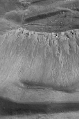
Ascraeus Mons is a large shield volcano
located in the Tharsis
region of the planet
Mars
. It is the northernmost and tallest of three shield volcanoes collectively known as the Tharsis Montes
. The volcano's location corresponds to the classical albedo feature
Ascraeus Lacus.
Ascraeus Mons was discovered by the Mariner 9
spacecraft in 1971. The volcano was originally called North Spot because it was the northernmost of only four spots visible on the surface due to a global dust storm that was then enshrouding the planet.
Shield volcano
A shield volcano is a type of volcano usually built almost entirely of fluid lava flows. They are named for their large size and low profile, resembling a warrior's shield. This is caused by the highly fluid lava they erupt, which travels farther than lava erupted from more explosive volcanoes...
located in the Tharsis
Tharsis
The Tharsis region on Mars is a vast volcanic plateau centered near the equator in Mars’ western hemisphere. The region is home to the largest volcanoes in the Solar System, including the three enormous shield volcanoes Arsia Mons, Pavonis Mons, and Ascraeus Mons, which are collectively known as...
region of the planet
Planet
A planet is a celestial body orbiting a star or stellar remnant that is massive enough to be rounded by its own gravity, is not massive enough to cause thermonuclear fusion, and has cleared its neighbouring region of planetesimals.The term planet is ancient, with ties to history, science,...
Mars
Mars
Mars is the fourth planet from the Sun in the Solar System. The planet is named after the Roman god of war, Mars. It is often described as the "Red Planet", as the iron oxide prevalent on its surface gives it a reddish appearance...
. It is the northernmost and tallest of three shield volcanoes collectively known as the Tharsis Montes
Tharsis Montes
The Tharsis Montes are three large shield volcanoes in the Tharsis region of the planet Mars. From north to south, the volcanoes are Ascraeus Mons, Pavonis Mons and Arsia Mons. Mons is the Latin word for mountain...
. The volcano's location corresponds to the classical albedo feature
Classical albedo features on Mars
The classical albedo features of Mars are the light and dark features that can be seen on the planet Mars through an Earth-based telescope. Before the age of space probes, several astronomers created maps of Mars on which they gave names to the features they could see. The most popular system of...
Ascraeus Lacus.
Ascraeus Mons was discovered by the Mariner 9
Mariner 9
Mariner 9 was a NASA space orbiter that helped in the exploration of Mars and was part of the Mariner program. Mariner 9 was launched toward Mars on May 30, 1971 from Cape Canaveral Air Force Station and reached the planet on November 13 of the same year, becoming the first spacecraft to orbit...
spacecraft in 1971. The volcano was originally called North Spot because it was the northernmost of only four spots visible on the surface due to a global dust storm that was then enshrouding the planet.
Discussions