
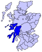
Argyll
Encyclopedia
Argyll archaically Argyle (Earra-Ghàidheal in modern Gaelic
ˈaːr̴əɣɛː.əɫ̪), is a region of western Scotland
corresponding with most of the part of ancient Dál Riata
that was located on the island of Great Britain
, and in a historical context can be used to mean the entire western coast between the Mull of Kintyre
and Cape Wrath
. Argyll was also a medieval Bishopric
with its cathedral at Lismore
, as well as an early modern Earldom and Duchy
, the Duchy of Argyll
.
explains that "the name Arregathel means margin (ie, border region) of the Scots or Irish, because all Scots and Irish are generally called Gattheli (i.e. Gaels), from their ancient warleader known as Gaithelglas."
However, the word airer naturally carries the meaning of the word 'coast' when applied to maritime regions, so the placename can also be translated as "Coast of [the] Gaels". Woolf has suggested that the name Airer Goídel replaced the name Dál Riata when the 9th century Norse conquest split Irish Dál Riata and the islands of Alban Dál Riata off from mainland Alban Dál Riata; the mainland area, renamed Airer Goídel, would have contrasted with the offshore islands of Innse Gall, literally "islands of the foreigners", so-called because during the 9th to 12th centuries they were ruled by Norse-speaking Gall-Gaels
.
of Scotland
and additionally between 1890 and 1975 it was a county for local government purposes. Argyll's neighbouring counties are Inverness-shire
, Perthshire
, Dunbartonshire
, Renfrewshire
, Ayrshire
and Bute
. Renfrewshire and Ayrshire are the other side of the Firth of Clyde
. Bute is a county of islands in the firth
.
The county town was historically Inveraray
, which is still the seat of the Duke of Argyll
. Lochgilphead
later claimed to be the county town, as the seat of local government for the county from the nineteenth century. Neither town was the largest settlement geographically nor in terms of population, however. Argyll's largest towns were (and are) Oban
, Dunoon
and Campbeltown
.
The Small Isles
were part of the county, until they were transferred to Inverness-shire
in 1891, by the boundary commission appointed under the Local Government (Scotland) Act 1889
.
The use of the County of Argyll for local government purposes ceased in 1975 with its area being split between Highland
and Strathclyde Regions. A local government district called Argyll and Bute was formed in the Strathclyde
region, including most of Argyll and the Isle of Bute
. The Ardnamurchan
, Ballachulish
and Kinlochleven
areas of Argyll became part of Lochaber
District, in Highland.
In 1996 a new unitary council area of Argyll and Bute
was created, with a change to boundaries to include part of the former Strathclyde district of Dumbarton.
of the Parliament of Great Britain
from 1708 to 1801 and of the Parliament of the United Kingdom
from 1801 to 1983 (renamed Argyll in 1950). The Argyll and Bute constituency
was created when the Argyll constituency was abolished.
's 1965 novel The Mark of the Horse Lord
is set in Earra Gael, i.e. the Coast of the Gael, wherein the Dal Riada undergo an internal struggle for control of royal succession, and an external conflict to defend their frontiers against the Caledones
.
Scottish Gaelic language
Scottish Gaelic is a Celtic language native to Scotland. A member of the Goidelic branch of the Celtic languages, Scottish Gaelic, like Modern Irish and Manx, developed out of Middle Irish, and thus descends ultimately from Primitive Irish....
ˈaːr̴əɣɛː.əɫ̪), is a region of western Scotland
Scotland
Scotland is a country that is part of the United Kingdom. Occupying the northern third of the island of Great Britain, it shares a border with England to the south and is bounded by the North Sea to the east, the Atlantic Ocean to the north and west, and the North Channel and Irish Sea to the...
corresponding with most of the part of ancient Dál Riata
Dál Riata
Dál Riata was a Gaelic overkingdom on the western coast of Scotland with some territory on the northeast coast of Ireland...
that was located on the island of Great Britain
Great Britain
Great Britain or Britain is an island situated to the northwest of Continental Europe. It is the ninth largest island in the world, and the largest European island, as well as the largest of the British Isles...
, and in a historical context can be used to mean the entire western coast between the Mull of Kintyre
Mull of Kintyre
The Mull of Kintyre is the southwesternmost tip of the Kintyre Peninsula in southwest Scotland. From here, the Antrim coast is visible and an historic lighthouse, the second commissioned in Scotland, guides shipping in the intervening North Channel...
and Cape Wrath
Cape Wrath
Cape Wrath is a cape in Sutherland, Highland, in northern Scotland. It is the most northwesterly point on the island of Great Britain. The land between the Kyle of Durness and the lighthouse that is situated right at the tip, is known as the Parph, two hundred and seven square kilometers of...
. Argyll was also a medieval Bishopric
Diocese of Argyll
The Diocese of Argyll was an ecclesiastical territory or diocese in Scotland in the Middle Ages. The Diocese was led by the Bishop of Argyll, and was based at Lismore....
with its cathedral at Lismore
Lismore, Scotland
Lismore is a partially Gaelic speaking island in the Inner Hebrides of Scotland. This fertile, low-lying island was once a major centre of Celtic Christianity, with a monastery founded by Saint Moluag and the seat of the Bishop of Argyll.-Geography:...
, as well as an early modern Earldom and Duchy
Duchy
A duchy is a territory, fief, or domain ruled by a duke or duchess.Some duchies were sovereign in areas that would become unified realms only during the Modern era . In contrast, others were subordinate districts of those kingdoms that unified either partially or completely during the Medieval era...
, the Duchy of Argyll
Duke of Argyll
Duke of Argyll is a title, created in the Peerage of Scotland in 1701 and in the Peerage of the United Kingdom in 1892. The Earls, Marquesses, and Dukes of Argyll were for several centuries among the most powerful, if not the most powerful, noble family in Scotland...
.
Etymology
The name derives from Old Gaelic airer Goídel (border region of the Gaels). The early thirteenth century author of De Situ AlbanieDe Situ Albanie
De Situ Albanie is the name given to the first of seven Scottish documents found in the so-called Poppleton Manuscript, now in the Bibliothèque Nationale, Paris...
explains that "the name Arregathel means margin (ie, border region) of the Scots or Irish, because all Scots and Irish are generally called Gattheli (i.e. Gaels), from their ancient warleader known as Gaithelglas."
However, the word airer naturally carries the meaning of the word 'coast' when applied to maritime regions, so the placename can also be translated as "Coast of [the] Gaels". Woolf has suggested that the name Airer Goídel replaced the name Dál Riata when the 9th century Norse conquest split Irish Dál Riata and the islands of Alban Dál Riata off from mainland Alban Dál Riata; the mainland area, renamed Airer Goídel, would have contrasted with the offshore islands of Innse Gall, literally "islands of the foreigners", so-called because during the 9th to 12th centuries they were ruled by Norse-speaking Gall-Gaels
Norse-Gaels
The Norse–Gaels were a people who dominated much of the Irish Sea region, including the Isle of Man, and western Scotland for a part of the Middle Ages; they were of Gaelic and Scandinavian origin and as a whole exhibited a great deal of Gaelic and Norse cultural syncretism...
.
County and district
Argyll (sometimes anglified as Argyllshire) is a registration countyRegistration county
A registration county was, in Great Britain and Ireland, a statistical unit used for the registration of births, deaths and marriages and for the output of census information. In Scotland registration counties are used for land registration purposes....
of Scotland
Scotland
Scotland is a country that is part of the United Kingdom. Occupying the northern third of the island of Great Britain, it shares a border with England to the south and is bounded by the North Sea to the east, the Atlantic Ocean to the north and west, and the North Channel and Irish Sea to the...
and additionally between 1890 and 1975 it was a county for local government purposes. Argyll's neighbouring counties are Inverness-shire
Inverness-shire
The County of Inverness or Inverness-shire was a general purpose county of Scotland, with the burgh of Inverness as the county town, until 1975, when, under the Local Government Act 1973, the county area was divided between the two-tier Highland region and the unitary Western Isles. The Highland...
, Perthshire
Perthshire
Perthshire, officially the County of Perth , is a registration county in central Scotland. It extends from Strathmore in the east, to the Pass of Drumochter in the north, Rannoch Moor and Ben Lui in the west, and Aberfoyle in the south...
, Dunbartonshire
Dunbartonshire
Dunbartonshire or the County of Dumbarton is a lieutenancy area and registration county in the west central Lowlands of Scotland lying to the north of the River Clyde. Until 1975 it was a county used as a primary unit of local government with its county town and administrative centre at the town...
, Renfrewshire
Renfrewshire
Renfrewshire is one of 32 council areas used for local government in Scotland. Located in the west central Lowlands, it is one of three council areas contained within the boundaries of the historic county of Renfrewshire, the others being Inverclyde to the west and East Renfrewshire to the east...
, Ayrshire
Ayrshire
Ayrshire is a registration county, and former administrative county in south-west Scotland, United Kingdom, located on the shores of the Firth of Clyde. Its principal towns include Ayr, Kilmarnock and Irvine. The town of Troon on the coast has hosted the British Open Golf Championship twice in the...
and Bute
County of Bute
The County of Bute is one of the registration counties of Scotland. In 2001 its usually resident population was 13,720.-Local government county:...
. Renfrewshire and Ayrshire are the other side of the Firth of Clyde
Firth of Clyde
The Firth of Clyde forms a large area of coastal water, sheltered from the Atlantic Ocean by the Kintyre peninsula which encloses the outer firth in Argyll and Ayrshire, Scotland. The Kilbrannan Sound is a large arm of the Firth of Clyde, separating the Kintyre Peninsula from the Isle of Arran.At...
. Bute is a county of islands in the firth
Firth
Firth is the word in the Lowland Scots language and in English used to denote various coastal waters in Scotland and England. In mainland Scotland it is used to describe a large sea bay, or even a strait. In the Northern Isles it more usually refers to a smaller inlet...
.
The county town was historically Inveraray
Inveraray
Inveraray is a royal burgh in Argyll and Bute, Scotland. It is on the western shore of Loch Fyne, near its head, and on the A83 road. It is the traditional county town of Argyll and ancestral home to the Duke of Argyll.-Coat of arms:...
, which is still the seat of the Duke of Argyll
Duke of Argyll
Duke of Argyll is a title, created in the Peerage of Scotland in 1701 and in the Peerage of the United Kingdom in 1892. The Earls, Marquesses, and Dukes of Argyll were for several centuries among the most powerful, if not the most powerful, noble family in Scotland...
. Lochgilphead
Lochgilphead
Lochgilphead is a town and former burgh in Scotland, with a population of around 3,000 people. It is the administrative centre of Argyll and Bute. The town lies at the end of Loch Gilp and lies on the banks of the Crinan Canal....
later claimed to be the county town, as the seat of local government for the county from the nineteenth century. Neither town was the largest settlement geographically nor in terms of population, however. Argyll's largest towns were (and are) Oban
Oban
Oban Oban Oban ( is a resort town within the Argyll and Bute council area of Scotland. It has a total resident population of 8,120. Despite its small size, it is the largest town between Helensburgh and Fort William and during the tourist season the town can be crowded by up to 25,000 people. Oban...
, Dunoon
Dunoon
Dunoon is a resort town situated on the Cowal Peninsula in Argyll, Scotland. It sits on the Firth of Clyde to the south of Holy Loch and to the west of Gourock.-Waterfront:...
and Campbeltown
Campbeltown
Campbeltown is a town and former royal burgh in Argyll and Bute, Scotland. It lies by Campbeltown Loch on the Kintyre peninsula. Originally known as Kinlochkilkerran , it was renamed in the 17th century as Campbell's Town after Archibald Campbell was granted the site in 1667...
.
The Small Isles
Small Isles
The Small Isles are a small archipelago of islands in the Inner Hebrides, off the west coast of Scotland. They lie south of Skye and north of Mull and Ardnamurchan – the most westerly point of mainland Scotland.The four main islands are Canna, Rùm, Eigg and Muck...
were part of the county, until they were transferred to Inverness-shire
Inverness-shire
The County of Inverness or Inverness-shire was a general purpose county of Scotland, with the burgh of Inverness as the county town, until 1975, when, under the Local Government Act 1973, the county area was divided between the two-tier Highland region and the unitary Western Isles. The Highland...
in 1891, by the boundary commission appointed under the Local Government (Scotland) Act 1889
Local Government (Scotland) Act 1889
The Local Government Act 1889 is an Act of the Parliament of the United Kingdom which was passed on 26 August 1889. The main effect of the Act was to establish elected county councils in Scotland...
.
The use of the County of Argyll for local government purposes ceased in 1975 with its area being split between Highland
Highland (council area)
Highland is a council area in the Scottish Highlands and is the largest local government area in both Scotland and the United Kingdom as a whole. It shares borders with the council areas of Moray, Aberdeenshire, Perth and Kinross, and Argyll and Bute. Their councils, and those of Angus and...
and Strathclyde Regions. A local government district called Argyll and Bute was formed in the Strathclyde
Strathclyde
right|thumb|the former Strathclyde regionStrathclyde was one of nine former local government regions of Scotland created by the Local Government Act 1973 and abolished in 1996 by the Local Government etc Act 1994...
region, including most of Argyll and the Isle of Bute
Isle of Bute
Bute is an island in the Firth of Clyde in Scotland. Formerly part of the county of Buteshire, it now constitutes part of the council area of Argyll and Bute. Its resident population was 7,228 in April 2001.-Geography:...
. The Ardnamurchan
Ardnamurchan
Ardnamurchan is a peninsula in Lochaber, Highland, Scotland, noted for being very unspoilt and undisturbed. Its remoteness is accentuated by the main access route being a single track road for much of its length.-Geography:...
, Ballachulish
Ballachulish
The village of Ballachulish in Lochaber, Highland, Scotland, is centred around former slate quarries. The name Ballachulish was more correctly applied to the area now called North Ballachulish, to the north of Loch Leven, but was usurped for the quarry villages at East Laroch and West Laroch,...
and Kinlochleven
Kinlochleven
Kinlochleven is a village in Lochaber, in the Scottish Highlands and lies at the eastern end of Loch Leven, a sea loch cutting into the western Scottish Highlands. To the north lie the Mamores ridge; to the south lie the mountains flanking Glen Coe...
areas of Argyll became part of Lochaber
Lochaber
District of Lochaber 1975 to 1996Highland council area shown as one of the council areas of ScotlandLochaber is one of the 16 ward management areas of the Highland Council of Scotland and one of eight former local government districts of the two-tier Highland region...
District, in Highland.
In 1996 a new unitary council area of Argyll and Bute
Argyll and Bute
Argyll and Bute is both one of 32 unitary council areas; and a Lieutenancy area in Scotland. The administrative centre for the council area is located in Lochgilphead.Argyll and Bute covers the second largest administrative area of any Scottish council...
was created, with a change to boundaries to include part of the former Strathclyde district of Dumbarton.
Constituency
There was an Argyllshire constituencyArgyllshire (UK Parliament constituency)
Argyllshire was a county constituency of the House of Commons of the Parliament of Great Britain from 1708 to 1800 and of the House of Commons of the Parliament of the United Kingdom from 1801 until 1950, when it was renamed Argyll...
of the Parliament of Great Britain
Parliament of Great Britain
The Parliament of Great Britain was formed in 1707 following the ratification of the Acts of Union by both the Parliament of England and Parliament of Scotland...
from 1708 to 1801 and of the Parliament of the United Kingdom
Parliament of the United Kingdom
The Parliament of the United Kingdom of Great Britain and Northern Ireland is the supreme legislative body in the United Kingdom, British Crown dependencies and British overseas territories, located in London...
from 1801 to 1983 (renamed Argyll in 1950). The Argyll and Bute constituency
Argyll and Bute (UK Parliament constituency)
Argyll and Bute is a county constituency of the House of Commons of the Parliament of the United Kingdom. It was created for the 1983 general election, merging most of Argyll with some of Bute and Northern Ayrshire...
was created when the Argyll constituency was abolished.
Notable residents
- Patrick MacKellar, (1717-1778), born in Argyll, military engineer, considered the most competent engineer in America.
- Baron Robertson of Port EllenGeorge Robertson, Baron Robertson of Port EllenGeorge Islay MacNeill Robertson, Baron Robertson of Port Ellen, is a British Labour Party politician who was the tenth Secretary General of the North Atlantic Treaty Organisation, between October 1999 and early January 2004; he succeeded Javier Solana in that position...
KT, GCMG, FRSA, FRSE, PC (born 12 April 1946, George Islay MacNeill Robertson,) is a British LabourLabour Party (UK)The Labour Party is a centre-left democratic socialist party in the United Kingdom. It surpassed the Liberal Party in general elections during the early 1920s, forming minority governments under Ramsay MacDonald in 1924 and 1929-1931. The party was in a wartime coalition from 1940 to 1945, after...
politician who was the tenth Secretary General of the North Atlantic Treaty Organisation, between October 1999 and January 2004.
In fiction
Rosemary SutcliffRosemary Sutcliff
Rosemary Sutcliff CBE was a British novelist, and writer for children, best known as a writer of historical fiction and children's literature. Although she was primarily a children's author, the quality and depth of her writing also appeals to adults; Sutcliff herself once commented that she wrote...
's 1965 novel The Mark of the Horse Lord
The Mark of the Horse Lord
The Mark of the Horse Lord is a historical novel for children written by Rosemary Sutcliff and published in 1965. It won the first Phoenix Award in 1985....
is set in Earra Gael, i.e. the Coast of the Gael, wherein the Dal Riada undergo an internal struggle for control of royal succession, and an external conflict to defend their frontiers against the Caledones
Caledonians
The Caledonians , or Caledonian Confederacy, is a name given by historians to a group of indigenous peoples of what is now Scotland during the Iron Age and Roman eras. The Romans referred to their territory as Caledonia and initially included them as Britons, but later distinguished as the Picts...
.