

Archaeological geophysics
Encyclopedia
Geophysical survey
Geophysical survey is the systematic collection of geophysical data for spatial studies. Geophysical surveys may use a great variety of sensing instruments, and data may be collected from above or below the Earth's surface or from aerial or marine platforms. Geophysical surveys have many...
in archaeology
Archaeology
Archaeology, or archeology , is the study of human society, primarily through the recovery and analysis of the material culture and environmental data that they have left behind, which includes artifacts, architecture, biofacts and cultural landscapes...
most often refers to ground-based physical sensing techniques used for archaeological imaging or mapping. Remote sensing
Remote sensing
Remote sensing is the acquisition of information about an object or phenomenon, without making physical contact with the object. In modern usage, the term generally refers to the use of aerial sensor technologies to detect and classify objects on Earth by means of propagated signals Remote sensing...
and marine surveys are also used in archaeology, but are generally considered separate disciplines. Other terms, such as "geophysical prospection" and "archaeological geophysics" are generally synonymous.
Overview
Geophysical survey is used to create maps of subsurface archaeological featuresFeature (archaeology)
Feature in archaeology and especially excavation has several different but allied meanings. A feature is a collection of one or more contexts representing some human non-portable activity that generally has a vertical characteristic to it in relation to site stratigraphy. Examples of features are...
. Features are the non-portable part of the archaeological record
Archaeological record
The archaeological record is the body of physical evidence about the past. It is one of the most basic concepts in archaeology, the academic discipline concerned with documenting and interpreting the archaeological record....
, whether standing structures or traces of human activities left in the soil
Soil
Soil is a natural body consisting of layers of mineral constituents of variable thicknesses, which differ from the parent materials in their morphological, physical, chemical, and mineralogical characteristics...
. Geophysical instruments can detect buried features when their physical properties contrast measurably with their surroundings. In some cases individual artifacts
Artifact (archaeology)
An artifact or artefact is "something made or given shape by man, such as a tool or a work of art, esp an object of archaeological interest"...
, especially metal, may be detected as well. Readings taken in a systematic pattern become a data set
Data set
A data set is a collection of data, usually presented in tabular form. Each column represents a particular variable. Each row corresponds to a given member of the data set in question. Its values for each of the variables, such as height and weight of an object or values of random numbers. Each...
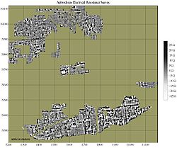
that can be rendered as image maps. Survey results can be used to guide excavation and to give archaeologists insight into the patterning of non-excavated parts of the site. Unlike other archaeological methods, geophysical survey is neither invasive nor destructive. For this reason, it is often used where preservation (rather than excavation) is the goal, and to avoid disturbance of culturally sensitive sites such as cemeteries.
Although Geophysical survey has been used in the past with intermittent success, good results are very likely when it is applied appropriately. It is most useful when it is used in a well-integrated research design where interpretations can be tested and refined. Interpretation requires a knowledge both of the archaeological record, and of the way it is expressed geophysically. Appropriate instrumentation, survey design, and data processing are essential for success, and must be adapted to the unique geology
Geology
Geology is the science comprising the study of solid Earth, the rocks of which it is composed, and the processes by which it evolves. Geology gives insight into the history of the Earth, as it provides the primary evidence for plate tectonics, the evolutionary history of life, and past climates...
and archaeological record of each site. In the field, control of data quality and spatial accuracy are critical.
Methods
Engineering
Engineering is the discipline, art, skill and profession of acquiring and applying scientific, mathematical, economic, social, and practical knowledge, in order to design and build structures, machines, devices, systems, materials and processes that safely realize improvements to the lives of...
, and geology
Geology
Geology is the science comprising the study of solid Earth, the rocks of which it is composed, and the processes by which it evolves. Geology gives insight into the history of the Earth, as it provides the primary evidence for plate tectonics, the evolutionary history of life, and past climates...
. Archaeological mapping presents unique challenges, however, which have spurred a separate development of methods and equipment. In general, geological applications are concerned with detecting relatively large structures, often as deeply as possible. In contrast, most archaeological sites are relatively near the surface, often within the top meter of earth. Instruments are often configured to limit the depth of response to better resolve the near-surface phenomena that are likely to be of interest. Another challenge is to detect subtle and often very small features – which may be as ephemeral as organic staining from decayed wooden posts - and distinguish them from rocks, roots, and other natural “clutter.” To accomplish this requires not only sensitivity, but also high density of data points, usually at least one and sometimes dozens of readings per square meter.
Most commonly applied to archaeology are magnetometer
Magnetometer
A magnetometer is a measuring instrument used to measure the strength or direction of a magnetic field either produced in the laboratory or existing in nature...
s, electrical resistance
Electrical resistance
The electrical resistance of an electrical element is the opposition to the passage of an electric current through that element; the inverse quantity is electrical conductance, the ease at which an electric current passes. Electrical resistance shares some conceptual parallels with the mechanical...
meters, ground-penetrating radar
Ground-penetrating radar
Ground-penetrating radar is a geophysical method that uses radar pulses to image the subsurface. This nondestructive method uses electromagnetic radiation in the microwave band of the radio spectrum, and detects the reflected signals from subsurface structures...
(GPR) and electromagnetic (EM) conductivity meters. These methods can resolve many types of archaeological features, are capable of high sample density surveys of very large areas, and of operating under a wide range of conditions. While common metal detector
Metal detector
A metal detector is a device which responds to metal that may not be readily apparent.The simplest form of a metal detector consists of an oscillator producing an alternating current that passes through a coil producing an alternating magnetic field...
s are geophysical sensors, they are not capable of generating high-resolution imagery. Other established and emerging technologies are also finding use in archaeological applications.
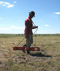
Electrical resistance meters can be thought of as similar to the Ohmmeter
Ohmmeter
An ohmmeter is an electrical instrument that measures electrical resistance, the opposition to an electric current. Micro-ohmmeters make low resistance measurements. Megohmmeters measure large values of resistance...
s used to test electrical circuits. In most systems, metal probes are inserted into the ground to obtain a reading of the local electrical resistance. A variety of probe configurations are used, most having four probes, often mounted on a rigid frame. Capacatively coupled systems that do not require direct physical contact with the soil have also been developed. Archaeological features can be mapped when they are of higher or lower resistivity than their surroundings. A stone foundation might impede the flow of electricity, while the organic deposits within a midden might conduct electricity more easily than surrounding soils. Although generally used in archaeology for planview mapping, resistance methods also have a limited ability to discriminate depth and create vertical profiles (see Electrical resistivity tomography
Electrical resistivity tomography
Electrical resistivity tomography or electrical resistivity imaging is a geophysical technique for imaging sub-surface structures from electrical measurements made at the surface, or by electrodes in one or more boreholes. It is closely related to the medical imaging technique electrical...
).
Electromagnetic (EM) conductivity instruments have a response that is comparable to that of resistance meters (conductivity is the inverse of resistance). Although EM conductivity instruments are generally less sensitive than resistance meters to the same phenomena, they do have a number of unique properties. One advantage is that they do not require direct contact with the ground, and can be used in conditions unfavorable to resistance meters. Another advantage is relatively greater speed than resistance instruments. Unlike resistance instruments, conductivity meters respond strongly to metal. This can be a disadvantage when the metal is extraneous to the archaeological record, but can be useful when the metal is of archaeological interest. Some EM conductivity instruments are also capable of measuring magnetic susceptibility
Magnetic susceptibility
In electromagnetism, the magnetic susceptibility \chi_m is a dimensionless proportionality constant that indicates the degree of magnetization of a material in response to an applied magnetic field...
, a property that is becoming increasingly important in archaeological studies.
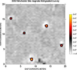
Gradiometer
A gradiometer measures the gradient of a physical quantity, such as a magnetic field or gravity.-Types of gradiometer:There are at least two types of gradiometer to measure magnetic fields:...
) configuration is preferred because it provides better resolution of small, near-surface phenomena. Magnetometers may also use a variety of different sensor types. Proton precession magnetometers have largely been superseded by faster and more sensitive fluxgate and cesium instruments.
Every kind of material has unique magnetic properties, even those that we do not think of as being “magnetic.” Different materials below the ground can cause local disturbances in the Earth’s magnetic field that are detectable with sensitive magnetometers. Magnetometers react very strongly to iron and steel, brick, burned soil, and many types of rock, and archaeological features composed of these materials are very detectable. Where these highly magnetic materials do not occur, it is often possible to detect very subtle anomalies caused by disturbed soils or decayed organic materials. The chief limitation of magnetometer survey is that subtle features of interest may be obscured by highly magnetic geologic or modern materials.
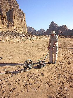
GPR can be a powerful tool in favorable conditions (uniform sandy soils are ideal). It is unique both in its ability to detect some spatially small objects at relatively great depths and in its ability to distinguish the depth of anomaly sources. The principal disadvantage of GPR is that it is severely limited by less-than-ideal conditions. The high electrical conductivity of fine-grained sediments (clays and silts) causes conductive losses of signal strength; rocky or heterogeneous sediments scatter the GPR signal. Another disadvantage is that data collection is relatively slow.
Metal detectors use electromagnetic induction to detect metal. Although other types of instruments (notably magnetometers and electromagnetic conductivity meters) have some sensitivity to metal, specialized metal detectors are much more effective. Metal detectors are available in different configurations, varying in sophistication and sensitivity. Most have some capacity to discriminate between different types of metallic targets.
Common hand-held metal detectors are widely used by archaeologists. Most of these instruments do not create a logged data set and thus cannot be used for directly creating maps, but used in a systematic manner they can be a useful tool in archaeological research. Sometimes external data loggers are attached to such detectors which collect information about detected materials and corresponding gps coordinates for further processing. Misuse of these instruments on archaeological sites by treasure hunters and artifact collectors has been a serious problem in archaeological preservation.
Although not as commonly used in archaeology, sophisticated metal detectors are available having much greater sensitivity than hand-held models. These instruments are capable of data logging and sophisticated target discrimination. They can be mounted on wheeled carts for survey data collection.
Data collection is broadly similar regardless of the particular sensing instrument. Survey usually involves walking with the instrument along closely spaced parallel traverses, taking readings at regular intervals. In most cases, the area to be surveyed is staked into a series of square or rectangular survey "grids" (terminology can vary). With the corners of the grids as known reference points, the instrument operator uses tapes or marked ropes as a guide when collecting data. In this way, positioning error can be kept to within a few centimeters for high-resolution mapping. Survey systems with integrated global positioning systems (GPS) have been developed, but under field conditions, currently available systems lack sufficient precision for high-resolution archaeological mapping. Geophysical instruments (notably metal detectors) may also used for less formally "scanning" areas of interest.
Data processing and imaging convert raw numeric data into interpretable maps. Data processing usually involves the removal of statistical outliers and noise, and interpolation of data points. Statistical filters may be designed to enhance features of interest (based on size, strength, orientation, or other criteria), or suppress obscuring modern or natural phenomena. Inverse modeling
Inverse problem
An inverse problem is a general framework that is used to convert observed measurements into information about a physical object or system that we are interested in...
of archaeological features from observed data is becoming increasingly important. Processed data are typically rendered as images, as contour maps, or in false relief. When geophysical data are rendered graphically, the interpreter can more intuitively recognize cultural and natural patterns and visualize the physical phenomena causing the detected anomalies.
Development
The use of geophysical survey is well established in European archaeology, especially in Great Britain, where it was pioneered in the 1940s and 1950s. It is increasingly employed in other parts of the world, and with increasing success as techniques are adapted to unique regional conditions.In early surveys, measurements were recorded individually and plotted by hand. Although useful results were sometimes obtained, practical applications were limited by the enormous amount of labor required. Data processing was minimal and sample densities were necessarily low.
Although the sensitivity of sensors has improved, and new methods have been developed, the most important developments have been automated data logging and computers to handle and process large amounts of data. Continuing improvements in survey equipment performance and automation have made it possible to rapidly survey large areas. Rapid data collection has also made it practical to achieve the high sample densities necessary to resolve small or subtle features. Advances in processing and imaging software have made it possible to detect, display, and interpret subtle archaeological patterning within the geophysical data.
See also
- Magnetic survey (archaeology)Magnetic survey (archaeology)Magnetic survey is one of a number of methods used in archaeological geophysics. Magnetic surveys record spatial variation in the Earth's magnetic field. In archaeology, magnetic surveys are used to detect and map archaeological artifacts and features...
- Ground penetrating radar survey (archaeology)Ground penetrating radar survey (archaeology)Ground penetrating radar survey is one of a number of methods used in archaeological geophysics. GPR can be used to detect and map subsurface archaeological artifacts, features, and patterning.- Overview :...
- Electrical resistance survey (archaeology)Electrical resistance survey (archaeology)Electrical resistance survey is one of a number of methods used in archaeological geophysics...
- Remote sensing (archaeology)Remote sensing (archaeology)Remote sensing techniques in archaeology are an increasingly important component of the technical and methodological tool set available in archaeological research.. The use of remote sensing techniques allows archaeologists to uncover unique data that is unobtainable using traditional...